The City where Route 66 was Born
Index to this page
About Springfield Missouri
Facts, Trivia and useful information
"Queen City of the Ozarks"
Elevation: 1,299 ft (396 m). Population 179,621 (2025) and its Metro area 475,000 est. 2025 (126th in the U.S.)
Time zone: Central (CST): UTC minus 6 hours. Summer (DST) CDT (UTC-5).
Springfield is a large city on Old Route 66, and seat of Greene County. Located in south-central Missouri.
History of Springfield
Southwestern Missouri has been inhabited since the last Ice Age, around ten thousand years ago; more recently around 700 BC the native Osage migrated here from their homeland on the Ohio and Mississippi rivers after being expelled by the warmongering Iroquois.
French explorers who came from Canada claimed the area in 1682 and named it "Louisiana" after their king Louis XIV. France sold it to the U.S. in 1803 and in 1812 it was organized as the Missouri Territory , becoming a state in 1821.
At that time there were Delaware and Kickapoo natives in Springfield. The Kickapoo natives originally lived in Indiana and Illinois, but after rising pressure from white settlers and the Tecumseh War against the US in 1811, they were removed west of the Mississippi River into Missouri, south of the Osage River. They lived in lodges with an oblong shape, built with saplings, roofed and faced with bark or reed-mats known as "wickiups".
Thomas Patterson settled in Springfield in 1821 after buying John Pettijohn's claim. However the Kickapoo Indians claimed the land as theirs under a treaty signed with the government. White settlers were forced to leave, except James Wilson, who married into the tribe (see the Kickapoo Indian Village historic marker on Page #2).
After the natives were moved again, in 1832 into Reservation land in Kansas, Texas and Oklahoma, John Polk Campbell and his brother settled there in Kickapoo Prairie next to a spring.
In 1833 when Greene County was created, Campbell and his wife deeded 50 acres of land for a townsite which incorporated in 1838.
The name: Springfield
One version is that Campbell named the town after the spring next to his homestead, another that one of the early settlers, James Wilson came from Springfield Massachusetts (in turn named by William Pyncheon in 1636 after his home town in Essex, England).
The Cherokee Tribe was also relocated in Oklahoma, in 1839, their march is known as the "Trail of Tears" during which thousands of natives perished. Route 66 follows the ancient trail used by the Cherokee.
Located at a strategic crossroad, settlers began arriving in 1850 and by 1859 it had 2,500 residents. The Butterfield Stage Line set up a station there for its route to San Francisco.
During the Civl War, after the bloody battle of Wilson's Creek, in 1861, the Confederates held the area until the Union forces drove them out in 1862 and held the town until the end of the war.
The railway (Atlantic and Pacific Railroad) reached Springfield in 1870 and set up a station 1.5 mi. north of the town, prompting the creation of North Springfield. The Kansas City, Fort Scott and Memphis Railroad reached the town in 1881, and both communities merged in 1887.
Springfield played an important role in the creation of Route 66, and is known as The Birthplace of Route 66, which was aligned through the city in 1926 and realigned in 1936 around its northern and western sides. The city provided lodging and services to those travelling along Route 66.
After 1958, I-44 which at that time overlapped US-66 was built and bypassed the city. Route 66 traffic was drawn to the freeway.
Where to Lodge in Springfield, Missouri
Lodging in Springfield. There are many options in the city. You can find your room very easily.
>> Book your Hotels in Springfield
More Hotels close to Springfield along Route 66
There are several hotels in the area close to this town. Alternatively you can also find your accommodation along Route 66 in the neighboring towns and cities in Missouri. We list them below (from east to west):
On Route 66's Main alignment in MO
Eastwards
Westwards
- Hotels in Kansas
- Baxter Springs KS
- Galena KS
- Riverton KS
- Hotels in Oklahoma
- Miami OK
>> Check out the RV campgrounds in Springfield
Weather in Springfield
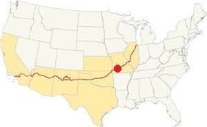
Location of Springfield on Route 66
Springfield has clearly defined seasons. The city is located on the northern border of U.S.'s humid subtropical climate, this gives it very wet weather in late summer. The average summer (Jul) high is 89°F (31.6°C) and low 68° (19.8°C); the average winter (Jan) high is 43°F (6.1°C), lows are below freezing point: 22°F (-5.3°C).
Annual rainfall reaches 45.6 in. (1.160 mm). Yearly Snowfall is 17 in. (43 cm).
Springfield is said to be the city with the most varied weather in the United States.
Tornado risk
Springfield is located within the "Tornado Alley". Greene County has an average of 9 tornado strikes per year. Tornado Risk: read more about Tornado Risk along Route 66.
Route 66 map in Springfield MO
>> Custom map with the alignments of US66 across Springfield.
Alignments in Springfield
The thumbnail map (click on it to enlarge) shows all of the alignments of Route 66 across Springfield, Missouri.
1926-1930 Route 66 into Springfield
Coming from Strafford, towards Springfield the first alignment of Route 66 followed the alignment shown in this 1926-30 US 66 map (orange and red lines).
1930-77 Route 66 (City 66) into Springfield
When the highway was paved in 1930 it was realigned to the north and entered the city along what is now MO-66 and Glenstone Ave. See this map of City US 66 into Springfield (violet line).
Then it followed the original 1926 alignment through Springfield's downtown area.
1926-77 Route 66 (City 66) across Springfield
This is the map of City US 66 map across downtown Springfield (red line).
1936-54 Bypass 66 around Springfield.
In his "Guidebook to US Highway 66", Jack Rittenhouse pointed out back in 1946 that "There are two routes: through the town on City 66 or around it on Bypass 66" the bypass was created in 1936 because traffic congested the commercial district of Springfield (it also carried US 65) so a bypass was approved and built around the city.
It solved the problem. Rittenhouse added that those driving "Straight through in a hurry" should take the bypass because it "avoid[ed] city traffic".
It would remain in use until 1954. Bypass 66 map. (blue line)
1955-1977 Route 66
In 1955 Route 66 was aligned along I-44 and remained there until it was decertified in both Illinois and most of Missouri in 1978.
The alignment near Springfield
Visit our pages, with old maps and plenty of information about US 66's alignments.
- Springfield to Joplin (next)
- Rolla to Springfield (previous)
Sights and Attractions in Springfield, Missouri
What to Do, Places to See (Page 1)
Historic context, the classic Route 66 in Springfield
In his 1946 book "A Guide Book to Highway 66" Jack DeVere Rittenhouse describes the "classic" Route 66 during its heyday. He says the following.
... all types of accommodations... There are plenty of courts on all approaches to the city, and several hotels in town.
Largest hotels are: Colonial, Kentwood Arms, Seville and Metropolitan; also Milner, State and Sterling Hotels. Tourist Courts include: Cordova, Lone Star, Baldridge, Black's, Camp-On-A-Way, Curtis, DeLuxe, Eagle, Lone Pine, Mack's, New Haven, Otto's, Ozark, Rail Haven, Red Bird, Rock Village, Royal, Snow White, Springfield and White Haven...Rittenhouse (1946)
He also mentions a "a small community" just on the western part of Springfield we describe it on page 2.
Tour Route 66 landmarks in Springfield
Into Springfield along "City 66"
City Tour along Route 66: Your road trip will take you across the city from east to west, coming from Strafford and heading towards Plano in the west.
Otto's Motel Court
The highway heads west, and at 4048 Route 66. To your left, all that remains is the main office, and cafe of the complex. The individual stone cabins were behind this building, and have been torn down. It offered steam heating and "Fine Foods"
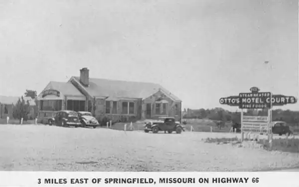
The original building has been painted and the rock finish is concealed by the paint. However it is clearly recognizable.
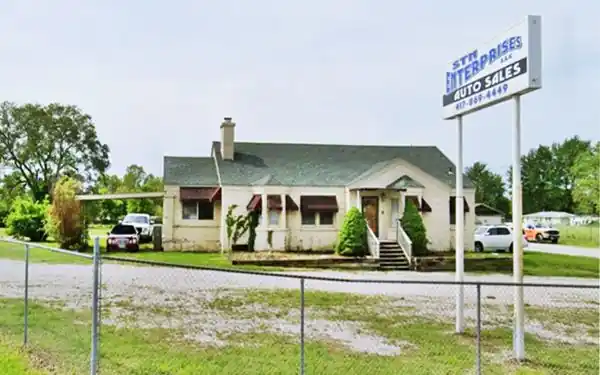
Drive 0.9 miles to U.S. 65, one half mile after the overpass at U.S. 65, to your right was the site of the stone cabins of "Lurvey's Court", torn down in July 2020. See the street view from 2019, before it was razed.
Holiday Drive-in Theater
Next to the now gone Lurvey's, at 2857 E. Kearney St. to your right. Pictured below.
Holiday Drive-in Theater on Route 66, Springfield MO street view
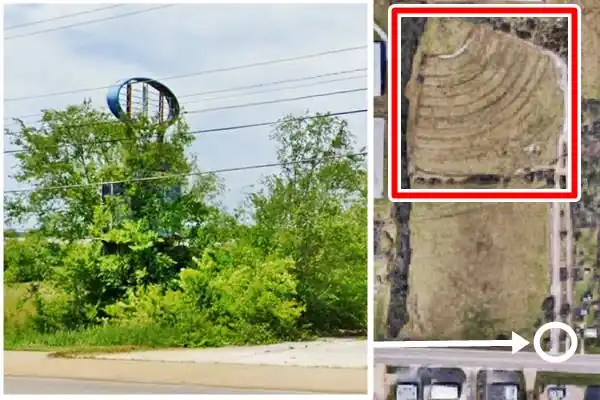
The image above shows the sign that is falling apart, and its location (white circle) in the satellite view and, to the north the old circular section with the now gone screen at its apex (red box).
It opened in the lat 60's and closed in the 1990s.
Drive west.
Rest Haven Court
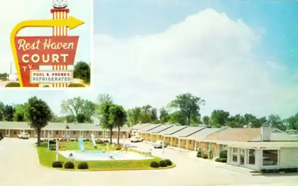
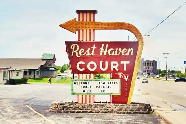
To your left, at 2000 E. Kearney St. The motel began as a service station in 1945 owned by the Brightwells. The first four stone cottages were added in 1947, each with two rooms. In 1952 they added 10 more rooms and ten more in 1953. The neon sign with a large yellow curved arrow is a classic; it was erected in 1955.
The vintage postcard proclaimed "Free T.V. in all rooms 100% Refrigerated Air-Conditioning - Steam Heat - Telephones - Beauty Rest Mattresses - Free Radios - Ice - Newspapers - Well Equipped Playground." In 1958 Route 66 was realigned to the north, along what is now I-44, that was when the pool was added. The couple retired in 1978, and the motel is still in operation.
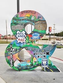
Ampersand sculpture, Springfield. Click for St. view. Source
City 66 was the road that went through Springfield's downtown area. Begin your trip at MO-744 on the eastern side of town, turn left along Glenstone southwards.
Ampersand sculpture
There is a 8 foot-tall and 7 foot-wide sculpture in the shape of an ampersand at a Kum & Go on the corner where Route 66 turns south along Glenstone Ave.
To the left of the store is an original Route 66 roadbed.
Original 1930 Roadbed
There is a section of the original 1930s Route 66 Roadbed on the SE corner of the intersection of Kearney and Glenstone. Here is where the road from
Strafford curved southwards towards Springfield along N. Glenstone. This is a map of the segment, 0.2 miles long.
Turn into N Glenstone Ave. On the SW corner of Kearney and City 66 is the site of the "Rock Village Court" mentioned by Rittenhouse. It was torn down; now it is an American Inn. Head south, and to your right, at 2209 North Glenstone is a classic motel.
White City Tourist Park - later Flagship Motel
Originally it was the "White City Tourist Park", built in 1927. It was replaced in 1959 by a more modern building ran by the Lurvey's, the Americana Motel; in 1981 it was renamed "Flagship Motel" and is still operating.
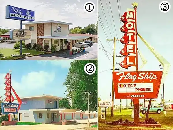
The image above shows the current appearance (1) of the Flagship Motel, it has the same same office and units as shown in the 1960s postcard (2) of the "Americana motel" (see large picture), however the great neon sign of the 1950s has changed, the original classic "Flamingo" neon sign (3) see full size image was adapted for the Americana but replaced by a bland modern one.
Glenstone Cottage Court
Head south, to your right, at 2023 North Glenstone Avenue is an old "auto court" that opened in 1947 with 14 units. Originally named "Black's Cottage Courts". It is almost unchanged as you can see in the "Then and Now" images below.
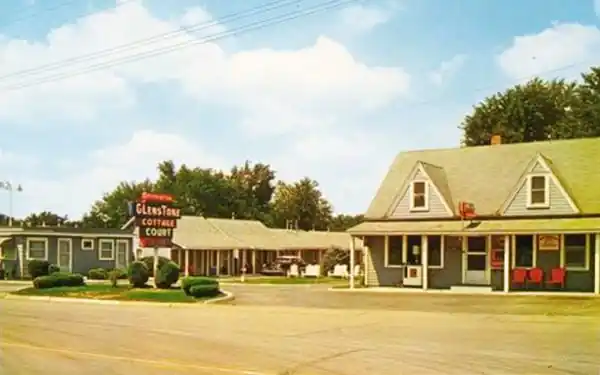
Glenstone Cottage Court nowadays
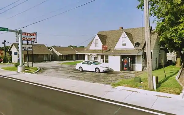
Dogwood Inn former Silver Saddle and Baldridge
Ahead, at 815 N Glenstone Ave. to your right is the former Silver Saddle Motel. Built in 1939, it was owned by John and Hazel Baldridge as the "Baldridge Motor Court". The place was reformed in 1957 and renamed as the "Silver Saddle Motel". It has been the "Dogwood Inn" since 1997. The "Then and Now" images below show its pool has gone, but the cupolas on the units' gable roof have survived.
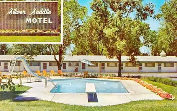

Drive south and at the intersection of S Glenstone Ave and E. St. Louis there are two gas stations, an old market an a classic motel.
Tydol Gas Station
To your left, on the NE corner is a gabled roof two-story building that was the "Glenstone Market" and gift shop from the 1940s (street view). Facing it, to your right, on the NW corner is what remains of a Tydol gas station, the two-bay service area (red arrows in the "Then and Now" images below).

1950s photo Tydol station, Springfield. Source
Sander's Service
On the SE corner of the intersection was Sander's Standard Oil Service Station.
The original building is still standing (red arrow in images) with the office and its two service bays.
The café to the left of the station in the 1950s picture was replaced by two large additional garage bays as you can see in the current view.

Manhattan Dinner House
The red-brick box-shaped building to the south of Sander's used to be "Manhattan Dinner House", serving supper daily 5 to 10 PM and Sundays noon to 10 PM.

Manhattan Dinner House postcard. Source
Rail Haven
At 203 S Glenstone Ave on the SW corner with E. St. Louis.
The place is now the Best Western Route 66 Rail Haven Hotel - Springfield. But it opened in 1938 with eight stone cottages as the "Rail Haven Motor Court".
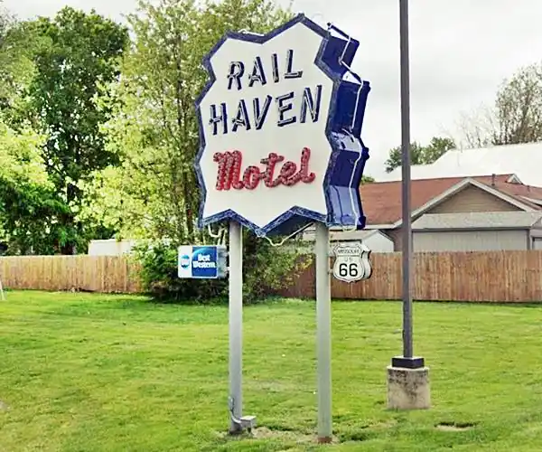
It was enclosed by a rail fence, which gave it its name (see picture further down). Its owner, Lawrence Lippman joined the Best Western hotels association in 1948. The old sign has been restored and relocated just west of the intersection, see image above.
Rail Haven Motel in a vintage postcard
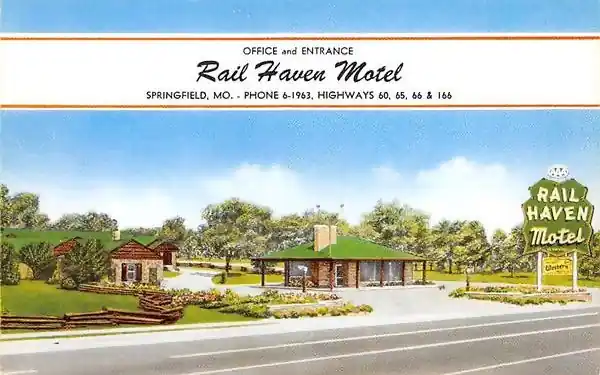
The image above looks northwest across Glenstone Ave. from Sander's station. The building next to the sign, with a stone chimney is still standing as you can see below (red arrow).
Burma Shave signs and Springfield neon arrow

Springfield neon arrow sign. Click for St. view. Source
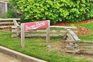
Along the sidewalk on E St. Louis you can see a set of red "Burma Shave" signs with white letters. Burma-Vita was a company based in Minesota. Starting in 1926 with the creation of the U.S. highway system they began to advertise their "Burma Shave" shaving cream using these red signs. They spaced them some hudred feet apart, and each sign had a few words, that combined with the text on the other signs formed a rhyme. These signs read west to east: "Listen birds - These signs cost - Money - So roost awhile! - But don't get funny - Burma Shave", and east to west: "This Will Never - Come to pass - A Back-Seat - Driver - Out of Gas - Burma Shave."
The Springfield arrow sign at the intersection also stood on the corner for decades and was torn down in an accident (02.12.1952) as you can see in the image.
Into Downtown Springfield
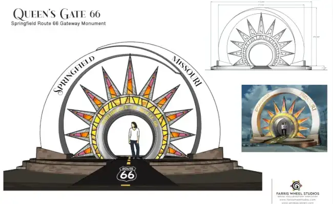
Springfield Centennial Gate
The city known as the "Birthplace of Route 66" is celebrtating ROUTE 66's 100th anniversary next year with a brand new monument. It will be located close to the Rail Haven Hotel, on land donated by the owner of the hotel! The monument will be 20 feet tall and 32 feet wide. The round opening in the middle will be 7 feet high.
Drive westwards along E. St. Louis towards downtown Springfield.
Springfield's "Carl the Chef" ❌
Relocated to Vinita Oklahoma now at Hi-Way Cafe and its Muffler Men
Carl the Cheff, is a "Muffler Man", Carl was located at the Route 66 Food Truck Park in Springfield MO, two blocks west of the Rail Haven, at 1530 E. St. Louis Street. Closed in 2022, auctioned in 2025, moved to Vinita Oklahoma.
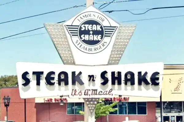
Steak 'n Shake
After 0.8 miles, to your left, on the SW corner of E St Louis St and N. National Ave.
This restaurant opened in 1962 on Route 66 and is one of the few original buildings that remains. This is a classic restaurant chain founded in 1934, despite the name there is no steak on the menu. They are "Famous for Steakburgers" originally made from ground T-bone, sirloin, and round steaks. The sign on the corner is a classic.
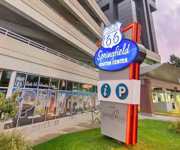
Visitor Center neon sign
Drive another 0.4 mi. To your right is the "Visitor Center" with a modern neon sign. A good spot to stop and find out what to see and do in town.
Kentwood Arms Motor Hotel
Just ahead, to your left, surrounded by a park, at 700 E St. Louis. The six-story "Kentwood Arms Hotel" was built in brick and sandstone in 1926 by John T. Woodruff.
It was the site of many National Highway 66 Association meetings. Now it is owned by the Southwest Missouri State University and used as student housing. Woodruff built it as a luxury hotel for Route 66 travellers. It had 100 rooms, rooftop garden, ballroom and beauty parlor.
The Abou Ben Adhem Shrine Mosque
Listed in the National Register of Historic Places
On the following block, to your right, at 601 E St Louis St.

The Abou Ben Adhem Shrine Mosque, Springfield MO. Source. Click for St. view
The "Shrine Mosque" was built in 1923 and belongs to the Abou Ben Adhem Shriners.
The five-story building is not a religious building, it is an auditorium that seats 4,000 spectators. It was named after the poem "Abou Ben Adhem" (May his tribe increase!) by Leigh Hunt.
The fraternal organization of the Ancient Arabic Order of the Nobles of the Mystic Shrine (A.A.O.N.M.S.), was founded in New York City in 1872 by Billy Florence and Walter Fleming, a physician.
Shriners are also a philantropic organization and the Shrine Center is used to host events and weddings.
Centennial Ozark Mural

Six-story mural. Source
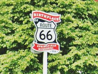
A six-story mural depicting the natural beauties of the Ozarks will greet those driving along Route 66 at Jefferson Ave and St. Louis St. as part of the centennial celebrations (St. view). Don't miss the Route 66 "Birthplace sign" on the corner.
Woodruff Building
Listed in the National Register of Historic Places
Across the street from the mural at 318 Park Central East, to your right, on the corner. This 10-story building dates back to 1910, Springfield's first skyscraper. It was the home to Missouri Court of Appeals and many law firms.
It was originally built in red bricks with ornate marble in its interior. After World War II it received a face lift (the blue porcelain panels date back to then).
In 2014 it was renamed "Sky Eleven" and is now an appartment building. Below is a "Then and Now" sequence.

Postcard of the Woodruff Building. Source
Birthplace of Route 66 Sign
John Thomas Woodruff, (1868-1949), attorney, businessman and promoter fo the Ozarks highways. He coined the expression "The crossroads of America" for Springfield, as both U.S. 65 and 66 intersected here. He built the Woodruff's Arms Hotel (1925) to cater to those travelling in cars (until then hotels seved rail travelers).
Gov. Fredercick Gardner reformed the state constitution to include a tax on gasoline to improve the roads and "Lift Missouri out of the Mud." Woodruff presided the Inter-Ozarks Highway Association which helped the ammendment get approved and later lobbied to get state highway 14 (later US 66) and highway 5 (now US 65) laid through Springfield. In 1926, Woodruff and Cyrus Avery founded the U.S. Highway 66 Association, Woodruff became its president.
The federal government had to number the new highway and the rule was that "the main transcontinental routes would be multiples of 10", so Avery wanted it to be Route 60, and initially it was named so. But the number was disputed by a highway following the historical National Roosevelt Midland Trail. The feds proposed Route 62 as an alternative, but Woodruff and Avery came up with number "66" and sent a telegram from Springfield to Washington: "Regarding Chicago Los Angeles road if California Arizona New Mexico and Illinois accept sixty six instead of sixty we are inclined to agree to this change. We prefer sixty six to sixty two." and it was approved; this is how Springfield became the birthplace of Route 66.
Gillioz Theatre
Listed in the National Register of Historic Places
To the left of Woodruff Building, at 25 Park Central E Springfield. It was built by M.E. Gillioz in Spanish style in 1926. Restored it reopened in 2006 (Visit their website).
It originally targeted Route 66 travellers driving right passed its front door. Built in an elaborate Spanish style on a very narrow property next to Woodruff Building.
Park Central Square
There is a plaque just to the right of the fountain (north of it), where Park Central E. meets the square (street view). It reads: "Springfield, Missouri. To commemorate the official birthplace of U.S. Highway 66 "The Main Street of America" 66th Anniversary 1926 - 1992. Placed by the Route 66 Association of Missouri."
A quick-draw shootout
Charles Butler "Wild Bill" Hickok former Union scout and spy got into a row over a gambling debt with Dave Tutt, a professional gambler which ended on July 21, 1865 in a shootout in which Hickok shot Tutt through the heart from a distance of 75 yards. He was tried and acquitted. There is a marker on the southeast corner of the square, on the roadway so watch out for the traffic! (street view).
Calaboose Old Jail
Drive round the square and head west along W. College St. Just ahead, at 409 W. College St., to your left is the old Jail.
Listed in the National Register of Historic Places
The old Jail is the oldest building owned by the city. Built in 1891, it was restored and now is a Springfield Police Department substation and museum. See its Street View.
Birthplace of Route 66 Roadside Park
Red's Giant Hamburg sign
Head west and drive 0.7 miles, to 1200 W College St. To you right, just past the intersection of S. New Ave. is the park.
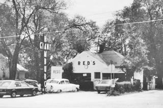
Original Giant Hamburg site. Source
The park was dedicated in 2014, and has a replica of Red's Giant Hamburg sign. This was a hamburger shop located on West Chestnut Expressway in Springfield (it opened in 1947 and closed in 1984). Said to be the first drive-through joint in the U.S. where customers picked the order at the kitchen window and did not have to wait for car-hops (waitresses).
The sign originally said "hamurger" but Red cut off the bottom letters "er", to mount it and avoid touching power lines. Another version says he miscalculated the sign's size and only "hamburg" fitted in the space.
"Mural" on Route 66
Across the street, is the Mural, (South side of 1200 W College St.) Dedicated in 2001, it is the work of local artist Christine Schilling, it has naive styled mosaics that commemorate Route 66.
Drive west. Ahead is the 1934 concrete slab bridge across Jordan Creek.
Route 66 Car Museum
1624 W. College Street, to your left. A collection of over 60 classic cars. Full details on the book and the movie. visit their website.
Rockwood Motor Court
To your left at 2200 College Street. This classic "motor court" was built and operated by Deverne Ruckman in 1929 -three years after Route 66 was created. He also built a Shell Oil gas station, house and café.
In 1948 it was named Rockwood Motor Court and has remained so for the past 72 years. In 2019, on its 90th anniversary, Phylilis Ferguson renovated it and it is once again operating as a Route 66 motel.
Don't miss the rock cottages in the rear part of the property; and see the "Then and Now" pictures below.
Historic Rockwood Motor Court in a 1940s postcard


Shamrock Square Motel
On the following corner, to your left, at 2300 College St. The motel was built in 1935 as the Shamrock Square Motel, it is still open (Shamrock Place), the neon sign is fantastic; a classic! It also has stone cottages in an L-distribution around the main gable roof office.
Historic Rock Fountain Tourist Court
Listed in the National Register of Historic Places
One block west of the Shamrock, at 2400 College Street. The nine rock cabins were built in 1945 by "Mac" MacCandless in the typical individual cottage style common during the 1930s. The Ozark sandstone faced the buildings giving them a stately appearance. At one time it had a real rock fountain now gone, that gave it its name -you can see it in the postcard below.
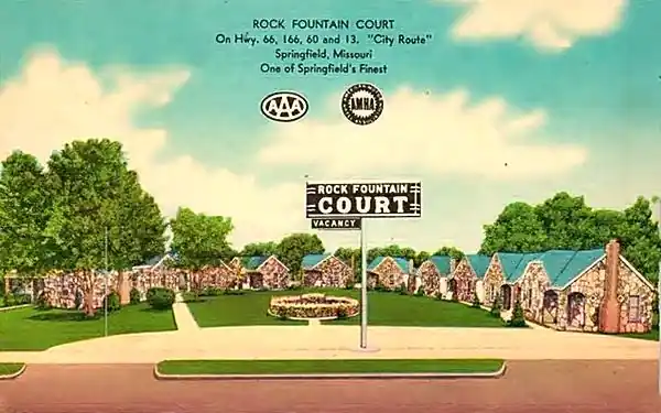
Now it is an apartment complex named Melinda Court Apartments. Private property and not open to the public.
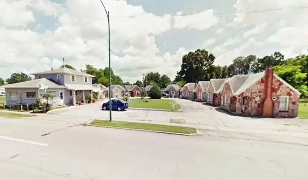
Site of Red's Hamburg
Drive West, ahead College St. curves and meets the Chestnut Expressway built in the 1960s to bypass the downtown area. Ahead is the site of the original "Red's Hamburg", it was torn down in 1997 (Street View).
City and Bypass Route 66 meet and head west
0.7 miles west, at W Chestnut Expressway and N West Bypass, both City 66 and Bypass 66 met.
Your Road Trip along City Route 66 across Springfield ends here.
We describe the sights and landmarks along Bypass Route 66 and Springfield west of this point on our Springfield Page 2. There is plenty to see in the city!
More Springfield attractions on the Next Page
We describe the rest of Springfield's attractions on Springfield Page 2

Sponsored Content
>> Book your Hotel in Joplin


Credits
Banner image: Hackberry General Store, Hackberry, Arizona by Perla Eichenblat
The Ramsay Place Names File
The WPA Guide to Missouri: The Show-Me State, 1939
Jack DeVere Rittenhouse, (1946). A Guide Book to Highway 66.

