Route 66 in western Texas
Index to this page
About Soncy, Texas
Facts, Trivia and useful information
Elevation: 3,820 ft. (1,160 m).
Time zone: Central (CST): UTC minus 6 hours. Summer (DST) CDT (UTC-5).
Soncy is now a neighborhood of Amarillo, it has been engulfed by the largest city on Route 66 in Texas. It is located on the souther limit of Potter County, in the central region of the Texas Panhandle.
It lies on I-40 and the old US 66 in SW Amarillo.
History
Read the history of neighboring Amarillo to learn more about the region's history.
In the mid 1870s William Henry Bush (1849 - 1931) came to the area in search of suitable land for his father-in-law Joseph Glidden, the inventor of barbed wire. He found suitable property and Glidden bought it, setting up his Frying Pan Ranch in 1881, and Bush was a partner in the enterprise.
The Fort Worth - Denver railway reached the area in 1887, just as Potter County was formed.
In 1898 Glidden transferred his ranch to Bush, who at that time was lobbying for the Chicago, Rock Island and Gulf Railway to acquire the Choctaw, Oklahoma and Texas line.
The takeover took place in 1903 and a railroad was laid from Amarillo to Tucumcari in New Mexico. Bush ceded the right of way through his ranch and gained an outlet for his production.
Bush and his associate S. H. Smiser platted two towns (Bushland, named after him), and Soucy, dedicated on July 6, 1908. His other associate, H. T. Trigg surveyed a townsite of five blocks by three. It had a school by 1910, grain elevator and a branch of Amarillo's post office.
Soncy
The name is of uncertain origin, but "Sonsy" or "Soncy" is Scottish for a person with pleasant, agreeable, engaging looks.

Where to Stay in Soncy
Neighboring Amarillo has plenty of motels and lodging optons, and so does Vega, to the west.
>> Book your Hotel in Amarillo
More lodging nearby along Route 66
The towns along Route 66 in Texas offer different lodging options. Check out some of the hotels and motels in the main towns below listed from east to west
In Texas Along Route 66
>> There are RV campgrounds in Soncy, and in neighboring Vega and Amarillo.
The weather in Soncy
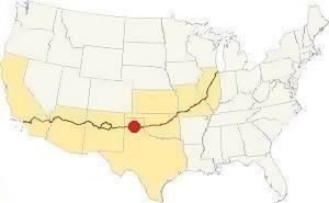
Map showing where Soncy is located on U.S. Hwy. 66
Rainfall averages 20 in. (500 mm); the semi-arid Panhandle region. Summers are hot, with average highs exceeding 9°F (30°C) amd average lows of about 64°F (19°C).
The average winter high temperatures are about 50°F (10°C) and lows on average are 24°F (-4°C).
It is quite likely that you will encounter Snow during wintertime (the first snowfall takesplace early December). Between 17 and 41 inches of snow can fall between September and May. (43 to 102 cm).
Tornados
The countryside around Amarillo is one of the windiest in the U.S., and it is also part of "Tornado Alley". Read more: Tornadoes on Route 66.
Map of Route 66 in Soncy
We divided the course of the highway across Texas into two legs, from Texola in the east to Glenrio on the NM state line. The midpoint of Route 66 is located in Adrian TX:
>> See this Interactive Map of US66 in Soncy.
See this Map of US66 in Soncy (before the four lane alignment was built west of Soncy). After the four-lane highway opened to traffic, Route 66 followed what is now I-40, and entered Amarillo along W Amarillo Blvd at Exit 62B.
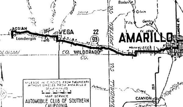
The map above shows the roads six years before Route 66 was created. Soncy is located under the "I" of Amarillo, on the right side of the map. Amarillo expanded and engulfed the surrounding communities as it grew in the late 1950s, and it absorbed Soncy.
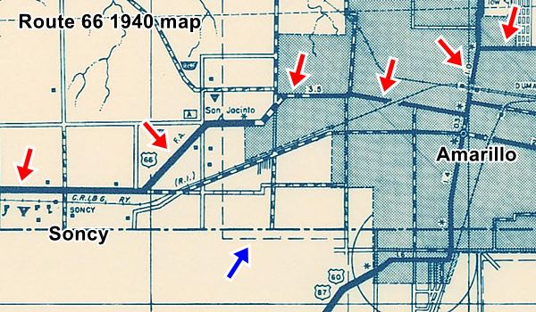
The following map published in 1936 shows the city limits at that time. The red arrows mark the alignment of Route 66 through Amarillo (from East, upper right corner) to Soncy in the West (lower left). This is the 1926-56 alignment. Notice how the dashed line (blue arrow) marks the "Corporate Limit" or city limit of Amarillo.
See the full sized map
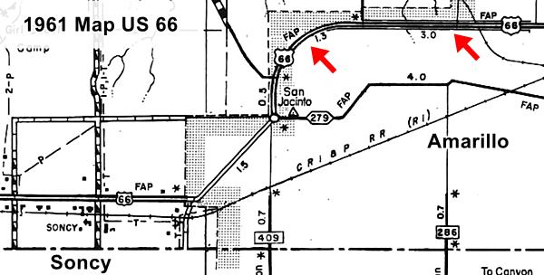
By 1961 Amarillo had grown and it now included the new Beltline 66 (red arrows in map below), but Soncy was not yet part of it. The dashed line with cross hatching marks the city limits (it cuts Route 66 at Coulter St. S, east of Soncy) at the point where its curve ends and it assumes an east-west course once again.
See the full sized map
Route 66 segments near Soncy
In the following webpages we describe each of the alignments near Soncy, in a dedicated webpage with maps, itineraries, and US66 attractions along the highway.
Alignment of Route 66 near Soncy
- Glenrio to Tucumcari (next)
- Amarillo to Glenrio (Soncy's)
- Texola to Amarillo (previous)
Route 66 Landmarks in Soncy
The classic sights in town!
Jack DeVere Rittenhouse in his 1946 "A Guide Book to Highway 66" wrote, describing the departure from Amarillo, to the west, as follows.
Pass a Veterans Hospital ( R ). US 66 makes a well - banked curve to the right, and at 7 mi ... you pass the UNITED STATES HELIUM PLANT ... The plant is operated by the U. S. Dept. of the Interior, and produces nearly half the world's supply of helium. During World War II it was heavily guarded. A gas station is nearby. Rittenhouse (1946)
The Veterans Hospital is still there, where The 1926-56 Route 66 heads west along 9th St. and meets the Beltline 66 alignment at Bell St. and the well-banked curve is at the southern tip of W Amarillo Blvd. as it curves into Soncy with an east-west course.
The helium plant has also survived. We will describe Soncy from east to west, starting at S. Soncy Road. Ahead, to your left, passing the Country Inn and Suites is a 1950s motel.
Arrow Motel
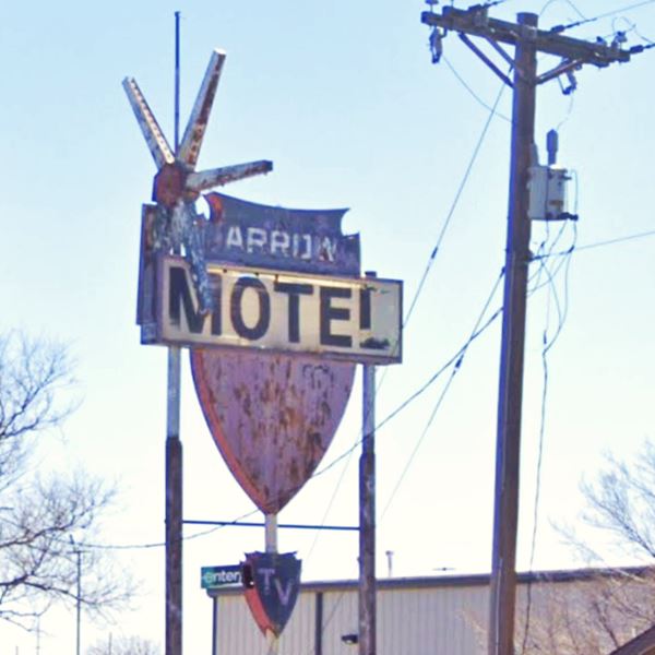
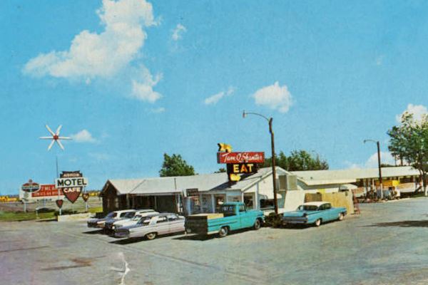
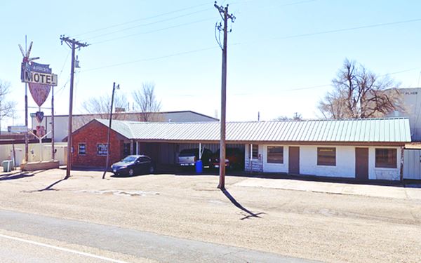
8975 W Amarillo Blvd. The Arrow Motel, according to the postcard below (posted in 1968), was "w Mi. West of city limits on U.S. 66, Amarillo... Equipped with panel-ray heat, carpeted floors...Restaurant adjoining. A clean, quiet place for a good night's rest. Owned and operated by Mr. & Mrs. O. E. Allen."
The neon sign is still there, but has been placed atop a tall set of posts with an eye-catching star next to it.
Head west, and as you approach the aptly named Helium Road, to your left is the historic Helium Plant mentioned by Rittenhouse.
Amarillo Helium Plant
At 9913 Hwy 66, south east corner of Helium Rd. and W. Amarillo Blvd., Soucy
Texas Historical Commission Marker
Helium: the gas
Helium is a chemically inert (does not react with other elements) gas. It is light and non-flammable. It is quite rare but produced naturally by radioactive reactions within the Earth's crust. The gas accumulates with other naturally occurring gases in gas fields.
It is used as an inert atmosphere for welding, medical uses, for blimps, and also for deep sea diving and on space missions for divers and astronauts (they breathe oxygen combined with helium, which is far less dangerous than pure oxygen).
Helium from the Cliffside gas field in Potter County was extracted by the U.S. government's Federal Bureau of Mines at the United States Helium Plant outside of Amarillo.
Bush provided 18 acres of his land in Soncy for the site in 1927. The plant operated between 1929 and 1970, and for years Amarillo was the sole producer of commercial helium in the world. By 1964, 95% of the world's helium was produced within 250 miles of Amarillo, the self-proclaimed «Helium Capital of the World»
It was also good for the local economy, over 500 jobs were created with the plant.
Historic Marker
The marker by the side of Route 66 reads: "Marker Text: This plant, operated by the United States Bureau of Mines, was the first to produce helium from the extensive helium resources in the Texas Panhandle. From 1929 until 1943, it furnished almost all of the world's supply of helium. Operating around the clock, the plant extracts helium by liquefying the natural gas and separating helium from it at temperatures 300 degrees below zero. The natural reserves in these fields and in extensions into adjacent states contain more than 95 percent of the world's known supply of helium. This is also the site of the world renowned research center which provides fundamental data on the production and uses of helium. Helium is used for a variety of purposes: lighter-than-air craft, low-temperature research, shielded-arc welding; and in national defense, nuclear energy programs and space exploration. (1965)"
Route 66

Route 66 Shell road map (1956) Soncy, large map
Ahead, passing the RV campground (it is decorated with four gigantic indian arrows - St. view), Route 66 alignment splits.
The original 1926 alignment headed west towards Bushland along Indian Hill Rd. There is a Brown Historic Route 66 sign marking the course.
The more recent 1950s alignment continued along Amarillo Blvd. and then ran westwards where I-40 is now located. It was a "superhighway" with four lanes as you can see in the map, from Amarillo, through Soncy and Bushland almost to the county line near Wildorado. The red arrow shows where Soncy is mentioned on the map.
Second Ammendment Cowboy
Cadillac Ranch RV Park
From Indian Hill Rd., head west along Amarillo Blvd. for 0.8 miles and at 2601 Hope Rd you will see the giant cowboy "muffler man" and the cadillacs. See this map with directions.
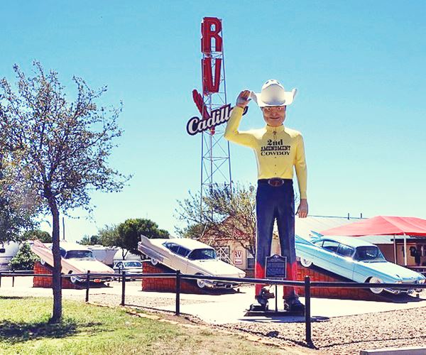
Glenn Goode owned a custom fiberglass company on Walnut Bend, in Gainesville TX. He recreated giant cowboys starting in the 1970s. He later made molds.
It is called the "Second Ammendment Cowboy" because it was used for target practice. Goode later repaired it.
It originally arrived to Amarillo in 2004 and stood by a restaurant until 2014, when it moved to its current location.
The 22 foot-tall cowboy wears a bright yellow shirt that proclaims he is the "2nd Amendment Cowboy", it has blue jeans and a Stetson hat. He is a Route 66 Modern Muffler Man.
The marker looks like a real Texas Historical Commission one, but it isn't. It reads: "2nd Amendment to the Constitution of The United States of America. A well regulated militia being
necessary to the security of a free state, the right of the people to keep and bear arms SHALL NOT BE INFRINGED.
A free people ought not only be
armed and disciplined, but they should have sufficient arms and ammunition to maintain a status of independence from any who might attempt to abuse them, which would include their own government. George Washington."
While you are here, don't forget to visit the three Cadillac cars. One is pink, another beige and third is blue. They are parked on angled Cadillac cars on wedges outside the RV campground.
Amarillo Ramp

Amarillo Ramp, Source
This "ramp" was supposed to be a circular jetty rising out of the water of a lake. The lake is now dry.
It is located on private land (Map with location) so visits should be booked at least one week in advance. Contact ar@holtsmithsonfoundation.org for details.
The Amarillo Ramp is the final creation of artist Robert Smithson (1938 - 1973).
It completes his trilogy of "land art" (Spiral Jetty -Great Salt Lake, Utah, 1970 and The Broken Circle, Emmen, Holland, 1971).
It is set on the now dry Tecovas Lake, 17 mi north of Amarillo. It was built with sandstone rock and is 148 ft. diameter (45 m) and rises over 15 ft. (5 m) above the lake bed.
Smithson was killed in a plane crash while surveying the location for this work. It was completed in 1974 by his widow, Nancy Holt, on a commission by Stanley Marsh (controversial local rancher well known for the famous Cadillac Ranch).
The dam failed years ago and the site is now dry. Grass and prickly pear cacti grow now on the earthwork.
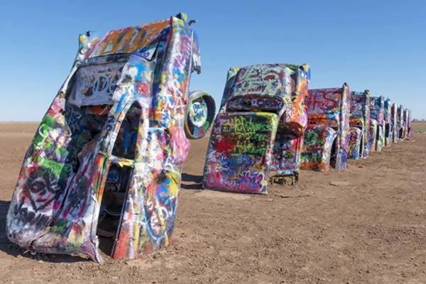
Cadillac Ranch
I-40 Exit 60, along South frontage road 2.4 mi west of Soncy.
We have a specific page with full information on the Cadillac Ranch.
Front view of the Cadillacs at Cadillac Ranch
This ends your tour of Soncy, head west to Bushland
Sponsored Content

>> Book your Hotel in Amarillo Texas

Credits
Banner image: Hackberry General Store, Hackberry, Arizona by Perla Eichenblat.
Route 66 maps Texas Historical Commission.
Paul H. Carlson, 208. Empire Builder in the Texas Panhandle: William Henry Bush. Texas A&M University Press.


