Ghost town on Route 66
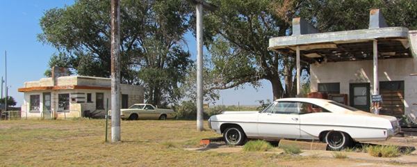
Vintage cars, a Route 66 diner, and gas station in Glenrio
Index to this page
About Glenrio, Texas & New Mexico
Glenrio's Facts, Trivia and useful information
Elevation: 3.850 ft. (1,174 m). Population: 0 (2025). Time zone: Central (CST): UTC minus 6 hours. Summer (DST) CDT (UTC-5) for the Texas part of town and Mountain (CST): UTC minus 7 hours. Summer (DST) MDT (UTC-6) for the New Mexico side of the town.
Glenrio is a ghost town that straddles the Texas - New Mexico state line; it is a Historic District listed on the National Register of Historic Places.
It is the first town on the old US Route 66 when entering Texas from the East, 73.1 miles (118 km) west of Amarillo; and it is the first "town" in New Mexico coming from Chicago.
It is unincorporated both in Quay Co., NM and Deaf Smith Co., TX. The formal location is Texas State Highway Loop 504 and New Mexico State Road 1578, both of which are actually the alignment of U.S. Route 66.
The Name: Glenrio
When the railway built the depot was named Glenrio but no reason was given.
Apparently the name combines two words of two different languages, just like it spans two counties in two different states: the English word "Glen", which is of Scottish origin, borrowed from the Gaelic word (gleann) which meant "mountain valley". Glen in English is "Narrow Valley", and the Spanish word "Río", which means "river".
So Glenrio is "narrow river valley". The only flowing water in the area is Trujillo Creek, one mile west, which flows north into the Canadian River.
There is a hill half a mile south of the town, right on the state line also called Glenrio (3,954 ft.)
By the way, the 1917 book "Railway Connections and Junction Points..." by Richard Henry Gray, writes it using two separate words: Glen and Rio (Glen Rio).
Glenrio's History
The Panhandle area has been inhabited for over 10,000 years. "Clovis" type stone tools of that age have been found 80 mi south of Glenrio, in Clovis NM.
In the 1540s, the Spanish "Conquistadors" explored the region searching for the mythical city of gold (Eldorado), but found only endless plains. The native Comanche and Kiowa Indians would live in peace until the mid-1800s.
White settlers began moving into the area after the U.S. defeated Mexico in the US-Mexican War of 1846-48 and incorporated Texas. The inflow of pioneers caused problems with the Indians, leading to a war (1874 - 76), their defeat and enclosure in reservations.
The townsite was established in 1905, when the tracks of the Chicago, Rock Island and Gulf Railway were extended west of Amarillo.
The station was built in 1906 and the local ranchers shipped their produce through the local depot. The station was in Texas, but the town spanned the state line into New Mexico.
Glenrio is part of Deaf Smith County. Erastus "Deaf" Smith (1787 - 1837), was born in Duchess Co., New York, and lost his hearing due to a childhood disease. He settled in San Antonio, Texas in 1821. He joined the Texas Revolution and fought, and was wounded in the war against Mexico. Sam Houston described him as follows: "A man, more brave, and honest never lived."
The New Mexican side of Glenrio had a post office but the mail arrived on the Texas side of the border.

Detail of a 1920 Road Map of Texas, USGS
Soon after the railway linked Glenrio with the rest of the country, cars began arriving. They followed the roads marked and promoted by the Ozark Trails Association (1913). The Glenrio Hotel began accommodating guests who arrived by car along the Ozark Trail. A dirt track mostly unpaved, muddy and dusty winding across the country.
The map in the image predates Route 66 and shows the Route 13 that preceded it; notice that Glenrio is written with two words: "Glen Rio". U.S. highway 66 was created in 1926 and it followed the alignment of Route 13, through Glenrio, becoming the bloodline of the town.
By 1920 the town had grown and had a hotel, cafes, stores and service stations it even had its local newspaper, the "Glenrio Tribune" (1910 - 1934).
The town weathered the Great Depression and Route 66 travelers contributed to the local economy.
Grapes of Wrath Trivia
There was a Texas Welcome Station by the state line, on the south side of the road. A non-verified myth says that it was a location of the 1939 film "Grapes of Wrath" (click on link for full details on the book and the movie).
By 1940 the population was 30. In those days Homer Ehresman, a local businessman, ran a service station, tourist court (motel), and grocery store.
Business was very good during the 1940s and 50s. But the old settlement south of the railroad vanishe. The school closed in the 1940s. and the railroad hotel was gone by 1945. US 66 was widened to a four lane highway in the 1950s.
But when I-40 was finished (1973), moving Route 66 out of town and bypassing Glenrio. It declined. The railway depot had closed in 1955, and business moved elsewhere: the Ehresmans went to Endee, NM, and Charles Jones relocated on I-40 in Oldham County. The railway and post office closed in the 1980s and by 2000 only five people lived in Glenrio. It had become a Ghost Town.

Where to Stay
The closest town to Glenrio with hotels is Vega:
> > Book your Hotels in nearby Vega
Lodging Near Glenrio along Route 66
The towns along Route 66 in Texas offer different lodging options. Check out some of the hotels and motels in the main towns below listed from east to west
In Texas Along Route 66
>> There are RV campgrounds close to Glenrio in Vega and Amarillo.
Weather in Glenrio

Where is Glenrio on U.S. Hwy. 66?
The weather in Glenrio is dry and sunny: rainfall averages 18 in per year (460 mm). Summer has highs (from June to September) that are above 90°F (30°C), and average lows of around 66°F (19°C), the average temperatures in winter range from 49°F (10°C) to 24°F (-4°C).
Snow falls during the period between September and May and is most frequent after December. The high terrain provokes greater snowfall (around 19 inches yearly with peaks that exceed 40”); 45 to 102 cm. The region around Glenrio is among the windiest in the continental U.S.
Tornadoes, this is Tornado Alley, some 6 tornados hit the county each year. Read more: Tornadoes on Route 66.
Map of Route 66 in Glenrio
We divided the course of the highway across Texas into two legs, from Texola in the east to Glenrio on the NM state line. The midpoint of Route 66 is located in Adrian TX:
>> See this Interactive Map of US66 in Glenrio in Texas, and this Map of US66 in Glenrio in New Mexico
See this Map of Route 66 through Glenrio.
Visit our Route 66 Map of Texas; it includes all of the alignments of US 66 in Texas and links to the towns along it for more information.
In the map below, Route 66 in Glenrio appears as an unpaved "graded road, drained and maintained. Usually bad during wet weather"
Route 66 (Standard Oil Co.) Map at Glenrio in 1937.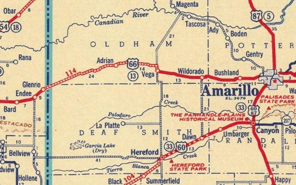
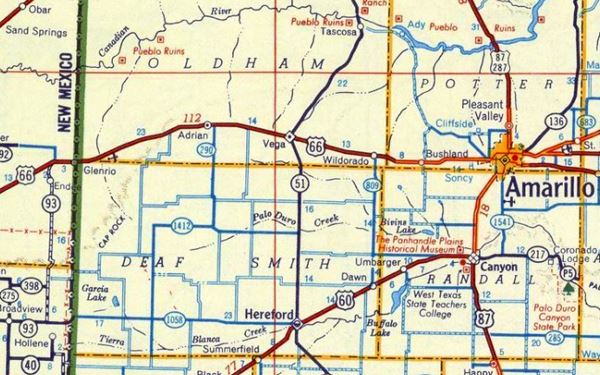
Below, paved highway in 1956 and, west of Amarillo almost to Wildorado, US 66 was a "Super-highway 4 or more lanes".
Route 66 (Shell) Map at Glenrio in 1956.
Alignment of Route 66
These are the sections of Route 66 in Glenrio. We describe each of them in a dedicated webpage with maps, itineraries and attractions along the way.
Glenrio's Route 66 Attractions
Historic Context
In his "A Guide Book to Highway 66", published in 1946, Jack DeVere Rittenhouse tells us about the town in its Route 66 heyday:
GLENRIO. (Pop. 84; store; gas; no tourist facilities.) This town is shown on maps of both Texas and New Mexico, possibly justified by the fact that the TEXAS - NEW MEXICO STATE LINE is located here, with the railroad station east of the on east of the line, but with all the business establishments west of it Rittenhouse (1946)
Town Attractions
As you leave the freeway there are two abandoned gas stations from the 1980s on the north side of the freeway. A former Chevron with the flat canopy and a Texaco, lacking a canopy.
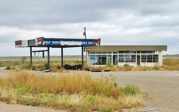
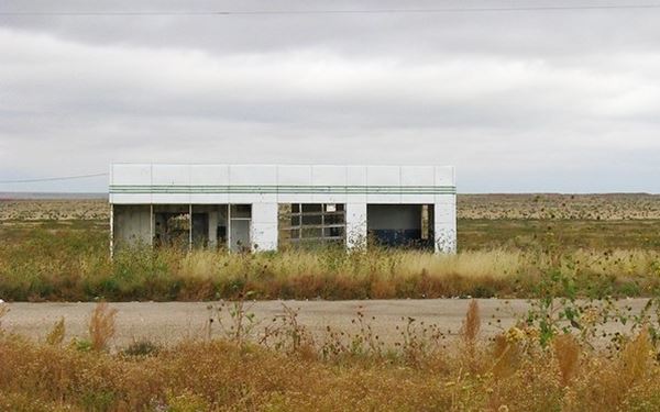
After leaving the freeway, head south and at the intersection with Historic Route 66, turn right. You are entering the Historic District.
Glenrio Historic District, Glenrio, Texas & New Mexico
National Register of Historic Places, Listed: 2007.
The Historic District is defined by Historic Route 66, Glenrio TX and NM.
The Glenrio Historic District encompasses not only the original Old Route 66 roadbed but preserves several vintage gasoline filling stations, motels and diners of the period when Route 66 was the main road through the Panhandle region of Texas, between 1926 and 1976; we describe them below.
Texaco Gasoline Station
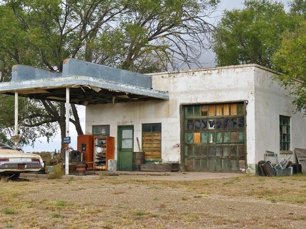
Drive west along Route 66. after 400 yards, to your right is the 19050 Texaco gas station.
With the classic streamlined moderne-style design on this 1950 building. Note the curved vertical panels on the upper part of the canopy.
New Mexico had a high state gasoline tax at that time, so the service stations that were there moved to Texas. At one time there were three filling stations in New Mexico: Broyles Mobil station (1925), Texaco (ca. 1935), and Ferguson Gas Station (1946).
Joseph "Joe" Brownlee, born in Glenrio, built the station and the adjacent diner in the 1950s. He also owned and ran the State Line Bar. His home, where he lived with his wife Roxie and his daughter Roxanne Travis was a 1930s bungalow that is still standing behind the gas station. It was moved to Glenrio from Amarillo and refurbished in 1950.
Roxanne Travis is the town's last real resident, she still lives in the old bungalow. Her husband was murdered during a robbery in 1976, while working at a now defunct gas station on US 66 in Adrian (Read newspaper article). And his white, rusting, 1968 two door hardtop Pontiac Catalina is still there, parked by the Texaco station in Glenrio.
The "Texas" Texaco gas station in Glenrio.
Little Juarez Diner
Adjacent to the Texaco, and also on the north side of US 66, is another empty building along the mother road, dusty, silent, remembering better days. It was a diner, the Brownlee Diner or Little Juarez Cafe (1952).
The diner is a box shaped building with a clear Art Moderne design. Take note of the rounded metal canopy, with horizontal lines or the curved tops of the walls, and the crest in the middle of the building, as well as the tips of the front wall; curved and streamlined.
Art Moderne or Streamline Moderne, was popular in the 1930s and evolved from Art Deco. Its main features are: curved shapes with rounded edges, horizontal lines or grooves in walls, flat roofs, smooth wall surfaces (plaster) and pale beige or off-white colors with contrasting dark trims.
Disney Pixar's animated film "Cars" (2006) included an abandoned building designed along the lines of the Little Juarez Café which later becomes a racing museum (see the Car's movie image) . It also portrays a vacant "Glenn Rio Motel". Homage to this historic town.
Little Juarez Diner, Glenrio, Texas
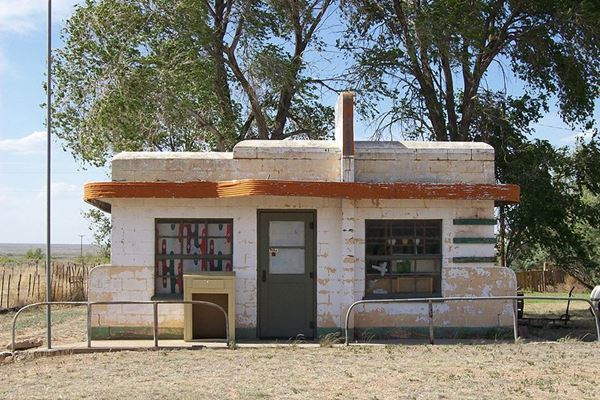
The St. view below shows both the diner and the service station.
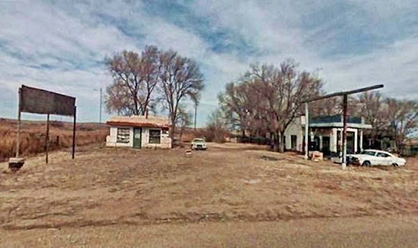
Longhorn Motel, State Line Café & Gas Station
Head west, 200 yards ahead, to your right is a complex involving a motel, a café and a former Phillips 66 gas station.
State Line Café & Gas Station
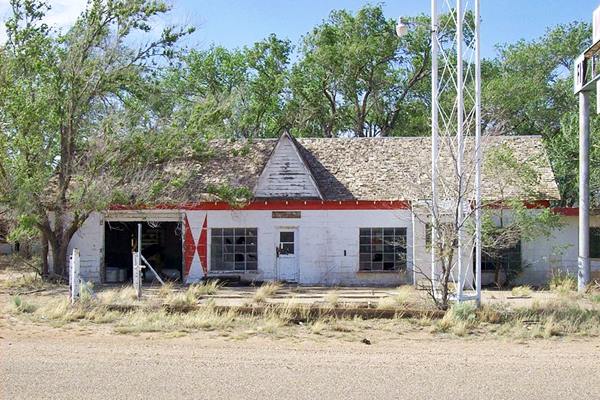
Built by Homer Ehresman in 1953 with concrete blocks and a gable shingle roof, it has the gas station with the garage bay is to the west and the cafe on the eastern side of the building. The eastern wing has a flat roof and served as the cafe.
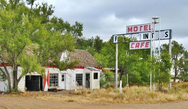
The red harlequin diamond painted on the wall and the steel pylon that supported the gas station sign are typical of a 1950s Phillips 66 service station.
Notice in the image below, the neon sign "Motel - First Motel in Texas - Cafe", the opposite side, facing east said "Last Motel in Texas".
State Line Café & Gas Station, Glenrio, Texas
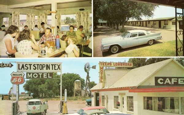
This postcard below shows the interior and extrior of the complex and includes the motel behind it. Notice the sign at that time -late 1950s was different and said "Last stop in Tex". The windmill and water tank in the background are still there, but the New Mexico state line to the right has gone.
State Line Café & Gas Station, Glenrio, Texas
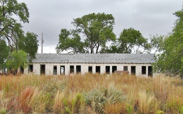
Longhorn, First and Last Motel in Texas

Ruins of the Longhorn Motel, Glenrio. Source
Immediately behind the cafe and station is the U-shaped thirteen unit Longhorn Motel built in 1955 by Ereshman. It remained open till 1976.
This motel was a kind of "Last Chance". Glenrio was 41 mi. east of Tucumcari, in New Mexico and 73 miles west of Amarillo, TX, a long distance for cars in the 1950s, especially cars lacking air conditioning during the hot summer months.
In fact, it is the last building in Texas, the border runs right against the motel's western wall.
It is in disrepair, overgrown, cracking ceiling, linoleum floor tiles peeling off, scattered remains of a happy past, when this town received, fed and comforted travelers on their way to California or Chicago.

State Line marker, Source
The State Line
50 feet west of the Longhorn Motel is teh border. Cross the border, leaving Glenrio in Texas and entering Glenrio in New Mexico.
To the right is a water tank and the remains of a windmill built in 1945, you will see the post that is the state line marker (pictured -red arrow).
State Line Motel
The first building to your right is the eight unit motel, that faces the highway. It was built in 1930 in adobe. It has concrete foundations and stucco covers the adobe. Each of the rooms had a window facing north.
The motel was owned by John Wesley Ferguson, who also owned the adjacent "State Line Bar", and Boyles Mobil Gas Station. (St. view of the three buildings).
State Line Motel, on the New Mexico part of Glenrio
State Line Bar

State Line Bar nowadays, Source
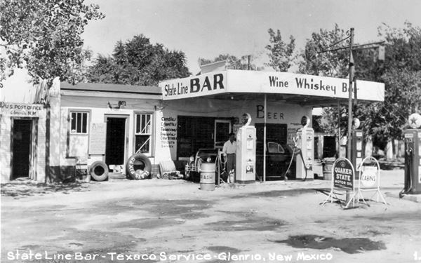
The box-shaped State Line Bar was built in New Mexico in around 1935 because Deaf Smith County in Texas was dry at the time. It belonged to John W. Feguson.
In 1960 it was remodeled. Concrete blocks were added to the facade that faces Route 66. This modified the original adobe structure which had a canopy over the pumps island of the Texaco gas station that was also part of the building.
On the western side of the building is a structure that once housed the post office.
Homer Ehresman bought the bar in 1939 and ran it for many years. He later sold it to Joe Brownlee.
State Line Bar in the early 1950s (Texaco service station), post office on far left.
Broyles Mobil Gas Station
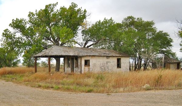
It is next to the bar. The station was built around 1925 by John W. Ferguston and later acquired by Jim Broyles who ran the Mobil service station.
It has a hipped roof with shingles that extends forward and serves as the canopy over the pumps island. It also has two outhouses behind it. One of them, the eastern one, dates back to around 1925 (one year older than Route 66), the other, to the west is from c.1940.
Route 66 itself
Route 66, originally a two-lane highway was widened in the mid-1950s through the town to accommodate the traffic. The New Mexico part of the segment included an concrete median to separate the westbound and eastbound lanes. This part of Route 66 hasn't been repaved since 1975.
Nowadays few cars drive this part of US 66. But in 1961, around 3,500 vehicles crossed the line between New Mexico and Texas each day.
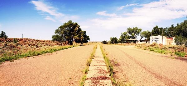
The image above looks west along Route 66. To the right you can see the "State Line Bar" and beyond, "Broyles gas station".
Head west for another 150 yards to visit the last "sights" in Glenrio.
Ferguson's Mobil gas station

Ferguson Mobil nowadays, Source
The station is a stark box-shaped building constructed in 1946 by J. W. Ferguson Jr. It was a Mobil gas station.
Built in concrete blocks, with an frame and adobe structure. It was also a post office (1986 photo).
Angel House built in 1910
Behind it is a stone structure built in 1910, the Oldest building in Glenrio, known as "Angel House". Ferguson used it in the 1930s and 40s to house the staff that worked at his businesses in town.
This ends your"city tour" of Glenrio.
Sponsored Content

>> Book your Hotel in Amarillo Texas

Credits
Banner image: Hackberry General Store, Hackberry, Arizona by Perla Eichenblat
Robert Julyan. 1996, The Place Names of New Mexico. UNM Press
H. Allen Anderson, "Glenrio, TX", Uploaded on June 15, 2010. Handbook of Texas Online, Published by the Texas State Historical Association.
Route 66 Glenrio, Texas Historical Commission.
The Route 66 through Texas Historic Report - Glenrio, Texas Historical Commission.
Jack DeVere Rittenhouse, (1946). A Guide Book to Highway 66.

