Route 66 in Bloomington IL
Index to this page
Bloomington Illinois
Facts, trivia and information
Elevation: 797 ft (243 m). Population 76,680 (2020).
Time zone: Central (CST): UTC minus 6 hours. Summer (DST) CDT (UTC-5).
The city of Bloomington is the county seat of McLean County in central Illinois. It is adjacent to Normal (they are the "Twin Cities" of Illinois) and their combined population is almost 130,000.
Bloomington, its History
Central Illinois' first inhabitants arrived about 11,000 years ago when the glaciers began melting at the end of the last Ice Age. During the historic period the Illinois and Kickapoo Native American people lived in this region.
French explorers and trappers were the first Europeans to reach Illinois from Louisiana and Canada in the early 1600s. They set up their trading posts along the wooded banks of the rivers, avoiding the prairies.
In 1781 the state of Virginia ceded its Northwest Territory to the U.S. government and it was organized into a territory. From this vast tract of land, the territory of Illinois was created. It became a state in 1818.
The first settler in what is now McLean County were John Dawson and John Hendrix in 1822, they were followed by the Funks in Funk's Grove and the Stubblefields in Mount Hope.
The Kickapoo continued living here when the first Europeans and Americans settled the prairies in what would become Bloomington, that was then known as Keg Grove (because the natives had found several kegs of whiskey hidden by the early settlers and taken them to their village).
Then it was renamed Blooming Grove apparently because Mrs. Orendorff said it was a good name because of the blossoms on the maple trees in spring. The post office opened in 1829 with that name. But by 1831 it had changed to Bloomington.
The name: Bloomington
"Blooming Grove" became Bloomington through an act of the Illiniois state Legislature. The lawmakers created McLean county and stated that the commissioners that it had appointed would meet and define the location of the county seat, and that "The seat of justice of said conty of McLean, shall be called and known by the name of Bloomington" (25.Dec.1830).
So the city was named and created before the town was actually founded!
It means the village "ton" in Old English that blooms.
McLean County was named after John McLean who had been a local pioneer lawyer, a territorial judge, the first Representative in Congress from Illinois (1818) and the United States Senator for Illinois (1824-1825).
A promoter of the new county donated 60 acres of land for the town and Bloomington was founded in 1831. However, progress was slow as the roads were bad and the plains vast, only after the completion of the Chicago, Alton & St. Louis Railroad through the area in 1853 did its population grow and its farms prosper.
U.S. 66 was aligned along State Hwy 4 in 1926 through Bloomington. In 1941 a "Bypass 66 " was built around the eastern and southern side of the town to ease the flow of traffic.

Hotels and Motels in Bloomington
Find your accommodation in town
>> Book your hotel in Bloomington
More Accommodation near Bloomington on Route 66
Below you will find a list of some of the towns along Route 66 east and west of this town; click on any of the links to find your accommodation in these towns (shown from east to west):
Along Route 66 in IL
- Hotels in Illinois
- Route 66 Starting point ▸ Chicago
- Lockport
- Willowbrook
- Bolingbrook
- Plainfield
- Romeoville
- Joliet
- Wilmington
- Dwight
- Pontiac
- Chenoa
- Normal
- Bloomington
- Atlanta
- Lincoln
- Springfield
- Raymond
- Litchfield
- Staunton
- Williamson
- Hamel
- Edwardsville
- Collinsville
- Troy
- Glen Carbon
- Pontoon Beach
- Granite City
- East St. Louis
West in Missouri
- Hotels in Missouri
- Florissant MO
- Bridgeton MO
- St. Louis MO
- Kirkwood MO
>> See the RV campground in Bloomington
The Weather in Bloomington
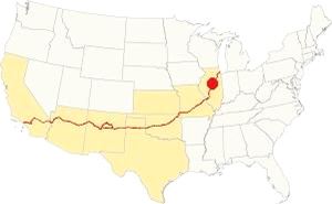
Location of Bloomington on U.S. Hwy. 66
Bloomington has a continental - humid climate with hot summers with little rainfall but high humidity. Its winters are cold.
The average temperatures for Bloomington are: winter (Jan), high of 30°F (-1 °C) and low a cold 17°F (-8.3 deg;C). Summer (Jul) is 85°F (29.7°C) and the low is 63°F (17.2°C).
Yearly rainfall is 38 inch (965 mm), falling 70 days, on average, every year. The town has 194 sunny days per year.
Expect snow between November and early April, it averages 26 inches (66 cm) yearly.
Tornado risk
Bloomington is located in Mc Lean County, which is struck by around 7 tornados per year.
Tornado Risk: read more about Tornado Risk on US 66.
Map of Route 66 through Bloomington in Illinois
>> Custom map with the alignments of US66 in Bloomington.
The old stagecoach route to Springfield was upgraded to a decent highway in 1915, the Pontiac Trail that was paved by 1923, becoming State Highway 4. In 1926 Route 66 was aligned along it.
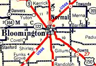
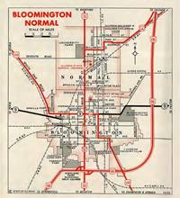
1936 IL DOT map of Normal and Bloomington, IL. Source
Click thumbnail map to enlarge
The original alignment ran along Main Street from Normal to Bloomington. The split into north and southbound traffic (now I 55 Bus.) along Main and N and S East streets (northbound) and S and N Center and Madison streets (southbound) only took place much later, in the 1960s. The block between Olive and Front was also open to traffic in those days. See the 1952 Sanborn map showing the original street layout.
As you can see in the 1936 map (click on it to enlarge it), U.S. 51 ran across the town from North to South along Main, and Route 66 left the town westwards after crossing the railroad by Bloomington's Depot, following W Oakland Ave, and then it turned south along S. Morris Ave (see the right angle turn marked with the blue lines by the "n" of "Bloomington".) On the SW corner, where it turned into Morris Ave. there was a gas station as you can see in this 1937-47 aerial photograph.
The 1926-38 Alignment out of downtown Bloomington is marked with a red line in our custom map.
Coming from the northeast, from Towanda it entered neighboring Normal following the course marked with an orange line in our custom map, it crossed Normal along Pine St. and had three right angle curves across the town and continued south together with State Hwy 2, later US 51 into Bloomington.
Its course is shown in our custom map witha violet line the 1926-40s and the later City 66 ran along Main St. with a north to south course, turning west along what is now Veterans Parkway.
Bypass 66
In the late 1930s the state and city officials decided to reroute the heavy US66 traffic around downtown Normal and Bloomington, by 1939 construction began and it finished at the end of WWII in 1945. We marked it with a white line in our map. There is a gap at its SW tip in Bloomington, at the exchange between I-55 and I-74 built in the 1960s. The original road became "City 66" as you can see in the 1955 map (click on it to enlarge).
The highway continues with a SW course into Shirley.
The Route 66 alignment in Bloomington
Visit our pages with old maps and plenty of information about US 66's alignments in this area.
- Springfield to Staunton IL (1926-30 US66) south from Springfield (next)
- Springfield to Hamel (after 1930) south from Springfield (next)
- Pontiac to Springfield (Bloomington's)
- Chicago to Pontiac (previous)

Sights and Attractions in Bloomington
Route 66 Landmarks and stops in Bloomington
Bloomington and US 66 in 1946
In his classic book, published in 1946 ("A Guide Book to Highway 66") Jack Rittenhouse gives a town by town description of Route 66 during its heyday, and of course he mentions Bloomington and its twin city, Normal are "virtually one community... city limits adjoining along one side" and tells us that "... US 66 skirts both towns completely, with a road west to the cities at the mileage point given..."
This tells us that he didn't enter the city, but drove around it using the "Beltway 66" that had been finished the previous year. He states that it was the town where the Republican Party was created in 1856 and provides details on lodging and garages:
... stores; Wannemacher's garage and Cherry St. Garage)... Hotels here include the Illinois, Rogers, Hamilton, Tilden Hall, Phoenix, Commercial... Rittenhouse (1946)
Lost Attractions
As is usually the case with Route 66's large cities, where change is the norm and urban renovation during the 70s razed many vintage buildings, all the classic motels have gone, none of the old gas stations on the Beltway survive, and only a few isolated places remain (for now) from US 66's golden days. The most recent losses were the Parkview Pub in 2016 (fire), and Quinn's service station in 2019 (razed).
Driving through Bloomington from North to South
Coming from neighboring Normal you will have to drive south along I-55 Bus (Central St.) which isn't the alignment of US 66. Until the early 1960s, Route 66 ran as a two-way street one block further east, along Main St.
We will mention the spots on Main. To visit them you can either drive into Downtown Bloomington and then head north along Main St. or drive south along Central St. and visit the spots on Main along the crossroads.
At Division Street you leave Normal and enter Bloomington. There was a service station on the SW corner with Main, it is gone (we used the Sanborn map of 1952 to identify the buildings that have been torn down.)
Casey’s Garden Shop
Illinois Route 66 Hall of Fame Inductee
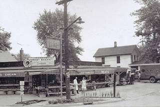
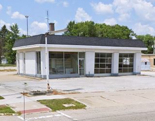
On Main, facing Kroger, at 1505 N. Main St. Eldon "Casey" Casebeer opened his fruit stand on the corner of Kelsey and Route 66 in 1949. His buisness grew into a 24-hour grocery store "Casey's Grocery Basket" with an ice cream shop catering to locals and those traveling along Route 66. Casey added a seasonal garden shop and flowers that eventually became the core business. He sold the grocery store in 1968. Shortly before his death in 1972 his daughter Alice Jayne and her husband purchased the seasonal garden shop. In 2021 it was bought by an employee and is still open. The image from the 1950s shows it (on the NE corner of Kelsey St.) this is the street view of the same spot.
On the next street, where the Walgreen's now stands on W Seminary and Main, there was a gas station in 1952. Also gone are the filling stations on the SW corner of W Scott and Main (check out the red-brick paving on Scott St.), the NW corner with W Empire and Main and the NE corner of Walnut St. and Main On the next corner is the site of Quinn's Station (gone, as it was torn down in 2019).
Quinn service station (Gone)
Illinois Route 66 Hall of Fame Inductee
The Holy Trinity Catholic Church across the street purchased the property in 2019 and razed the gas station to provide additional parking space for its congregation.
It was located on the NW corner of W Chestnut, at 802 N. Main Street, Bloomington.
It belonged to the Quinn's for over 70 years. Elmo A. and Eldon A. Quinn bought it in 1941. Elmo's son, Elmo C.J. Quinn worked here since he finished high school. He bought the business in 1978 following the death of his father and his uncle's retirement. In 1985 he switched to Shell gas. He ran it with his wife Eula until it closed in 2013 and they retired.
Elmo A., Eldon, Elmo C. J., and Eula Quinn were all inducted into the Route 66 Association of Illinois Hall of Fame in 2012.
It began in 1941 as a Texaco, with the modern style designed by Walter Dorwin Teague (a streamlined box). Elmo passed away at the age of 82 on March 22, 2023.
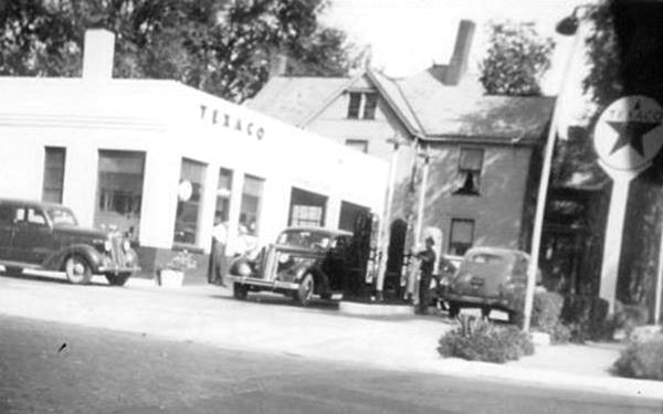
Former Gas Station
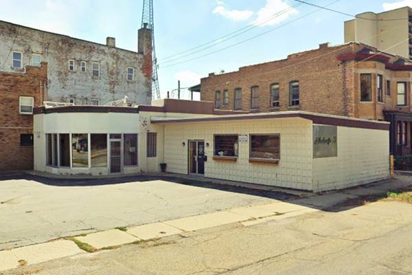
On the next corner, SW of W Locust Street (620 N Main) is a former Gas station in the 1952 Sanborn Insurance map.
Now it is a tattoo shop it is possibly the garage and gas station built by Thomas Evans for Clarence Irwin and Tim Hayes. It has a 1930s Streamline Moderne look with the rounded office design.
Historical Bloomington Central Business District
Listed in the National Register of Historic Places
Here the original two-way Main St. continued southwards. You will have to follow N Center St. which has the brown signs proclaiming it was Route 66 (though it wasn't from 1926 to the early 1960s). There is an archway across the street indicating you entered Historic Downtown Bloomington "Est. 1830."
Guitar Shaped Sign
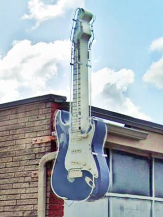
Don't miss the electrig guitar-shaped sign on the corner of N Center (525) and W Mulberry St. to your left. SE corner. Though not related to Route 66, it is an unusual sight (pictured). It is the sign of the Six Strings Club.
Ahead, on Market St. to your right is the Post Office Building, when it was built, Wannemacher's Garage mentioned by Rittenhouse in 1946, was torn down. It stood at 418 N. Center and its ads announced "Motorists Always Welcome at Our Garage matter what your trouble, are we can repair them. Complete Day and Night Auto Battery Charges Reasonable Satisfaction Guaranteed."
Lucca Grill
Turn left on Market St., cross Main, and on the next corner at 116 E. Market St is a classic restaurant in a building erected in 1908.
Two Italian brothers from Lucca, Italy, Fred and John Baldini opened it in 1936 and named it after their home town.
The bar was on the first floor and the restaurant upstairs on the second floor. It still makes thin-crust pizza. Enjoy its decorated tin ceilings and the mahogany bar. President John F. Kennedy once stopped here during his 1960 campaign. The building was completed in 1908
The building to its left (108 E Market St) opened in 1910 and was the Chatterton Theatre that later became the Illini Theatre. Closed in 1933 it is now a church.
llinois Hotel
Back on Central, head south. Rittenhouse mentioned the Tilden Hotel that was located one block west, on the NE corner of W Washington an N Madison; it was torn down.
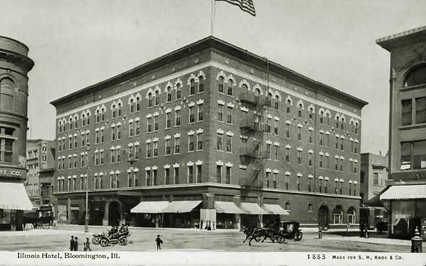
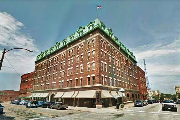
On the second block to your right, at 201 W. Jefferson St. is the hotel mentioned by Rittenhouse in 1946.
Designed by R.T. Newberry in Neo-Classical style to replace the old Windsor Hotel that had burned down. It opened in 1902 and became the Illinois Hotel with 180 rooms, restaurant, and all the ammenities. A sixth floor was added in 1925. The hotel was renamed the Ilinois House in 1961 and in 1972 became a residential and commecial building. Below is a "Then and Now" set of pictures.
Trivia: President Theodore Roosevelt slept here.
Illinois Hotel, vintage postcard (1902), Bloomington, Illinois
McLean County Museum of History
Listed in the National Register of Historic Places
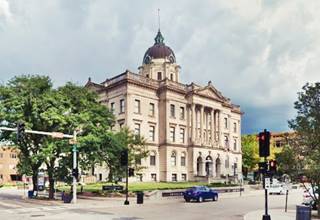
Opposite, on Bloomington's public square at is the old McLean County Courthouse built in 1903 in American Renaissance style.
"Cruisin’ with Lincoln on 66" Visitor Center
This is Illinois and Route 66 goes hand in hand with Abraham Lincoln. The Visitor Center is on the History Museum's first floor (200 N Main Street).
Phoenix Mid-City Hotel
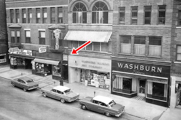
Half a block north along Main Street at 312 N. Main St. is the former Phoenix Hotel mentioned by Rittenhouse in 1946.
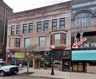
Dating back to 1902, it served as a hotel until 1965. Gaye Beck, its owner expanded her floral business and then in 2016 converted the former 44-room hotel into apartments. The bay window is still and the name "Mid City Hotel" is written on the entrance door's glass transom there but the hotel sign was removed.
Razed Early 1900s Hotels
Three hotels mentioned by Rittenhouse in 1946 in the southern downtown area have all been torn down:
Located between Main and Central, at 218 W Front, the Commercial Hotel was razed in 1971.
The Hamilton Hotel was torn down in 1988 and is now a parking lot. It was located at 310 E Front and was built in 1901 by Oscar C. Hamilton and Henry Dooley. It had 68 rooms and 10 apartments.
The Hotel Rogers, was a four floor red brick building on the NW corner of Grove and East Streets. It has been torn down.
Head west along S Center. The original Route 66 carried traffic in both directions along S Main St. There are two gas stations mentioned in the Sanborn's Insurance Map of 1952 the buildings have been repurposed but are still standing at 1210 S Main (St view) and 1501 S Main (St view).
Further south Center and Main meet. Here, to your left between Dunn Dr. and S Veterans Parkway was the Phil-Kron Drive-In Theater it opened in 1947 and was named for Ken Phillips and Peter Karonis, its owners. It could fit 800 cars and 400 walk-in customers. Behind the screen was a restaurant. In 1958 the place was renamed "Drive-In Theater" and the restaurant became the Sinorak Smorgasbord. It closed in the 1980s and nothing remains of it.
Head right along former Bypass 66 (S Veterans Parkway) at the curve, the highway meets the 1926-30s alignment along S. Morris St. nothing remains of the Route 66 buildings along the old alignment that ran along the western side of Forrest Park and Miller Park.
Forrest Park
At one time in the early 1920s it was a tourist campground. The early US 66 travelers woud picnic here and even camp out. Now it is a sedate city park with plenty of oaks and hickory trees.
Miller Park and Zoo
To your right. With its 1906 pavilion, a lake and war memorials plus a train (steam engine, caboose and coal car) from the Nickel Plate Railroad - New York, Chicago, & St. Louis Railroad Company that operated through Bloomington.
Parkview Pub
Ahead, to your left just past Folsom St. is the site of a vanished classic restaurant at 1003 S. Morris Ave.
Named so because it faces Miller Park. The pub was located on the 1930-40 alignement of Route 66 it has been here since 1928 making it the oldest restaurant in town to remain on the same site. It is also known as Parkview Inn and suffered a serious fire in 2016 and what survived was demolished and a new and bigger building was built and it replaced the old one. 2023 street view.
Continue your Route 66 Road Trip
This marks the end of this leg of your road trip in Shirley, head south to continue your journey and visit the next town: Shirley.

Sponsored Content
>> Book your Hotel in Chicago

Credits
Banner image: Hackberry General Store, Hackberry, Arizona by Perla Eichenblat
Jack DeVere Rittenhouse, (1946). A Guide Book to Highway 66.


