Route 66 in McLean IL
Index to this page
All you need to know about McLean Illinois
Facts, information & Trivia
Elevation: 708 ft (216 m). Population 730 (2024).
Time zone: Central (CST): UTC minus 6 hours. Summer (DST) CDT (UTC-5).
McLean is a village located on Route 66 in southwestern McLean County, Illinois.
McLean's history
There are Two McLean's on Route 66
The two McLeans are: this one in Illinois and the other other one in Texas: McLean TX.
Central Illinois was first inhabited some 11,000 years ago when the glaciers retreated north at the end of the last Ice Age. During more recent times, the Illinois people, who were Native Americans lived here on the plains and were the first to meet the French explorers in the 1600s.
The French were the first Europeans to reach this area, some were trappers others explorers or missionaries. The first settlers chose the wooded areas and the rivers as the plains were inhospitable.
After Virginia ceded the Northwest Territory to the U.S. Federal government in 1781, it was organized into a territory. Illinois was formed from that territory, becoming a state in 1818.
The first settlers in what is now McLean County were John Dawson and John Hendrix in 1822, they were followed by the Funks in Funk's Grove and Stubblefields in Mount Hope in 1824.
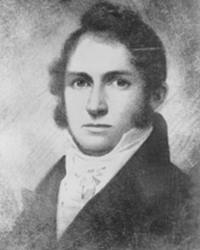
John McLean
Mount Hope township with the village of Mt. Hope was established in 1836, west of the future McLean, but it was unsuccessful.
McLean County was created in 1830 and named after John McLean (1791-1830) who had been a local pioneer lawyer, a territorial judge, the first Representative in Congress from Illinois (1818), and the United States Senator for Illinois (1824-1825).
McLean is the Anglicized form of the Sottish Gaelic name Mac Gille Eathain, which means "servant of (Saint) John".
Progress was slow as the roads were bad and the plains vast, only after the completion of the Chicago, Alton & St. Louis Railroad through eastern Mount Hope in 1853 were the railroad depot and village of McLean created.
Franklin Price from Pennsylvania founded the town in 1855 and by 1866 it had its first grain elevator and had incorporated as a village.
The name: McLean
Named for the county where it is located.
Route 66 was created in 1926 and aligned through the town, later it shifted a few blocks further east and finally as a Bypass 66 where I-55 now runs.
McLean's Hotels & Motels
Find your accommodation in town:
> > Book your hotel in neighboring Atlanta
More Lodging Nearby along Route 66
Below you will find a list of some of the towns along Route 66 east and west of this town; click on any of the links to find your accommodation in these towns (shown from east to west):
Along Route 66 in IL
- Hotels in Illinois
- Route 66 Starting point ▸ Chicago
- Lockport
- Willowbrook
- Bolingbrook
- Plainfield
- Romeoville
- Joliet
- Wilmington
- Dwight
- Pontiac
- Chenoa
- Normal
- Bloomington
- Atlanta
- Lincoln
- Springfield
- Raymond
- Litchfield
- Staunton
- Williamson
- Hamel
- Edwardsville
- Collinsville
- Troy
- Glen Carbon
- Pontoon Beach
- Granite City
- East St. Louis
West in Missouri
- Hotels in Missouri
- Florissant MO
- Bridgeton MO
- St. Louis MO
- Kirkwood MO
>> See the RV campground in neighboring Bloomington
The Weather in McLean
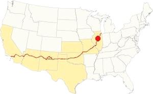
Location of of McLean, on U.S. 66 in Illinois
McLean has a humid continental climate: hot, humid summers and cool to cold winters.
The average high for winter (Jan) is 34°F (1 °C); the average low for winter is 18°F (-7.8 deg;C).
The summer average high (Jul) is 85°F (29.7°C) and its low is 65°F (18.1°C).
Precipitation is lowest in January (1.93 in. - 49 mm) and peaks at 5.08 in July (129 mm).
Yearly rainfall is 36.7 inch ( 1,008 mm). Snow falls from November through March and averages 22 inches (55 cm).
Tornado risk
McLean County is struck by some 7 tornados each year. Tornado Risk: learn more about Tornado Risk on US 66.
Map of Route 66 in McLean
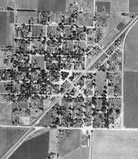
1940 aerial photo McLean IL. Source
Click thumbnail map to enlarge
The 1926-1940s alignment in McLean ran along the town's eastern side. At its southern tip it followed a different alignment to the current one: Old Route 66 didn't turn along former W Carlisle St. and S Main St as it does now, instead it continued straight and turned west at US 136 (former State Hwy 119), site of the Dead man's Curve (gone).
When I-55's Exit 145 was built, it disrupted the former alignment and it was realigned. Click on the thumbnail aerial photo taken in 1940 to see the original roadway. In our custom map with the alignment across McLean, US66's course is marked with a pink line.
The town was bypassed in the early 1950s with a 2-lane segment that is now under I-55's southbound lanes and marked with a green line in our custom map.
The Route 66 alignment in McLean
Visit our pages with old maps and plenty of information about US 66's alignments in this area.
- Springfield to Staunton IL (1926-30 US66) south from Springfield (next)
- Springfield to Hamel (after 1930) south from Springfield (next)
- Pontiac to Springfield (McLean's)
- Chicago to Pontiac (previous)

Attractions on Route 66 in McLean
Historic Context: McLean US 66 in 1946
Jack Rittenhouse published his "A Guide Book to Highway 66" in 1946 after driving the whole of Route 66. He has an entry for McLean in which he wrote: "... Van Ness Garage. Another small community, but it provides gas station and cafe."
Little has changed since then.
A Drive through McLean along Route 66
Head westbound from Funks Grove along the old Route 66 for this leg of your Route 66 road trip. After 2 miles, the freeway will appear to your left. Its southbound lanes overlay the former northbound lanes of US-66.
Benedict's Midway Standard Oil Station
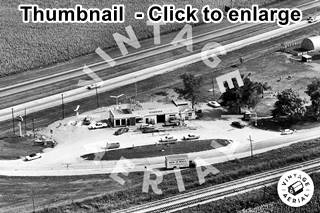
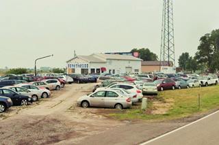
After another 1.5 miles, the freeway moves away from Route 66. Here was the fork where the 1926-50s alingment met the later "bypass 66" alignment that skirted the town (Now I-55). Benedict built his gas station here, and the building is still standing, though converted into a used car lot. Click on the thumbnail photograph to see a large sized view of it in 1966. In those days, the four-lane highway that carried I-55 and Route 66 wasn't the current limited access freeway, it had a grade crossing at this point. Below is the current view of the former filling station.
US 66 on the north side of McLean
The original Route 66 headed into town (0.8 mi south). The original State Highway 4, and the first Route 66 probably crossed the downtown area, but we have not been able to find any evidence showing this. What is certain is that by 1940, at the fork with N Fisher St. there was a gas station, Benedict's first location, as you can see in the aerial photo taken that year (click on the image to enlarge it).
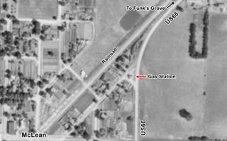
1940 aerial photo US 66 in north McLean IL.
Click thumbnail map to enlarge. Source
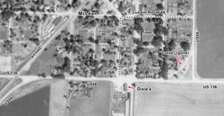
1940 aerial photo US 66 in south McLean IL.
Click thumbnail map to enlarge. Source
Route 66 on the South side of McLean
The original alignment of Route 66 ran straight southwards and curved west at its junction with U.S. 136 at Dixie Rd. See "curve" in the image (click on it to enlarge); this was the Dead Man's Curve of McLean. When the freeway was built, it altered this junction. Now a motel stands on what was the last block of the old US66 at the old "curve". The current alignment -dashed line in image- curves along Carlisle and S East streets, and you will drive this way. Signs with US66 shields mark the way.
Follow the current alignment of Route 66 to U.S. 136. Here at the crossroads there are several landmarks:
Illico Gas Station (gone)
To your left, between South Main and East St. was a gas station (300 Dixie Rd.); now it is an open lot (street view). The image below shows it in 1948, In the mid 1950s it became an Apco gas station. You can also see it on the right-center side of the 1950s image of Dixie's Truck Stop further down. The two businesses faced each other.
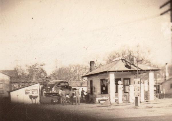
To your right, there are several structures on the NW corner of S. Main and Dixie Rd.
McLean Depot Train Shop
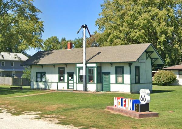
At the back of the lot is the Old McLean railway depot at 200 East Dixie Road. This is the original building of the railway depot that stood in central McLean on the old GM&O, Alton Route tracks. It is also one of only two stations still standing in Illinois that witnessed the 1865 funeral train that carried President Lincoln's coffin back to Springfield for burial.
It has been restored and now a is a visitor center and hobby shop selling all sorts of model railway kits.
On the eastern side of the building is a small monument with neat set of colored letters spelling "McLean", with a Route 66 shield (see lower right side of the image below).
McLean silhouette and sign
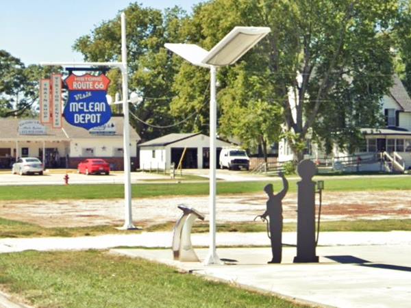
Turn west onto U.S. 136 & Historic Route 66. On the NW corner, also to your right is a steel silhouette of a gas station attendant beside a 1940s gas pump that represents the old Dixie Truck Stop that stood across the street. Next to it is a stainless steel roadside exhibit that tells about the old truck stop: Dixie's "A home on the road." There is also a nice blue and orange shield-shaped sign informing travelers of the Railroad Depot.
Dixie Travel Plaza
Inducted into the Illinois Route 66 Hall of Fame (1990)
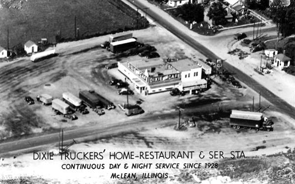
On the south side of Dixie Rd., to your left is the modern truck stop. It has a history almost as long as that of Route 66.
It is the oldest truck stop in the state. It began operating in 1928, just two years after Route 66 was created.
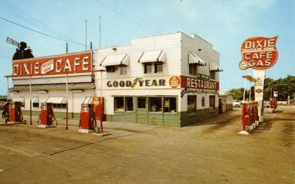
It was originally named Dixie Trucker's Home but over the decades it has changed names to Dixie Truck Stop and now The Dixie Travel Plaza.
John Geske and his father in-law J.P. Walters opened the Dixie Truck stop in a garage on the south side of Route 66. Soon they added a restaurant to feed the hungry drivers and later they added cabins and even a cattle pen to it.
Truckers and travelers were attracted by its family feeling and its great food.
Later Charlotte "C.J." Beeler (John's daughter) worked it with her husband Chuck Beeler. It only closed for one day between 1928 and 2003 -because of the fire that burned down the original restaurant building in 1965. They moved it to a cabin and rebuilt an even larger restaurant. The new building opened in 1967 and could seat 250. It included sleeping rooms, laundry and a barber shop.
It was a family run operation until it hit bad times in 2003 and was sold to a corporation; it is still operating.
Dixie Truck Stop in 1956, Four lane US66, McLean, Illinois
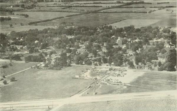
The image above looks north towards McLean; it shows Dixie's in 1956 (center); notice how it was linked to the 4-lane Route 66 (bottom) along the now cut-off continuation of South Main street. Nowadyas I-55 runs where the old 4-lane highway ran. You can see this same panoramic view in this current 3-D satellite image.
Dead man's Curve (gone)
Charlotte Beeler of Dixie's, is quoted mentioning the now gone death curve on Route 66 at its junction with U.S. 136; it is not mentioned often as it is in the shadow of the more famous Towanda Dead Man’s Curve. C.J. Beeler said:
It used to be called 'Death Curve' out here... It was just two-lane traffic. If you didn't slow down, you'd go off the road, or run into people head-on. C.J. Beeler (Source)
Continue your Route 66 Road Trip
Your tour through McLean ends here, drive straight along US 66 & US 136 and take the curve to the southeast by the railroad, following the Mother Road towards Atlanta.

Sponsored Content
>> Book your Hotel in Chicago

Credits
Banner image: Hackberry General Store, Hackberry, Arizona by Perla Eichenblat
Jack DeVere Rittenhouse, (1946). A Guide Book to Highway 66.


