Index to this page
- Illinois Route 66 Itinerary and maps
- Leaving Springfield along 1926 U.S. Highway 66
- The 1926 US66 alignment out of Springfield towards Chatham
- The historic Red brick section of Route 66
- Thayer
- Virden
- Girard
- Nilwood
- Turkey Tracks
- Carlinville
- Gillespie
- Benld
- Staunton
1926 Springfield to Staunton alignment
Illinois Route 66 Itinerary and maps
Each leg of Route 66 described below has an interactive map and many image maps so you can follow the alignments of the highway along the way:
- Chicago to Pontiac - Map of this segment.
- Pontiac to Springfield - Map of this segment.
- This leg: Springfield to Staunton (1926-30) - Map of this segment.
- Springfield to Hamel (1930-1977) - Map of this segment.
- Hamel to St. Louis - Map of this segment.
Missouri, next leg
The Original Route 66 between Springfield and Hamel
The 1926 alignments went through the cities listed below from Springfield to Staunton:
1926 US 66 in Illinois south of Springfield
< West - Staunton ¦
Benld ¦
Gillespie ¦
Carlinville ¦
Nilwood ¦
Girard ¦
Virden ¦
Thayer ¦
Auburn ¦
Chatham ¦
Springfield - East >
The Main Alignment of Route 66 (1930-77)
<West - Hamel ¦
Staunton ¦
Livingston ¦
Mt. Olive ¦
Litchfield ¦
Waggoner ¦
Farmersville ¦
Divernon ¦
Glenarm ¦
Springfield
- East >

Leaving Springfield along 1926 U.S. Highway 66
We describe the original alignment into Springfield from the north and the alignments after 1930 in our Springfield to Hamel (1930-77) webpage.
All of these alignments, from 1926 onwards, are shown in this Map of US 66 in Springfield (1926-77). The one marked wit an orange line is the 1926-30 one.
This is a map with directions of the 1926 - 1930 US 66 alignment in Springfield
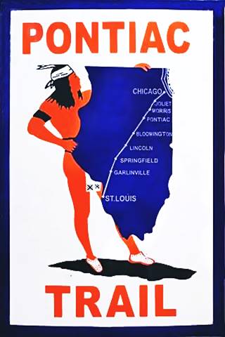
The Pontiac Trail symbol shield. A. Whittall
Historic background: Pontiac Trail
The predecessor of Route 66 was the "Pontiac Trail". The use of automobiles grew in during the early 1900s and this led to a public demand for better roads, suitable for cars.
Dirt trails used by horse-drawn carts with deep ruts, which became muddy traps during the rainy periods were unsuitable for cars.
A private association was formed in 1915 to promote the Pontiac Trail which would be built, and become a "solid surface road" linking Chicago with St. Louis. It was named for the famous chief of the Ottawa Indians.
The President of the State Highway Commission mentioned it in 1915 as part of the new legislation supporting state aid for highways (1)
The B.F. Goodrich tire company marked its milage posts with its custom shield sign (see image).
Auto Trails
Pontiac Trail was one of many "auto trails"; these were a network of routes that bore markers to identify them, usually a set of colored bands painted on poles or markers with numbers or symbols (diamonds, stars, letters, even a corn cob!).

1924 auto trails map south of Springfield. Source
Click on Map to Enlarge
They appeared in the first two decades of the 20th century and were mostly maintained by private associations. They were replaced in 1926 by the formal U.S. Highway System, but even before then, state highways had been built along some of them.
Route 66 ran along two famous trails, the Ozark Trail and the Santa Fe Trail.
The map below shows the auto trails south of Springfield in 1924.
Illinois State Highway 4

Creation of State Hwy. 4, Illinois (1919) Source
The call to "Get Illinois out of the mud" was promoted by state representative Homer J. Tice. His first bill to improve highways dates back to 1893. He succeded with the "Tice Act" of 1913 that established the funds and responsibilities for builing and maintaining decent "hard roads".
The state government took over its responsibilities for building good highways, and issued a bond in 1918 that created the State Bond Issue highway 4 (or SBI-4) which mostly followed the original Pontiac Trail.
State Route 4 ran all the way to East St. Louis, but didn't start in Chicago. It began in Cicero, the first town west of Chicago.
The text (see image) gives us its starting point: "ROUTE No. 4. Beginning at the intersection of 48th and Ogden Avenues in the Town of Cicero, Cook County, and running in a general southwesterly direction to East St. Louis...."
This highway south of Springfield had a winding course following the former county lanes and lot demarcation trails. It had many sharp 90° curves. This made it unsafe and also longer.

1929 roadmap south of Springfield. Source
Click on Map to Enlarge
This highway was paved between 1923 and 1926, and that same year, 1926 when U.S. Highway 66 was created, it was aligned along the new IL-4 roadbed. Initally Route 66 and State Bond Issue (SBI) 4 overlapped until the signs of the old state higway were finally replaced by the U.S. 66 shields in 1927.
1926-1930 US 66
From the start, the Illinois Division of Highways headed by Thomas Sheets had sought a straighter highway south of Springfield, and Sheets wrote an article in the state's 1924-24 Blue Book proposing "Route No. 126.—Beginning at Springfield and extending in a southerly direction to Litchfield, affording Springfield, Divernon, Waggoner, Litchfield and the intervening communities reasonable connections with each other." As soon as Route 66 was aligned along IL-4, plans were drawn to realign it along IL-126. The 1929 roadmap (click image for full sized map) shows that work began in 1928 and by 1929 The old IL-4 state highway was marked also as "T 66" ("temporary 66") while the construction work along former state highway IL-126 continued and part of the new US 66 alignment had already been built and paved along it: in the south to Litchfield and Raymond, and in the north to Glenarm.
But let's focus on the original Route 66, and follow its alignment soutwards from downtown Springfield.
The 1926 US66 alignment out of Springfield towards Chatham
Leaving Springfield
The first alignment is marked with an Orange line in our customized zoomable map of Route 66 in Springfield (see below) you can also see it in this map with directions.
>> orange line in custom map shows the 1926-30 US 66 leaving Springfield.
As you can see it has many sharp 90° turns as it zig-zags its way across Southwestern Springfield.
Two alignments at Woodside Rd.
When Route 66 reached Woodside Road, it curved towards the SW to cross Lick Creek and head towards Chatham (below is one of these two alignments, it is the original highway forking from Woodside Rd.)
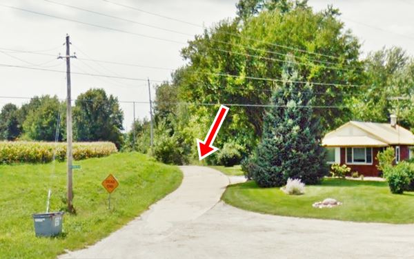
The second alignment is further east, and more or less parallel to the original one.This newer roadbed was cut off from Woodside Rd. when the new IL-4 highway was built in 1975 along Veteran's Parkway. There is a surviving segment that can be driven (see map with directons) and a gap of the missing segment:
>> pale blue line in custom map shows the driveable section. Black line: gap.
Below are two USGS maps showing this spot:

1924 USGS map of Lick Creek , Chatham, Il

1961 USGS map of Lick Creek , Chatham, Il
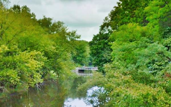
Lick Creek Bridge
Built in 1919 with a brick deck, it is also known as the Old Chatham Road Bridge or Schuster Bridge:
Route 66 at Lick Creek Bridge in Chatham, Illinois
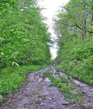
Abandoned US 66 south of Lick Creek bridge, Chatham, Il. Source
Kirtland's Snake
This area is a natural preserve, and is also the habitat of an endangered snake, the Kirtland's Snake (Clonophis kirtlandii), an endangered North American species of nonvenomous snake with a geographic range that spans Illinois, Indiana, Ohio, southern Michigan, western Pennsylvania and north Kentucky. It likes to live close to water.
On the south side of the river, the road was abandoned. It headed to what it now Veteran's Pkwy with a NE to SW course.
>> black line in custom map shows the gap west of Lick Creek.
Across Chatham
To continue your trip return to Woodside turn left and head west. Turn left again to head south along Veterans Parkway into Chatham (3 mi)
The highway went along Main Street to cross Chatham turned right along West Walnut to turn again, left, southwards along Church St.
The curved section of modern IL-4 between W. Spruce and S. Church wasn't built until the late 1930s.
>> violet line in custom map shows US66 in Chatham and beyond.
Original 1926-1930 alignment Chatham to Red Brick Road
The 4.6 mile trip from Chatham to the Historic Brick Road just north of Auburn is shown in this Map with Directions.
The first part is marked with a violet line in our custom map runs straight, almost parallel to the old railroad tracks to the left (east) it has a soft curve westwards into Alpha Rd. Where the 1926 alignment differs from the current one:
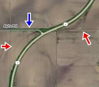
it used to run west along Alpha Rd. for 1000 ft. and then turn sharply south with a 90° curve along a now removed road segment. You can see the missing segments here in our custom map:
>> black line in custom map shows the gaps at Alpha Rd.
An aerial photo from 1956 shows the missing roadbed.
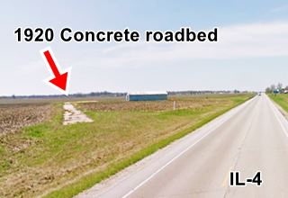
Below is the 1924 USGS map of the road and its present satelite view, the red arrows show the now abandoned sections. The dashed blue line is the present alignment built in 1932, and the blue arrow is the surviving concrete roadbed.

Historic Concrete Roadbed USGS Map 1924, Auburn, Il.
South of this point the highway curves, but as it reaches Hambusch and Snell Roads there are some remnants of an abandoned stretch of highway to your right.
>> brown line in custom map shows US66 from Alpha to Snell Rd.
An abandoned concrete section 1926 US66
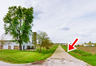
It is 1280 feet-long with a straight section on the north, and a curve towards the west onto Hambusch Rd.; this part is cracked and lies abandoned in a field.
The remaining section along Hambusch Rd. is driveable.
it was built in Portland Concrete in 1921 and had two eight-foot-wide lanes, narrow by our standards but common in the 1920s. This section is not part of the "Historic Place" that comprises the Brick Road further east. It just lies, forgotten, in a field.
It was indeed part of the 1920 Route 4 and then the 1926-30 US 66. The later 1930s straighter alignment of IL-4 still in use bypassed it. But it remained in use for some time and survived until the mid 1990s (1946 aerial photo see left side).
>> blue line in custom map shows the abandoned roadbed. Green: can be driven.
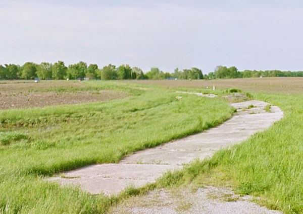
Ahead Hambusch Rd. meets the later Route 66 and continues westwards as Snell Rd. Just ahead is the historic brick road segment.
The historic Red brick section of Route 66
Listed in the National Register of Historic Places
See this map with directions along the brick segment.
>> red line in custom map shows the Historic Brick Roadway.
Route 66 was realigned further east via Litchfield and Mt. Olive, removing it from the old IL-4 alignment because the original concrete course had far too many dangerous sharp ninety-degree turns and sharp curves.
Red brick Route 66, Auburn Illinois
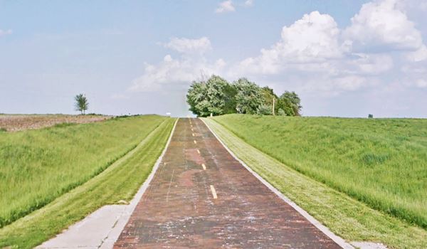
In 1932, during the Great Depression, old State Highway 4 was upgraded and improved. The roadway was widened beyond its original 16 feet, and many of the sharp 90° curves were eliminated.
The Auburn segment was also modified: its western part along Snell and Curran Roads was resurfaced with red bricks and the sharp curve at their junction
was softened into a wide arch (1)(2)
>> purple line in custom map is the old 90° corner replaced in 1932.
The image below shows a detail from the 1924 USGS map of Snell Road north of Auburn and the solid red line marks what in those days was State Highway 4; notice the sharp curves to the right and left (east and west).
The northern part was straightened (red dashed line) bypassing the eastern 90°curve at Hambuch Rd mentioned further up.
The new straight alignment turned right onto Snell Rd. which was paved with bricks, a soft curve was added at Curran Rd., and this road was also surfaced with bricks.
The current alignment of IL-4 south of Snell Rd. marked with a dashed blue line with a diagonal course from right Snell to Curran Rds. was not paved until the 1960s; it does not appear in any aerial photograph of this spot (see this 1956 aerial photo as an example) until 1971.
In the 1956 aerial photo you can see the original 1920s sharp curve at Snell Rd. and Curran Rd. (upper left side of image) and the red-brick wider curve built in 1932.

USGS map from 1924, Auburn, Il
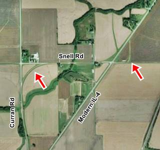
The image above shows a curent view of the same spot. The ninety-degree curve on the right (east) is the original 1920s concrete-paved segment between modern IL-4 and Hambuch Rd (red arrow) replaced in 1932. The red arrow to the left is the red brick road's wide curve.
> Read more about Brick paved sections of Route 66.

Auburn and its missing road segments
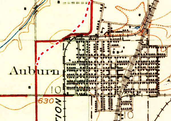
The highway continues south into Auburn but in the 1920s the town had a different configuration: The tracks of the Illinois Traction ran around the town, on its northern side along the south side of what now are Interurban St. and the East-West portion of Lincoln St. Then it curved south along the eastern side of what is now Redbud Lane.
So Route 66 followed Lincoln St. on its north to south portion and then turned west just south of modern IL-4 along the east-west section of Lincoln St. then it followed the NE-SW course of modern IL, but instead of curving south again as it does now, it continued westwards along a now eliminated extension of W. North St. then it turned sharply south along Panther Creek Rd. tp continue south on IL-4 all the way to Panther Rd.
>> gray line in custom map shows US66 across Auburn to Panther Rd.
This 1946 aerial photo shows this alignment.
1926 USGS map of Auburn IL, Route 66 is the red line on the right side. Dashed red line marks current IL-4
Panther Rd
Another set of consecutive right angle turns were eliminated at Panther, Ackerman, and Tiller Roads. The alignment in 1926 (map) changed into a soft "S"
>> blue line in custom map shows the two 90° turns at Panther Rd.

Thayer and Virden
Thayer

1924 USGS map of Thayer Il.
After the two sharp turns at Panther, Ackerman and Tiller, the original 1926-1930 alignment from Auburn to Thayer entered the latter along Harrison Ave. and W Sycamore St. with a sharp set of 90° turns on the south side of Thayer. The red line in the image map show this alignment.
During the 1932 upgrade IL-4 was made straighter by bypassing Thayer along its western flank.
>> teal line in custom map shows the Thayer and Virden US66.
Virden
Then it ran straight south into neighboring Virden
On the south side of Virden Route 66 followed the old IL-4 west along W Loud St for nine blocks and then it turned sharply south along S Wrightsman St. till it met the C. B. and Q. railroad.
It had a grade crossing with an acute angle that made it unsafe (eliminated later -black line in our custom map). The 1932 alignment instead curved softly out of southern Virden, crossed the tracks almost at right angles and then curved south again.
>> black line in custom map shows the eliminated railroad crossing.
Old Route 66 continued south after the tracks and then turned sharply west along Crown 2 Mine Rd. to turn, for the 4th time since downtown Virden, to head south once again.

1931 USGS map of southern Virden Il.

Girard
From Virden to Girard, the original State Highway 4 - Route 66 ran in a straight line into the business district of Girard (brown line in our custom map) where it took a different course to its current one.
>> brown line in custom map shows US66 north of Girard.
>> pink line in custom map shows Route 66 from Girard to Nilwood.
It turned west (right) on Madison and then south (left) along 6th Street. When it reached the railroad tracks south of town, it continued straight (the later 1930s IL-4 ran south till it met the tracks, and then took a NE-SW course into Nilwood.)
Route 66, Girard to Nilwood (1919-1931)
Listed in the National Register of Historic Places
This was a period of transition from cart, horse and mule to truck and cars. The old dirt track was replaced by a state of the art highway (by early 1920s standards): it was a concrete highway that had two eight-foot wide lanes and gravel shoulders 7 feet wide. The Portland concrete slab was 6 inches thick.
The original Illinois Route 4 in this area was paved between 1920 and 1922, it followed the former county lanes and lot demarcation trails and therefore had many sharp 90° curves.
This made it unsafe and also longer.
The pink line in our custom map shows how it zig-zagged its way across the farmland crossing the railroad three times! Also see this map with directions.
Old Historic Route 66 running through corn fields between Girard and Nilwood
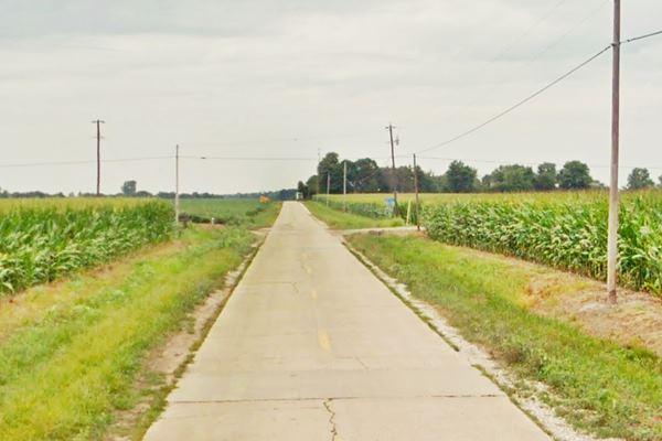
It has survived the wear and tear for 100 years and although it has cracks, it still has its original concrete paving plus the concrete box culverts.

Nilwood
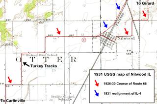
Old State Hwy 4, and the 1926-30 Route 66 entered Nilwood from the northeast along Old Hwy 4 and Pine St. it took a sharp turn to the right along Morean St., crossed the railroad with a grade crossing in the town's business district, and then, on its western side curved and adopted an east-to-west course. The image map (click on it to see it full sized) shows this alignment on the upper left and center -red arrows. Then it took five 90° turns ("stair-step dogleg") before heading south towards Carlinville. After Route 66 was realigned further east, in 1930, this highway became IL-4 and was straightened out gradually (blue arrows) to its current course.
Our custom map marks the 1926 alignment west of Nilwood all the way to Carlinville:
>> green line in custom map shows US 66 from Nilwood to Carlinville.
Turkey Tracks

Turkey Tracks sign, Nilwood, Il. Source
Wacky Route 66 attractions
At Donaldson Rd. (Old Route 66) Nilwood. This is a map marking where the tracks are located.
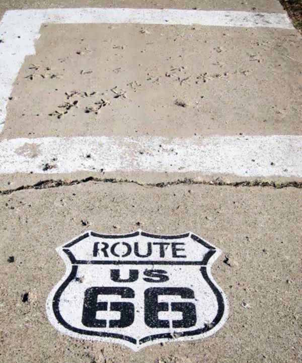
You will see the tracks on the left (eastern side of the road), there is a sign marking the spot (image) and a white square on the road surface to mark the spot. You can't miss it!
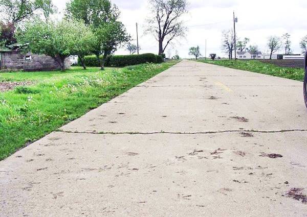
Below is a photo of the "turkey tracks", imprinted in the wet cement by a turkey (or group of turkeys) that walked across the roadway when the highway was built back in the early 1920s.
When were the turkey tracks made?
These tracks predate Route 66 (created in 1926) because they were made when Illinois Route 4 was paved in concrete around 1919 to 1921 so Thes track prints are over one hundred years old.
We know that it was already paved by 1921 because a contemporary article tells us that "To Carlinville the pavement is all laid with the exception of a short stretch at Thayer... from Carlinville to St. Louis the concrete is all laid..." (3).
Wild turkeys or domestic ones?
The only wild turkey found in Illinois is the Eastern Wild Turkey Meleagris gallopavo silvestris, it is one of the six subspecies of turkey found in the US. Bute they were over hunted and wiped out in Illinois by 1910, and were reintroduced between 1959 and 1967 from Missouri.
This means that there were no wild turkeys in Nilwood Illinois in the 1920s because they had been exterminated a decade earlier.
The culprit then must have been domestic turkeys from a nearby farm. Below are two images of the tracks:
A View of the Turkey tracks on US 66 concrete in Nilwood, Illinois
Carlinville
The next town after Nilwood is the county seat, Carlinville. This is the map with directions from Nilwood to Carlinville with the 1926 US 66 course.
The original highway had a sharp turn 3 miles north of the town, at Harvest Rd. where Gore School once stood. It was bypassed and smoothed after 1956 because it still appeared in an aerial photo taken in 1956.
Ahead on the north side of Carlinville it took a right along Shad Rd. and a left along N. Broad St.
This was replaced by the current alignment in 1931. The underpass on the later alignment avoided the grade crossing.
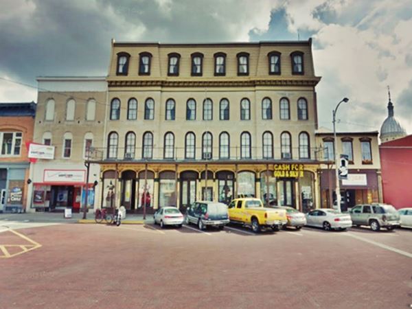
The highway went south along N Broad St. and reached the town's main square, where it crossed IL-108. The streets around the main public square are still paved with red bricks:
Loomis House and brick paved street at Carlinville's main square
Route 66 left the square with a west-to-east course along E Main St., and turned south along S. Center St. Here there are some realignments and missing segments. This is a map with directions across Carlinville showing the driveable road.
>> red line in custom map shows the Carlinsville segment, it also has the gaps marked.
Missing segment between E 1st St. and Jacobs Rd.
The higway ran further west, crossed the current alignment and then ran east of it, crossed Briar Creek and passed current Jacobs Rd before merging with the current alignment.
The modern alignment runs to the left of the old road shown in the photo below:
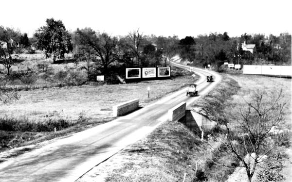
This alignment survived until recently, it can be seen in this aerial photo from 1956. Notice that Jacobs Rd. did not exist at that time.
See the pin marker next to the red line in our custom map.
1920s Original Road Surface (Carlinville Cemetery)
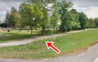
Continue south along old 66 - modern IL-4 and when you reach Country Club Ln. Carlinville Cemetery begins, to your left, on the eastsern side of the highway. The original highway roadbed curved to the east and ran along the edge of the cemetery. You can still see the narrow roadbed of this original road (pictured below).
See this 1956 aerial photo showing the highway running along the now dead-end in the local cemetery. The southern part of this segment is shown in this satellite view, and with a marker in our custom map beside the red line.
Macoupin Creek segment
After the cemetery, the later alignment runs with a NW-SE course, but the original highway curved east heading towards the now gone Macoupin Creek bridge (only the abutments remain), then it curved south and it meets the current IL-4 alignment (pictured). See marker by the red line in our custom map and also this aerial photo (1956).
Into Gillespie
Drive towards the next town along the highway: Gillespie. Head south from the Macoupin Creek segment, the highway curves to take a north-south alignment and at the curve, to the east there is another abandoned segment. See it in this 1956 aerial view.It was widened to its current position in the 1960s.
>> violet line in custom map shows the gap.
Deerfield Drive Segment
As you approach Deerfield Dr. there is an "original '66 section" along Deerfield Drive that curves around the modern (1932 alignment) to the west and then to the east at Honey Creek. This is a Map with directions from the Macoupin Creek segment to here.
Deerfield Route 66 segment in Carlinville, Illinois (modern IL-4 is on the left)
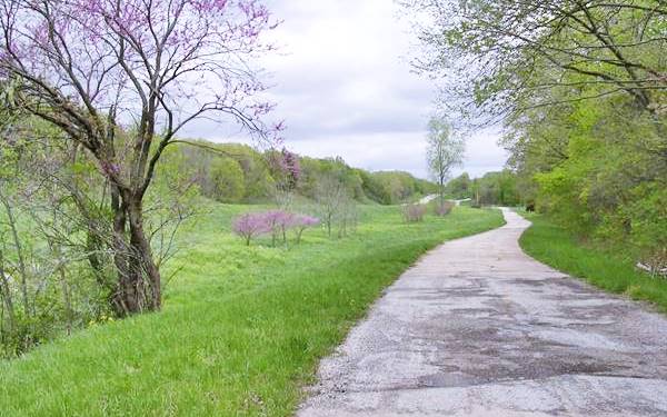
This section can also be seen in the 1956 aerial photo (scroll down) so the new highway was built after that date and before 1958 (the new IL-4 appears in a USGS map published in 1958). We put a marker by the purple line in our custom map to mark the spot.
>> violet line and marker in custom map shows the alignment here
Below is a USGS map showing the course of the highway here, crossing Honey Creek:

USGS map Deerfield Rd. alignment at Honey Creek

USGS map of Gillespie IL (1912)
Across Gillespie
Into Gillespie: State Highway 4 and the first Route 66 ran across the town along Elm St. and it met IL-16 as it turned to the SE along McCoupin St. On its southern end it did a dog leg along W Easton St and south along S Jersey St. You can see this in the map above where the red arrows mark Route 66 north and south of Gillespie. Then it ran south in a straight line towards Benld:
>> orange line in custom map shows US 66 to Benld.
Benld
The highway coming from Gillespie took two sharp turns when it reached Benld along "North Hardroad" and grazed the western side of the city. The later "South Hardroad" was built after 1930 and never carried Route 66 (map with directions - see the orange line in our custom map).
Then it ran straight southwards to Sawyerville.
Old concrete road surface
1.4 miles south of Benld, to your left is Fritz Road in the small community of Sawyerville. This short segment only 0.3 miles long is the original roadbed. It still has the original 1920s concrete paving. It was also known as the "hardroad" now named Fritz Rd. See this Map with directions and the marker in our custom map:
>> marker on blue line in custom map shows the Sawyerville road.
Old concrete road surface in Sawyerville, Illinois
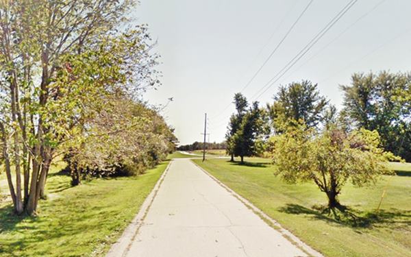
This alignment survived at least until 1956 because it appears in an aerial photo taken that year and the new soft-curve wasn't built at that time.
Notice the concrete "curbs" on both sides of the main concrete slab. Similar to the Modified Bates design used in the 1929 US 66 in Arcadia, OK.
Staunton Country Club missing road
As you can see in this 1973 aerial photo there is an original segment of highway on the southeastern side of the highway at Country Club lane - Gipsy Lane. The railroad crossing has been eliminated so it has dead ends on both streets. We marked it in our custom Route 66 map:
>> violet line in custom map shows the Staunton C.C gap.
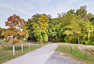
Don't miss the ghost paving on its northern tip next to the golf course (pictured)
Staunton, the final leg
This is the map with directions from Benld to the end of the 1926 US66 on the south side of Staunton.
>> blue line in custom map shows the Staunton alignment, 1926-30.
The original alignment continues through Staunton and on its southern side it ends at Williamson Rd.
Williamson Rd. Junction
In 1928 a straighter highway was being built between this point and Springfield, via Mt. Olive and Litchfield, to the east of Staunton. You can see it in the Illinois roadmap: the original 1926 alignment has been renamed "T 66" or "Temporary 66", with a new one built between Staunton and Litchfield along former IL-16, named "US 66".
This alignment was completed in 1930 and Temporary 66 was renamed IL-4.
South of this point, all the way to Worden Wye (a "Y" shaped Junction), the 1926 alignment was absorbed into the 1930 road and remained in use until 1942 when a new road was built linking Worden with Mt. Olive via Livingston.
>> red line in custom map shows the Staunton to Worden Y alignment.
We describe this final segment in detail in our Springfield to Hamel webpage.
The next section in our Road Trip itinerary, heading west is the alignment.
Continue your Route 66 Road trip:
More Route 66 Alignments
Previous Section
First segment of Route 66.
Next Sections
- Hamel to St. Louis
- Springfield to Hamel IL (1930-77 US66) south of Springfield.

Sponsored Content
>> Book your Hotel in Springfield

Credits
Banner image: Hackberry General Store, Hackberry, California by Perla Eichenblat
Jack DeVere Rittenhouse, (1946). A Guide Book to Highway 66.


