Route 66 in Normal IL
Index to this page
About Normal Illinois
Facts, trivia and information
Elevation: 869 ft (265 m). Population 52,980 (2025).
Time zone: Central (CST): UTC minus 6 hours. Summer (DST) CDT (UTC-5).
The city of Normal is located on Route 66 in McLean County, central Illinois. It is, along with Bloomington, a set of twin cities with a combined population exceeding 130,000 residents.
Normal, its History
The ancestors of the Illinois and Kickapoo Indians inhabited this region for over 11,000 years. During the historic period, the French arrived in the area in the 1600s, exploring it and trapping furs as a means of livelihood.
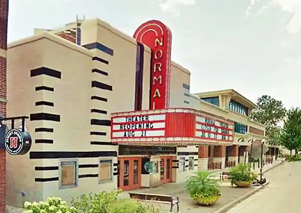
Normal Theater in Normal, Illinois
The Territory was ceded to the US government by Virginia in 1781 and organized into a state in 1818. It was then, in the early 1800s, that the first white settlers arrived. What is now Normal would have to wait until the creation of McLean County in 1830.
McLean County was named after John McLean, who had been a local pioneer lawyer, a territorial judge, the first Representative in Congress from Illinois (1818), and the United States Senator for Illinois(1824-1825).
Bloomington, to the south of Normal, was formally created the following year.
Joseph Parkinson platted the town of North Bloomington in 1854 at a strategic point where two railroads intersected, the Chicago and Alton Railroad and
The Illinois Central Railroad. The place was known as "The Junction". Jesse Fell expanded the original plat in 1857 and planted trees across the town.
Governor William Bissell signed a bill in 1857 that created a "normal school" in Illinois. Bloomington and Peoria competed for the school, which would be located in the place that provided the most convenient conditions. Bloomington secured a sound financial backing, and future President Abraham Lincoln gave a hand in drawing up a bond to guarantee the funds; this ensured that the university was located in Bloomington.
Normal schools
The "École Normale" or "Normal school" was a college system conceived in France in 1794 during the French Revolution to prepare professors and teachers. Reformed by Napoleon and reorganized in the 1840s, it was adopted in many countries around the world to provide a steady flow of trained teachers to educate their illiterate populace.
Bloomington's normal school was built in the district of North Bloomington. Work was completed quickly, and the university's main building was finished in 1861. However, there were only 20 houses in Normal by 1862.
The town was renamed as "Normal in 1865, and it was incorporated in 1867.
The Name: Normal
Named after the Illinois State Normal University, now known as the Illinois State University
When Route 66 was created in 1926, it was aligned through Normal. Later, in 1941, a four-lane "Bypass" was built around the eastern edge of Normal, which remained as US 66 until its delisting

Hotels and Motels in Normal
Find your accommodation in Normal; there are many options.
>> Book your hotel in Normal
More Accommodation near Normal on Route 66
Below you will find a list of some of the towns along Route 66 east and west of this town; click on any of the links to find your accommodation in these towns (shown from east to west):
Along Route 66 in IL
- Hotels in Illinois
- Route 66 Starting point ▸ Chicago
- Lockport
- Willowbrook
- Bolingbrook
- Plainfield
- Romeoville
- Joliet
- Wilmington
- Dwight
- Pontiac
- Chenoa
- Normal
- Bloomington
- Atlanta
- Lincoln
- Springfield
- Raymond
- Litchfield
- Staunton
- Williamson
- Hamel
- Edwardsville
- Collinsville
- Troy
- Glen Carbon
- Pontoon Beach
- Granite City
- East St. Louis
West in Missouri
- Hotels in Missouri
- Florissant MO
- Bridgeton MO
- St. Louis MO
- Kirkwood MO
>> See the RV campground in Normal and neighboring Bloomington
The Weather in Normal
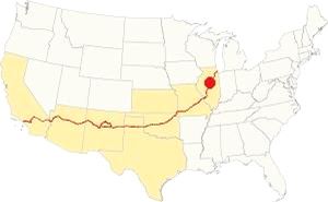
Location of Normal on U.S. Hwy. 66
The climate in Normal is a "Humid Continental" one, so it has very humid and hot summers and cold winters.
Its average temperatures are the following: during summer (Jul) the high is 85°F (29.7°C) while the low is 63°F (17.2°C). During winter (Jan) the avg. lows are a freezing 17°F (-8.3 deg;C) while the high is a chilly 30°F (-1 °C). Rainfall is around 38 in. (965 mm) per year, and the average number of sunny days is 194 per year.
Snowfall is 26 inches (66 cm) each year and falls from Nov to the first days of Apr.
Tornado risk
McLean County, where Normal is located, gets hit by some 7 tornadoes annually. Tornado Risk: read more about Tornado Risk on US 66.
Map of Route 66 through Normal, Illinois
>> Custom map with the alignments of US66 in Normal.
The original dirt surfaced stagecoach route to Springfield through Normal was upgraded and improved in 1915, becoming the Pontiac Trail. It was completely paved by 1923 from Chicago to St. Louis, MO, and became State Highway 4. In 1926, Route 66 was aligned along it.
Alignments
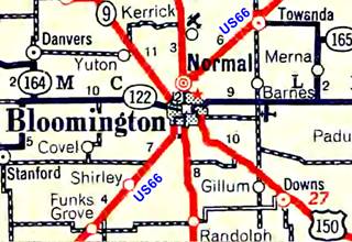
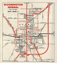
1936 IL DOT map of Normal and Bloomington, IL. Source
Click thumbnail map to enlarge
1926 to 1940 Route 66
The Mother Road was created in 1926, and it entered Normal from the northeast, from Towanda along E Pine Street, the highway crossed a residential district via Pine, Linden, and Willow Streets and then turned sharply to the left and headed south, bypassing Normal's Commercial district along its western flank by heading along N Main St. and Kingsley. Ahead, after crossing Division St., it entered neighboring Bloomington along Center Street. See the yellow line in our custom map.
1941 - 1977 "Beltline"
The town was bypassed when a four-lane highway was built to avoid congestion and accidents. This is marked with a white line in our custom map. The old alignment became "City 66."
Click on the maps below to enlarge them.
Visit our pages with old maps and plenty of information about US 66's alignments in this area:
The Route 66 alignments near Normal
- Springfield to Staunton IL (1926-30 US66) south from Springfield (next)
- Springfield to Hamel (after 1930) south from Springfield (next)
- Pontiac to Springfield (Normal's)
- Chicago to Pontiac (previous)

Route 66 Sights and Attractions in Normal, Il
Normal and Route 66 in 1946
Jack DeVere Rittenhouse mentions Normal in his "A Guide Book to Highway 66," which he published in 1946. He says that Normal and neighboring Bloomington are "virtually one community... city limits adjoining along one side," he adds that Normal was the location of the "Illinois State Normal University" and also that the town had "stores; hotels; Broadway Garage." However, he drove around it using the "beltway" alignment, avoiding City 66 with its congestion.
Your Road Trip attractions in Normal
Begin your tour on the northeast side of Normal coming from Towanda driving Historic Route 66, that shortly after passing beneath the Beltline 66 (along Veteran's Parkway) has a gap in its alignment: you will have to take Shelbourne Dr. westwards and then turn left (south) along Henry St. to bypass this cutoff.
Cutoff On Shelbourne Drive
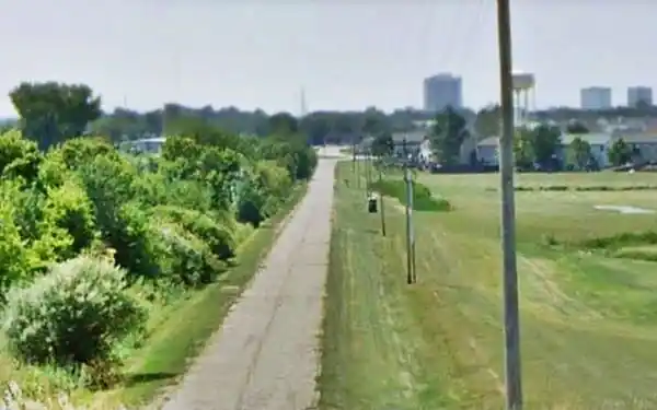
The original alignment from Towanda into Normal ran parallel to the railroad, but the segment north of N Towanda Avenue has been removed after the curve on Shelbourne Ave. The western section remains after N Towanda Ave, extending along the Frontage Rd. and ending in a dead end at the viaduct of N Towanda Ave. Below is a view from the viaduct looking west towards Normal:
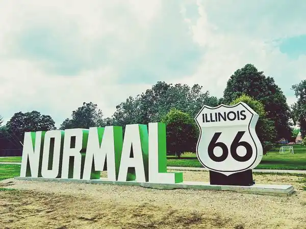
Route 66 Shield and Normal Sign
Continue westwards, and when you reach Pine Street and the tracks, to your left is the old alignment (Frontage Rd.) pictured above. Turn right towards Normal along E. Pine St., passing by the water tank. Ahead, to your right, on the NW corner where the highway reaches One Normal Plaza, is the 12-foot-tall Route 66 shield and the 8-foot-tall letters spelling the word "Normal". The sign is 43 ft. long. This is part of the 2026 Centennial celebration in Normal (learn more about the Route 66 Centennial (1926-2026)). See this map showing where it is.
Manning's Tourist Village site (gone)
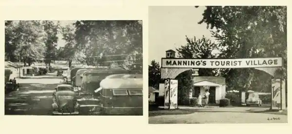
This spot was at one time a "tourist camp" called Diamond Camp catering to those who drove along Route 66 and also visitors to the state orphanage that was nearby. It changed name to Manninig's Tourist Village at 601 E Pine St. offering "Private showers, spacious grounds, shade. Exclusive but not Expensive." It finally closed in 1960. Tom Manning also woned a store at 507 Pine St.
Ann's Cafe
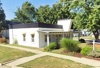
At the western tip of the park, on the SW corner of Pine and Beech St. is another Route 66 site, Ann's Cafe. The building with its eyecatching facade with an angled protrusion was a small café catering to those who stayed at the neighboring tourist camps.
Bill's Cabins (gone)
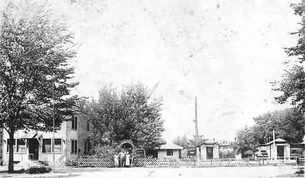
Head west, on Walnut St. and Pine to your right, on the NW corner is the site of Bill's Cabins on 306 Pine. Owned by William and Ana Snedaker, it had four cabins on the back of the property and a cafe on the corner, the latter is still standing (street view).
Historic Sprague’s Super Service
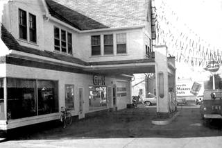
Sprague's Super Service 1970s. Source. Click image to enlarge
Listed in the National Register of Historic Places -Local Landmark - Route 66 Association of Illinois Hall of Fame
Opposite the cabins, on the SE corner, to your left at 305 East Pine St. is the Historic Sprague’s Super Service.
William W. Sprague built his "Sprague Super Service Station" in 1931 in a Tudor-Revival style brick building. The two-story structure looked like a manor house in England.
The upper floor was the home of the owner, and it had a separate room for the gas station employee. The ground floor housed the café, garage, and a service station that sold City Service gas
In 1940, the Route 66 bypass with four lanes opened east of Normal and Bloomington, so traffic along Pine St. dwindled. The station was modified in 1948 and 1967. In 1976, it closed, and its pumps were removed in 1979.
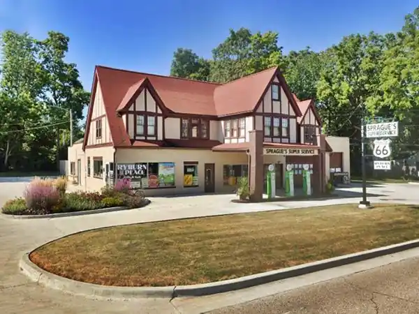
An information center and gift shop opened in Summer 2017; it is now owned by the Town of Normal. Don't miss the signs next to the building.
Just ahead, on the following corner is Another Oldie gas station:
Snedaker Gas Station
On the following street, to your right, NW corner of E. Pine St. and N. Oak St. This home was, at one time, a gas station. The steep gabled canopy over the area where the pumps once stood is a remnant from its service station days. It was Snedaker's station.
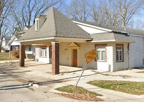
All of these landmarks (Ann's Cafe, Sprague's Station, Snedaker Station and Bill's Cabins can be seen in this Sanborn map of 1953.
There were many gas stations along the alignment of Route 66 in Normal, all of them have been razed (at Willow and Main, at 207, 216, 702, 901, 1003, 1201, 1202, and 1218 S Main. All gone!)
Normal Theater
Local Landmark
Keep west one block and turn left (south) along N. Linden St., at E. Willow take a right (there is a sign just before the intersection marking the way). Ahead at N. Main Street, turn south (left) and drive through Normal.
At W College Ave. turn right to visit the Theater (see this Map with directions).
209 W North St, Normal, four blocks east of Main St. It opened in 1937 with an outstanding Art-Deco & Art Moderne facade (it is pictured above). The site could seat 620 viewers. It was designated a local landmark in 1991. And has been restored to its original appearance.
Broadway Garage

1955 ad, Broadway Garage. Source. Click image to enlarge
Mentioned by Rittenhouse in 1946, it was one block west of the theater at 208 Broadway. Now a hotel stands on the premises.
Muffler Man at Carl's Ice Cream
Modern Attraction. Along College Ave. west of Route 66 at 1700 W College Ave (map with directions), is this local ice cream and burger place with Big Boy Carl, a 14-foot tall muffler man with a burger in one hand and an ice cream cone in the other, red shirt with Carl's written on its pocket, and wearing a white garrison cap. He is one of many Muffler Men on Route 66, in this case, a modern one!
> > Learn more about the Muffler Men on Route 66
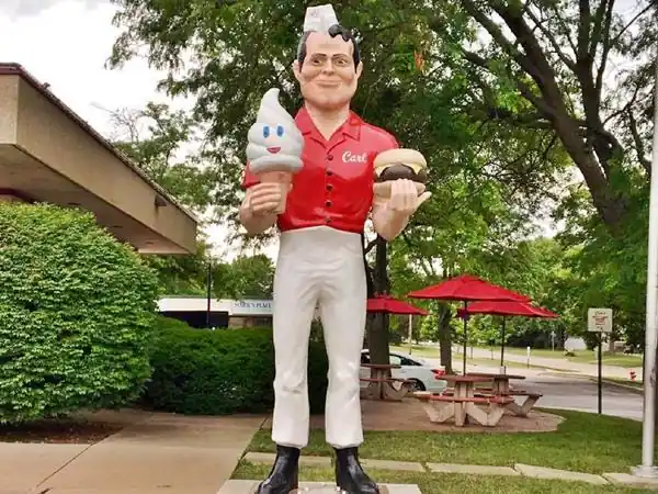
Return to Main St. and head south. Ahead, Main St becomes northbound, so you will take Kingsley St, which is southbound. After crossing Sugar Creek, turn left, and on the next corner, to your right, on the NW corner of S. Main and W Virginia Ave. is another Route 66 Classic Landmark:
First Steak ’n Shake
At 1219 S. Main Street, Normal. What is now Monical's Pizza was at one time the first "Steak 'n Shake", opened in 1934 by Gus Belt. The original building has survived!
Gus owned a Shell service station and added a restaurant to it, where, with his wife Edith, he sold burgers and shakes. He served his "Steakburger," a hamburger made from choice cuts of meat, here for the first time.
His business grew and became what is now Steak 'n Shake, a restaurant chain with over 500 locations in 27 states. Gus died in 1954, and his wife Edith ran the company until 1969.
Original building of the First Steak ’n Shake in Normal, Illinois
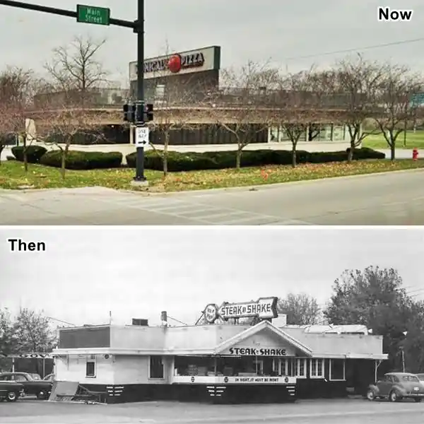
Sights along Bypass 66
No classic sights survive on the Beltline or Bypass 66 except for a highly remodelled building that was once part of The Prairie Travler (sic) Motel. This place opened in the 1950s and eventually had several buildings, a restaurant, and gas station on the highway. It was located on the SE corner of E Vernon Ave and what is now Veterans Pkwy.
You can see what it looked like in this aerial photo from 1966, the L-shaped building in the rear is now an apartment building, and this is its street view. See it also in this aerial view from 1968.
Continue your Route 66 Road Trip
This is where your drive through Normal ends, head south into Bloomington.

Sponsored Content
>> Book your Hotel in Normal

Credits
Banner image: Hackberry General Store, Hackberry, Arizona by Perla Eichenblat
Jack DeVere Rittenhouse, (1946). A Guide Book to Highway 66.

