Route 66 in Lexington IL
Index to this page
- About Lexington
- Weather
- Lexington's Hotels
- Map of US 66 through Lexington
- What to see and do on US66 in Lexington
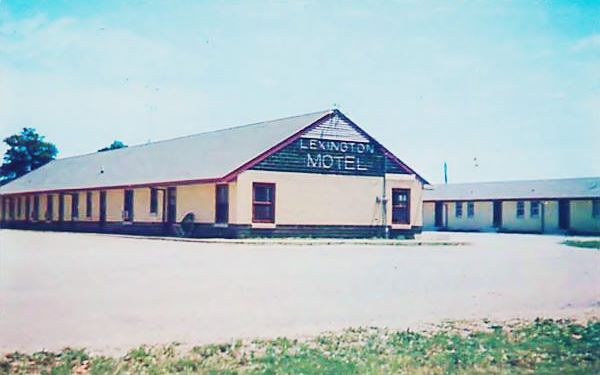
1950 Lexington Motel vintage postcard, in Lexington, Illinois
Lexington; Facts, Information and trivia
Elevation: 760 ft (230 m). Population 2,086 (2024).
Time zone: Central (CST): UTC minus 6 hours. Summer (DST) CDT (UTC-5).
Lexington is a town located on Route 66 in McLean County, Illinois.
The History of Lexington
The region around Lexington in the plains of Central Illinois has been inhabited for more than ten thousand years. These hunter-gatherers became the historic Kickapoo Indians encountered by the first French trappers and explorers that reached the area in the 1600s.
This area became a U.S. territory and then incorporated into the US as the state of Illinois in 1818.
The first settlers in Lexington were John and Margaret Patton in 1829 and they had eleven children. John built the first grain mill in the region. His cabin has been restored and is now located in the Lexington pool park and pavilion.
McLean County was created in 1830 and named for a local pioneer lawyer, John McLean who had served as territorial judge, the first Representative in Congress from Illinois, and the US Senator for Illinois.
The town was platted in 1836 by Asahel Gridley and James Brown during the mid-1830s town founding boom. As it predated the railroad (which reached the area in 1854) it has north-south and east-west aligned streets with a central square, and was located in the spot where the woods met the prairies.
The Name: Lexington
One of the town's founders, Brown was born in Lexington, Kentucky, and his hometown was named in honor of the first great battle of the Revolutionary War, the battle of Lexington, Massachusetts on April 19, 1775.
The Massachussetts town may have been named after the English peer Lord Lexington, or after the town of of Lexington (nowadays spelled Laxton) in Nottinghamshire, UK, whose name recorded as "Laxintone" in 1086 AD may derive from the Anglo-Saxon word "Leaxingtun" which means "farmstead of the people of a man called Leaxa."
In the 1850s, Jacob Spawr built his home there, and Abraham Lincoln lodged there frequently. The Chicago and Alton Railroad reached the town in 1854 bringing prosperity.
President Teddy Roosevelt visited Lexington in 1902, giving a speech at the train depot. The "Pontiac Trail" highway from Chicago to St. Louis passed through the town and was a more or less decent road for cars in the early 1910s. It was paved in the early 1920s as Illinois State Highway 4. This would be the roadway along which Route 66 would be aligned when it was created in 1926.

Lexington: Hotels and Motels
Accommodation close to Lexington.
> > Book your hotel nearby in Normal
More Accommodation near Lexington on Route 66
Below you will find a list of some of the towns along Route 66 east and west of this town; click on any of the links to find your accommodation in these towns (shown from east to west):
Along Route 66 in IL
- Hotels in Illinois
- Route 66 Starting point ▸ Chicago
- Lockport
- Willowbrook
- Bolingbrook
- Plainfield
- Romeoville
- Joliet
- Wilmington
- Dwight
- Pontiac
- Chenoa
- Normal
- Bloomington
- Atlanta
- Lincoln
- Springfield
- Raymond
- Litchfield
- Staunton
- Williamson
- Hamel
- Edwardsville
- Collinsville
- Troy
- Glen Carbon
- Pontoon Beach
- Granite City
- East St. Louis
West in Missouri
- Hotels in Missouri
- Florissant MO
- Bridgeton MO
- St. Louis MO
- Kirkwood MO
>> See the RV campgrounds in Normal and neighboring Bloomington
The Weather in Lexington
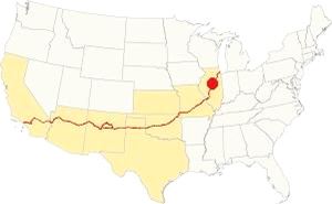
Location of Lexington on U.S. Hwy. 66
Lexington has a continental - humid climate with hot summers with little rainfall but high humidity. Its winters are cold.
The average temperatures for Lexington are: for winter (Jan) a high of 30°F (-1 °C) and a low which is quite cold: 17°F (-8.3 deg;C). The average for Summer (Jul) is 85°F (29.7°C) and the low is 63°F (17.2°C).
Yearly rainfall is 38 inch (965 mm), falling during 70 days on average every year. The town has 194 sunny days per year.
Expect snow between November and early April, it averages 26 inches (66 cm) yearly.
Tornado risk
Lexington is located in McLean county which experiences some 7 tornados per year.
Tornado Risk: read more about Tornado Risk on US 66.
Map of Route 66 through Lexington, Illinois
The original highway runs with a NE-SW course from Chenoa.
>> Custom map with the alignments of US66 in Lexington.
The first highway here was a dirt surfaced stagecoach route that linked the area with the state capital in Springfield. In 1915 it was upgraded and improved and became the Pontiac Trail. The trail was completely paved by 1923 linking Chicago with St. Louis MO and was designated as Illinois State Highway 4. In 1926 Route 66 was aligned along it.
Original Route Alignment
The image map shows the first alignment across the town, it had a sharp curve on Wall St. and Grove that was later cut by the four lane alignment and softened into the current wider curve into Grove St.
1940s - 1977 Route 66 in Lexington
The former southbound lanes of the 1950s 4-lane US 66 are now buried beneath I-55s northbound lanes, the blue line in our map shows the alignment all the way to "Memory Lane" where the original 1926-40s highway runs straight while the 1940s-77 bypass curves around the town .
The bypass was built because the old two lane road became damaged with use and the heavy traffic during WWII and required urgent improvement so a completely new four-lane alignment was built around the town; see the orange line in our custom map.
The 1926 to 1977 Route 66 continues with its SW course towards Towanda, with the former Southbound lanes of the 4-lane US 66 built after 1945 visible until I-55 approaches the road. Then they are overlaid by the freeway's Northbound lanes almost all the way to Towanda.
Route 66 is a Historic highway and has also been designated as a National Scenic Byway and an All-American Road in the state of Illinois.
Visit our pages with old maps and plenty of information about US 66's alignments in this area:
The Route 66 alignments near Lexington
- Springfield to Staunton IL (1926-30 US66) south from Springfield (next)
- Springfield to Hamel (after 1930) south from Springfield (next)
- Pontiac to Springfield (Lexington's)
- Chicago to Pontiac (previous)

Sights and Route 66 Landmarks in Lexington
Lexington's sights
US 66 historic context
In 1946 Jack DeVere Rittenhouse drove from Chicago to Los Angeles along Route 66 and published his classic "A Guide Book to Highway 66". He mentions the town of Lexington as follows: "small business district with gas stations, etc., garage but no hotel." He adds "The new freeway by skirting these smaller towns is affecting the portion of their income formerly received from tourists," this freeway wasn't I-55 but the four-lane divided highway that Route 66 became after the early 1940s.
Your Route 66 road trip across Lexington
We will drive from east to west, coming from Chenoa; on the north side of town is the first landmark.
Route 66 Memory Lane
Route 66 Attraction
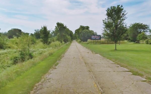
To your left, at Parade Rd. and Historic Route 66. Here the original roadway heads straight into town, while the 1940s-77 highway curves to the west (right). This stretch of road roughly one-mile long is the original 1926 roadbed that was used until the four-lane divided higway was built just west of it, to skirt Lexington. The highway has been restored and has some vintage billboards.
Meramec Caverns Barn (gone)
At its southern tip, the highway curves right, away from the tracks and enters the urbanized area of Lexington, becoming W Wall St. To your right, a few hundred yards to the north along the continuation of N Benson St. is a property on which stood one of the Meramec Cavern barns; they had painted roofs or walls facing Route 66 to promote the famous Meramec Caverns in Stanton Missouri. See this map marking the spot where the barn stood. There is a barn that is still standing nearby in Cayuga, and many more along US 66, in Hamel IL, Conway MO, Phillipsburg MO and Chandler OK.
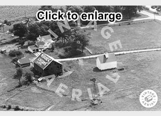
Meramec Caverns barn, 1966, Lexington. Source. Click image to enlarge
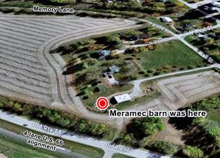
Meramec Caverns barn site, Lexington. Satellite view. Click image to enlarge
Many Gas stations (now gone)
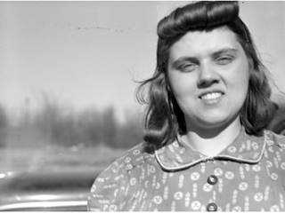
Clotis Lamkin, 1942, Lexington. Source. Click image to enlarge
This peaceful neighborhood at one time was bustling with traffic, and there were at least nine gas stations between the southern tip of Memory Lane and the south end of S Grove Street during Route 66's heyday, before it moved in 1948 to its four-lane alignment
The image shows Clotis Lamkin, gas station proprietor, and was taken on Jan 13, 1942 captioned "Lexington gas station operator interviewed regarding falling sales, 1942", and was part of an article titled "Gas station men on Route 66" published in Pantagraph as an interview feature about the impact of WWII on sales due to the drop in traffic along Route 66 by 25 to 30%.
Some of these filling stations according to the local newspaper, were: Garrett Service Station (1926) (Shell?), Lewis C Hill Service Station (1938), White Rose Service Station, operated by Larkin Pool (1940), Jenkins' (1938-42), Harry Tracy's (1943), and the Cities Service that is the only surviving gas station.
Anderson's Corner Cities Service station
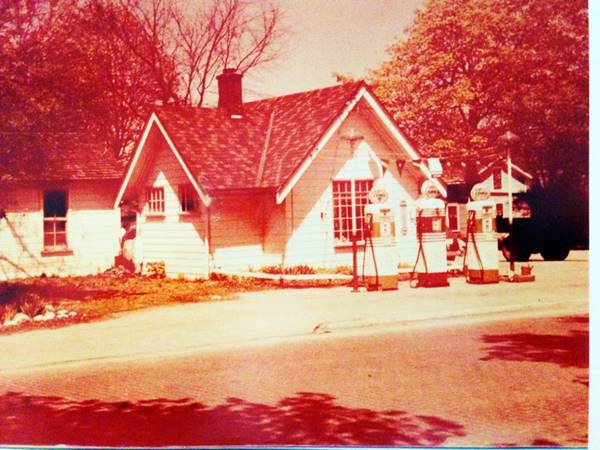
Wall St then curves south at Grove St., the original curve was sharper than the current one, but was sheared off and softened when the four-lane alignment was built. Head south, and after 3 blocks you reach West Main Street, on its NE corner with N Grover St. to your left is a typical ice-box shape of a 1940s gas station with the two door garage clearly visible and the office too.
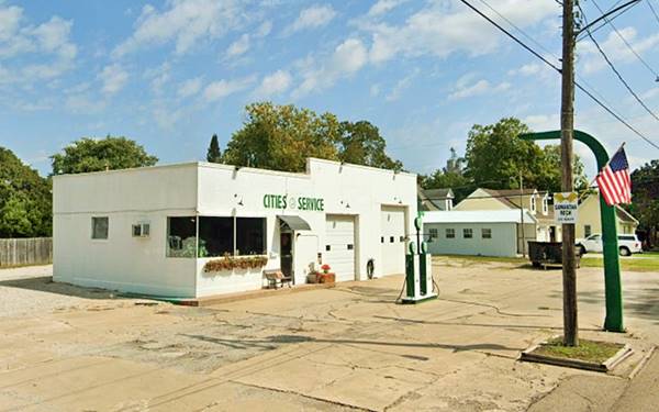
It started out in the 1930s, and was owned by Daniel Stamm from c.1930 to 1947, at that time it had a woodframe, gable roof cottage design with its pumps facing "Old" Route 66 as you can see in the image below (looks east from N Grove St., this is the current street view at that same spot).
The building was replaced by an icebox shaped one with a glazed corner office, one service bay and its three pumps along Main St. in the 1940s pictured below:
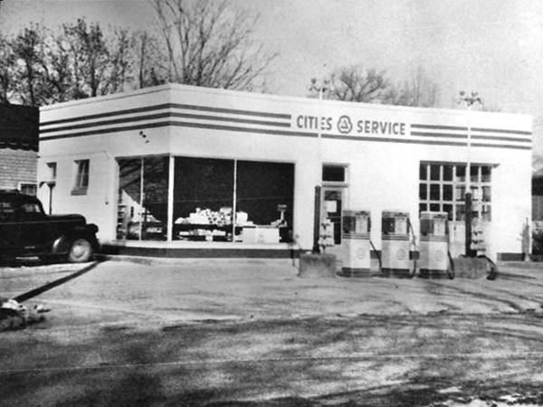
By 1950 it was ran by Virgil Hibbs as gas station and a grocery, followed by Herman Hudson. It was acquired by Albert Anderson in 1956 in a closeout sale. In 1966 it changed brands to Gulf and had several owners (Sims, Roger Kiersey, Hodges and Fred) until 1972. In the meantime it added a second service bay. By 1983 it was a Union 76 (aerial photograph). By the mid 2010s it was Anderson's Corner, a repair shop, now it has been once again decorated as a Cities Service station as you can see in the following image with its current appearance.
Farr Texaco station site
Across Main St. to your right, halfway down the block at 104 S Grover is the site of a former Texaco station. It belonged to John Farr, and had a design Texaco used from 1920 to 1930: brick exterior finish, a canopy with broad eves and brackets held up by large box columns with vertical elements that extend beyond the roofline, single-door entrance with double-hung windows. The original Texaco is pictured below. Then in 1949, it was featured in a newspaper article titled "married IWU art students, Mr. and Mrs. John Lueschen convert gas station into home" (October 20, 1949). As you can see in the photograpg they enclosed the canopy area; the roof still sports the protruding box-shaped elements. The house on the right side of the image is still there on the SW corner of S Grove and W Main streets. See this street view at that same spot.
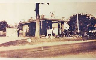
Farr Texaco US 66 c.1930, Lexington IL. Source. Click image to enlarge
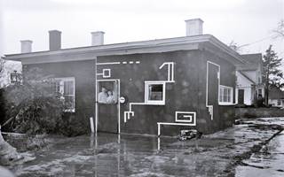
Farr Texaco as Lueschen's home in 1949. Source. Click image to enlarge
There are no other sites along the old alignment of Route 66, other than the Oasis Drive In that opened in 1960 at the junction of the four lane '66 with the original alignment. We describe it further down.
Return to Main Street and turn left, heading west to the four-lane Route 66
that is just one block away.
Site of Blair's Skelly and Mesa Cafe (Uncle Vaits Pizza)
The site to your right, at 905 W. Main St. has a long hsitory. Nowadays it is a restaurant, Uncle Vaits Pizza, but it was originally a gas station with an adjoining cafe.
Blair's Skelly Service station
Woody Blair opened the Skelly filling station here and was its owner in 1951 when the picture below was taken. Notice its flat canopy over the three pumps with its shining aluminum siding (the canopy has survived!). Mesa Cafe is attached to the left side of the building.
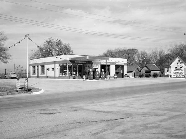
The station was ran by Ed Wissmiller in the 1950s and Andy Anderson owned it in the 1970s. It can be seen in this aerial photograph from 1966. The opening of the freeway led to its demise in the late 1970s.
Mesa Cafe
On the north side of the Skelly and attached to it, its postcard (below) promoted it as follows: "On Highway 66 - in Central Illinois McLean County. Where good food is served with prompt service. Also carry-out service. Open 5:30 a.m. to 12:00 p.m daily." It was owned by Eileen Buzzard. Its 1961 ad read: "MESA CAFE "Second Best Place to Eat." When I-55 opened, the cafe closed.
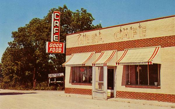
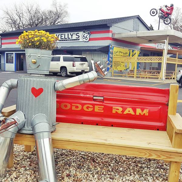
Jari Riisberg and her husband bought the property and made their home in the old Skelly building and reopened a restaurant in 1982, and they named it "The Filling Station." It closed in 2011. Kelly Tobin bought it in 2017 opening his restaurant that encompassed both the Skelly gas station and the former Mesa Cafe. Tobin kept the original buildings and freed the area under the old canopy for an outdoor dining area. He added a motorcycle doing a wheelie on the tip of a pole on top of the old canopy and renamed it Kelly's on 66.
In 2021 Tobin sold the property to Abdulvait "Uncle Vait" Jaoski who has opened his Uncle Vait Pizza restaurant kept the Route 66 decorations, with a motorcycle and the Route 66 shield. There is a nice bench for your Route 66 photograph capturing the whole scene (see below). Notice the original aluminum canopuy on the right side of the image
Route 66 Shield and Lexington Centennial Sign
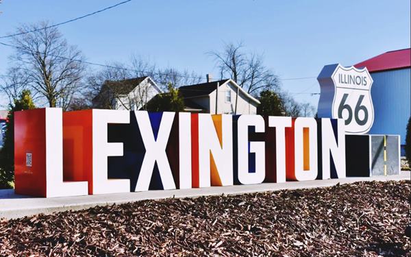
On the corner, to your left is the new monument and marker with a Route 66 shield and multicolored letters spelling the word "Lexington". It is part of the 2026 celebration of the Route 66 Centennial (1926-2026)

Across Main opposite the Skelly site, on its southern side (SE corner with Route 66) you will find several landmarks.
Gleason's Mobil site
Where Stinde Electric is now located (910 W Main St.) was Allen Gleason's Mobile station, now gone.
Originally Gleason's was located in downtown Lexington but he moved to this site to be on the new divided highway alignment. The image below shows the station (Main is on the left) seen from Route 66. The gable roof of neighboring Lexington Motel can be seen on the far right.
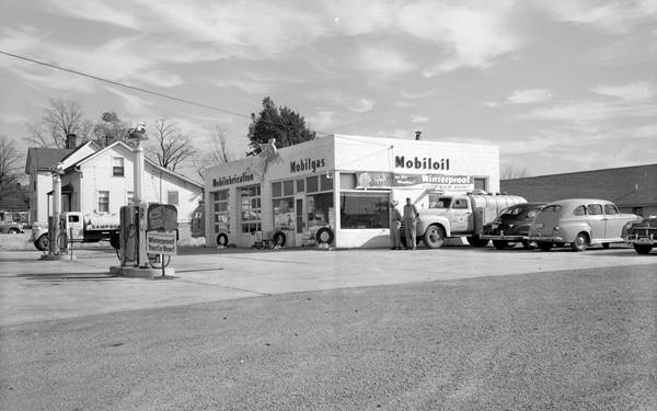
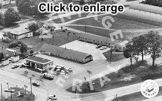
1966 view Gleason's Mobil and Lexington Motel. Source. Click image to enlarge
The aerial photograph taken in 1966 looks southwards, you can see Main St (lower left) and the Mobil station (center) followed by Lexington Motel's two linear gable roofed buildings and U.S 66 four lane highway (lower right).
Lexington Motel
On the south side of the Mobil station, accessible at 105 Morris St. Lexington
The Lexington Motel's postcard advertised it had "18 Good Clean Units All Morern Air Conditioned Televsion..." It opened in 1950 on the strategic junction of Main and Route 66, at that time it was owned by Carl Christianson.
From 1964 until it closed in 1978, Barbie Freed and her husband Doug managed the motel; she recalled that "several celebrates stayed here and one was Captain Kangaroo!" (a children's TV series aired from 1955 until 1984, the Captain was played by Bob Keeshan).
As with all businesses here, I-55 brought a drastic reduction in travelers along old U.S. 66 and the motel was converted into apartments.
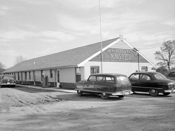
Same spot nowadays; fortunately for history, the building hasn't changed:
Former Lexington Motel vintage nowadays in Lexington, Illinois
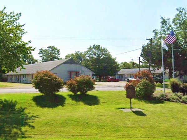
Historic Route 66 Marker
On Eastside park by the motel that separates Morris St. from Route 66 is a Marker. The brown marker can be seen in the image above, to the right. It was erected by the Illinois History Club of Lexington High School and the Illinois State Historical Society. It reads:
"In 1926, construction began on a 2,448-mile highway from Chicago to Santa Monica, California. Route 66 reflected the increased use of motorized vehicles. The road, which cut diagonally across Illinois, passed through Lexington. Sleek restaurants, service stations and motels were built specifically to accommodate travelers. The original two-lane, concrete highway - a section of which is located here - was replaced over a span of thirty years by the more modern interstate highway system. In Illinois, Interstate-55 closely parallels old Route 66."
Lexington Neon Arrow Sign
Route 66 Neon Sign
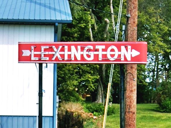
Across the four lane highway, on its NW corner with W Main St. is this classic sign that was erected in the late 1940s and it pointed along Main Street into the downtown district that was east of the bypass "freeway" built at that time. Its purpose was to attract travelers into the central business district of Lexington.
The Neon Arrow Sign has been restored and placed in its original position, an icon from the good old "neon era" on Route 66.
Lexington Neon Arrow Sign in Lexington, Illinois
Brodner Standard Station & Lexington Cafe (gone)
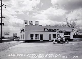
1951 Brodner Standard & Lexington Cafe. Source. Click image to enlarge
Across the street from the neon sign, at 1002 W Main on the SW corner was Leo Brodner's Standard Station. It was originally a woodframe building that burned down in 1959 and was rebuilt with blocks with an "icebox" station design. The modern Freedom Oil Gas station stands on the site. You can see it also in this aerial photo taken in 1966. Leo retired in 1987.
The Cafe began as George's Cafe, and by the late 1950s was operated by Myra "Ma" Giles; its 1961 ad read: "Home Cooked Meals Pies Open 6:00 A.M. to 12:00 P.M. Daily MYERS, INC."
Oasis Drive In
Drive south for 0.6 miles along the 1940s-77 Route 66 alignment map with directions to visit a classic sight. located at the junction of the original and the final alignments of the Mother Road in Lexington: Route 66 & S. Grove St.
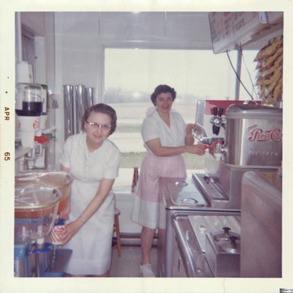
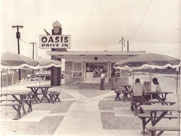
The Oasis Drive In was built by Elmo Winterland in 1960 and it was ran by Elmo and Arline Winterland. The image below shows Arline Winterland and Verneil Siron, inside Oasis, in April, 1965.
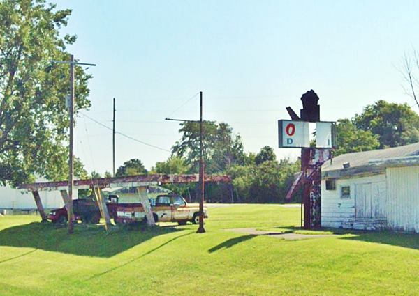
It was a classic in Lexington and remained in business from 1960 to 1976 when it closed. The original sign is still there, rusting away (compare the black and white photo with the current view below). Don't miss the very 60's Googie style car park canopy with a Space Age touch to it.
Current view of the vacant property:
Stuckey's (gone)
Oasis Drive In is the last stop in town, the next "sight" is on the 1926-77 highway as you drive towards Towanda, 3.3 miles west of Lexington at the overpass of E 2200 N Rd., the site of Stuckey's.
There were many Stuckey's along Route 66 offering gas, coffee, and pecan nuts. This one closed as it lay in the way of the westbound lanes of I-55. It closed on Good Friday, 1975. Nothing remains of it. You can see its location in this map marking the spot where it stood. Below is an aerial view from 1966 and a color postcard:
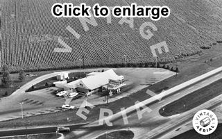
1966 view Lexington Stuckey's. Source. Click image to enlarge
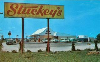
1950s postcard of Lexington Stuckey's. Source. Click image to enlarge
Continue your Route 66 Road Trip
This ends your drive through Lexington. Continue west into Towanda, the next town of your Route 66 Roadtrip.

Sponsored Content
>> Book your Hotel in Chicago

Credits
Banner image: Hackberry General Store, Hackberry, Arizona by Perla Eichenblat
Jack DeVere Rittenhouse, (1946). A Guide Book to Highway 66.


