Route 66 in Shirley IL
Index to this page
Shirley Illinois
Facts, trivia and information
Elevation: 764 ft (233 m). Population 62 (2023).
Time zone: Central (CST): UTC minus 6 hours. Summer (DST) CDT (UTC-5).
Shirley or Shirley is a tiny unincorporated community located next to Route 66 in McLean County, central Illinois.
History
In historic times, when the French explored the area in the early 1600s, the met the local native tribe, the Illini (Illinois).
The first settlers arrived Central Illinois during the early 1800s but the actual settlement of the prairies took place after the arrival of the railroad in the early 1850s. McLean county was created in the 1830s.
The St. Louis Chicago and Alton Railroad had reached this area around 1853 and a small siding was built here. Some lots were platted but nothing more happened until John M. Foster platted the town in 1866. He opened a store close to the station on the south side of the tracks and the town was built on the north side.
The name: Shirley
The town was named by Mrs. Croydon Weed for the heroine in a novel that she was reading, very probably Charlotte Brontë's novel Shirley (1849).
The name (originally a male name) comes from an Old English place name "scir" Shire or bright, clear and "leah": wood, clearing, meadow. It is also a common Hebrew name meaning "son unto me".
The town had a mill and by 1895 the church and a hotel. In 1926 Route 66 was aligned along the road that ran on the south side of the tracks by the town.

Hotels and Motels near Shirley
Accommodation close to Shirley along Route 66.
> > Book your hotel nearby in Bloomington
More Accommodation near Shirley on Route 66
Below you will find a list of some of the towns along Route 66 east and west of this town; click on any of the links to find your accommodation in these towns (shown from east to west):
Along Route 66 in IL
- Hotels in Illinois
- Route 66 Starting point ▸ Chicago
- Lockport
- Willowbrook
- Bolingbrook
- Plainfield
- Romeoville
- Joliet
- Wilmington
- Dwight
- Pontiac
- Chenoa
- Normal
- Bloomington
- Atlanta
- Lincoln
- Springfield
- Raymond
- Litchfield
- Staunton
- Williamson
- Hamel
- Edwardsville
- Collinsville
- Troy
- Glen Carbon
- Pontoon Beach
- Granite City
- East St. Louis
West in Missouri
- Hotels in Missouri
- Florissant MO
- Bridgeton MO
- St. Louis MO
- Kirkwood MO
>> See the RV campground in neighboring Bloomington
The Weather in Shirley
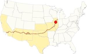
Location of Shirley on U.S. Hwy. 66
Shirley has a humid continental climate: hot, humid summers and cool to cold winters.
The average high for winter (Jan) is 34°F (1 °C); the average low for winter is 18°F (-7.8 deg;C).
The summer average high (Jul) is 85°F (29.7°C) and its low is 65°F (18.1°C).
Precipitation is lowest in January (1.93 in. - 49 mm) and peaks at 5.08 in July (129 mm).
Yearly rainfall is 36.7 inch ( 1008 mm). Snow falls from November through March and averages 22 inches (55 cm).
Tornado risk
Shirley is located in Mc Lean County, which is struck by around 7 tornados per year.
Tornado Risk: read more about Tornado Risk on US 66.
Map of Route 66 through Shirley in Illinois
After Bloomington the highway continues with a SW course into Shirley. During the late 1940s it was upgraded with the addition of a second set of northbound lanes. These were later removed when I-55 was built and they lie under the southboun lanes of the freeway. Only the former westbound lanes of US 66 have survived.
See the pink line in our custom map Map of Route 66 in Shirley, Illinois. USGS 1951
At Shirley the two northbound lanes are now beneath the "Constitution Trail" for joggers and bike fans.
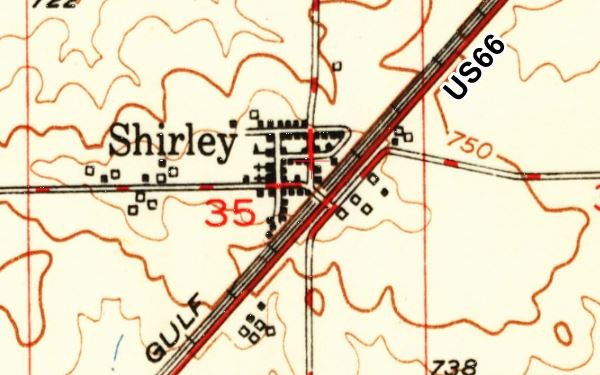
The Route 66 alignment in Shirley
Visit our pages with old maps and plenty of information about US 66's alignments in this area.
- Springfield to Staunton IL (1926-30 US66) south from Springfield (next)
- Springfield to Hamel (after 1930) south from Springfield (next)
- Pontiac to Springfield (Shirley's)
- Chicago to Pontiac (previous)

Attractions on Route 66 in Shirley
Landmarks Shirley
Historic Context: Shirley US 66 in 1946
Jack Rittenhouse mentions the town in his "A Guide Book to Highway 66" published in 1946: "Garage. No tourist facilities in this small community, with its grain elevators surrounded by smaller cribs to hold extra grain. A few homes and a few stores."
The community is still a tiny one and not much has changed since Rittenhouse drove by.
Shirley lies on the right side of Route 66 as you approach it from the east. The railroad tracks lie between the town and the highway. There is a bridge at Quinn St. crossing the tracks, which here lie beneath the level of the town in a cutting made in 1909.
Site of Shirley Depot
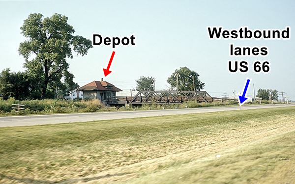
On the western side of Quinn St. bridge, you can see the concrete pier of the original bridge across the railroad. The new bridge was built on the eastern side of it, but the original railroad depot dating back to 1909 which stood in its path was removed (1970) and taken to neighboring Funk's Grove. There you can see the Old Shirley Depot.
Below is a "Then and Now" sequence of the old Depot, the older photo is from 1965, and taken from the now removed eastbound lanes of the four-lane US66.
Shirley, Illinois railway Depot and Route 66 ca.1965
Shirley, Illinois railway Depot and Route 66 nowadays (with new bridge)
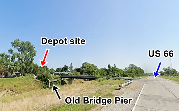
The large tall tree next to the depot in the 1965 picture, and the bridge in the current view is probably the same one.
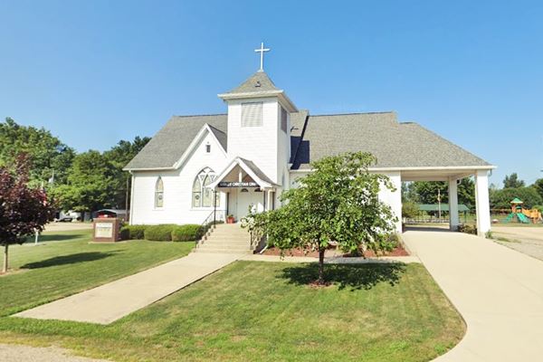
Shirley Christian Church
202 Meridian Stree. This is the old wooden building from the late 1800s.
Christian Church in Shirley, Illinois
Funk Prairie Home and the Funk Gem and Mineral Museum
10875 Prairie Home Lane, Shirley. Just 2.6 miles south of Shirley (map with directions).
It is located in the restored home of Lafayette Funk, built in 1864. He was a local cattle man and a politician. His home has many antiques and memorabilia from the mid to late 1800s.
The museum has a collection of petrified wood, rocks and fossils as well as Native artifacts.
Old section of US 66 Roadbed
At the junction of the access road to Shirley (Quinn St., IL-34) with Historic Route 66 is a stretch of old roadbed, but it isn't Route 66.
It is the old and now abandoned State Highway 41, which runs south until it stops at a dead end, cut off by I-55. It continues south of the freeway all the way to U.S. 136.
Route 66 was a four-lane highway here, but without overpasses. The two former northbound lanes are now buried beneath the "Constitution Trail" built for joggers and bike fans.
North of Shirley you can see a very small segment of these two lanes as shown in the image below. In the picture, the eastbound lanes are now under the grass both left and right of the concrete strip now used as part of a road that heads transversal to the US 66 alignment.
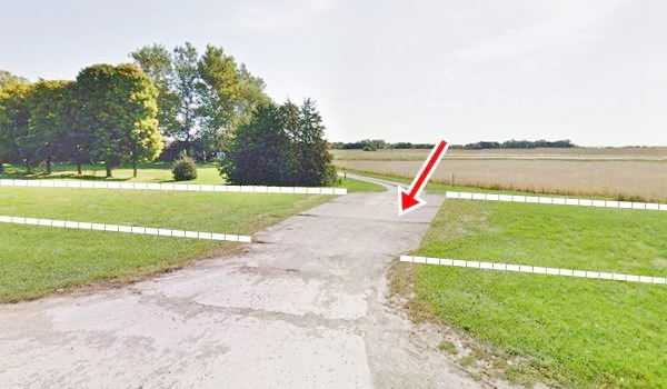
The dashed line marks the former alignment.
Continue your Route 66 Road Trip
This marks the end of this leg of your road trip in Shirley, head south to continue your journey and visit the next town: Funk's Grove.

Sponsored Content
>> Book your Hotel in Chicago

Credits
Banner image: Hackberry General Store, Hackberry, Arizona by Perla Eichenblat
Jack DeVere Rittenhouse, (1946). A Guide Book to Highway 66.

