Route 66 in Towanda IL
Index to this page
About Towanda, Illinois
Facts, trivia and information
Elevation: 776 ft (237 m). Population 429 (2024).
Time zone: Central (CST): UTC minus 6 hours. Summer (DST) CDT (UTC-5).
Towanda is a village in McLean County, Illinois. East of Normal, and located on the alignment of Route 66
History of Towanda
When the first Europeans explored this area in the early 1600s, they encountered Illinois and Kickapoo Indians. Later it became part of Virginia, who ceded it to the US government in 1781.
The Territory became the state of Illinois in 1818, and it was then that the first settlers established themselves on the prairies.
McLean County was created in 1830 and named for a local pioneer lawyer, John McLean who had served as territorial judge, the first Representative in Congress from Illinois (1818) and the United States Senator for Illinois (1824-1825).
In 1826 John Trimmer settled in Towanda, followed by Jesse Walden in 1828. There was a post office here since 1843, named Money Creek.
The completion of the Chicago, Alton & St. Louis Railroad in 1853 led to the platting of the town by Jesse Fell and Charles Holder on land owned by Peter Bedeau.
The Name: Towanda
Fell named it after his hometown, Towanda in Bradford County, Pennsylvania. The name comes from the Native American Delaware Nanticoke word "Awandae" which means "Burial place"
State Higway 4 was built through the town in the early 1900s; following the railroad and the old stagecoach trail. The highway was paved in the mid 1920s and shortly after, when Route 66 was created in 1926, it incorporated that highway into its alignment across Towanda.
Later a straighter two-lane highway would be built around the western side of Towanda, to straighten out the original US 66, enlarged to four lanes in 1954 and remained in use until the highway was delisted in Illinois

Towanda: Hotels and Motels
Accommodation close to Towanda.
> > Book your hotel nearby in Normal
More Accommodation near Towanda on Route 66
More hotels & motels nearby along the highway in neighboring towns and cities:
Below you will find a list of some of the towns along Route 66 east and west of this town; click on any of the links to find your accommodation in these towns (shown from east to west):
Along Route 66 in IL
- Hotels in Illinois
- Route 66 Starting point ▸ Chicago
- Lockport
- Willowbrook
- Bolingbrook
- Plainfield
- Romeoville
- Joliet
- Wilmington
- Dwight
- Pontiac
- Chenoa
- Normal
- Bloomington
- Atlanta
- Lincoln
- Springfield
- Raymond
- Litchfield
- Staunton
- Williamson
- Hamel
- Edwardsville
- Collinsville
- Troy
- Glen Carbon
- Pontoon Beach
- Granite City
- East St. Louis
West in Missouri
- Hotels in Missouri
- Florissant MO
- Bridgeton MO
- St. Louis MO
- Kirkwood MO
>> See the RV campgrounds in Normal and neighboring Bloomington
The Weather in Towanda
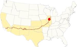
Location of Towanda on U.S. Hwy. 66
With its Humid Continental climate, summers in Towanda are very humid and hot and its winters are quite cold and with plenty of snow.
The average winter (Jan) temperatures are: high, 30°F (-1 °C); low, 17°F (-8.3 deg;C). The average summer (Jul) temperatures are: high, 85°F (29.7°C); low, 63°F (17.2°C).
There are 71 days of rain each year, and around 38 inches fall on average (965 mm). The sun shines on 194 days each year.
Snow may fall between November and early April, and 26 inches (66 cm) fall on average each year.
Tornado risk
McLean county, where Towanda is located is hit by around 7 tornados each year. Tornado Risk: read more about Tornado Risk on US 66.
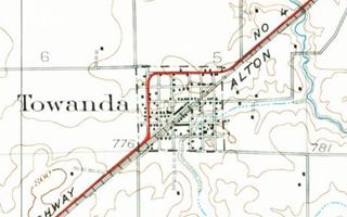
Map of Route 66 through Towanda, Illinois
>> Custom map with the alignments of US66 in Towanda.
The original dirt surfaced stagecoach route to Springfield through Towanda upgraded and improved in 1915 becoming the Pontiac Trail. It was completely paved by 1923 from Chicago to St. Louis MO, and became State Highway 4. In 1926 Route 66 was aligned along it.
Original Alignment
Originally U.S. 66 was a two-lane road marked with a red line in the image map and also with a red line in our custom map. The heavy traffic of wartime America led in the mid 1940s to the construction of a second road, around the town planned to become a four-lane highway, safer and straighter. This "bypass" highway was built around Towanda to eliminate the sharp curves and add a set of lanes to the highway, see the gray line in our custom map.
The original alignment had the infamous Dead Mans Curve a right angle turn on the west side of town. There were several of these curves on the original Route 66 that were built when highway construction was new and they made Route 66 dangerous (Bloody 66).
On the south side of Towanda there is a gap in the alignment, after the tip of S Quincy St.
In 1954 a second pair of lanes were added to it, upgrading Route 66 to a four-lane divided highway.
The original lanes were the southbound lanes and the new north bound lanes were opened in late 1954.
Current Historic Route 66 runs along those former northbound lanes. The other pair was abandoned when the freeway was completed in 1976.
Visit our pages with old maps and plenty of information about US 66's alignments in this area:
The Route 66 alignments near Towanda
- Springfield to Staunton IL (1926-30 US66) south from Springfield (next)
- Springfield to Hamel (after 1930) south from Springfield (next)
- Pontiac to Springfield (Towanda's)
- Chicago to Pontiac (previous)

Sights and Attractions in Towanda
Route 66 Landmarks Towanda
Towanda and Route 66 in 1946
Jack DeVere Rittenhouse published his "A Guide Book to Highway 66" in 1946 and mentions Towanda as follows:
Towanda... garage; stores... A small business disrict is off the highway Rittenhouse (1946)
We will drive this leg of your Route 66 road trip from the east, coming from Lexington.
Driving across Towanda
Asian Arts (gone)
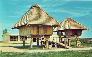
Asian Arts Store, Route 66 Towanda. Source. Click image to enlarge
Located 0.9 mi. west of the E2200 N Rd. overpass is the site of the Asian Arts store that opened on July 23, 1965 (pictured). You can see it in this aerial photograph taken in 1966 with its two Asian huts and the four-lane alignment beyond. The postcard shows the huts and the store; the card states "Asian Arts Route 66 Towanda, ILL... Importers of handcrafted gifts and objects of art... This house and granary were hand carved by Ifugao tribesmen in the Mountain Province of the Philippines."
The site was razed when I-55 was built in the late 1970s, and now lies beneath the westbound lanes (map showing where it stood).
Ahead the freeway moves away from Route 66 to curve around Towanda, and to your right you will see the abandoned set of lanes of the four-lane U.S. 66. The original lanes were the southbound lanes and the new north bound lanes were opened in late 1954. Current Historic Route 66 runs along those former northbound lanes. The other pair was abandoned when the freeway was completed in 1976.
The Towanda Route 66 Parkway
66 Roadside Attraction
These abandoned old lanes can be seen, to your right, from the point where the freeway curves away from the highway to circle Towanda, 2.5 mi. northeast of the town. Here is a parking area with a gazebo that marks the northern tip of the Route 66 Parkway. It is ideal for those who want to walk or cycle along it. There is another parking area on the southern end, in Towanda.
It can be walked or you can ride a bike along it, but no motor vehicles are allowed. It was built by volunteers from Towanda and students and teachers from the Normal Community High School on top of the former southbound lanes of Route 66.
It extends south, for 3.5 miles into Towanda. It has educational kiosks that interpret each of the eight states that Route 66 goes through, decorated with murals, maps, and also replicas of the Burma-Shave signs that at one time were displayed along Route 66 like the one in the image below, the full text reads:
"Don't pass cars - On curves or hills - If cops don't get you - Morticians will - Burma Shave."
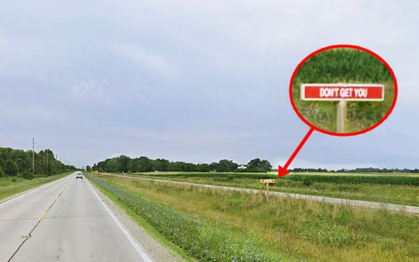
Burma Shave
Burma-Vita was a company based in Minesota. Starting in 1926 with the creation of the U.S. highway system they began to advertise their "Burma Shave" shaving cream using these red eye-catching signs. They spaced them some hudred feet apart, and each sign had a few words, that combined with the text on the other signs formed a rhyme.
There were dozens of funny phrases, see some examples below:
"If hugging on highways - is your sport - trade in your car - for a Davenport - Burma Shave" (Davenport is the name of a sofa ⁄ couch bed that could be slept on made by the now defunct A. H. Davenport Co. of Massachusetts.)
"Are your whiskers - When you wake - Tougher than - A two-bit steak? - Try - Burma-Shave"
"The bearded lady - Tried a jar - She's now - A famous - Movie star - Burma Shave."
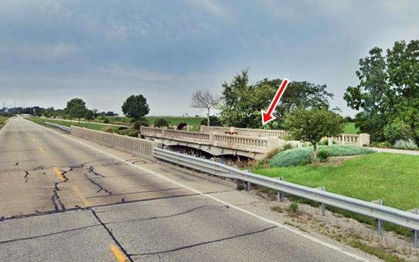
Money Creek Bridge
Ahead, at Money Creek is the original Route 66 bridge built in 1945 and is still open to pedestrians and cyclists using the "Parkway":
Money Creek Bridge in Towanda, Illinois
Continue towards Towanda and ahead, to your left at Lincoln Road and Route 66 is the fork where the original 1926 alignment used to enter town (by the railroad, to your left). It had a very winding course through town, turn left and follow it.
Kicks Bar & Grill
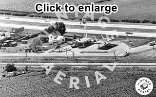
1971 aerial view Gulf Station, Route 66 Towanda. Source. Click image to enlarge
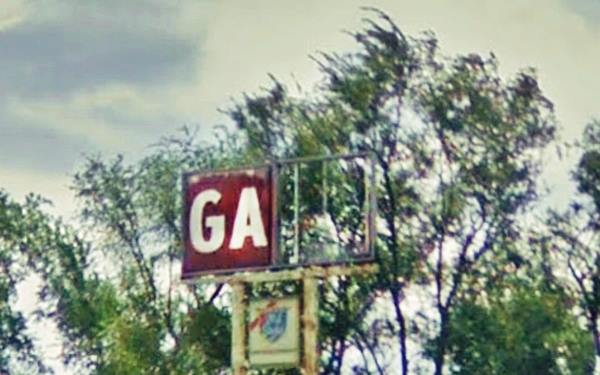
To your left, at the Y formed by the alignments of Route 66 (19578 N 1960 East Rd) is a former Gulf service station.
At one time it sported modernistic canopies over the pumps, wing-shaped and suspended from canted steel poles as you can see in the 1971 aerial photograph (click on it to see the large sized image). It looks west and shows the railroad in the foreground, the 1926 US 66 next to it, the Gulf station building that now serves as the U.S. 66 Kicks Bar & Grill, and beyond is the four-lane Route 66 (the current Parkway was still used by cars in those days).
Original 1926-40s Route 66
See this Map with directions.
As you drive south along the old alignment it becomes Jackson St. and curves away from the railroad taking an east to west direction to skirt around the downtown district. Just ahead the original alignment is now cut by the four lane Route 66, but it used to continue straight westwards.
Site of Eddie's Pure Oil Truck Stop
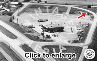
1971 aerial view Pure Truck Stop.
Red arrow is the Deadman's Curve.
Source. Click image to enlarge
After crossing the 4-Lane Route 66, to your left, at 204 N Jefferson is a gas station, formerly a Truck Stop. Over the years it has changed hands many times and been renamed, the original building is gone. The thumbnail image (click on it to enlarge it) shows the 4-lane 66 (left), the truck stop, and on the upper right side (red arrow), the Deadmans curve.
Delmar C. Haines (1904-1978) opened this gas station and truck stop here in 1952; he also had another in Gibson City Illinois. he named them Del-Co.
In 1956 it became Foster's Pure Cafe and Station Stop that provided service to 250 to 300 truckers a day. It had a 2 acre parking space and a 100-seat restaurant that offered "six plate lunches ranging from 95c to $1.20 in price."
Pure Oil Co.
Pure Oil Company was estabilshed in 1914. They acquired Hickock Oil in 1928 and used their Hi Speed brand. The first service station exclusively dedicated to trucks was a Hi Speed one in Imlay City MI, in 1935. The truck stops grew and by 1951 had reached 28 stops. Pure rebranded them and built a network of over 200 stops across the center and eastern US. Pure Oil was bought out by Union Oil Company of California in 1965 and replaced their brand with Union 76 after 1968. By 1970 there were no more Pure gas stations.
The magazine ad published in 1958 reads: "Sure sign of good food ... a PURE TruckStop - Foster's PURE TruckStop (on Route 66 at Towanda, Ill.) was recently given American Restaurant magazine's Editorial Feature Award for "outstanding service to the dining public, the community it serves, and the food industry as a whole." ... The truck driver is king at our more than 200 highway hotels stretching from the Dakotas to Florida." They were operated by independent franchisees.
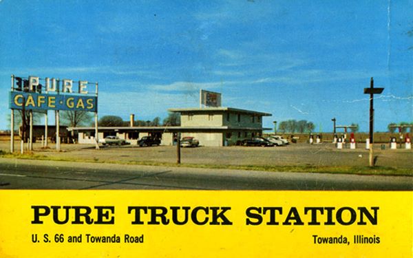
In 1963 Edward Baize bought it and it became "Eddies Truck Stop". It closed for good in 1976 when the freeway opened. The building was torn down the property sold. A BP station stands on the property.
Towanda Dead Man’s Curve
Classic Route 66 spot
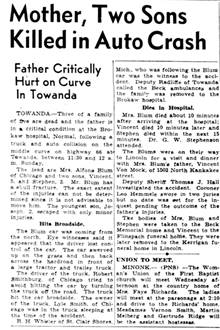
1940 Newspaper article about deadly accident at Deadman’s Curve. Source. Click image to enlarge
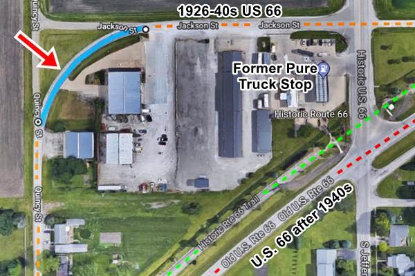
Turn left after passing the truck top and just ahead, at Jackson and Quincy St. is the deadly curve.
It is a 90° curve towards that changes the alignment of Route 66 from east-west to north-south. The curve took drivers by surprise, a narrow highway which was ony 18 feet wide and high speed car led to many accidents here. Like the one that killed three members of the Blum family in Sept. 2, 1940 at the "Middle Curve" (there were three curves in towanda, the North one, the Middle one, and the South one. See the red line and marker in our custom map.
It was built on the first paved highway in Towanda, Illinois State Hwy. 4 and it became part of US 66 in 1926, only during WWII was it replaced with the straighter alignment further east.
The image below shows the curve in pale blue, the later Route 66 is marked in red and the "Parkway" in green:
Aerial view of the Dead Man’s Curve in Towanda, Illinois
Ahead along Quincy St., the old highway is once again cut off by the later alignment of Route 66 and continues on the south side of the former 4-lane highway (street view of the old alignment south of the divided highway).
The highway continues as S. Quincy St which turns southwest when it meets the railroad (South Curve). The alignment ends just ahead in a dead end.
The 1945-70s Route 66
This alignment curved smoothly around Towanda, and was widended to four lanes. Here there were also several stops for travelers:
Fern's Café and Texaco (gone)
To your left, on the SE corner of the 1945-75 US 66 with W Monroe St. (map showing the spot).
Slayton Frederick McCurdie (1909 - 1955), known as Mac, and his wife Louisa Fern (Harney) (1916-1955), opened Fern's Café in 1951. It had five booths that could seat 4 people each, and 7 stools at the counter. Next door was the Texaco station.
Mac and Fern were killed in a car accident in 1955 leaving two children behind. Mac's brother continued running the place until it closed in 1969.
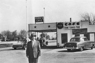
1954, Fern's Cafe Source.
Click image to enlarge
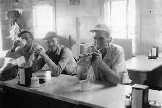
1954, Fern's Cafe Customers Source.
Click image to enlarge
The place has been torn down, below is a view from the 1950s. The two story home behind is still there, as you can see in this street view.
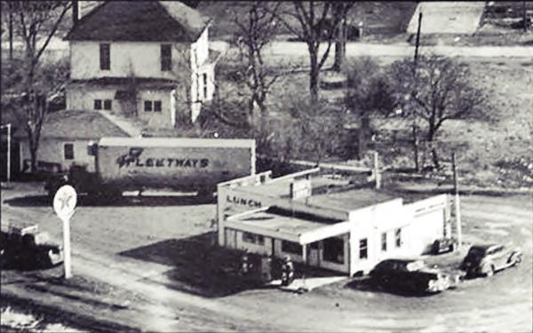
Henderson's Standard (gone)
Opposite Ferns, to your right, on the NW side of the four-lane highway (map showing the spot) was the site of Henderson's Dairy. It closed in 1942 during World War II. When Jerry Henderson (1923-2017) returned from serving during the war in 1945 he opened his Standard Service station with a small store in a gable roofed building. He closed it in 1963. The building survived (see it in the image below -red arrow) but now it has gone.
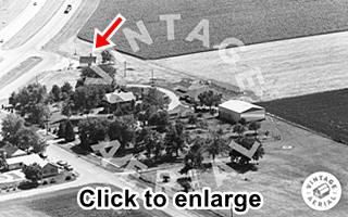
1971 view of Henderson's Standard. Source.
Click image to enlarge
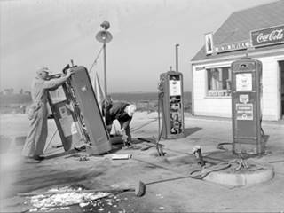
1948, Henderson's Standard Service. Source.
Click image to enlarge
The image above shows two men repairing the pumps at Henderson Service station that had been "damaged by hit and run truck," taken on May 19, 1948. Dangerous days on Route 66!
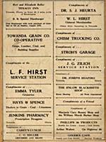
1941 Towanda businesses ads Source.
Click image to enlarge
There were many businesses in Towanda like L.F. Hirst's service station, J. G. Zilich gas station, Arthur Walton's Phillips 66 with ice cream, lunch and cold drinks "On Highway 66" all of which appear in a 1941 advertisement. Some of them were on the segment razed when the four lane alignment was built, and others were in downtown Towanda.
Continue your Route 66 Road Trip
This is the end of your Route 66 Roadtrip leg through Towanda. Head west along Old Route 66 and visit the next town in its alignment: Normal

Sponsored Content
>> Book your Hotel in Chicago

Credits
Banner image: Hackberry General Store, Hackberry, Arizona by Perla Eichenblat
Jack DeVere Rittenhouse, (1946). A Guide Book to Highway 66.


