Table of Contents
Index to this page:
- Illinois Route 66 Itinerary and maps
- Driving through Springfield
- Alignments split in Springfield
- From Springfield to Waggoner
- Into Litchfield along Historic Route 66
- Litchfield to Mt. Olive
- The final segments in Staunton, Livingston & Hamel
>> See our custom interactive Map of this segment.
Cities along the alignment
These alignments went through the cities listed below:
Springfield to Staunton (1926-30)
< West - Staunton ¦
Benld ¦
Gillespie ¦
Carlinville ¦
Nilwood ¦
Girard ¦
Virden ¦
Thayer ¦
Auburn ¦
Chatham ¦
Springfield - East >
The Main Alignment of Route 66 east of Hamel
<West - Hamel ¦
Staunton ¦
Livingston ¦
Mt. Olive ¦
Litchfield ¦
Waggoner ¦
Farmersville ¦
Divernon ¦
Glenarm ¦
Springfield
- East >

Sprngfield to Hamel Louis alignment
Illinois Route 66 Itinerary and maps
Each leg of Route 66 described below has an interactive map and many image maps so you can follow the alignments of the highway along the way:
- Chicago to Pontiac - Map of this segment.
- Pontiac to Springfield - Map of this segment.
- Springfield to Staunton (1926-30) - Map of this segment.
- This leg: Springfield to Hamel (1930-1977) - Map of this segment.
- Hamel to St. Louis - Map of this segment.
Missouri, next leg
Driving through Springfield
We describe this section of Route 66 starting on the north side of Springfield, and heading south into Springfield from Sherman. The original Route 66 had an alignment on the western side of the current highway that curved towards the Sangamon River. We describe this old section in our Sherman alingments page. The Springfield section begins on the southern side of Sangamon River.
1926 Sandhill section

1930 USGS Map of Route 66 roadbed (red line) and 1936 highway (dashed blue line)
From 1926 to 1936 the highway took a sharp right and then a sharp left to run along a very short section of Sandhill Rd., shown in the image and in this map with directions (see pink line in our customized interactive map). In 1936 it was eliminated by a straight segment (current Route 66 -dashed blue line in map), and after 1940 one mile after the bridge, US 66 split into the City 66 along N Peoria Rd. and the Bypass or Beltline 66 that forks off to the right, to the southeast.
Rittenhouse in his 1946 "Guidebook to US highway 66" wrote "The main route of US 66 passes through town, near the business district." This alignment is known as "City 66".
Bypass or Beltline 66
Shown in the custom map with a brown line in our custom map.
Route 66 was built in 1940, and ran along N Dirksen Pkwy, and then its Southern extension (at that time it was 31st Street). It carried US 54 part of the way. Then it turned west along Linn St. (now Stevenson Dr) to meet the City 66 on Sixth St. The southern tip was altered when I-72's Exit 94 was built. The Bypass' alignment at Adlai Stevenson was moved to its current position in the early 1960s. See this 1956 aerial photo showing the now lost original alignment at Exit 94.
The USGS map of 1958 shows US66 and I-55 enter Springfield from the south and part ways as US66 took the Beltway and I-55 was still under construction further east. They met again just north of Sherman as a "4 Lanes Dual" highway.
This is a Map with directions of the 9 mile Beltline.
Rittenhouse mentions it in 1946: "Leaving Springfield, By-pass 66 comes from the left."
Two Ghost Segments on City 66
The original road was upgraded in the 1950s to four lanes (as it is nowadays), and as it approaches the railroad underpass at Spring Creek, there are two old roadbed remains of past alignments:
1. By the Campground
See the pale blue line in our custom map.
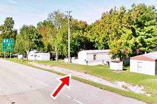
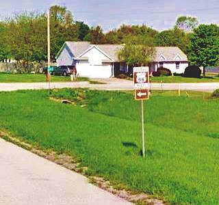
On the eastern side of the railraod, 1⁄4 mile from the railroad bridge, to your left, by the Campground, is a section of the original U.S. 66 with the 1926 roadbed (Pictured). The strip of concrete serves as a side drain next to the shoulder, directing water downhill. You can see it in this satellite view (red marker) and in this 1946 aerial photo.

1940 USGS Map and 1926 roadbed (red arrow)
2. On the south side of the highway
The eliminated segments at this point are marked with pale blue line in our custom map.
The surviving part of the second segment is shown in this map with directions.
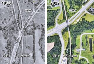
In the mid 1990s, the original alignment that curved as shown in our custom map, was modified when the Veterans Parkway was built: a "T" junction between North Peoria Rd and the parkway was built and the railroad underpass moved north, the curve was eliminated. Click on the thumbnail aerial views that show the same spot in 1956 and nowadays. For more details check this 1956 photo and the 2022 view.
Into downtown Springfield
Route 66 continues into downtown Springfield along N Peoria and 9th St.
See it marked with a navy blue line in our custom map, and in this 1926-77 City 66 map from the Sangamon River to the business district.
South of this point Route 66 took different alignments. We describe them below.
Alignments split in Springfield
The alignments in downtown Springfield:
Map showing all these alignments.
Maps with the different alignments of Route 66 through Springfield
These segments can still be driven:
> > 1926 - 1930 US 66 alignment in Springfield
> > 1930 - 77 US 66 alignment in Springfield
There were other realignments that we describe further down. The segments buried by the freeway are not shown on custom maps.
The 1926 US66 alignment out of Springfield
>> visit our 1926 Route 66 alignment from Springfield to Staunton webpage.
Route 66's original alignment across Springfield was aligned along State Highway 4 in 1926. Later in 1930 a new roadway was built, and US66 was realigned along it. They split in downtown Springfield.
The first alignment is marked with an orange line in our custom map of Route 66 in Springfield
Also see this map with directions.
As you can see it has many sharp 90° turns as it zig-zags its way across Southwestern Springield.
Finally at Woodside Rd. it crosses Lick Creek and headed towards Chatham (below is the original highway forking from Woodside Rd.)
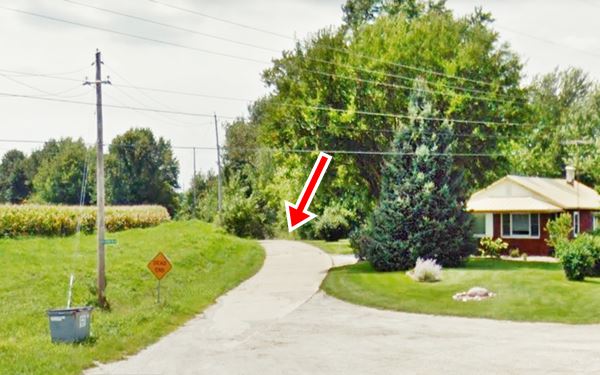
West of this point follow the alignment here: 1926 Route 66 alignment from Springfield to Staunton webpage.
The 1930 alignment
A newer and straighter highway

1929 roadmap south of Springfield (Credits
Click on Map to Enlarge
However the highway was realigned with a straighter course further east from Divernon to Litchfield and Mt. Olive. The work began in 1928, and as you can see in the thumbnail map (click on it to enlarge it), by 1929 The old IL-4 state highway was marked also as "T 66" ("temporary 66") while the construction work along former state highway IL-126 continued and part of the new US 66 alignment had already been built and paved: in the south to Litchfield and Raymond, and in the north to Glenarm.
1930-32 In downtown Springfield
During this short period of two years US 66 left 9th Street and turned west along E Capitol, and then south along 6th. heading out of town.
See the red line in our custom map
1932-1977
Then it was shifted back to 9th St. taking a right on S. Grand Ave. to leave town southwards along 6th Street. This is shown in our custom map with a blue line.
South of S Grand Avenue
Route 66 since 1930 went southwards along 6th Street, but later (1950s?) Sixth became a one-way street with a south-to-north direction so if you want to drive it, you will have take 5th St. southwards and then return (northbound) along Sixth.
Our custom map shows this alignment with a violet line.
From Stanford Ave. southwards, the original 6th St. Route 66 has been obliterated by the four lane divided highway (BL-55) built over 6th St. in the early 1950s. This 1946 aerial photo shows the wide "S-curve" of Route 66 at what is now Adlai Stevenson and 6th St.
See it marked with a yellow line in our custom map.
You can drive along 6th Street south of Adlai Stevenson. But before you reach the exchange between I-55, I-72 and BL-55 the old alignment vanishes, and is buried beneath the freeway. Head south to follow the old 1930-35 alignment into Lake Springfield:
South towards Cotton Hill
This alignment from Springfield was created along an existing secondary highway (IL-126) that ran between the state capital and Litchfield.
Cotton Hill
Pionners from Kentucky settled here in the mid 1830s and planted cotton, their cotton field on a hill gave the place its name.
The alignment to Glenarm followed Cotton Hill Road, and it is marked with a green line in our custom map. It begins on the eastern side of the freeway northwest of Toronto, and then curves to the south towards Sugar creek. It passes under the railroad tracks and then is cut off by Springfield lake: the last section is now submerged under the waters of man-made Lake Springfield created between 1931 and 1935.
The old road resurfaces on the south shore of the lake and runs with a general southern zig-zag direction until it turns west into Glenarm.
Sugar Creek Bridge (Gone)
The now submerged bridge (white line in our custom map) carried Route 66 in its 1930-35 alignment across Sugar Creek. The maps from 1924 and 2922 show the course of the highway on the northern and southern sides of Sugar Creek, before and after Lake Springfield was formed. The Red Arrows and red lines mark the alignment of Route 66 in both maps.
The lake was formed as a reservoir between 1931 and 1935.
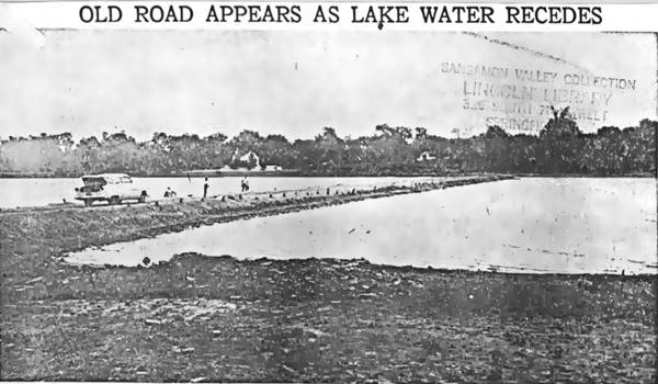
1930-35 US 66 viaduct at Sugar Creek reappears in 1954. Source
The original roadbed was visible during the terrible drought of 1952-55 that almost completely dried up the lake (see picture). The brick paved surface of the old Route 66 reappeared: "The road stretches all the way across the lake, except for a gap near the south end where a bridge spanned Sugar Creek before the lake was formed." (1)
See this map to Cotton Hill

USGS map (1924) showing what would be the 1930-35 alignment of US 66 south of Springfield in Cotton Hill

Current map showing flooded area (Lake Springfield) that cut the 1930-35 alignment of US 66 south of Springfield in Cotton Hill
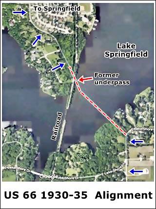
1930-35 alignment at Sugar Creek, Springfield
1935-77 alignment south of Springfield
New Bridge over Lake Springfield (Gone)
When Lake Springfield began filling up, the Sugar Creek Bridge on the 1930-35 alignment of Route 66 flooded, so a new one was built in 1932 to replace it.
This new bridge was a concrete girder T-beam bridge with decorative parapet walls. It carried Route 66 and, after the late 1950s, the southbound lanes of I-55. It was restored in 1967 and replaced in 2001.
It measured 1,540 ft long and was 50.9 feet wide.
Lake Springfield
The lake covers 4,260 acres (17200 ha.) and is Springfield's water reservoir. Set at 560 feet (171 m) above sea level it was formed when the Spaulding Dam was built across Sugar Creek in 1931-35.
1935 Realignment at Sugar Creek
Bypassing the flooded bridge, this new course ran straight south from Springfield into Glenarm, with less curves and the brand new bridge across the lake built in 1932.
By 1942, the wear and tear caused by wartime heavy traffic damaged the highway's pavement so the original 2-lane highway was to become a four-lane one. Construction of a 4-lane alignment began in 1943 and was finally completed in 1955. The bridge remained with 2 lanes. The original roadbed south and north of the bridge was torn up when I-55 was built here in 1967, but a short segment survives on the south side of the river:
Surviving "Marina" segment
Shown in this map with directions, a short section of the original road survives here as I-55 was built further east. It is the Water Edge Drive, and runs parallel to the lake's shore at the local Marina. You can see it in this 1956 aerial photo
Further south this 1950s "freeway" is named Palm Rd., it has a narrow grass median.
From Springfield to Waggoner
Route 66's original 1930-35 Alignment from Springfield to Glenarm
See the green line in our map.
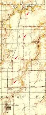
The highway followed state highway 126 from Cotton Hill to Glenarm (map with directions). The course is marked with red arrows in the map (click on the thumbnail map for a full sized view) IL-126 was an existing secondary highway that ran between the state capital and Litchfield.
The roadway resurfaces on the south shore of Lake Springfield and runs with a general southern direction with several sharp 90° turns as it heads west into Glenarm.
The thumbnail map is a USGS map published in 1924 and shows the roadway used by the 1930-35 alignment of US 66 from Springfield to Glenarm.
As it reaches Glenarm, the highway is cut by I-55 (no overpass links it to Glenarm), but when Route 66 became a 4-lane divided highway in 1950s, prior to the Interstate system, there was a junction at this point and in this aerial picture from 1946 you can see the junction at Glenarm. Here it took wide curve into a southbound course into Divernon, Farmersville and Waggoner.
1935 Realignment
The completion of the construction of Spaulding Dam across Sugar Creek cut the old road and a new and straighter alignment replaced the old one.
Looking west along the 1930-35 Route 66 in Glenarm, Illinois. I-55 runs from left to right in the background.
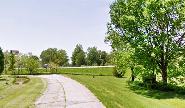
The later 1935-77 course from the Marina to Glenarm is now overlaid by the freeway.
From Glenarm to Divernon
Head south from Glenarm along Douglas St. which then becomes Frazee Rd (the West Frontage Rd.) and runs south till it meets State Highway 104.
To the south of Exit 82 at I-55 and IL-104 there is no Western Frontage Rd. and Old US 66 is buried under the Freeway. So here you must get on the freeway and get off it at Exit 80 to head into Divernon.
It is a 5 mile drive from Glenarm to Divernon (map with directions).
As you drive into Divernon there are brown-colored Historic Route 66 signs to guide you on your journey. But Route 66 never entered the town, it ran along its eastern side, now buried by I-55 or survives as its west frontage road in some parts. Rittenhouse wrote that the town was "a half mile to the west."
Old Roadbed
North side of Divernon is a dead-end segment, it is just 0.7 miles north of the town, next to the western side of the modern freeway.
This concrete-paved 0.8 mile-long segment belongs to the original 1930 alignment. There is a steel beam bridge on Bush Creek on this section that was built in 1949.
See this map with directions for the old segment.
1930 Route 66 roaddbed north of Divernon, Illinois
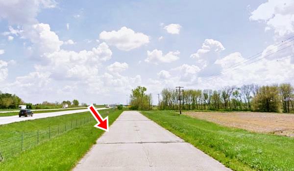
Follow this map with directions to reach it and drive it (it is not accessible from the W Frontage Road!)
Divernon to Farmersville
Follow the freeway south or take the West Frontage Rd. towards Farmersville.
South of Divernon, it is a 9 mile drive to Farmersville (map with directions).
Ghost segments in Farmersville
The 1930s and the later 1940 Route 66 is now under the W Frontage Road, but there are two ghost segments in Farmersville.
See the violet line in our map.
One is on the north side of Macoupin creek, the old Route 66 ran along Witt St. and headed south towards the creek. This is a dead end as the old bridge over the creek is gone.
Take the West Frontage Road that runs parallel to the old road. It crosses the stream with a bridge dating back to 1949 and visit the south end of this ghost segment.
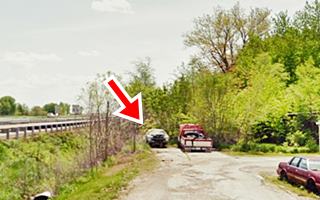
It is on the south side of Macoupin Creek, beside the Frontage Rd.; it has a Dead End sign:
Original roadbed of US 66 by Macoupin Creek, Farmersville, Illinois
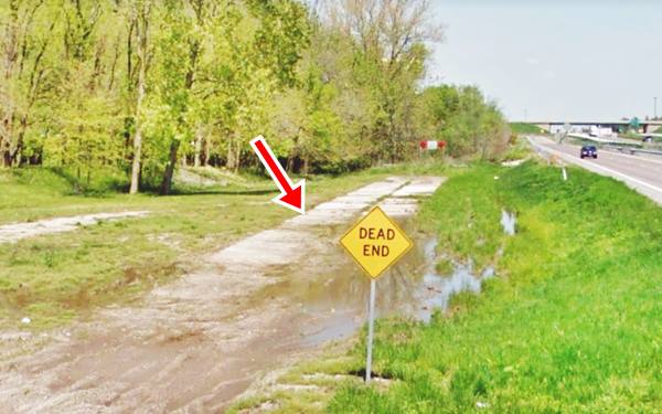
1930-1940 US 66 to Waggoner
The 1930 alignment was built along the "secondary route" that ran parallel to the tracks of the Illinois Central from North of Farmersville past Waggoner and on to Litcfield. It linked several schools and churches. See the 1925 Raymond USGS map.
This is the Map of 1930-77 of US66 from Farmersville to Waggoner.
The 1958 USGS map of Decatur shows a "Four Lane - Dual" highway between Waggoner and Litchfield shared by US 66 and I-55. This highway didn't have exits like them modern ones, they were, at that time just simple grade junctions and crossings without overpasses.
Into Litchfield along Historic Route 66
Bend at Coalfield Rest Area
Missing roadbed
From Waggoner to the rest areas south of the town, the original 1930 highway ran along what is now the West Frontage Road. The old roadbed became the southbound (SB) lanes of the four-lane alignment when two new northbound (NB) lanes were added in the 1950s. The Coaldfield Rest stop areas were built with the new I-55 when a new set of dual lanes were built on the eastern side of the old 4-lane US66. The rest area eliminated the original highway.
On the southern side of what is now the rest area, State Highway 126, and the 1930 Route 66 built along it, changed course and bent a bit to the west. You can see this in the map below and also in the aerial photo taken in 1956:
See the black line in our custom map.

The Bend and modern alignments (USGS map 1925)

The Bend and 4-lane 66 of the 1950s, 1956 aerial photo
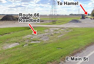
A 2022 view of this same spot reveals that the old roadway was removed, and grass grows where the highway once ran (satellite view).
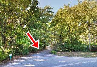
This alignment ran south and you can still see a portion of it at the entrance to the Our Lady of the Highways Shrine -see image below and satellite view. The 1956 aerial photo shows that this alignment ended here.
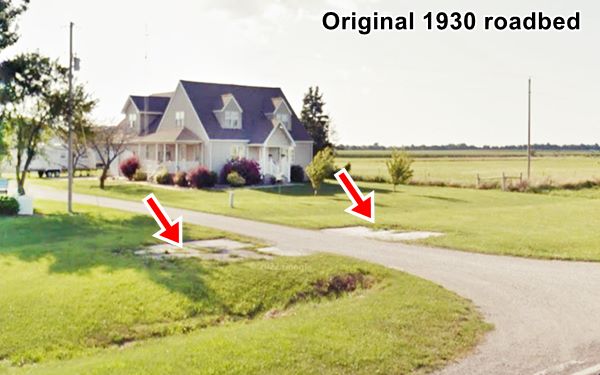
South towards Litchfield
Weigh Station at N 16th Ave
Southwards the old 1930s US66 continued straight along the W Frontage Rd. all the way to N 16th Avenue on the northern side of Litchfield. Here the railroad tracks take a NE-SW course and Route 66 changes its north-to-south course and runs parallel to the tracks.
The 1930s roadbed lay where the freeway is now located between N 16th and N 15 th Ave. The later 4-lane US66 ran between the tracks and modern I-55, the weighing station here has been here since the 1950s and was built between NB and SB lanes. The modern freeway and the rebuilding of the weigh station altered the roadbeds between N 15th and N 16th Avenues.
See the blue line in our map.
South of N 15th Ave
At N 15th Ave the original 1930 road moved closer to the tracks of the old Illinois and Wabash and you can still see its abandoned concrete roadbed because it became the SB lanes of the 1950s 4-lane highway. A new set of lanes was built between this roadway and the tracks as the NB lanes, and these are still in use as I-55 East Frontage Rd. The original road was abandoned when the freeway was built on its western side.
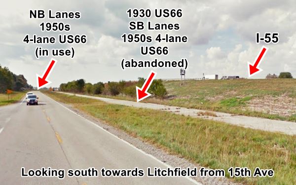
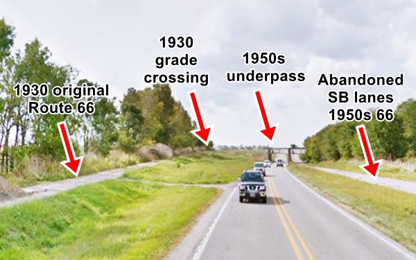
Just ahead the 1930 and the 1950s alignments cross, the original US 66 moves closer to the tracks of the Illinois and Wabash, to cross the tracks of the Central Illinois RR that comes from the north. There was a grade crossing here on the 1930s highway, but the four-lane alignment curved and passed beneath the Central Illinois tracks. The underpass is still here.
The 1930 US-66 followed the course marked with a pink line in our custom map. Both 1950s and 1930 roads met further south close to N 14th Ave.
Looking south: Original 1930s roadbed and the 4-Lane US66 heading towards railroad underpass, Litchfield IL.
South of N 14th Ave
After meeting the 1930s roadbed, and passing N 14 th Ave, the 4-lane alignment ran with a NE-SW course parallel to the tracks, and the original US-66 of 1930 seems to have ran where the current E Frontage Rd. is, they became the NB lanes of the 1950s US-66. The second set of lanes (SB) are still there as you approach Washington Rd. Beyond this point the 1950s roadbed splits from the 1930-40 highway.
Litchfield
Washington Rd. Alignment and the missing segment
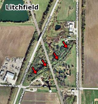
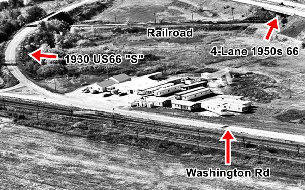
At Washington Rd. the 1930 Route 66 took a turn and ran south for 0.4 miles (Map with directions) and then took a wide "S" course to cross the tracks. The image below looks from the NE to the SW and you can see the original course along Washington Rd., several buildings stand on the western side of the highway.
Beyond, further west was the 4-lane 1950s alignment, and on the eastern side, the "S" of the 1930 Route 66 crossing the railroad.
See the purple line in our custom map.
The "S" alignment and the bridge across the tracks was removed in 1990. The Southbound lanes of the 1950s alignment were erased in the early 2000s; only the former NB lanes survive as "Historic Route 66"
This is shown with a yellow line in our custom map.
Adapted from an image by vintageaerial.com
See this Same view nowadays (3D Satellite image).
The map below shows the original curved Route 66 (1930) in red and the later alignment (dashed line), and the other image is a satellite view, today, where you can still see the trace of the old overpass marked by the red arrows.
This aerial photo taken in 1958 shows the different Route 66 alignments: The original 1930 one curve and the four-lane highway to the left.

USGS 1944 map of Route 66 on the north side of Litchfield
Here is where the highway now enters the city of Litchfield.
Litchfield to Mt. Olive
The different alignments in town

Route 66's 1930-40 and later alignments in Litchfield, Il. USGS 1944 map
Click image for full size map
1930-40 Alignment
The original alignment ran north to south across Litchfield along what is now known as "Old Route 66".
See the pale blue line in our custom map
Also see this map with directions.
1940-55 Route 66
Listed in the National Register of Historic Places
Route 66 from Litchfield to Mount Olive (1943-1955) is a historic highway.
The heavy traffic along Route 66 during World War II required a better, stronger and wider roadbed, so a new 24-foot wide and 10 inch thick, two-lane road in concrete was built in 1943 just to the west of the existing highway (the 1930 US 66); it ran along what is now Columbian Blvd.
The original highway carried the northbound traffic, and the new road became the southbound lanes.
The thumbnail map image shows a detail from the 1944 USGS map of Route 66 in Litchfield (click on it to see a full sized version). The alignment in bright red on the right is what we call the 1930-40 Route 66 or "Old Route 66" however it appears incomplete! There are several "missing" sections where the road does not appear on the map. We have marked them with a dashed red line. The map correctly marked the new alignment (deep red line) to the left.
The project called for a completely new four-lane road to be built, replacing the original Route 66, but it had to wait until the end of the war to be completed with four lanes along Columbian Blvd. (1956 aerial photo)

Route 66's 1930-40 alignment at Ariston Cafe, Litchfield, Il. Credits
Click image to enlarge
The picture is a view of the 1930 Route 66 running left to right in front of the famous Ariston Café, the newer alignment hadn't been built at that time. It runs only 150 ft behind the Café as you can see in this view showing the same spot nowadays. The curve to the right is IL-16 heading into downtown Litchfield. Route 66 runs towards the upper left corner.
The 1958 USGS map of Decatur shows a "Four Lane - Dual" highway north and south of Litchfield shared by US 66 and I-55.
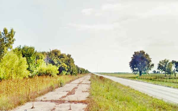
On the south side of Litchfield, the northbound lanes merge into the former southbound ones becoming a simple two-lane highway. The former northbound lanes are
closed to traffic, old slabs of concrete with weeds growing through the cracks. The old abandoned northbound lanes run all the way to Mt Olive next to the lanes that are still open to traffic.
See the green line in our custom map.
Looking south along the abandoned former northbound lanes of US66 between Litchfield and Mt Olive
Mount Olive
When the highway reaches the north side of Mt. Olive, the original 1930 Route 66 forks off to the left, parallel to the tracks while the 1940 alignment curves around the town to bypass it as a beltline road.
1940-77 alignment (abandoned northbound lanes) Route 66 north of Mt. Olive, Illinois
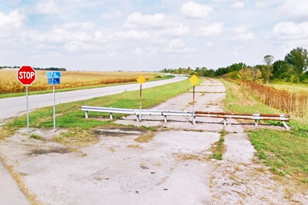
1930-40 US66 in Mt. Olive
This is the map with directions across Mt. Olive.
Four Lane 1940-77 Route 66
The later highway bypassing the business district had the algnment shown in this map and its surviving NB lanes are marked with a green line in our custom map.
They met on the south side of town, below is a view of the junction. The arrows mark the Historic four-lane Route 66 alignment (1940-77) and the 1930-1940 alignment forking off to the right into Mt Olive. The original northbound lanes are blocked off and can't be driven. The red circle marks the two official road signs of both alignments. Look for these brown signs on your journey, you won't get lost.
Fork of both US 66 alignments on the south side of Mt. Olive, Illinois
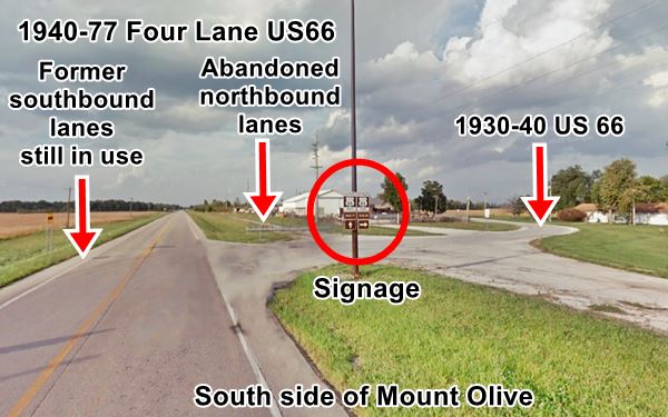
Our custom map shows the 1930-40 US-66 with a red line, and the now abandoned northbound lanes of the 1940-77 Route 66 with a light green line, at the north and south tips of the bypass.
South of Mount Olive
Just 0.7 miles after the junction of alignments on the south side of Mt. Olive, both alignments split again: the original 1930-40 highway heads to the right (it opened in 1928 and appears in the maps at that time though the official date is given as 1930), westwards towards Staunton while the later 1940-55 highway runs south towards Livingston along the eastern side of Williamson. We describe both alignments in the next section.
The final segments in Staunton, Livingston & Hamel
The alignments of Route 66 from Mt. Olive to Hamel
1926-30 Route 66
The original course of Route 66 from Springfield south through Chatham and several other towns (Auburn, Girard, Gillespie, etc), and Staunton.
We describe the Original 1926-30 Route 66 in a special webpage with maps and plenty of information
This first Highway 66 was aligned along Illinois state highway 4 (map with directions Staunton-Worden Wye) that came fron Benld and crossed Staunton's Business district.
1928-42 Route 66
Then, in 1928 the Illinois roadmap shows the original alignment renamed "T 66" or "Temporary 66", with a new one built between Staunton and Litchfield along former IL-16, named "US 66".
This alignment was completed in 1930, and remained in use until 1942. Temporary 66 was renamed IL-4.
The two roadmaps below, one from 1939, the other from 1942 show a significant change in Route 66's alignment between Mt.Olive and Hamel (Click on the images to see full size maps).
In the 1939 map, Route 66 runs between Mt Olive and Staunton, running along Staunton's eastern edge to meet IL-4 on the south side of the town. Then it took a southern course towards Worden Wye -named so due to the Y-shaped junction and from there, a SW course into Hamel.
By 1942, a new straight road had been built north from Mt Olive to Livingston in the south, and from there with a SW tack, to Worden "Y" (or Wye).
This is a map from southern Mt. Olive to Staunton. The highway is almost the same except for the intersection of Route 66 with East Main St. (Staunton Rd.) It was a very sharp angled crossing not a "+" but more like an "x" so it was rebuilt in the early 1980s to make it safer. Compare this 1956 aerial photo with
its current appearance. The picture shows a cracked slab of the original concrete highway at the crossing.
See the
red line in our custom map
The highway skirted around Staunton's eastern flank and met IL-4 roughly 2.5 miles south of downtown Staunton. Junction pictured below:
Route 1926-28 and 1928-42 alignments meet south of Staunton, Illinois
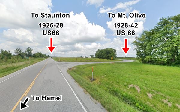
IL-4 and Route 66 ran south from this point for 3 miles to Worden's junction at Possum Hill Road.
Route 66 realigned in 1942
1942 to 1977 US66
The stretch through Staunton was replaced by a straighter course to Worden Wye junction via Livingston in 1942. This was originally a 2 lane highway that became a 4-lane divided highway after WWII.
Starting at the fork of the 1928-42 US-66 towards Staunton south of Mt. Olive you can spot an abandoned segment of the northbound lanes of the 4-lane 1942-77 US-66, we marked it with a blue line in our custom map.
Ahead the interchange at I-55's Exit 41 disrupted the old roadbed (black line in our map) but the original southbound lanes are still there as the W Frontage Rd,
and run all the way to Exit 37 (map with directions) at Livingston.
They are cut by the interchange, but resurface on its southern side (green line in our custom map) and run from there straight as the W Frontage Rd. all the way to Worden Wye (after the "Y-shaped" junction) at Possum Hill Road (see this map Livingston-Worden Jct.)
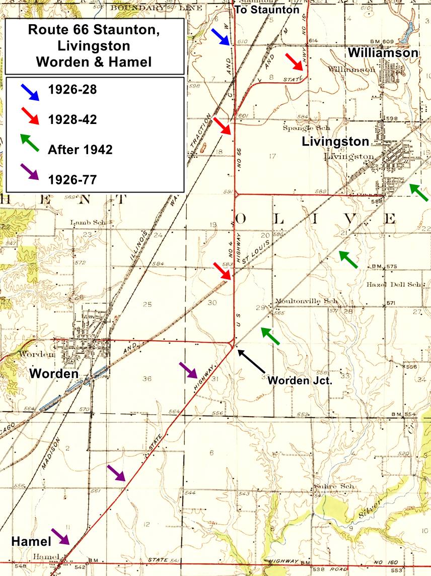
The USGS map shown below was printed in 1932 and it shows Route 66 to the west of Livingston:
North of Worden Jct., the map shows the original alignment south of Staunton (blue arrow), the 1928-42 Route 66 (red arrows) and the course that Route 66 would follow after 1942 (green arrows). West of Worden Jct, to Hamel, the violet arrows mark the course of Route 66 from 1926 to 1977.
Alignments split in Hamel
The interchange at Exit 33 disrupted the old junction of IL-4, Possum Hill Rd. and Route 66. This is a map from the junction to Hamel.
In 1954, Route 66 was supposed to split into two alignments just north of Hamel at its junction with Possum Hill Rd. that leads to the town of Worden, 2 miles west. The map below and this 1955 aerial photo show the junction; in the photo you can see the work on the new roadway that now carries I-55.
The 1954 map shows US 66 reaching the junction (upper right) from Livingston, and BYP 66 leaving it (lower left) the Bypass 66 went around St. Louis via Edwardsville and Mitchell IL; the blue arrow shows Main 66 (that would reach St. Louis MO via Collinsville). However, when the fork was built, it was located further south, at Green Hedge Rd. (the new "Main 66" hadn't been built in 1954 when the map was made). Later I-55 was aligned along this "new" roadbed.

1954 Map of US 66 near Worden, north of Hamel IL

1954 Map of US 66 alignments in Hamel IL
The map above shows the highways in Hamel: The original 1926-54 Route 66 ran through Hamel and in 1954 became the "Bypass 66", the new alignment on the right side of the map (further east) became the Main US66.
Next Section
>>The next section in our Road Trip itinerary is Hamel to St. Louis
Book your Hotel
Sponsored content
>> Book your Hotel in Springfield Illinois

Credits
Banner image: Hackberry General Store, Hackberry, Arizona by Perla Eichenblat
Registration form Route 66 Litchfield to Mount Olive NPS
Jack DeVere Rittenhouse, (1946). A Guide Book to Highway 66


