Route 66 in Los Lunas NM
Index to this page
About Los Lunas, New Mexico
Facts, Trivia and useful information
Elevation: 4,856 ft (1,480 m). Population: 20,256 (2025).
Time zone: Mountain (MST): UTC minus 7 hours. Summer (DST) MDT (UTC-6).
Los Lunas is a village in Valencia County NM on the Rio Grande.
People have lived in this area for at least 10,000 years. Their descendants, Native American Pueblo people settled in the valleys of the rivers that flowed into the Rio Grande. During the last few thousands of years
Seeking the "Cities of Gold", the Spanish explored the area for the first time in 1540, when Francisco Vásquez de Coronado named the native people "Pueblo", after the Spanish word for "village".
Almost sixty years later Spanish returned to claim the territory, and settled in Santa Fe in the early 1600s; they built missions in the pueblos and converted the natives to Catholicism but opressive forced labor imposed by the "encomienda" system used by the Spaniards led to an Indian uprising in 1680.
The natives razed the colony in 1680. The missions, haciendas, and towns were destroyed.
The Spaniards returned in 1692, defeated the rebels and resettled the area, founding Albuquerque in 1706 as a key stopover on the Camino Real (Royal Road) that ran south into Mexico City.
What is now Los Lunas was granted to Felix Candelaria in 1716 as part of the San Clemente Land Grant. Later the Luna family claimed and obtained possession of the grant. A community formed around their estate.
Origin of the name Los Lunas
The original settlers here were the Luna family (Luna is Moon in Spanish), who were known as "Los Lunas" (The Lunas"). The crescent moon was a good luck charm and a symbol of greatness, and adopted by the original Luna nobles from Aragón, Spain.
After its independence from Spain in 1821, New Mexico passed on to Mexico for twentyseven years, but it ceded the territoryto the U.S. after its defeat in theMexican - American War (1846-48).
Fort Los Lunas was established in 1852 by Capt. Richard S. Ewell of the First Dragoons following orders from Col. Edmond Vose Sumner. His mission was to set up a post here (or in Sabinal) with "good winter quarters". Ewell rented quarters, land, and farmed the forage for his horses. It became a post -not a fort- until it was abandoned in 1860.
Valencia county was also created in 1852 and its county seat moved to Los Lunas in 1876. The Atchison Topeka and Santa Fe Railroad arrived in 1882 and built a depot.
In 1926 Route 66 was aligned through the village following the National Old Trails Road and in 1928 the village incorporated. In 1931 the highway was realigned along the west bank of the Rio Grande. But in 1937 US 66 was realigned further north, with a westwards course from Albuquerque to Laguna. This "Laguna cut-off" shortened the road towards Gallup bypassing Los Lunas.
Accommodation in Los Lunas
There is lodging in Los Lunas and also in neighboring Isleta and Albuquerque:
> > Book your Hotel in a Albuquerque, Isleta or Los Lunas
More Lodging close to Los Lunas on US 66
Below you will find a list of some of the towns along Route 66 in New Mexico. Click on any of the links to find your hotel, motel or accommodation in these towns (listed from east to west):
On Route 66's Main alignment
The Santa Fe Route 66 segment
Eastwards
Westwards
>> There are RV campgrounds in Los Lunas
The weather in Los Lunas
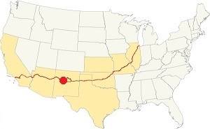
Los Lunas on Route 66
The climate in Los Lunas is sunny (278 sunny days per year) and very dry (very low relative humidity).
The high elevation and the dry air provoke large swings between day and night temperatures, even in summer.
Average High ⁄ Low Temperatures during summer (Jul.) are: 92 ⁄ and 65 °F (33 ⁄ 18 °C). The average during winter (Jan) are: 47 ⁄ and 24 °F (8 ⁄ -4 °C)
Summers are hot and winters are relatively cold. Rainfall tends to fall during the summer monsoon season (July through September), and adds up to about 11 in. per year (279 mm). Shielded by mountains to the east, snowfall is quite low: about 10 inches (25 cm) per year.
Tornado risk
Tornado risk
The tornado risk in Los Lunas is nil: Valencia County has no Tornado watches.
Tornado Risk: read more about Tornado Risk along Route 66.
Map of Route 66 in Los Lunas, NM
Read the Detailed Description of this segment (Albuquerque to Lupton). Below is the interactive map:
>> Custom map of Route 66 in Los Lunas
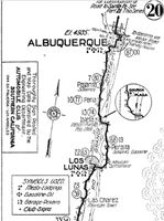
1916 N.O.T. Road map, Los Lunas
Click on image to enlarge.
Source
Check out our interactive custom map: the orange line shows Route 66's 1926-31 alignment coming from Peralta and crossing the Rio Grande into Los Lunas. It continues west as the 1926-37 roadway. The red line south of Isleta is the 1931-37 realignment along the west side of the Rio Grande from Isleta to Los Lunas, bypassing Peralta.
The original Route 66 was aligned through Los Lunas in 1926 along the "National Old Trails". See the 1916 National Old Trails (N.O.T.) map from Albuquerque to Los Lunas (click to enlarge it). Los Lunas offered meals, lodging, supplies and gasoline.
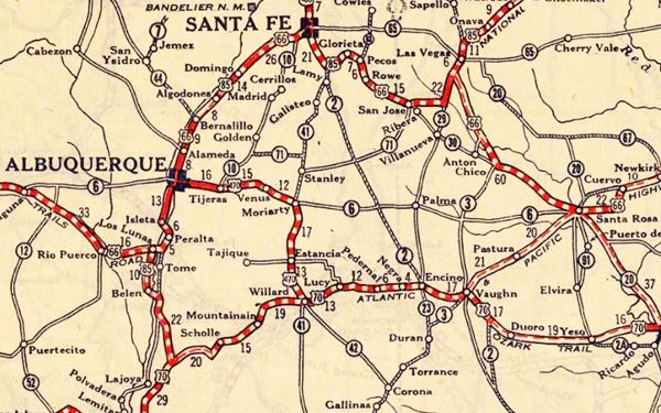
These highways were known as "Auto Trails" and part of a public demand for "better roads": a movement that lobbied for good highways that could be used by motor vehicles, and also signs to mark them and help drivers to find their destination. New Mexico authorities improved the original Ozark Trail in 1914 and designated it as New Mexico State Highway 3. The thumbnail map (Click to see large size map), shows some of the "Auto Trails" that could be used by cars in 1912 in the area near Los Lunas on the map's lower middle right side; the trails are marked with red lines.

1912 Road map, western NM
Click on image to enlarge.
Source

1925 Road map, western NM
Click on image to enlarge.
Source
The second thumbnail map above from 1925 (click on it to see the full sized map) shows the roads that existed one year before Route 66 was created.
Those marked "22" (National Old Trails Rd., coming from Los Angeles) and "32" (New Santa Fe Rd.) with white letters in a black box, went from Gallup to Albuquerque and through Santa Fe. Highway "50" was the Ozark Trails.
The only paved sections (full black line) were between Isleta to Albuquerque and north to Bernalillo, and Albuquerque and Tijeras. The highway from Bernalillo to Santa Fe, and beyond Isleta was "improved" (dashed line), the rest were either graded or dirt roads. Los Lunas appears on an improved segment of Route 66 on the lower right side of the map.
Route 66's original alignment
North of Los Lunas, the 1926 alignment of US66 crossed the river to its eastern side at Isleta and went south, going through Peralta. South of this point it crossed the Rio Grande again into Los Lunas.
From here it headed and ran close to the Atchison Topeka and Santa Fe railroad tracks climbing out of the Rio Grande Valley, curving towards Suwanee.
1931 realignment
See the red line in our custom map.
US 66 was paved by 1928, and it was realigned along the west bank of the Rio Grande in 1931 to shorten its course and remove the two additional crossings of the Rio Grande river south of Albuquerque's Barelas Bridge. This realignment bypassed Peralta (what now is NM-47 used to be US66).
1937 Laguna Cut Off
The new bridge across the Rio Grande in Albuquerque just west of Old Town was completed in 1931 and funding was secured for a bridge across the Rio Puerco further west of ABQ, which was built by 1933 paved the way to another realignment.
Cut Off
The "Laguna Cut-Off" is named after the Laguna Mission village west of ABQ and Los Lunas. In 1937 the whole highway was moved north. It used the new bridges across the Grande and Puerco rivers and climbed out of Albuquerque westwards with a straight course towards Suwanee, Mesita and Laguna. Both Isleta and Los Lunas had been cutoff for good.
Los Lunas is on the middle left side:
Route 66 Alignment near Los Lunas
With maps and full information of the alignments of Rte. 66.
- Albuquerque to Lupton (next)
- Santa Rosa to Albuquerque 1937-85 and Santa Fe Loop 1926-37 (parallel alignments)
- Tucumcari to Santa Rosa (previous)
The Santa Fe Loop (1926 - 1937)
Our Santa Fe Loop page describes the complete 1926 to 1937 alignment of Route 66 from Santa Rosa to Albuquerque through Pecos, Santa Fe and Los Lunas.
Los Lunas, New Mexico: Attractions & Sights
Los Lunas Landmarks
Drive to Los Lunas from either Isleta (1931-37 alignment) of Peralta 1926-31 road. We will choose the latter; Peralta.
Starting in Peralta head south. The highway reaches Valencia, now a part of Los Lunas.
Valencia
It appears as a "Mexican Settlement" in the N.O.T. map from 1912. this area was settled by Francisco de Valencia, around 1630. The Pueblo Revolt of 1680 expelled them for good, but their name remained. Valencia is a family name comes from the place name Valencia, quite common in Spain. It originated from the Romans who used it for their fortifications and it combines the Latin word "Valentia" that means courage or strength.
Sangre de Cristo Catholic Church
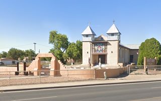
The first chapel was built here around 1801 and named "Blood of Christ" (Sangre de cristo). It was recorded as a mission of the Tomé parish in 1821. It was upkept over the years until a wall collapsed in 1941. The original building was razed and rebuilt with adobe on concrete foundations and reopened in 1946.
There is a Historic Marker in front of the church telling the story of Valencia.
Rio Grande Bridge
Ahead the highway curves westwards to cross the Rio Grande along "Main Street Bridge". The current bridge replaced one built in 1974, that in turn replaced the original 1920s bridge built to carry NM 6 highway. The first bridge here was built in timber in 1890 by Valencia county but the river cut its access shortly after .
Huning Mercantile
After 1⁄2 mile, to your right, is the original Huning Mercantile store. The company operated from 1860 until 1994 and sold products to farmers, ranchers and those traveling along Route 66.
It began when brothers Louis and Henry established L & H mercantile. Louis took control in 1888 renaming it Huning Mercantile. The town's first post office was located in this building. It remained in the family until the death of Louis' grandson, Fred Sr. and after his death in 1993, the store closed, but the Company has other interests and is still operating.
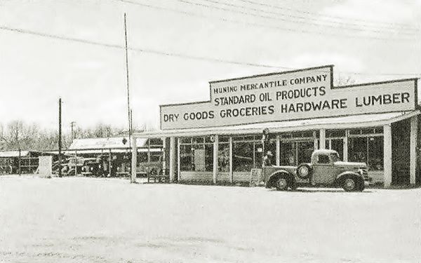
Some now gone landmarks here are the U and I Cafe and Diner on the corner of Don Diego St. and Main thag was owned and operated by Antonio Archuleta. The Castillo General Merchandise on S. Las Lentes and Main was established by Emiliano Castillo in 1918. He had been brought up the the Huning's and spoke German and English, he was also the town's mayor an his son Emiliano Jr. also held the same office.
Site of the Hanging Tree
On the next block (460 Main St. NE, to your right) where Los Lunas public library stands, was the site of the local hanging tree, taken down in the 1960s it had a "hanging limp" that jutted out over the roadway. It was considered haunted by the locals.
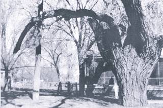
Hanging Tree with its "hanging limb". Source
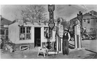
Aguirre Service Station with its owner and dog Fifi. Source
Aguirre's Service Station (gone)
Just before you cross the railroad, to your right, where the dental clinic now stands, was the two story, red brick, hip-roof county court house built in 1913. It was torn down in the 1950s. Next to it was a gas station owned and operated by Climaco Aguirre. He also sold tires and batteries. He was the town's Court Clerk and also sold licenses to the local residents. He is seen in the image above with the Courthouse in the background and his dog Fifi. Nothing remains of it.
The 1926-31 alignment crosses the railroad tracks with a grade crossing and meets the highway running parallel to the railroad with a North-South Direciton. This road was paved and became the 1931-37 Route 66 alignment from Isleta into Los Lunas (Modern NM-314). Here at Main St. it turned sharply westwards, along Main St. and there were two gas stations on the intersection. Only one survives.
Historic Otero Phillips Gas Station
Listed in the National Register of Historic Places
Main St. and NM-314, Los Lunas, on the NW corner of the busy junction, this former Phillips Service Station dates back to 1923. It is still standing, without its pumps or their concrete bases, although their outline can still be seen in front of the building (see image below).
Historic Phillips Gas Station in Los Lunas, NM
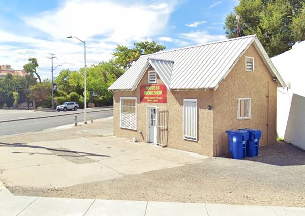
The cottage style building has a "domestic" appearance, designed to blend in with its urban surroundings. Following the realignment of U.S. 66 in 1937, U.S. 85 continued to pass along the east side of the property, along what is now NM 314, and the service station continued to operate for many years.
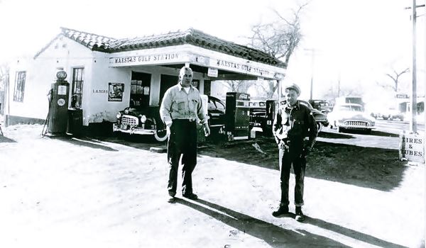
Maestas Gulf Station (gone)
Across the street, on the SW corner, where the Blake's Lotaburger is now located. It was owned and ran by E.J. Maestas.
The Luna Otero Mansion
Listed in the National Register of Historic Places
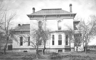
Late 1800s Luna Mansion. Source
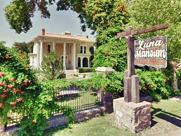
Continue west along Main St. (the 1926-37 Route 66), at 110 W. Main St, Los Lunas, to your left on the south side of the highway is an imposing mansion from the late 1800s.
The Luna-Otero Mansion was built back in 1881 as a gift from the Atchison Topeka and Santa Fe Railroad to the Luna-Otero family in exchange for them having granted the right of way for the railroad tracks. It is pictured below. The railroad alignment required razing the original hacienda of the Luna family and $13,000 were paid so that the family could buiild their new home.
It has been preserved and. Originally built in Victorian Southern Colonial style in adobe.
The Luna Otero Mansion in Los Lunas, NM
Acoma Service Station and Motel (Gone)
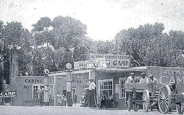
Adjacent to the mansion, also to your left, there is a parking space where the Jesus Gallegos operated the Acoma Service Station and cabins. It offered a "Square Deal... 25¢ Last Chance" to fill your tank. He started with a grocery store next to his home, then added a garage, gas station and cabins, that went for $2 a night. Nothing remains of the site, even their home, on the west side of the property has been torn down. Below is a vintage view of the spot, and this is the St. view.
White Cafe
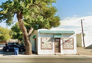
Across the street facing the mansion on the west side of Otero's station, is the old White Cafe. It began as the White Hotel (now gone) built in 1922 and owned my Miss P. Romero. It suffered a fire around 1928 and was rebuilt, and a cafe was added. The hotel is gone, but the cafe survived. It has been registered as a NM state historic property and owned by one of the long-time village families, the Romero.
Next to it is the Wittwer House, currently Teofilo's Restaurant. It is a National and NM state registered property. Built between 1904 and 1917 it was the home of the local physician Dr. Wittwer.
American Camp (gone)
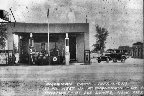
Further west along Route 66 there was another (the last!) gas station with cabins, American Camp on Los Lunas Prairie it was owned by Sam Gonzalez in the 1990s. During the days of Route 66 it provided cabins, supplies and gasoline for travelers.
Westwards from Los Lunas to Suwanee
This alignment is marked with an orange line in our custom map. As you can see, in some places it deviates from the course of the current roadway in several spots. The modern highway was realigned in the 1940s, after it ceased to be Route 66.
West of Los Lunas the original roadway ran around the north side of the Amazon warehouse as a dirt road, and then after crossing the railroad with a grade crossing (as shown in our custom map).
Ahead it heads south in a wide curve away from the modern alignment. At the point where it meets the current alignment you can spot the abutements of a 1920s bridge to your left (pictured below; orange marker in our map).
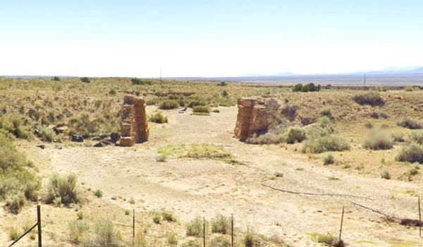
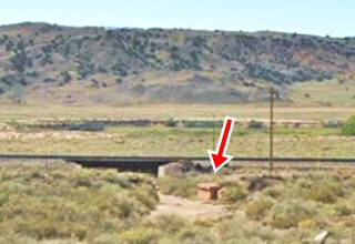
Ahead, it forks again to the south in a curve with another gone bridge whose abutements have survived and can be seen to your left (See picture and the red marker in our map).
Ahead both alignments converge and the highway crosses the rio Puerco river. Just ahead is the famous and controversial Los Los Lunas Decalogue Stone.
Los Lunas Decalogue Stone
Located south of the highway (NM-16) 1⁄4 mile after crossing Los Lunas (see this Map with directions that can be driven, then it is a walk of 1 mile along a rought trail to the stone: this is a Map showing exact location of the Decalogue Stone.
Also known as the Los Lunas Mystery Stone or Commandment Rock it is supposed to be a version of the Ten Commandments written in "Paleo-Hebrew" that is similar to Phoenician.
First reported in 1933 by Frank Hibben (1910-2002) an archaeologist from the University of New Mexico who said he was guided to the site by a person who had discovered the stone in 1880, when he was a child.
Los Lunas Decalogue Stone in Los Lunas, NM
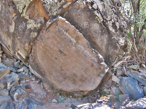
The boulder is said to weigh 80 tons, and had nine lines (now eight after the first line was defaced in 2006) of inscriptions chiseled into its flat face.
Some scholars support the version that it is pre-Hispanic and therefore the work of Semites who reached America in the distant past.
However its location on an insignificant hill, distant from the sea, farmland, villages, and a reliable water sources does not support the likelyhood of it being a ceremonial site. Furthermore, the symbols inscribed on the stone are confusing.
The text combines Phoenician forms from 1,100 B.C. with Samaritan forms from 600 AD and it also includes Greek letters.
The clean surface lacking the patina of age and lichens gives it a modern appearance.
It certainly a hoax, a forgery which was probably done by Hibben or by the "Mormon Battalion" that took part of the Mexican - American War and was in the area at that time. The Mormons at that time adopted the theory that a group of Israelite people visited America in Pre-Columbian times.
The stone is located on New Mexico state trust land so as indicated here, in their website: www.nmstatelands.org: To access State Trust Lands you must purchase a recreational access permit from the New Mexico State Land Office. Permits cost $35, are good for up to 10 people, and are valid for one year.
Route 66 heads west to Suwanee
Return to the main alignment, ahead there is another deviation of the original roadway orange line in our map, as it climbs a steep hill.
It runs towards Suwanee, where it meets the later alignment adopted in 1937 (teal line.
End of this leg of your Road Trip
This is the end of your journey through Los Lunas, now continue westwards along main alignment (post 1937) here in Suwanee head west into Mesita.
El Cerro Tomé Hill
Listed in the National Register of Historic Places
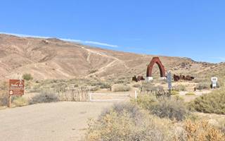
El Cerro Tomé Hill, Los Lunas NM. St. view
Located on Sand Hill Rd. See this Map with directions.
This strategic hill served as religious site, lookout, and refuge from floods and invaders, its volcanic summit stands 400 ft. above the Rio Grande valley's floor.
Next to the parking area at the foot of the hill is the "La Puerta del Sol" (Gateway to the Sun) a steel sculpture by Armando Alvarez that celebrates the different cultures that blend in the Rio Grande Valley. It is the 10-acre park including the hill; with picnic tables and also a self-guided tour to the prehistoric petroglyphs.
There are over 1,800 petroglyphs (symbols and inscriptions engraved in stone) up to 2,000 years old. The hill's summit offers a great panoramic view and is studded with crosses, the destination of many pilgrims. There is also a masonry shrine atop the hill. It is open year round.
Named for the neighboring village of Tomé founded in 1739 (after Tomé Domínguez de Mendoza who settled there in 1659).
The Church of the Inmaculate Conception at Tomé Village has a museum with hand-carved wood saints.

Sponsored Content

>> Book your Hotel in Albuquerque

Credits
Banner image: Hackberry General Store, Hackberry, California by Perla Eichenblat


