Route 66 in Isleta NM
Index to this page
About Isleta, New Mexico
Facts, Trivia and useful information
Elevation: 4,862 ft (1,482 m). Population: 931 (2025).
Time zone: Mountain (MST): UTC minus 7 hours. Summer (DST) MDT (UTC-6).
Isleta is the an unincorporated community in New Mexico, located in Bernalillo County, NM on the Rio Grande River, south of Albuquerque.
History
People have lived in this area for over 10,000 years. Later the Tiwa people settled in the valleys of the rivers that flowed into the Rio Grande. Isleta itself dates back to the 1300s.
Seeking the "Cities of Gold", the Spanish conquistadors explored the area from their base in the Viceroyalty of New Spain (current Mexico), and in 1540 Francisco Vásquez de Coronado named the native people "Pueblo", after the Spanish word for "village."
The Spaniards called this pueblo "Isleta" (little island).
Origin of the name Isleta
This Tiwa pueblo was first spotted by the Spaniards in 1540 and it was located on a small island in the Rio Grande ("Islita" in Spanish - also "Isleta").
The local Tiwa name for the village means "flint kicking place" while the Navajos called by a name meaning "Tribe by the water". Spanish Governor Otermin in 1692 called it "La Isleta" (The little island).
Following Coronado's incursion, the Spaniards left New Mexico alone for 50 years but returned in 1598 to settle the province. They set their capital in Santa Fe in 1610 and began a process of converting the natives to Catholicism by building missions. These also helped concentrate them in defined places where their labor could be used by the Spanish. Isleta's mission was established in 1629 and named "San Agustín de la Isleta by the Franciscan friar Juan de Salas.
Spanish opression and religious persecution led to a rebellion in 1680 during which the natives destroyed the colonial towns and missions. Some of the inhabitants of Isleta fled to El Paso with the Spaniards and some went west to the Hopi villages in Arizona.
The Spaniards returned in 1692 and its leader, De Vargas subdued the rebels and resettled this area, founding Albuquerque in 1706 as a key stopover on the Camino Real (Royal Road) that ran from Santa Fe to Mexico City.
Isleta, in ruins, was resettled in 1710 and the church was rebuilt in 1716 (once again as San Agustín or St. Augustine).
After its independence from Spain in 1821, Nuevo Mexico passed on to Mexico but it was ceded to the U.S. who won the Mexican - American War (1846-48).
The post office opened in 1882 and closed shortly after, reopening in 1887, at that time the Atchison Topeka and Santa Fe Railroad reached Isleta, and built a depot there.
Route 66 was aligned through the town in 1926, on the old Camino Real and the National Old Trails highway, which ran close to the railroad from Laguna to Isleta. In 1937 it was realigned here due to the "Laguna cut-off" that shortened the road bypassing both Isleta and Los Lunas (neighboring Peralta had already been bypassed when the road was realigned on the western side of the Rio Grande in 1928).
The 1937 USGS map of the area shows Barelas Bridge in Albuquerque and a few scattered houses at "Five Points" south of Atrisco and at Armijo. In that map, Route 66 runs with US 85 through irrigated farmland all the way to Isleta.
The people of Isleta, which are Tiwa are federally recognized as a Native American tribe.
Accommodation in Isleta
There is lodging along Route 66 in Isleta and nearby in Albuquerque:
> > Book your Hotel in a Albuquerque, Isleta or Los Lunas
More Lodging close to Isleta on US 66
Below you will find a list of some of the towns along Route 66 in New Mexico. Click on any of the links to find your hotel, motel or accommodation in these towns (listed from east to west):
On Route 66's Main alignment
The Santa Fe Route 66 segment
Eastwards
Westwards
>> There are RV campgrounds near Isleta in Albuquerque.
The weather in Isleta
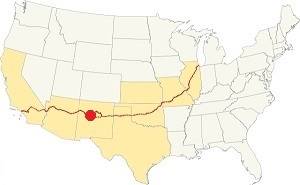
Isleta on Route 66
Isleta is located in the Rio Grande Valley; its climate is sunny (278 sunny days per year) and very dry (very low relative humidity).
The high elevation and the dry air provoke large swings between day and night temperatures, even in summer.
Average High ⁄ Low Temperatures during summer (Jul.) are: 92 ⁄ and 65 °F (33 ⁄ 18 °C). The average during winter (Jan) are: 47 ⁄ and 24 °F (8 ⁄ -4 °C)
Summers are hot and winters are relatively cold. Rainfall tends to fall during the summer monsoon season (July through September), and adds up to about 11 in. per year (279 mm). Shielded by mountains to the east, snowfall is quite low: about 10 inches (25 cm) per year.
Tornado risk
The tornado risk in Isleta is nil: Bernalillo County has no Tornado watches.
Tornado Risk: read more about Tornado Risk along Route 66.
Map of Route 66 in Isleta, NM
Read the Detailed Description of this segment (Albuquerque to Lupton). Below is the interactive map:
>> Custom map of Route 66 in Isleta.
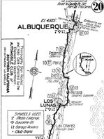
1916 N.O.T. Road map, Isleta
Click on image to enlarge.
Source
Check out our interactive custom map: the orange line shows Route 66's 1926-37 alignment into Isleta. The red line south of it is the 1931 realignment along the west side of the Rio Grande to Los Lunas.
The original Route 66 was aligned through Isleta in 1926 along three previous highways, the "Ozark Trail", the "Santa Fe Trail" and the "National Old Trails". See the 1916 National Old Trails (N.O.T.) map from Albuquerque to Los Lunas (click to enlarge it). The highway crossed Isleta by the church and main square or plaza. Only Peralta and Los Lunas had garage, gasoline and meals-lodging.
These highways were known as "Auto Trails" and part of a public demand for "better roads": a movement that lobbied for good highways that could be used by motor vehicles, and also signs to mark them and help drivers to find their destination. New Mexico authorities improved the original Ozark Trail in 1914 and designated it as New Mexico State Highway 3. The thumbnail map (Click to see large size map), shows some of the "Auto Trails" that could be used by cars in 1912 in the area near Isleta (map's lower middle right side); the trails are marked with red lines.

1912 Road map, western NM
Click on image to enlarge.
Source

1925 Road map, western NM
Click on image to enlarge.
Source
The second thumbnail map above from 1925 (click on it to see the full sized map) shows the roads that existed one year before Route 66 was created.
Those marked "22" (National Old Trails Rd., coming from Los Angeles) and "32" (New Santa Fe Rd.) with white letters in a black box, went from Gallup to Albuquerque and through Santa Fe. Highway "50" was the Ozark Trails.
The only paved sections (full black line) were between Isleta to Albuquerque and north to Bernalillo, and Albuquerque and Tijeras. The highway from Bernalillo to Santa Fe, and beyond Isleta was "improved" (dashed line), the rest were either graded or dirt roads. Isleta on the lower right side of the map.
Route 66's original alignment
U.S. Highway 85 boasts that it is the "oldest highway in America" because it runs along the Camino Real. (Route 66 did so too, from 1926 to 1937).
The first alignment of Route 66 established in 1926, avoided the desert crossing from Santa Rosa to Moriarty, instead it took a wide curved north towards Las Vegas NM, and then passed through Pecos and the state capital, Santa Fe, curving south into Albuquerque (the final part is shown with a yellow line in our map; for the full alignment see the Santa Fe Loop map.)
From here it went through the southern Barelas district to cross the Rio Grande River along the Barela Bridge at a place where in the past was the ford of the Camino Real.
On the west side of the river were the scattered houses at Armijo and the remains of some motels. Here the road turned south along the west bank of the river, among irrigation ditches or "acequias" and after 10 miles it reached Isleta.
At Isleta, the highway crossed the river again, going through Peralta and then, for the third time crossed the Rio Grande into Los Lunas.
From here it headed and ran close to the Atchison Topeka and Santa Fe railroad tracks climbing out of the Rio Grande Valley, curving towards Suwanee.
1931 realignment
See the red line in our custom map.
US 66 was paved by 1928 and it was realigned along the west bank of the Rio Grande in 1931 to shorten its course and remove the two additional crossings of the Rio Grande river south of Albuquerque's Barelas Bridge. This realignment bypassed Peralta (what now is NM-47 used to be US66).
1937 Laguna Cut Off
The new bridge across the Rio Grande in Albuquerque just west of Old Town was completed in 1931 and funding was secured for a bridge across the Rio Puerco further west of ABQ, which was built by 1933 paved the way to another realignment.
Cut Off
The "Laguna Cut-Off" is named after the Laguna Mission village west of ABQ and Los Lunas. In 1937 the whole highway was moved north. It used the new bridges across the Grande and Puerco rivers and climbed out of Albuquerque westwards with a straight course towards Suwanee, Mesita and Laguna. Both Isleta and Los Lunas had been cutoff for good.
The Santa Fe Loop (1926 - 1937)
This was the first alignment of Route 66, from Santa Rosa to Albuquerque via Pecos and Santa Fe.
We describe this segment in our Santa Fe Loop page, a dedicated webpage, with the full alignment, from Santa Rosa, through Dillia, Pecos, Santa Fe, Algodones, and Bernalillo all the way to Albuquerque.
This original highway also continued beyond Albuquerque to Isleta, Peralta and Mesita.
Isleta is on the middle left side:
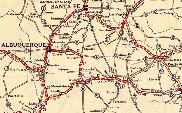
Route 66 Alignment near Isleta
With maps and full information of the alignments of Rte. 66.
- Albuquerque to Lupton (next)
- Santa Rosa to Albuquerque 1937-85 and Santa Fe Loop 1926-37 (parallel alignments)
- Tucumcari to Santa Rosa (previous)
Isleta, New Mexico: Attractions & Sights
Isleta its Attractions
We will begin our journey in Albuquerque and head south along 4th St, the alignment of the 1926-37 Route 66. Albuquerque is such a large city and has so many Route 66 landmarks, that we have dedicated six pages to describe them:
Index to our six pages on Albuquerque & Route 66
- Albuquerque (this page: an overview)
- Eastern Albuquerque
- Nob Hill
- Downtown
- Old Town & Western Albuquerque
- 4th St. Route 66 - 1926-37 Sights
We will start this leg of our Route 66 road trip at the Southern tip of 4th St. Route 66 - 1926-37 as it approaches the Rio Grande, in Barelas, on 4th Street, where it turns onto Bridge Blvd. to cross the Rio Grande; here is the Barelas bridge.
Barelas Bridge
There had been a ford here that linked Armijo on the western side of the river with Barelas and Albuquerque. The first steel bridge was a Pratt Through Truss steel bridge built in 1909, pictured below on the left side of the image. In the 1920s a new bridge replaced it (right side of the image below). At first it carried mostly wagons and sheep. In the early 1900s cars began to use it.
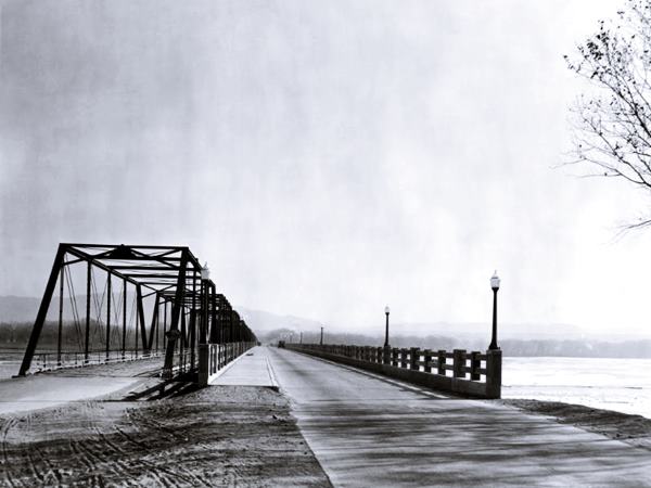
The 1920s brige was replaced by the current one in 1983. On the west side of the Rio Grande is Armijo:
Armijo
This is a neighborhood of Albuquerque with approx. 3,000 residents and it is located on former Route 66 and the original alignment of U.S. 85. It sprung up on the west bank of the Rio Grande close to Barelas Bridge, by the old ford of the Camino Real.
Settled in 1693 by José de Armijo, a native of Zacatecas, several years before Albuquerque was founded. The surname combines the Spanish words "arma" (weapon) and the suffix "-ijo", a diminutive; so it means: "small weapon." The post office opened in 1883, and finally closed in 1936.
The spot by the bridge is knwon as Five Points because Five Points Rd., Bridge St. and Sunset Rd. converge.
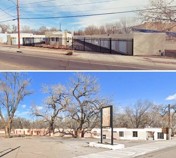
The 1931 Sanborn map shows several motels on the western side of the bridge here in Armijo. Below are two views of two motels near the bridge, click on the links for a St. view:
Southwards towards Isleta
Pajarito and Hubbell House
The highway runs through a suburban area. In the days of Route 66, this was open country, with farms under irrigation close to the river. Suburbia has overtaken the fields. Ahead you enter Pajarito. The word is Spanish and means "little bird", perhaps due to the birds in the cottonwood trees by the river.
To your right after is the historic Hubbell House (left) built in 1825 and enlarged in the 1850s. There is a historic marker by the highway with the story of the site on one side, and a biography of Juliana Gutierrez y Chaves Hubbell (1833-1839) who lived here.
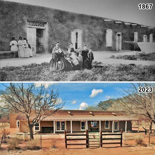
Just ahead is another marker with the story of Pajarito, that reads:
Pajarito
This community is part of the Pajarito Land Grant, which can be traced to 1746 when Spain controlled present-day New Mexico. Covering 47,000 acres between the Rio Grande and Rio Puerco, it is one of the 69 New Mexico land grants confirmed by the U.S. government of the 272 that were claimed. The Gutiérrez family owned, farmed and ranched it. Juliana Gutiérrez, a descendant of the family, married James L Hubbell, a successful merchant. Their home on the Camino Real was the local trading post, stagecoach stop, and post office. Today it is a historical and cultural center.
Olguin's Store
The highway runs south towards Isleta. Much of the old agricultural area that surrounds Isleta has been lost (the land that was non-reservation was urbanized and developed into commercial buildings) NM 47 (the former Route 66 alignment from Isleta south to Los Lunas) is an example of this development.
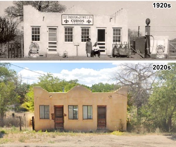
The 1926-31 alignment turns east (left) on the north side of Isleta along NM-147 and after crossing the railroad tracks, to your right is an old former store that sold Indian crafts and jewelry. It was owned by Patricio Olguin who opened it to cater to tourists on Route 66 in the 1920s; the sign above the store that reads: "Hand Made Indian Jewelry and Curios P. R. Olguin." The building is still standing as you can see in the image below:
Isleta Pueblo
Listed in the National Register of Historic Places - U.S. Historic district - N.M. State Register of Cultural Properties
The original appearance of the pueblo can be seen in this postcard below, and the pueblo is a Historic Landmark:
Isleta, New Mexico
As mentioned further up (Isleta's history) this ancient native pueblo, with the mission established in 1622 and the church originally built in 1629 -razed in 1680- and rebuilt in 1712.
Pueblo Of Isleta, New Mexico, Native American Fred Harvey Postcard c.1920s
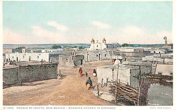
Its name Isleta (Little Island) came from the fact that when the Rio Grande is in flood, one branch surrounded it; the pueblo was not flooded because it stands on a mound.
Important rules of etiquette during your visit to a Pueblo
Enjoy your visit with respect: Pueblos are on tribal lands and the local customs, religion and traditions must be respected.
- Check that access is allowed (leaders may restrict access for private ceremonies) and be prepared to pay an access fee
- Photography. Taking photos may be totally prohibited or a permit may be required. Check with the Tribal Office. Even if you have a permit, always request permission before taking a photo of a tribal member. Leave your cell phone out of sight and silence it, as it could be confiscated
- Don't litter. Don't carry or use alcohol or drugs
- "Off Limits" signs must be respected. Don't remove artifacts or pottery shards
- Don't speed. Respect traffic signs
- Lock your vehicle, the Pueblo isn't responsible for your lost belongings
- Respect the local people. Dances are not a show, they are a ceremony. Show respect and remain silent at all ceremonies
- Cemeteries, Kivas, ceremonial rooms are sacred places and entry is not allowed for non-Pueblo people
San Agustín de la Isleta Mission
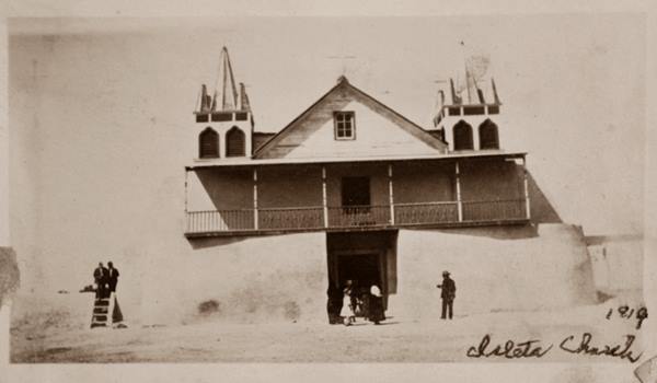
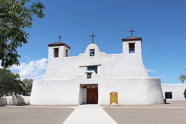
The mission church is a Franciscan church built by Juan de Salas in 1639, rebuilt in 1712 and later modified in the 1900s to adapt it to contemporary church design -eliminating its former flat roof.
It is the second oldest church built in the U.S. and is still used for religious services, it is second only to the San Miguel Church in Santa Fe, built between 1610 and 1626, and rebuilt in 1710.
The old mission church looked south on a wide plaza. In 1919, it had som fancy boxes as bell towers and a pitched roof. It was restored in 1959, removing the fairy-tale belfries and the gabled roof.
Current appearance of San Agustín de la Isleta Mission in Isleta, NM
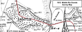
1912 Rio Grande Survey map with Isleta and the highway (red line)
Click on image to enlarge.
Source
As you can see in the image map (click on it to enlarge it), in 1912, the highway from Albuquerque entered the pueblo and curved round the church and ran through plaza to head east to the state-built bridge across the Rio Grande that was constructed in 1912. This brought more traffic to the community and it caused accidents. By 1923 it was moved north, and in 1926 carried U.S. 66 around the central part of the Pueblo.
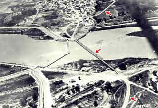
1937 aerial view of the Rio Grande, the bridge and Isleta.
Click on image to enlarge.
Source
The 1912 bridge was a Pratt Through Truss structure replaced by the current one in 1961. It can be seen in the aerial photograph that looks west taken in 1937, the red arrows mark the course of the old highway and the bridge. But, US 66 had been realigned along the western side of the pueblo all the way to Los Lunas in 1931, and avoided having to cross the river here.
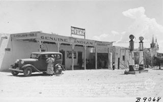
1938 El Pueblo Store Isleta.
Click on image to enlarge.
Source
There was a gas station with two pumps, and a Trading post on the western side of the church, it had been the original home of the Isleta Indians First Governor, and in 1938 when Burton Frasher took the photograph, it was the El Pueblo Store, owned and ran by Julia Culver, his Great Granddaughter. The church is on the right side of the picture (with its fairy-tale steeples).
End of this leg of your Road Trip
This ends this leg or your Route 66 road trip in Isleta. Now you can cross the Rio Grande and visit Peralta driving the 1926-31 US 66 alignment on your way to Los Lunas or head straight to Peralta along the 1931-37 US66.

Sponsored Content

>> Book your Hotel in Albuquerque

Credits
Banner image: Hackberry General Store, Hackberry, California by Perla Eichenblat
Robert Julyan. 1996, The Place Names of New Mexico, UNM Press.

