Route 66 in Peralta NM
Index to this page
About Peralta, New Mexico
Facts, Trivia and useful information
Elevation: 4,859 ft (1,481 m). Population: 3,4762 (2025).
Time zone: Mountain (MST): UTC minus 7 hours. Summer (DST) MDT (UTC-6).
Peralta is the a town in Bernalillo County, NM on the Rio Grande.
History
People have been living in this region for more than 10,000 years. During the 1300s, the Tiwa people, farmers, settled in the valley of the Rio Grande and grew their crops irrigating them with the river's water.
The Spaniards reached the area in their search for more "Cities of Gold" in 1540: Francisco Vásquez de Coronado was the first European in the area. He named the natives "Pueblo", after the Spanish word for "village".
It took half a century for the Spanish to settle the area. They founded Santa Fe in the early 1600s and began the conversion of the Pueblo people to Catholicism. The natives were opressed and exploited by the conquerors "encomienda" system, a mix of serfdom and forced-labor, and they rose in rebellion in 1680, razing the towns and pueblos. The Spanish fled but returned in 1692 and defeated the natives.
The colonial system was re-established. Albuquerque was founded in 1706 as a key stopover on the Camino Real (Royal Road) that ran south into Mexico, from Santa Fe It passed by what today is Peralta.
Origin of the name Peralta
Peralta is a Spanish surname, and was the name of Pedro de Peralta, governor of the territory who founded Santa Fe in 1610. It derives from the Latin "petra alta" or "high stone - high cliff".
Diego de Padilla, who lived in Albuquerque requested a grant of land in 1718 claiming that it had belonged to an ancestor before the Pueblo Revolt. The Governor approved the grant and he was assigned 52,000 acres of land. His sons sold the land to Isleta Pueblo. Further south was the ranch of the Chaves family, called Los Pinos. In 1837, Juan Otero who was a descendant of the Oteros who owned land south of modern Peralta, married Mercedes Chaves and they moved to where Peralta is now located, settling there on a large hacienda.
In the meantime Mexico won its independence from Spain in 1821, it retained the region of New Mexico but had to cede it to the U.S. after its defeat in the Mexican - American War (1846-48). For the brief period of 1848–1852, Peralta was the seat of Valencia County.
It was the site of the American Civil War skirmish known as the "Battle of Peralta" during the campaign of Confederate General Henry Hopkins Sibley in 1862.
There is a marker commemorating the event (St. view), on the south side of the church.
Route 66 was aligned through the town in 1926, but in 1931 the highway moved out, to the western bank of the Rio Grande, bypassing Peralta. The town incorporated in 2007.
Accommodation in Peralta
There is lodging along Route 66 in Peralta and nearby in Albuquerque:
> > Book your Hotel in a Albuquerque, Isleta or Los Lunas
More Lodging close to Peralta on US 66
Below you will find a list of some of the towns along Route 66 in New Mexico. Click on any of the links to find your hotel, motel or accommodation in these towns (listed from east to west):
On Route 66's Main alignment
The Santa Fe Route 66 segment
Eastwards
Westwards
>> There are RV campgrounds near Peralta in Albuquerque.
The weather in Peralta

Peralta on Route 66
Peralta has a sunny (278 sunny days per year) and very dry (very low relative humidity) climate.
The high elevation and the dry air provoke large swings between day and night temperatures, even in summer.
Peralta's average High ⁄ Low Temperatures during summer (Jul.) are: 92 ⁄ and 65 °F (33 ⁄ 18 °C). The average during winter (Jan) are: 47 ⁄ and 24 °F (8 ⁄ -4 °C)
Summers are hot and winters are relatively cold. Rainfall tends to fall during the summer monsoon season (July through September), and adds up to about 11 in. per year (279 mm). Shielded by mountains to the east, snowfall is quite low: about 10 inches (25 cm) per year.
Tornado risk
The tornado risk in Peralta is nil: Valencia County has no Tornado watches.
Tornado Risk: read more about Tornado Risk along Route 66.
Map of Route 66 in Peralta, NM
Read the Detailed Description of this segment (Albuquerque to Lupton). Below is the interactive map:
>> Custom map of Route 66 in Peralta

1916 N.O.T. Road map, Peralta
Click on image to enlarge.
Source
Check out our interactive custom map: the orange line shows Route 66's 1926-31 alignment across Peralta. The red line south of Isleta is the 1931-37 realignment along the west side of the Rio Grande from Isleta to Los Lunas, bypassing Peralta.
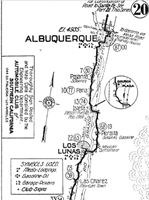
The original Route 66 was aligned through Peralta in 1926 along three previous highways, the "Ozark Trail", the "Santa Fe Trail" and the "National Old Trails". See the 1916 National Old Trails (N.O.T.) map from Albuquerque to Los Lunas (click to enlarge it). Peralta had supplies and gasoline.
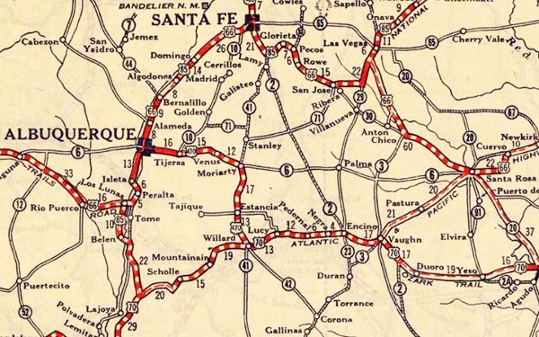
These highways were known as "Auto Trails" and part of a public demand for "better roads": a movement that lobbied for good highways that could be used by motor vehicles, and also signs to mark them and help drivers to find their destination. New Mexico authorities improved the original Ozark Trail in 1914 and designated it as New Mexico State Highway 3. The thumbnail map (Click to see large size map), shows some of the "Auto Trails" that could be used by cars in 1912 in the area near Peralta (located between Isleta and Los Lunas on the map's lower middle right side); the trails are marked with red lines.

1912 Road map, western NM
Click on image to enlarge.
Source

1925 Road map, western NM
Click on image to enlarge.
Source
The second thumbnail map above from 1925 (click on it to see the full sized map) shows the roads that existed one year before Route 66 was created.
Those marked "22" (National Old Trails Rd., coming from Los Angeles) and "32" (New Santa Fe Rd.) with white letters in a black box, went from Gallup to Albuquerque and through Santa Fe. Highway "50" was the Ozark Trails.
The only paved sections (full black line) were between Isleta to Albuquerque and north to Bernalillo, and Albuquerque and Tijeras. The highway from Bernalillo to Santa Fe, and beyond Isleta was "improved" (dashed line), the rest were either graded or dirt roads. Peralta appears on an improved segment of Route 66 on the lower right side of the map.
Route 66's original alignment
At Isleta, the 1926 alignment of US66 crossed the river to its eastern side and went south, going through Peralta. South of this point it crossed the Rio Grande again into Los Lunas.
From here it headed west and ran close to the Atchison Topeka and Santa Fe railroad tracks climbing out of the Rio Grande Valley, curving towards Suwanee.
1931 realignment
See the red line in our custom map.
US 66 was paved by 1928 and it was realigned along the west bank of the Rio Grande in 1931 to shorten its course and remove the two additional crossings of the Rio Grande river south of Albuquerque's Barelas Bridge. This realignment bypassed Peralta (what now is NM-47 used to be US66).
1937 Laguna Cut Off
The new bridge across the Rio Grande in Albuquerque just west of Old Town was completed in 1931 and funding was secured for a bridge across the Rio Puerco further west of ABQ, which was built by 1933 paved the way to another realignment.
Cut Off
The "Laguna Cut-Off" is named after the Laguna Mission village west of ABQ and Los Lunas. In 1937 the whole highway was moved north. It used the new bridges across the Grande and Puerco rivers and climbed out of Albuquerque westwards with a straight course towards Suwanee, Mesita and Laguna. Both Isleta and Los Lunas had been cutoff for good.
Peralta is on the middle left side:

Route 66 Alignment near Peralta
With maps and full information of the alignments of Rte. 66.
- Albuquerque to Lupton (next)
- Santa Rosa to Albuquerque 1937-85 and Santa Fe Loop 1926-37 (parallel alignments)
- Tucumcari to Santa Rosa (previous)
The Santa Fe Loop (1926 - 1937)
Our Santa Fe Loop page describes the complete 1926 to 1937 alignment of Route 66 from Santa Rosa to Albuquerque through Pecos, Santa Fe and Peralta.
Peralta, New Mexico: Attractions & Sights
Peralta its Attractions
Drive into Peralta from the north, heading across the Rio Grande from neighboring Isleta along NM-47. This was the original alignment of Route 66.
Peralta was on Route 66 for only five years, from 1926 to 1931. After that date and until 1937 US 66 ran on the other side of the Rio Grande, from Isleta to Los Lunas.
Most of the agricultural area around Peralta, Isleta Pueblo and Los Lunas has been lost because the "non-reservation" area was developed and urbanized. Farms were replaced by malls and commercial buildings.
Our Lady of Guadalupe Church
Listed in the National Register of Historic Places
To your right, at 3674 Hwy 47, Peralta
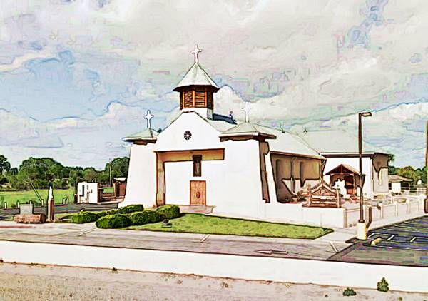
The parish church of Nuestra Señora de Guadalupe (Our Lady of Guadalupe) is young by the Rio Grande Valley standards because it is shy of 140 years old as it was built in 1879.
It is a historic site like the Sangre de Cristo church in neighboring Valencia.
Historic Our Lady of Guadalupe church in Peralta, NM

On the south side of the church, just 100 yards away was the First Baptist Mission in the area, an adobe building with a flat roof and a verandah built in 1854. It witnessed the Battle here between Union and Confederate forces that took place in 1862 when Confederate soldiers occupied the hacienda at Los Pinos (The Pines), it was in those days owned by Henry Connelly who had married the widow of Jose Mariano Chavez, its previous owner. Connelly was a successful businessman and had been appointed Territorial Governor of New Mexico by President Abraham Lincoln. The soldiers stood their ground here after their defeat in the Battle of Glorieta Pass. On April 15, 1862 the place suffered canon bombardment and the Confederate forces escaped across the Rio Grande to Los Lunas. The skirmish left seven soldiers dead and Connelly's hacienda in ruins.
End of this leg of your Road Trip
The highway heads south into Valencia, now part of Los Lunas before crossing the Rio Grande into Los Lunas.
Sponsored Content

>> Book your Hotel in Albuquerque

Credits
Banner image: Hackberry General Store, Hackberry, California by Perla Eichenblat
Robert Julyan. 1996, The Place Names of New Mexico, UNM Press.

