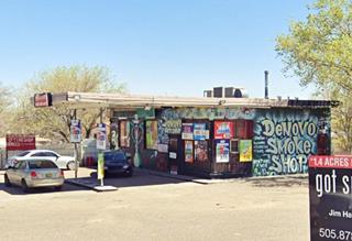
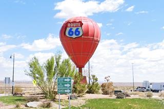
Route 66 in Old Town and Western Albuquerque NM
Albuquerque's Attractions along US 66
A List of Stops and Landmarks
We will use the ❌ symbol to mark those that have been torn down.
1. Eastern Albuquerque
- Paradise Club ❌
- Little Beaver Town ❌
- Original 1930s Roadbed
- Holiday Inn East
- Bar-B-Q Inn
- Phillips 66 Gull Wing service station
- Tropicana Lodge, later Nendel's ❌
- Caravan Nightclub neon sign
- Iceberg Cafe in East ABQ ❌
- Rodeo Court ❌
- Steer on a pole
- Eldorado Court later Roma Motel ❌
- Zuni Motor Lodge ❌
- Muffler Man
- Fair Grounds Motel ❌
- Carrico Modern Court ❌
- Sundowner Motel & Bill Gates
- Former Denny's Diner
- Leonard's ❌
- Tracy's Modern Court ❌
- Trade Winds ❌ / Replica Neon Sign
- Honey Dew Drive Inn ❌
- Nod-A-While Motor Lodge / Silver Spur ❌
- American Car Wash
- Cooksey Court, later New Mexico Motel ❌
- Bimbo's Drive In ❌
- Anchor Inn / Bar-X Motel& ❌
- New Chinatown Restaurant neon sign
- Ambassador Lodge ❌
- Coronado Court ❌
- El Sombrero ❌
- American Motor Inn
- La Puerta Motor Lodge
- Luna Lodge
- Piñon Motel
- Lo-La-Mi Lodge ❌
- Bow & Arrow Lodge
- Chevron Gas Station
- Phillips 66 Gull Wing Gas Station
- Loma Verde Motel
- Pioneer Motel
- Texaco Station
- Ace Cafe
- Tewa Lodge
- La Vela Lodge
- Desert Sands Motel Neon Sign
- Hiland Theater
- Zia Motor Lodge
2. Nob Hill
- De Anza Motor Lodge
- Circle K Motor Court
- Bel Air Motel
- Goody's Restaurant
- Martens Tourist Court and Trailer Park ❌
- Comfort Lodge
- Town House Restaurant
- Aztec Court ❌
- Two Gas stations, one gone, Mobil survived
- One of the First KFC in ABQ
- Kurt's Camera Corral ❌
- Original Iceberg cafe ❌
- Rainbow Cafe
- Hiway House Motel
- Pipp's Texaco
- Triangle Cafe ❌
- Tonnie Pegue's Standard Oil Service Station ❌
- Lobo Joe's ❌
- El Oriente Auto Court
- Premiere Motel
- TraveLodge Motel
- The Toddle House
- Nob Hill Motel
- Nob Hill Conoco
- Johnson Standard Station
- Nob Hill Business Center
- Jones Motor Company & Texaco
- Valentine Diner Police Substation
3. Downtown
- Pig and Calf
- 66 Diner
- A Phillips Petroleum Gull Wing
- Cottage Bakery
- Zia Oil Station
- Park Lane Hotel ❌
- Lorlodge Motel
- Central Ave. Underpass
- Hiway House #1 ❌
- Railway Depot
- Glorieta Sation Neon Park
- Yrissari Building: Maisel's first store
- Franciscan Hotel ❌
- Sears
- Hospital
- Little House Cafe ❌
- Crossroads Motel
- Hyatt Chalet Motel
- Whole Hog Cafe
- Imperial 400 Motel
- TraveLodge Downtown
- Hilton Hotel
- El Fidel Hotel
- Kimo Theater
- Lindy's Coffee Shop
- Maisel's Indian Trading Post
- Holocaust & Intolerance Museum of New Mexico
- El Rey Theater
- Firestone Tires
- Downtowner Motor Inn
- Skinner Grocery
4. Old Town & Western Albuquerque (This Page)
- Chevron ❌
- Lorlodge West
- Bell Indian Trading Post
- World Court ❌
- Desert Inn ❌
- Arrowhead Lodge ❌
- Texas Ann Court ❌
- Moon Motel and Café ❌
- White Way Court ❌
- Katson's Drive Inn ❌
- Country Club Court ❌
- Pueblo Bonito Court ❌
- Casa Grande Complex ❌
- Tingley Beach and Beach Motel ❌
- Rio Grande Bridge
- The Volcanoes
- El Nido Motel ❌
- Rainbow Court
- Sandia Motel ❌
- Duke's Court ❌
- Stop In Court ❌
- Auto-Tel Court ❌
- Miller's Court ❌
- Silver King's Auto Court ❌
- Blue Bell Court ❌
- Hill Top Court ❌
- Arrow Court and Hill Cafe ❌
- Navajo Court
- Dutch Motel ❌
- California Court ❌
- Hill Crest Motel ❌
- Sky Court ❌
- Mile Hi complex
- Covered Wagon Court
- Hubbell Motel ❌
- Oasis Lodge ❌
- Phillips 66 Gull Wing ❌
- Jerry Unser ❌
- Route 66 Conoco
- Route 66 Travel Center
- Capri Motor Hotel
- Horn Oil Co. Motor Lodge
- Sandia Theatre
- Old Town of Albuquerque
- San Felipe de Neri Church
- Tower Court
- El Don Motel
- Monterey Motel
- Country Club Court
- El Vado Auto Court Motel
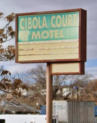
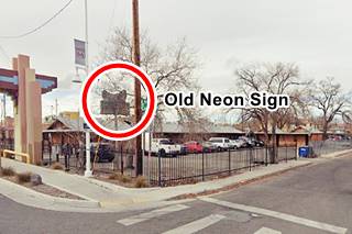
- Relict Motel Signs: Cibola and Super 6
- El Campo Tourist Court
- La Hacienda Camp
- Siesta Court
- Americana
- Western View Diner and Steak
- Adobe Manor
- Westward Ho Motel
- French Quarter Motel
- Grandview Motel
5. Fourth St. Route 66
- Cavalier Court ❌
- Crossroads of Route 66
- Ruffin's Texaco #1
- Horn Oil North 4th St.
- Ruffin's Texaco #2 ❌
- El Camino Motor Hotel
- King's Rest Court ❌
- Court John ❌
- Madonna of the Trail
- Monkbridge Manor ❌
- Luke Apartments
- Clyde Miller Tire & Service Station
- Texaco Gas Station
- Scott's New Motel ❌
- Barelas-South Fourth Street Historic District
- Hudson Auto Sales
- B. Rupee Drugs
- Tasty Freeze Drive In
- Durand Motor Company
- Hi-Way Service Station - Horn Oil
- Sinclair Service Station
- Magnolia Service Station
- Navajo Super Service Station
- Red Ball Cafe
- Fito's Cafe

Old Spanish Town and Western Albuquerque attractions
Along Route 66 into the Old Town ABQ
In this page we describe the classic Route 66 sights from east to west, starting at the intersection of 8th Street and Central Avenue on the 800 block, leaving the Downtown to head into the original settlement of Albuquerque, cross it, head across the Rio Grande and climb the Nine-Mile Hill through western Albuquerque...
We will use the ❌ symbol to mark those that have been torn down.
Chevron ❌
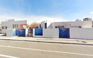
To your right at 8th, is Robinson Park, which has been there since Route 66 was aligned along Central. To your left, on the triangle formed by the eastbound lanes of Central and Park Ave. there was a Chevron Filling Station according to the 1942 Sanborn Insurance map (802-810 Central SW). The picture looks towards the northwest from Park that runs in the foreground. Notice the Cafe beyond the gas station (900 Central SW) also gone. See the view of this same spot nowadays.
Desert Inn ❌
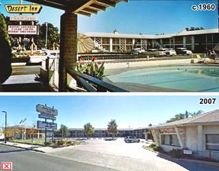
Adjacent to the Chevron, at 918 Central, this motel was built in the 1950s and torn down recently. It's owners were Clyde and Goldie Tyler. It had "Sixty-one Deluxe units" and a pool. The image shows its postcard from around 1960 and a last view before it was razed in 2011.
Ahead, to your right, on the NE corner with 10th St. (1001 Central NW) was another Filling Station (1942 map); later it became the Cafe Oaxaca and has been torn down.
Sleepy Hollow Court
The 1942 insurance map shows Tourist Cabins with twelve units in a U-shaped layout on the rear side of the property, with a corner office on Central and 11th (1021 Central NW). Later under the management of Mr. and Mrs. Louis T. Higgins, it grew to 22 units. Now it is an apartment complex that has kept the original layout.

Sleepy Hollow Court 1950s. Source. Click image to enlarge
Lorlodge West
Across, to your left at 1020 Central SW is a motel built in the 1960s, now an apartment complex (Millennium Flats), is the former Lorlodge West; there was another Lorlodge on the eastern side, by the freeway, on Central: Lorlodge Motel East; it had "Pool - Phones - TV Refrigerated Air - Central Heat Free coffee in Room."

Lorlodge Motel 1960s. Source. Click image to enlarge
Across from the Lorlodge, on the triangle to your right, at Central, 12th and Kent (1110) there was another classic gas station that has been there since the 1940s and the building is still there, though slightly altered as a hair stylist shop. (map and St. view.)
Capri Motor Hotel
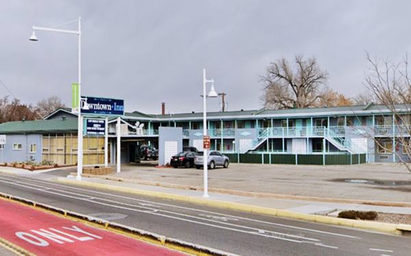
On the NW corner of Central and 12th St. at 1213 Central Ave NW, this motel dates back to the late 1950s when it was the Capri Motor Hotel. In the 1970s it was the Limelite. Now it is the Downtown Inn.
Capri City Center Motor Hotel in a vintage 1950s postcard
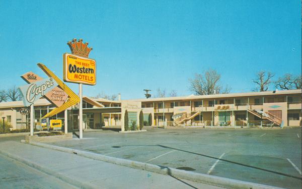
Albuquerque, NM. Source
Now it is almost unchanged, but it is a pity it lost its lovely 60's Googie style neon sign:
The Capri City Center Motor Hotel - now Downtown Inn as it looks today
Old Filling Station

Old 1940s gas station. St. view. Click image to enlarge
Adjacent to the Capri, on the NE corner with 13th (1221). is a former gas station. With a low long building and an angled office and a short canopy. Still standing. It appears in the 1942 Map.
Bell Indian Trading Post
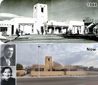
The next stop is Bell Indian Trading Post Co. at 1503 Central NW, to your right. Jack Michelson opened his Native American Indian jewelry trading post in Albuquerque in 1932. He ran it with his wife Mildred, whose maiden name, Bell was chosen for the business. Both appear in the picture with the "Then and Now" views of their store. In 1935, they merged with their main competitor, Maisel. (Read about Maisel's Indian Trading Post in the Downtown district). During WWII they made insignias for the Army and after the war, in 1948, they opened their "Million Dollar Investment" a Pueblo style building that is still standing on Central (1).
Horn Oil Co. and Motor Lodge

1946 view of Horn Oil gas station. Source. Click image to enlarge
Listed in the National and State Register of Historic Places
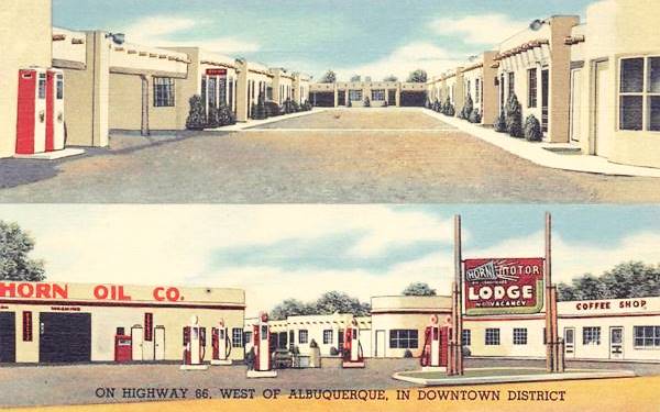
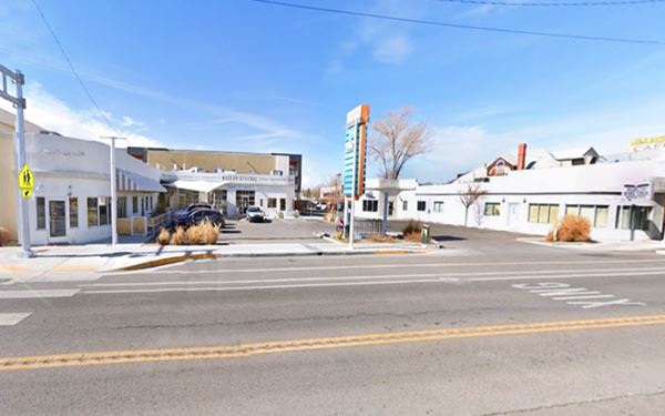
Drive west to the next stop at 1720 Central Ave SW. The Historic Horn Oil Co. and Motor Lodge was built in 1946. Calvin Horn (1918-1996) and his brother H.B., founded Horn Oil Co. in 1939 and built it up to a business with 26 gas stations and this motel in Albuquerque.
The 1942 Sanborn map shows two parallel sets of units perpendicular to Route 66. In the front there was a filling station on the eastern side and a restaurant on the western side. The spot has been redeveloped by Jay Rembe, and the motel was modified, but the gas station and cafe are intact. Now it is the "Country Club Plaza". Below are some "Then and Now" views Notice the symmetry in the left and right wings (gas station store and cafe).
The postcard reads "Beautyrest Mattresses... Complete Automotive Service Correspondence Carefully Handled until your Arrival..."
Horn Motor Lodge
The former Horn Oil Co. and Motor Lodge as it looks today:
World Court ❌
Across from Horn's motel, at 1729 Central, where the Manzano Day School is now located, was the site of the the World Court. It had "30 Modern Cabins - Innerspring Mattresses. RATES $1 and UP. O. K. Campbell, Mgr." Later as the numbers changed along Central, its postcard placed it at 1717 N.W Central: "Located in the Heart of Albuquerque." Originally it had a Standard Station, Hoefgen and Branson's in the 1930s, and later it was a Sinclair station and a Conoco. The station's building had a tower topping its office and a "W" at its tip. It survived into the 1990s. Below are some pictures, click on them to enlarge them.

World Court (gone) c.1930s. Source
Click to enlarge

World Court (gone) c.1940s. Source
Click to enlarge
Sandia Theatre
Just west of the old Horn complex, to your left, at 1816 Central Ave SW. Built in 1946 with 746 seats, it was acquired by Albuquerque Exhibitors Inc in 1952; they also owned the El Rey Theater, and used them to host Spanish language films. It closed in 1956 when the TV usage grew and demographic shifts moved the viewers into new neighborhoods.
There was a filling station (1815) across Central from the theater and a Restaurant on the corner of Rancho Seco (both gone).
Will Rogers Highway Court
The 1942 Sanborn map shows a "Tourist Cabins" with a U-shaped layout and 20 units at 1842 West Central. It was the Will Rogers Highway Court, mentioned in 1946 by Rittenhouse andtorn down in the early 1970s.
Historic Old Spanish Colonial Town
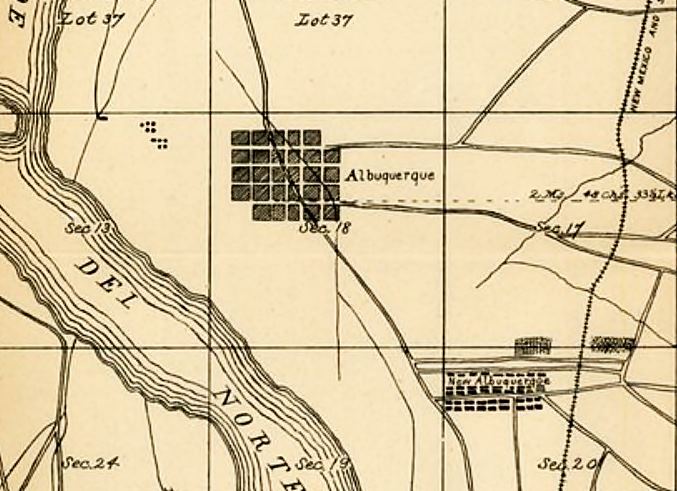
1883 plat of Albuquerque. Source
Click map to enlarge
Listed in the National and State Register of Historic Places
Here where Las Lomas Blvd. meets Route 66 you are just 200 yards away from the center of the the old Colonial Town, there is a public parking space by San Felipe and Central. Park and take a short walk to visit the the historic Plaza.
The Old Town of Albuquerque is the original site where the Spaniards founded the town in 1706.
The Governor of New Mexico, Francisco Cuervo y Valdés based in Santa Fe decided that another settlement was necessary along the Camino Real. He chose a spot close to the Sandia Mountains known as Bosque Grande de San Francisco Xavier (St. Francis Xavier's Large Forest) it had pastures, timber and was close to the river to provide water for irrigation. The town was named Villa Real de San Francisco Javier de Alburquerque (notice the "R" in Alburquerque, which was the correct way to spell the surname of the Viceroy of Mexico after which it was named). In 1776 it was renamed Villa de San Felipe Neri de Alburquerque. The extra "R" was dropped when it became part of the U.S. Territory following the war with Mexico in 1848.
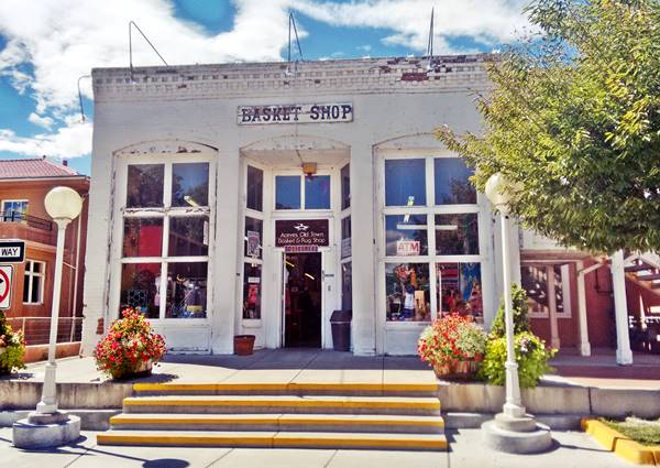
Town layout
The town followed Spanish Colonial platting rules that can be found across the Americas (Mexico City, 1520. Lima, Peru, 1535. Buenos Aires, Argentina, 1580). It consists of a central rectangular public sqare, the Old Plaza, which was the heart of the Spanish colonial town. The main church, often a Cathedral located off-center on one of the sides of the Plaza, and the main government buildings such as Customs House, the Cabildo or municipal council. The wealthy people lived close to the Plaza. The town consisted of a grid of square blocks 100 varas (rods) long approximately 100 yards. With narrow streets 30 feet wide.
The old map (click on it to enlarge it) shows the Rio Grande to the west (left), the old town roughly 5 blocks wide by 5 blocks long, on the upper left, the Camino Real running north to south and, on the lower right side, the New Albuquerque by the railroad (the trakcs run top to bottom to the right).
Historic Old Town Plaza
At the Plaza you will see the San Felipe de Neri historic church built in 1793 is located on its northern side.
This part of the city still looks like it did in the 1700s, with Pueblo-Spanish styled adobe buildings that have been converted into souvenir shops and restaurants. Enjoy its brick paths, hidden patios and adobe benches ("bancos").
On the east side of the Plaza is the Portal Market an open air venue where the local artisans sell their handmade authentic Southwest jewelry.
More information at the www.albuquerqueoldtown.com. You can by some souvenirs or enjoy the scene and return to your car and continue your Road Trip.
San Felipe de Neri Church
Listed in the National Register of Historic Places
2005 N Plaza St NW, Albuquerque, NM.
Built in 1793, it is one of the oldest surviving buildings in the city. It replaced the original 1706 mission church, completed in 1719, whose original name was San Francisco Xavier, but the Duke of Albuquerque renamed it after King Phillip of Spain ("Felipe").
Below is the photograph I took in Sept. 2016:
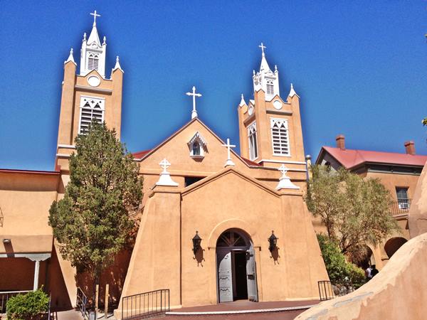
The original building collapsed in 1792 due to heavy rain and the current church was erected the following year. Towers were built in 1861 and the school and convent were added between 1878 and 1881.
Indian Pueblo Cultural Center

Indian dancers at Indian Pueblo Cultural Center. Credits
2401 12th St. N.W. Albuquerque. This Map shows where it is located.
Discover the Pueblo Indian culture. See the traditional native dances, buy handicrafts and turquoise jewels at the arts store, visit the museum and taste the local food at the café.
More information at the official website: www.indianpueblo.org and (505) 843-7270
From the Old town to the Rio Grande along Route 66
Westwards along Route 66

Shamrock Station
The Nov. 1939 issue of the Albuquerque Progress magazine showed a Shamrock gas station at 1924 West Central managed by E.C. London. The building has survived relatively unscathed! Below is a "Then and Now" set of photos. Click to enlarge:

Shamrock Station in 1939. Source. Click to enlarge
Arrowhead Lodge ❌
Across San Pasquale on its SW corner at 2000 Central, where the a manor-like building is now located there was a filling station in the 1940s and, next to it where the Post Office is, at 2016 Central, was the Arrowhead Lodge which at one time was also known as the Wigwam Court with a wigwam in its courtyard. By 1980 it had been razed.
Wigwam Court (gone) c.1940s. Source
Click to enlarge

Arrowhead Lodge (gone) c.1940s. Source
Click to enlarge
Opposite, on the NE corner with San Felipe is a former Filling Station shown in the 1942 map it originally consisted of a building on the right side of the property, later expanded in the 1950s with service bays to the right. Still standing but repurposed as a shop.
Ahead, between Romero and Rio Grande Blvd, to your right (2025) there was another gas station, long gone.
Tower Court
Listed in the National and State Register of Historic Places
2210 Central Ave SW, Albuquerque, to your left after Clayton St. The Tower Court motel was built in 1946, and mentioned in Rittenhouse's Guidbook to Route 66 that same year. It was owned and ran by Al and Elnora Pizzoli; its postcard proclaimed "Modern - In - Every - Detail." Now it is a private apartment complex. It has lost its emblematic "Tower" but retains its original layout and appearance as you can see in the images below (click to enlarge):

Tower Court motel vintage postcard. Albuquerque NM. Source
Click to enlarge
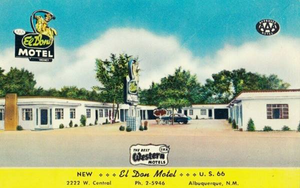
El Don Motel
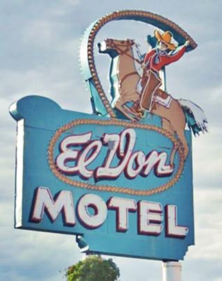
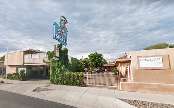
Also to your left, adjacent to Tower court, at 2220 Central Ave SW, Albuquerque is another classic motel with a great neon sign (pictured).
The fifteen-unit El Don Motel proclaimed on its postcard: "Tubs and Showers. Tiled Baths. Free Radios. Air Conditioned. Wall-O-Matic Heat - Restaurants near. Just 3 blocks to the Historic Old Albuquerque Palaza. Less than 5 minutes to Heart of City. AAA Approved. Member of the Best Western Motels." at that time it was ran by Mr. and Mrs. Dan W. Eitzen.
The Spanish word "Don" placed before a man's name shows respect in a conversation, its meaning differs from the Italian Don (the head of a Mafia family), it is simply Esquire; in this case perhaps it refers to the cowboy with the lasso in their neon sign.
It's basic "U-shaped" layout has remained unchanged; it has also kept its iconic Route 66 sign of a neon cowboy riding a horse with a lasso in his hand. But a second floor was added to the eastern wing.
The El Don Motel as it looks nowadays
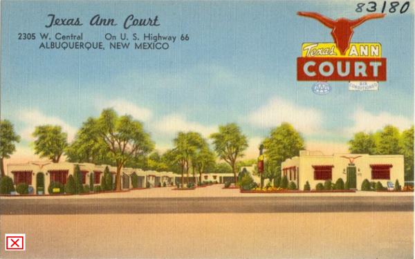
Texas Ann Court ❌
At 2305 W. Central across from El Don, where the McDonald's is now located. Its postcard announced "At the Sign of the Longhorn". This motel was ran by the parents of Vivian Roberta Jones (1909-1979) better known under her artistic name of Vivian Vance, a co-star in the 1950s series "I Love Lucy" as Ethel Mertz. Vance lived in ABQ and began her career here!

I Love Lucy cast. Source
Vivian Vance lived in Albuquerque and got her start at the Albuquerque Little Theatre.
The episode 16 of season 4 aired on Jan. 31, 1955 and filmed the day before Thanksgiving on Nov. 25, 1954 shows Lucy and Ethel and their husbands spend the night in a motel in Amarillo Texas before arriving in Ethel's hometown, Albuquerque. The Amarillo motel is actually the Albuquerque Texas Ann Motel (2). The image shows Vance (left) and Lucille Ball (right) above are: William Frawley (Fred Mertz), Desi Arnaz (Ricky Ricardo) Vance's and Ball's husbands in the TV show.

Moon motel vintage postcard. Albuquerque NM. SourceClick to enlarge
Moon Motel and Café ❌
Moon Cafe proclaimed in its postcards that "We Never Close... Dinner and short orders 24 hours a day.
It was located to your left, just west of El Don at 2316 West Central. The Moon Motel was part of the complex and it offered "A Bit of Everything."
Rittenhouse mentions it in is 1946 Guidebook.
It was torn down in the mid 1960s and apartment building has been built on the property.

Monterey motel vintage postcard. Albuquerque NM. Source. Click to enlarge
Monterey Court

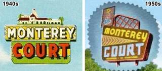
Monterey motel neon sign on Route 66
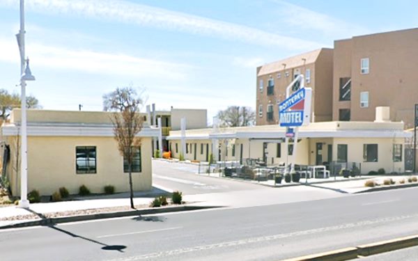
The Monterey is adjacent to the Moon Court, to your left at 2402 Central Ave SW, Albuquerque
At one time it was owned by H.C. Whitfield, and sold Shell products. Its business card with the old numbering system (address was 2332 West Central) mentions its main features: "On Will Rogers Hwy. U.S. 66. As Good As The best Modern --- Complete with Kithcenettes. Adjoining Golf Course and Bathing Beach. 1 Mile West of Business District and Hwy. U.S. 85"
The Monterey Court or Monterey Motel mentioned by Rittenhouse in his guidebook.
Neon Sign
It changed its original 1940s neon sign in the 1950s for the current one. The original sign had the outline of Monterey's mission but the later one adopted a classic 1950s design, with angled shapes and a neon arrow with triangular shape. This sign has been restored and is still standing. It has undergone some minor changes: The word "Court" was replaced with the word "Motel" and the figure on to its upper part, above the "M" of Monterey has been removed as you can see in the image further up, comparing the 1940s and 1950s neon signs.
Monterey Motel in a vintage 1960s postcard
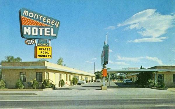
White Way Court ❌
Across from the Monterey, to your right, the Econolodge (2321 Central) replaced a classic motel, the White Way lodge. It had a deep U-shaped layout with trees along the central courtyard and "26 Modern, Comfortable, Shaded... units." The Econolodge was later built over the west wing. Its owners were Mr. and Mrs. J.H. Doake, stated on their postcard "It's Okey Doke to stop with the Doakes".

Arrowhead Lodge (gone) c.1940s. Source
Click to enlarge

Mandril Texaco in 1941. Source
Click to enlarge
Mandril Texaco
The gas station next to it appears in the Albuquerque Progress edition of June 1941> "Chuck Mandril is lesee of the new Texaco Station at 2323 West Central." This original building was replaced by the current one that was placed further away from the highway. It is a Matawan style Texaco built during the 1960s and its features have a slight Ranch style: Two-part flat roof over service area and office (here a faux-tile roofing was placed over the office). Angled roof sides and fixed transoms above the service bays; Inward sloping pent roof (the black ledge around the building above the doors and windows) and a semi-detached canopy with inward-angled fascia. This is its Street View.
Country Club Court ❌
It was located next to Mandril's Texaco, to your right at 2411 Central Ave NW. The Country Club Court dated back to 1937 and it was one of the original motels on the new alignment west of Albuquerque. It too was mentioned by Rittenhouse in 1946, and it got its name from the Country Club and golf course located just south of Central, now known as West Park. The place later became the the Spanish Gate Motel, Prince Motel, and finally the 21 Motel before it was razed in 2019.

Country Club Court c.1960. Source. Click to enlarge

Motel 21 was the Country Club Court (gone). Click for 2017 Street view
Katson's Drive Inn ❌

1940s Katson's Drive In. Source
Click to enlarge
At 2425 West Central was Virgil Robert Katson's restaurant with curb service, coffee shop and dining room. It also had a Curio Shop. It opened on May 18, 1940 and closed in September 1942 the Albuquerque Journal reported that it would close for the duration of the war Katson moved his staff to his dowtown Court Cafe. Karson's had a gift, jewelry and appliance store on 418 W Central and another eatery, Katson's Hickory Restaurant at 111 W Central and the Court Cafe on 4th St.
It was razed in around 1960. It was located on the back of the spot where Los Compadres (earlier Village Inn) is now located (street view) as you can see in this 1955 aerial photo
Pueblo Bonito Court ❌

1940s Pueblo Bonito advertisement. Source
Click to enlarge
Located at 2424 or 2400 W Central , depending on the postcard (now 2500 Central Ave. SW.) You can see its L-shaped layout in this 1951 aerial photo. Rittenhouse mentions it in 1946. It was torn down in the 1970s and there was a restaurant. Now there is a modern complex (El Vado Palace) on the property.
El Vado Auto Court Motel
Listed in the National Register of Historic Places
2500 Central Ave. SW, Albuquerque, NM, to your left, adjacent to the long gone Pueblo Bonito motel.
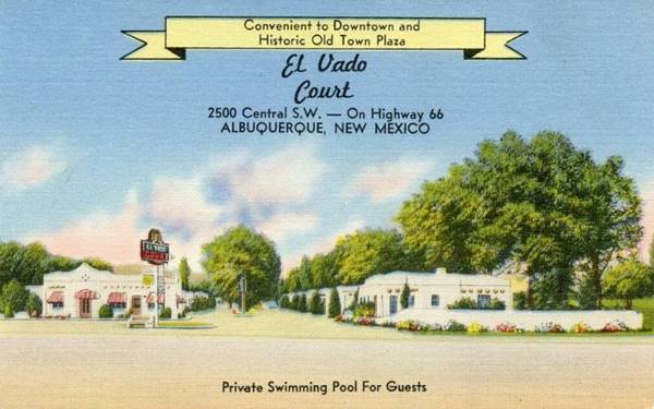
This motel opened in 1937 to coincide with the new Laguna cut-off alignment of Route 66 which bypassed the historic Rio Puerco bridge and headed straight out of town along Central Avenue and the new Rio Grande Bridge. It was owned by Daniel Murphy. The name "Vado" is the Spanish word for "ford". Rittenhouse mentioned it in his 1946 Guidebook to U.S. Hwy. 66.
It originally had 32 units and a filling station. It was built in Spanish Pueblo Revival style. Later a pool was added, the gas pumps were removed. Patrick O'Neal and his wife ran it in the 1960s. It ceased operating in 2008. But has been renovated and its neon sign recovered its former beauty and is still operating as a motel. Below are some then and now views.
El Vado Court Motel in a vintage 1950s postcard
The El Vado Court Motel as it looks today
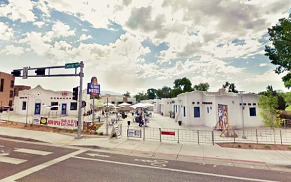

El Vado neon sign nowadays.

1960s Casa Grande Chevron and Cafe, looking east along Central. Source
Casa Grande Complex ❌
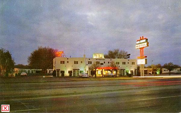
The Casa Grande (Spanish for "Big House") was a sprawling complex occupying the 2600 and 2700 block on the north side of Route 66 (right) opposite El Vado. It included several businesses on the property: the Casa Grande Motel, Casa Grande Inn and Casa Grande Lounge in the same building; and on the eastern side, the Casa Grande Cafe and the Chevron filling station pictured above (the image looks east along Central, and this is the same view in 2023.)
The Motel had a total of 141 rooms of which 24 were in the main two-story lodge building and 117 were courts. It had a swimming pool, coffee shop, phones in all rooms and television. You can see it in this 1955 aerial photo. It was torn down in the 1980s and now is where the Aquarium and Bugarium (bugs "zoo") are located. Below is a view of the main Lodge building and its neon sign in the 1960s.
Tingley Beach and Beach Motel ❌
Ahead, lying between the Country Club's golf course and Route 66, opposite Casa Grande, to your left on the 2700 block is the Beach Apartments complex. This was where the Beach Motel once stood; Rittenhouse mentions it in 1946.
Named for Tingley Beach, a recreational area on the eastern side of the Rio Grande south of Central Ave. it was a popular bathing spot in the 1930s and 40s. After it closed to swimmers in the 1950s it became a fishing spot. It was named after Clyde Tingley (1881-1960), New Mexico governor from 1935 to 1939.

Beach Motel 1960s. Source

Tingley Beach c.1935. Source
Route 66 Rio Grande Bridge

1931 Central Ave bridge across the Rio Grande. Source
Albuquerqe lies next to the Rio Grande, and there was a ford here used since prehistoric times. The shallow ford was located on the south side of Barelas, where the original Route 66 crossed the river. In 1807 it had been described as being "400 yards wide, but not more than three feet deep and excellent fording". But the first bridge crossed the river from the Old Town to northern Atrisco more or less where Central Ave. crosses the Rio Grande. It was a pontoon structure that opened in 1876.
A permanent timber toll bridge was built next to the pontoon one in 1882, charging a nickel to cross it. Both bridges were washed away by the May 1891 floods.
The Barelas bridge went up in 1910, a steel structure with a wooden deck. After a flood destroyed it in 1912, it was rebuilt and a concrete bridge went up next to it in 1920. This bridge carried the 1926-37 Route 66 through Isleta and Peralta (3)
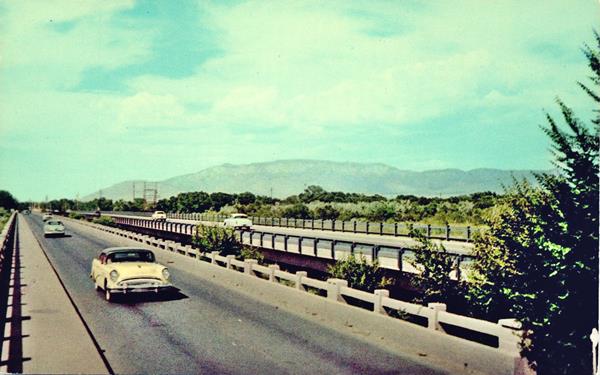
A new bridge spanned the river at Central Ave. in 1931, it was a 2-lane bridge known as the Old Town Bridge. Jim Ross in his Route 66 database details all the changes on this bridge: the original bridge was replaced by a new one date unknown, the eastbound lanes of Route 66 were aligned along it when a new bridge was built in 1952 to carry the westbound ones. These bridges were replaced by the current four lane bridge in 1983.
The image below looks west along the westbound lanes of Route 66 in the late 1950s. The Sandia Mountains can be seen in the distance.
Beyond the Rio Grande
Nine Mile Hill
The road now crosses the Rio Grande River and heads west. Rittenhouse described it in 1946 as follows: "Many tourist courts line the highway along here. Almost at the edge of town, you begin to climb the long, steep grades out of the Rio Grande valley, and onto the plateau". It was the famous Nine Mile Hill, all the way to the Rio Puerco River.
The topographic benchmark at the river reads 4,962 ft. and nine miles west it reaches 5,776 ft. in fact the climb continues to I-40s milepost 145, with an elevation of 5,894 ft.
This is a volcanic area!
The Volcanoes
The "Three Sisters" or Albuquerque volcanoes, and the West Mesa area formed simultaneously 150,000 years ago when the Earth's crust cracked and allowed magma to rise through it along a 5 mi. (8 km) fissure like a curtain of fire.
The Rio Grande Valley is actually a "rift", where the Earth's crust is thinner allowing lava to flow upwards, the valley to sink and the lateral areas to rise, like the Sandia Mountains to the east.
Getting there and what to do
The volcanos are about 8 mi. northwest of Albuquerque. Access from Exit 154 of I-40, head north along Unser Blvd. for 3 mi. to Western Trail, gateway to the National Monument. Below is a view of one of Albuquerque's volcanoes.
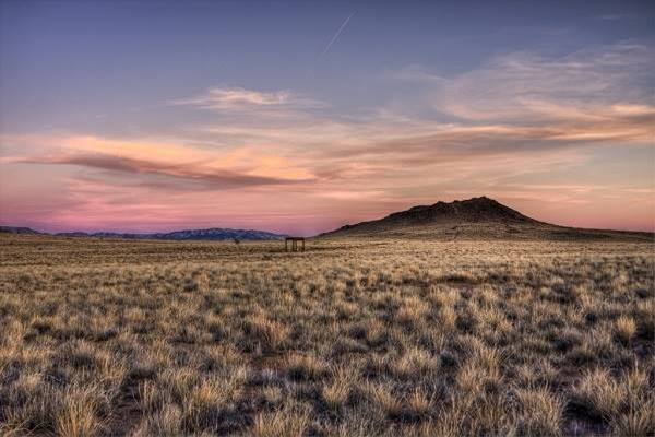
There are several trails from 0.8 to 2 miles long, from easy to moderately strenuous, which allow you to view the volcanoes by hiking around the cinder cones. Great views of the Rio Grande Valley and the Sandia Mountains. Take water with you. Parking lot is located at Atrisco Vista Blvd. NW (former Paseo del Volcan), about 4.8 miles north of I-40. (see Street View).
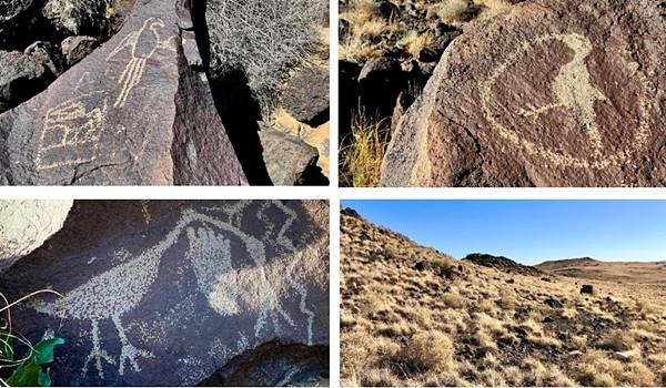
This volcanic area with the black volcanic rocks were sacred for the Pueblo people, who engraved their "petroglyphs" or rock art on them.
The National Monument is a day-use park that closes at 5 PM. Take your time (average hiking time through the park is from 1/2 to 4 hours). Stop at the visitor center is (at Unser Blvd. NW and Western Trail) for current park information, maps and brochures. Open 8 AM - 5 PM.
- Boca Negra Canyon. See some 100 petroglyphs along a paved trail guided with signs. Paid parking, drinking fountain and restrooms.
- Rinconada Canyon. A 2.2 mile round trip trail (no water) with 300 petroglyphs; 1.5 to 2 hour trek.
- Piedras Marcadas Canyon. A 1.5 mile rount trip trail (no water) with 500 petroglyphs; 1.5 hours.
More information at the National Parks website

Westwards along the Nine Mile Hill
Ruscha's Conoco Station
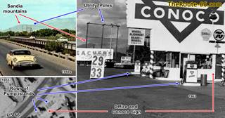
American pop artist Edward Ruscha lived in Los Angeles and drove frequently along Route 66 (he was captivated by it). His 1963 book Twentysix Gasoline Stations depicts black and white pictures of 26 gasoline stations along Route 66 with the location and gas brand sold. One of them is a Conoco in Albuquerque. No address has been given, but we believe that it is the Ever Ready Conoco Service located at 3900 Central SW. The gas station survived until the mid-late 1970 when the current building was erected on the property.
Edward Ruscha's Albuquerque Conoco, 1963©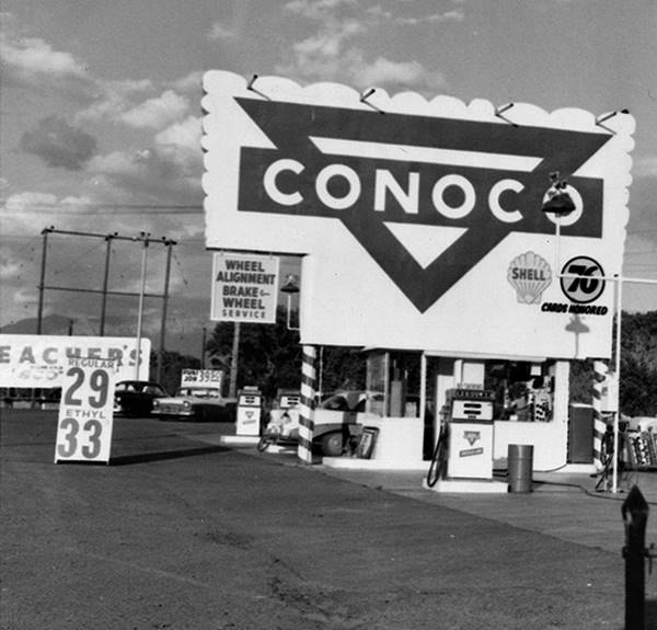
Ruscha's photograph shows a large Conoco sign by a box-shaped office, Route 66 runs to the left. The sandia mountains can be seen in the distance indicating that the picture looks east. Sun is behind the photographer, setting in the west. Two rows of two pumps each can be seen in the image and in the background, a wooden utility pole composed of three wooden poles and two cross-arms. This is identical to the view shown further up in the Rio Grande Bridge picture from 1959 showing Sandia mountains and the pole on the eastern bank of the river (in the distance above the yellow car). This 1955 aerial photo shows the rows of two pumps each and the shade of the Conoco sign, the 1955 shows more rows, but they decreased in 1959 and Ruscha was here in 1963. We combined all these views into a single image (click on it to enlarge it)
Across from it, on the north side at 3901 Central Ave NW was another gas station from the 1950s razed in the early 2000s.
Motel ?
The 1950s aerial photos show buildings on the NW corner of 40th and Central. This is the 4000 block (2800 under the old street number system) it is Rita's Apartments, and could have been a motel in the 1940s. At 4119 Central Ave NW, to your right, was Constancia Court in the 1950s and 60s. The next motels are on the 4500 block.
Duke's Court ❌
Mentioned by Rittenhouse in 1946, on the NW, at 4501 (3301 in the old numbering); you can see it in this 1967 aerial picture, the long thin building to the top of the image. All that remains is the former cafe at 4505 Central Ave NW now Dee's Hair Design. The motel was torn down in the 1970s. And the apartmnent complex was built in 1986.

Stop In Court. Source. Click to enlarge
Stop In Court ❌
Offering Modern Cottages at Reasonable Rates and only one-half mile west of the Rio Grande Bridge, this motel was also mentioned by Rittenhouse in 1946. It was adjacent to Duke's, on the right side at 4517 Central Ave. NW. Torn down in the 1980s. It had a Texaco gas station.
Adjacent to the Stop-In, Where the Pep's Boys shop is now located, at 4523, to your right (it used to be the 3323 of West Central) was the White Lodge Cafe and Court, ran by Jas K Shields. It had a U-shaped layout with the Cafe in the middle. On the north side of the highay. You can see it in this 1955 aerial photo.
Rainbow Court
Across the highway, to your left, at 4600 Central Ave SW, on the corner with 46th St., this was 3400 West Central under the old numbering system.
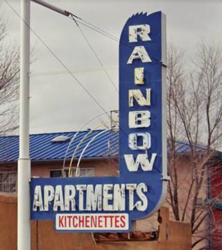
It was mentioned by Rittenhouse in his 1946 Guidebook Nice, and has preserved the original blue neon sign that now reads "Rainbow Apartments - Kitchenettes".
It is a Pueblo style building with two parallel sets of units. In the 1940s it was operated by Juan G. Serna.
The black and white picture below was taken in 1973 by John Schott, and it is a treasure for Route 66 historians, it shows the Rainbow's neon sign at that time where the word Rainbow was placed horizontally (now it is vertical) and Motel stood vertical.

Rainbow Court neon sign (detail) 1973. John Schott ©
El Nido Motel ❌
Nowadays, next to the Rainbow is the two-story Sandia Peak Inn at 4698 Central Ave SW. It was built in the 2000s and is a new addition and not relevant to the Golden Days of Route 66.
When this motel was built, the classic El Nido Motel that occupied the center of the block, and the Sandia Motel on the SE corner of Central and 47th were both torn down.
The El Nido (Spanish for "The Nest") was listed at 4604 Central Ave SW. It had a great neon sign of a sleeping man resting against a cactus, unfortunately lost. In the 1940s phone book it was ran by Loren F. Marquam and it was located at 3410. The Knotty Pine Cafe was on the corner. Below are two different views of the lost neon sign, the black and white one looks east, the color picture looks west:

El Nido Motel neon sign (detail) 1973. John Schott ©

El Nido Motel neon sign (detail) 1987. Steve Fitch ©
Both images were taken at different dates, this is the current Street view of the spot the second image was taken.
Adjacent to the El Nido was the Knotty Pine Cafe (3412) and Across Central, on its north side, opposite El Nido, to your right, was the Western Ho Cafe ❌ at 3405.
Sandia Motel ❌

Yellow pages ad of The Mikado
Adjacent to the Knotty Pine Cafe, on the SE corner with 47th St. was the Sandia Motel ran by Eitzen Danl (modern 4616-18 old 3414-16 Central Av W); Rittenhouse listed it in 1946.
At one time it was "The Mikado" as you can see in the Yellow Pages advertisement.
It was torn down to make space for the 1970s motel that now stands on the property. Below we compare two views of the building, its postcard from the 1960s and Fitch's 1987 photograph.

Sandia Motel and neon sign 1960s postcard. Source

Sandia Motel and neon sign (detail) 1987. Steve Fitch ©
Auto-Tel Court ❌
The old numbering of Central puts it at 3417. It was located where the gas station is now, on the NE corner of 47th and Central.
The Auto-Tel was run by Mrs. Olive Franklin in the 1940s and later, by Alva Haufman.
It was "Half mile West of Rio Grande on W. Central... 12 New Modern Insulated Units... Private Showers Automatic Hot Water" managed by Alva Hufman, it had an L-saped layout and two gas pumps in the courtyard selling Standard Oil products By the 1950s it changed its name to Westerner Motel and John Margolies took a picture of it in 1987 (see below).

Auto-Tel Court (Gone). Source
Click to enlarge

Westerner Motel, 1987. Source
Click to enlarge
Silver King's Auto Court ❌

Silver King business Card.
The next motel was Silver King's (Rittenhouse listed it), you can see it to the right in the folowing 1967 aerial photo (to the left is Millers, described below). It was located at what was 3515 (now 4711 where the gas station is) it was owned by Chas W. Beydler. Later it became the Hi-Lo Motel.
Miller's Court ❌
This Auto Court was next to the Silver King's at 3525 and owned by William Pinkston. Now it is 4801 Central Ave NW, where the West Central Storage is located.

Blue Bell Court advertisement 1940s. Source
Blue Bell Court ❌
It was located in what is now a vacant lot, to your left, at 4706 Central Ave SW. The Blue Bell Court was mentioned by Rittenhouse and its 1940s addresss with the numbering of that time was 3506 West Central. Mary V. Beadle ran it. It had a Pueblo style and offered "Innerspring Mattresses, Free Ice Water, Automatic Hot Water"
Head West. On the next block, to your left, after 48th St. there were three motels. All that remains are some neon signs:
Three Motels all Gone ❌
Relict Motel Signs
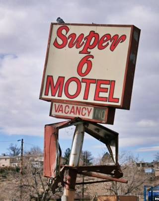
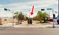
Ahead, on the south side of Central on the western tip of the 4800s block there are two neon signs, standing alone, solitary memories of two motels that once stood here between 48th and Cypress Dr., but were razed.
The 1940s phone directory lists several motels in the block that was in those days numbered 4600

66 Court neon sign Source
66 Court ❌
Adjacent to the existing building, an appliance store, was the 66 Court.
It was mentioned by Rittenhouse in 1946, and the 1940 phone book listed it at 3604. It was owned by Stratton Royal.
In the 1970s it became the Wilcox Apts. but was torn down shortly after.
Neon sign, pictured, vanished, maybe some collector has it?
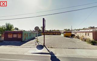
Royal Court (Later Super 6) ❌
Also mentioned by Rittenhouse. It was owned by Wendel Axnix (3606 Central in the 1940s).
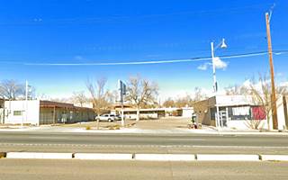
It had an L-shaped layout. Below is a street view from 2011 before it was razed.

Cibola Court c.1930s. Source. Click image to enlarge
The Cibola Court ❌
At 3614 West Central (now this is 4910), it belonged to Donald Ames. This Street View shows it in 2011 before it was torn down.
Opposite the Royal Court, was the El Rancho Court owned by Mrs. Viola L Gerkin at 3605 (1940s address). In the 1970s it became the Suntan Motel & Apartments.
More vanished buildings on the north side of Central Ave

Club Chesterfield.1930s. Source. Click image to enlarge
Next to it, opposite the Cibola Court, was the Cottage Motel at 3607 with a service station. Glenn Isaacson owned it. In the 1970s became an apartments complex. Where Auto Zone is now located was Club Chesterfield (3621-23). Pictured. It was a night club and bar with a Service Station, California Cafe (3625) owned by Chas Stevens. Glenn Campbell played here at the begining of his career in the 1950s in the band of his uncle Dick Bills.
Across 50th, on the NE corner was Joes One Stop Service Station old numbering was 3629. By the late 1950s it had gone. Head west to Yucca and Central
Approaching Yucca and Central
As you can see in this aerial photo from 1955 there were several motels at the intersection of Central Ave and Old Coors Dr SW to the south and Yucca Dr. NW to the north. Some have survived.
On the north side, to your right on the NW corner of 53rd and Central (3901 old numbers, now 5301) was the Skyview Cafe, followed by Victor's Super Service station (3903). Both gone. Ahead, also to your right was a motel:
Dutch Motel ❌

Dutch Motel (Gone). Source
Click to enlarge
The Dutch Motel was owned by Otto R. Schmitt it was located at what now is 5401 where the mall is located (3923 old numbering). Exactly opposite the junction of Old Coors Dr. and Central. Rittenhouse mentioned it in 1946.
Later it was managed by H. L. Utz. It had 18 units "18 Units - Showers - Air-Conditioned - Radio - T. V. in Rooms." Later it became the "El Molino" motel (Molino is the Spanish word for mill).
A service station was built next to it, with three service bays and a long flat canopy over two lines of gas pump islands c.1955, it stood on the NE corner of Central Ave and Yucca Dr. NW.
Hill Top Court ❌
On the south side of Central Ave. It had 25 rooms and offered "Hot and ice cold water in abundance... Radios... Tile floors and showers throughout." In the 1940s it was owned by Cecil T. Orton and by 1951 by Mr. and Mrs. C. T. Orton. It was at 4010 (old numbering), current 5410; it had been torn down in 2005 and in 2018 Yucca Dr. SW has been aligned across the property. The images shows a view of the motel in the 1940s and the vacant property with its steel pole for the long gone sign. We marked it with ④ in the image further down.

Hill Top Court (Gone). Source
Click to enlarge
The Motels west of Yucca and Central
The following black and white 1940s image (click on it to enlarge it) shows all the motels along Route 66 west of Yucca. It looks estwards along Route 66; the Sandia mountains can be seen in the distance and the numbers refer to different motels described in the text. The color picture shows the same view in 1951.

Looking East along Route 66 c.1940.Source
Click on image to enlarge

Looking East along Route 66 1951. Source
Click on image to enlarge
Arrow Court and Hill Cafe ❌
To your right, after crossing Yucca, (4500 old numbers, now 5419 Central Ave NW). The Arrow Court and Hill Cafe was owned by Myron Weiser in the 1940s.
The motel has gone, torn down in the 70s and now it is a parking space on the NW corner of Yucca and Central.
Navajo Court
The Navajo Court managed to survive, it was located at 5501 (4015 old number). Mentioned by Rittenhouse, it was owned by Earl Putzier, and the property is still standing, a typical U-shaped layout, with a corner office. Its matchcovers stated "You are a Stranger Here But Once... Reasonable Rates" (4). In 1959 it had 30 rooms and charged $5 and up! We marked it with ① in the image further up.
California Court ❌
Mentioned by Rittenhouse in 1946,it was ran by Jas Jaynes. To your right, adjacent to the old Navajo at 4025 old numbering (5509 nowadays) where there is a small mall. Street view, We marked it with ② in the image further up.
Alamo Court and Alamo Court Service Station
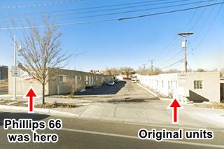
Next to the California, at 5631 Central NW (4035 old number) it was owned by Frank Vinke. Originally the units were in a single file on the eastern side, and the Phillips 66 station was on the western side. Rittenhouse noted it in 1946. A second line of units was built along 57th when the filling station was torn down in the late 1970s. The original units are still there, with a single floor, box shaped, Pueblo style look to them. We marked it with ③ in the image further up, notice the Phillips 66 to the left.
Allen's Court ❌
Opposite the California, on the south side of Route 66, to your left at 5500 where Julians Burgers N More is now located was Allen's Court (4110 old numbering), owned by Ms. Isabel Taylor. It had two parallel lines of units and a central office. We marked it with ⑤ in the image further up. The name was written on its western wall.
Mayflower Motel
To the west, also on the south side of Central Ave at 5602 (4120 old numbering) was the Mayflower Motel owned by Mrs. Angela Henery. We marked it with ⑥ in the image further up.
It is still standing and in good conditions.

Mayflower motel c.1950s. Source. Click to enlarge
El Campo - El Compo Tourist Court

April 1939 El Compo Court. Source. Click to enlarge
Listed in the National and State Register of Historic Places
At 5800 Central Ave SW (4200 old numbers), the El Campo Tourist Court (Spanish for "The countryside" or "the field") was also known as El Compo, with a letter "o", which has no meaning in Spanish. It was built and operated by M. H. McGraw in 1939 and at that time was described as "modern tourist apartments, filling station, store and trailer facilities". The April 1939 image (click to enlarge) states "New El Compo Tourist Courts, located 1 3⁄4 miles West of the bridge on Highwat 66. The Court consists of modern torust apartments, filling station, store and trailer facilities. Mr. and Mrs. M. H. Graw are owners of the new court." Rittenhouse mentioned it in 1946 when Milton Mc. Graw kept on running into the 1970s.
El Campo Tourist Court in a vintage 1940s postcard
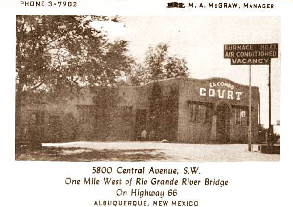
It has been restored and is now a private apartment complex; below is a current view of the site:
Across Route 66 (4209 old numbers) was Don H. Wallert's Restaurant (gone) and Hill Crest Service Station (4225 now 5827) on the NE corner with 58th the building is pictured above, a former icebox station with the service bays walled in.
Alta Vista Motel, later Whiting Bros. Motel - Americana Motel

1940s Alta Vista Motel. Source Click to enlarge
At 5908 (4210 old numbering) began as the Alta Vista Motel owned by William Vera in the 1950s it had separate units lined up in three rows (1955 aerial photo). By 1967 there was a single L shaped building on the eastern side of the property. By that time it was the Whiting Brothers Motel.
Whiting Brothers was established in 1926 by four brothers and it grew to have more than 100 gas stations from Texas to California as well as Motels, on Route 66 you can still see many of them
The Americana's neon sign is actually the original Whiting Bros. sign with the "WB" shield removed.

Whiting Brothers motel. Source. Click for larger image
Beside the motel, on its western flank, is the old Whiting Gas Station Sign which now is faded with the paint peeling off, with the words"Trailers" and "Gas".
ABQ Whiting Bros. gas station sign
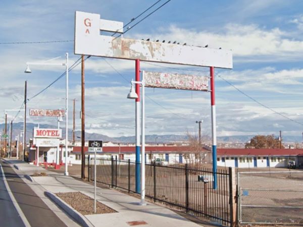
>> Read more about all the motels and gas stations of Whiting Bros. on Route 66
Hill Crest Motel, later Cactus Motel
Hill Crest Motel ❌
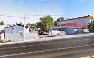
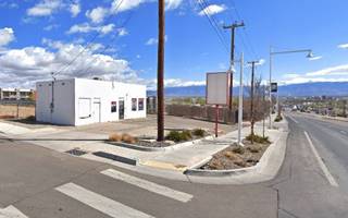
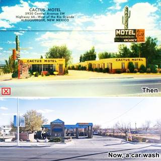
Just ahead (4228 old numbers) to your left, at 5930 Central Ave SW, is a car wash. This is where Bernard Feltman's Hill Crest Motel once stood; then it changed its name and perhaps its ownership to become Cactus Motel in the 1950s.

Cactus Motel and Whiting Bros c.1960s, Source. Click to enlarge
Cactus Motel ❌
Donald J. Lee (1927-2021) born in Tipton Oklahoma was a WWII veteran who married Alice Crumbley in 1953. They moved to Grants NM in 1961 and bought a trailer park and in 1962 they bought the Cactus Motel. He worked as a truck driver during this period and in 1972 they sold the motel (5).
"The Green Book"
In the days when many businesses were "White Only", "The Green Book" helped black travelers know where they could stop, spend the night or eat safely along the highway. This book, originally called the "The Negro Motorist Green Book" was published from 1936 to 1966 by Victor Hugo Green (hence its name). The 1963 edition lists four stops in ABQ, one of them the e from the 1963 edition showing the Cactus Motel as a friendly stop for African Americans. The Cactus appeared in all editions from 1959 to 1966 (6).
Sky Court ❌

Sky Court, gone. Source. Click to enlarge
The Sky Court (4330 old numbers) is where Earl Montgomery and Henry Gardner had the Sky Court. Now it is an empty lot. The place had a U-shaped layout with a central office as you can see in this 1955 aerial photo; it was named for a local airfield in Albuquerque (7) that opened in 1946, "Sky Court Airport" in eastern ABQ, there was another airport "West Mesa" closeby, by the Drive-in theater just west of the motel. Rittenhouse mentioned it in his Guidebook.
It was torn down in the 2000s, and at one time its stunted signpost stood facing Route 66 as you can see in this 2014 Street View.
Mile Hi complex partly gone ❌

Mile Hi Court 1930s. Source. Click to enlarge
This motel belonged to Woodrow W. Brewer, Rittenhouse mentioned it in 1946. The postcard (click to enlarge) placed it at 3850 West Central in the 1930s, but then it seems to have moved further west to this location in the 1940s when the local phone directory included the followint entries: Hi Mile Court (at 4320 old numbering), the Mile Hi Cafe (4324) and Mile Hi Garage auto repairs ran by James Edwards at 4330.
Based on the aerial photographs, and the lack of what is now 61st St. SW, these buildings coincide with the SE corner of 61st and Central for the Court and Cafe, and for the SW corner for the garage, the filling station is still standing, though modified (St. view.)
Siesta Court
Next door to the service station, at 4340 (old numbering) the Phone Directory placed the 1940s Neldoro Courts owned by Miller Nelso.
This motel is located at 6116 Central Ave SW and was later known as Siesta Court, pictured above. It has a J-shaped Layout and now is the 66-Apartments complex 1959 aerial photo.
La Hacienda Camp
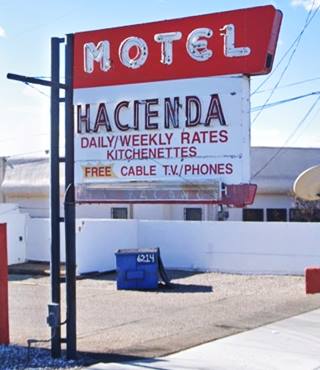
Just west, at 6214 Central Ave SW is the La Hacienda Camp. It dates back to 1947, the boom days for travel after WWII. Its postcard announced that it was "a bit of Old Mexico"; it had 21 rooms and a sunken garden (now gone); Thomas Mc Clelland owned it.
It has dropped the "La" from its name and is now the Hacienda Motel, but the neon sign is almost the same and so are the buildings, with a U-shaped layout around a central courtyard.
"Hacienda" is Spanish for a large estate like a ranch or a plantation. Below is a "Then and Now" view:
La Hacienda Camp in a vintage 1950s postcard
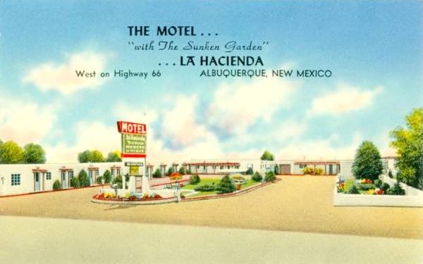
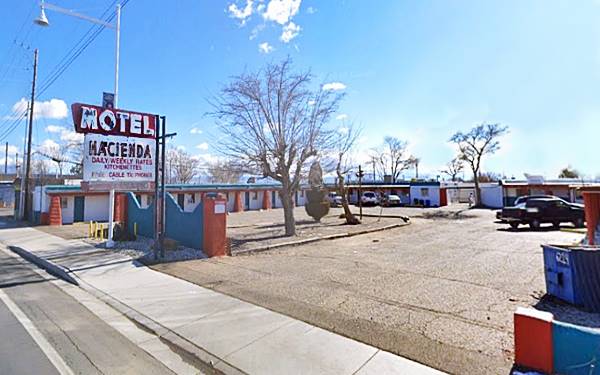
Across the street from the La Hacienda, is a kitschy Route 66 sign at Mac’s La Sierra pictured above, but there is an interesting story behind it.
Acoma Lodge - Sierra Motel - Mac's La Sierra Coffee Shop
Acoma Lodge ❌
Originally at 6217 Central Ave NW (4433 old numbering system) was the Acoma Lodge owned in the 1940s by Hubert Still. It survived until the late 1950s, when it is mentioned in the 1958 list of motels for a convention. The postcard (click on it to enlarge) dated 1952 tells us it had "Fireproof construction... Innerspring matresses. Mr. and Mrs. Ed. Russell, Owners-Managers," another mom-and-pop motel typical of that period. The building to the right (red arrow) became the Cafe it was owned by Jasper Wells McCarty (1910-1993) and his wife Alene nee Barton (1914-1972). In 1949 they moved from Clovis NM to Portales where they opened the first Mac's Drive-In. The family sold the restaurant in 1957 and moved to Albuquerque and opened a Mac's on Lomas. They sold the Central Ave. restaurant in 1965. But kept their chain "Mac's Steak in the Rough" for many years.

Acoma lodge. Source. Click to enlarge
Mac’s La Sierra Coffee Motel and Coffee Shop
Wacky Route 66 neon signs
At 6217 Central Ave NW, Mac's La Sierra Coffee Shop has a great neon sign with a steer on it, a good example of Wacky Route 66 Americana. You can see the steer in the 1960s postcard below, at that time it was placed on top of the roof
Mac's La Sierra Family Restaurant has been family owned in the city of Abq since 1951 with the La Sierra Motel and cafe; see this aerial photo taken in 1951
The postcard below tells us abot the motel in the 1950s: "La Sierra Motel & Coffee Shop... Twelve Modern Units... Paved Parking. Coffe Shop open 5:00 AM - 9:30 PM Daily. Excellent Food . Fine Steaks."
In the 1970s the motel was discontinued, to focus on the Restaurant.

La Sierra restaurant and motel c.1950s. Source. Click to enlarge

La Sierra restaurant and motel c.1960s. Source. Click to enlarge
Across Central, just west of the La Hacienda, at 6304 Central SW, (old number 4430) was Albinus Whitsett's Service Station torn down in the 1970s. The odd shaped building next to it, with a hexagonal hip roof on each of the three buildings facing Route 66. It appears in the 1951 aerial photo of the spot, probably a home or a store at that time (street view.)
Covered Wagon Court
Ahead, to your right at 6401 Central Ave NW. though its business card gave 6407 as its address. On the NW corner with 64th St., by the Albuquerque Gateway arch, is George Ruggles' Covered Wagon Court from the late 1940s. It has a single story with a gable roof and L-shaped layout and a classic neon sign fading among the branches of the tree on the corner. It portrays a prairie schooner.

Covered Wagon neon sign in 1987. Source. Click to enlarge
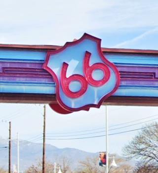
US 66 Gateway Arch
The arch with Navajo decorations and a Route 66 shield in its center spans Central Avenue next to the motel.
Western View Diner & Steak
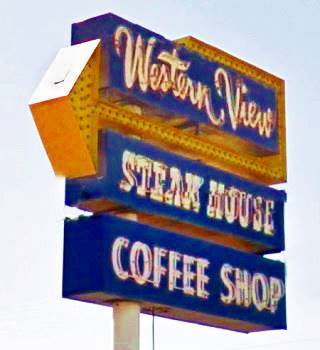
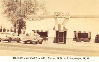
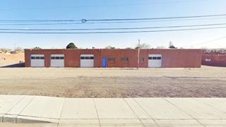
6411 Central Ave NW (old numbering 4511) on the western side of the gateway. It has been serving meals on Route 66 since 1949. At one time it was Ray Cross' Lavaland Cafe that burned donw in 1947 and was replaced by the Desert-Vue.
To your left, on the south side of Central (6420 SW), the H & D Tire Center has been there since the late 1950s, a gas station with a glazed corner office and two service bays, pictured above. The building to its left is more recent (early 1990s).
Hubbell Motel ❌

Hubbell Motel c.1940s-50s Source
Click to enlarge
Ahead, to your left, on the now vacant SE corner of Coors Blvd SW and Central Ave was Hubbell Motel. Its address according to postcards and yellow pages changed over the years from 6502 to 6512 Central Ave SW. The motel had nineteen units with 24 rooms and was "A very modern and attractively furnished motel." It was built by Mason Hubbell in 1951. Demolished in the 1980s. Its sign at Coors and Central remained until just recently.
Ahead in the modern 6600 block was (4734 old numbering) Roy Palmer's Crossed Arrows Trading Post ❌
Oasis Lodge ❌
At 6904 Central Ave SW, in what is now the vast parking lot of the former Verizon Call Center, once stood the Oasis Lodge, its postcard had some interesting information "... Tile combination tub and showers. Owned and operated by David & Gladys Brown. On U.S. Highway 66 - Telephone CH 2-1878. Collector of Antique Colt Pistols." Pictured below and you can also see it to the left in the Acoma Phillips 66 gull wing station image.

Oasis Lodge c.1960s Source
Click to enlarge

Acoma Phillips 66, ABQ c.1960s Source
Click to enlarge
Phillips 66 Gull Wing ❌
Located at 6920 Central Ave SW, the old Acoma Gull Wing Phillips 66 gas station was ran by John S. Gadomski and was known as the "Acoma Phillips". It burned and was partly restored. The City of Albuquerque listed it as a historic gas station, later known as J&J Texaco Service. It can be seen in this 1959 aerial photo.
66 Drive In Theater
Ahead was the West Mesa Airport with Airport Drive as its access road. Here was Cutter Carr Flying Service Station (Gone). On the NW corner where Airport Drive and Central meet, at 221 Airport Drive NW was the 66 Drive In theater. It opened in 1949 and could fit 400 cars, later expanded to 557 cars and 40 seats for walk-in customers. It closed in 1956, reopened in 1964 and closed for goood in 1983. You can see it in this 1955 aerial photo.
Adobe Manor

Adobe Manor motel and neon sign nowadays. St. view. Click image to enlarge
Drive west for 0.3 miles, and to your left, on the SE corner of Central and 75th St. is the Adobe Manor (7412 Central SW). It was "Johnson's Motel" in the 1950s and by 1959 it was "Rushmore Motel"; now it it the Adobe Manor. Its classic neon sign is the work of the Zeon Sign Company that made it in 1966. You can see the motel in this aerial photo taken in 1951 (to the right; on the left is the Westward Ho Motel).
Westward Ho Motel and Cafe

Westward Ho c.1950s Source
Click to enlarge
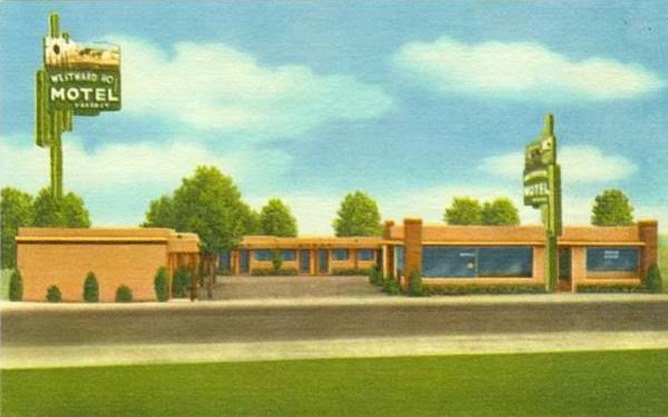
Also to your left, across 75th St. on the SW corner at 7500 Central Ave SW (5004 old numbering). The motel's name evokes the rallying call to explore and settle the American West.
Its first neon sign was different as you can see in the first postcard when it was owned and managed by Mr. and Mrs. Leo Zimmerman (click on it to enlarge).
The postcard reads "A Modern Court (Completed 1950) with Franciscan Furniture... Sanitized daily for our protection - and all drinking utensils individually sterilized." I wonder why they were so obsessed with cleanliness?
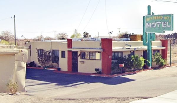
The later postcard pictured further down, posted in 1961 when it was owned and operated by Ed and Coinnie Keeley already includes the saguaro cacuts-shaped neon sign.
The saguaro (Carnegiea gigantea named so in honor of Andrew Carnegie) is a cactus that carn grow to 40 ft (12 m) tall, it is found in Arizona, SW California and Sonora in Mexico. It has branches known as "arms". Surprisingly, none grow in New Mexico. Below is a closeup of this classic neon sign.

Westward Ho! Motel neon sign. St. view
Westward Ho Motel with the saguaro cactus neon sign 1961
Jerry Unser's Garage and Gas Station
Ahead, to your left, at 7700 Central Ave. SW at 5220 (old numbers), was Jerry Unser's motor rebuilding service and next to it, at 5226 West Central -old numbering- his Jerry's Automotive Service Station; this 1951 aerial photo shows the buildings.
Jerry Unser, Senior opened his gas station in 1935, and when he retired his son Bobby Unser took it ovre. He opened the motor rebuilding plant next to it and specialized in foreign car parts and service place out of it and did pretty well. Boby closed the shop in 1968 as he was too busy racing (he'd won the Indy 500 in May '68). He was a famous American racecar driver, champion of the 1957 USAC Stock Cars his sons were all racecar drivers

Unser's Garage in 1955. Source
Click to enlarge
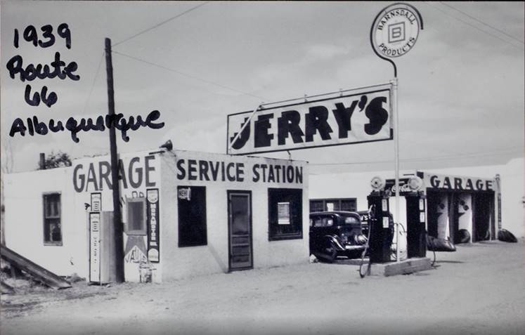
Jerry Unser's Service Station in 1939. Source
Click to enlarge
The image from 1955 looks eastwards along the south side of Central Ave. the red arrow marks the Westward Ho Motel.
Ahead the highway crosses the aptly named Unser Boulevard.
Drive west for one mile and when you approach 94th Street, to your left is a classic motel and gas station.
French Quarter Motel (former Apache Lodge)
At 9317 Central Ave. NW (old 5945 West Central) is the former the Apache Lodge with "Private Baths Kitchenettes ON U.S. 66 Moderate Rates Innerspring Mattresses - Coronado Furniture." Later it became the "French Quarter", still standing. Below are both Apache and the French Quarter:

1940s Apache Lodge. Source
Click to enlarge
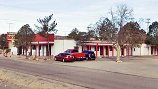
Across the highway, on the SW corner of Bridge Blvd. SW and Central are two buildings: to the east at 9200 Central Ave SW, is the Cafe 66 New Mexican Restaurant location of a scene in Breaking Bad it dates back to the early 1960s. The other is Penske Truck rental, to the west, built around 1958, but greatly modified from the 50s.
Old Gas Station M&S
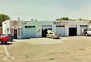
Across 94th, on the SW corner with Central (9400 Central Ave SW), this gas station appears in the 1959 aerial photo, a gas station with five service bays and no canopy or pump islands; it is listed as a "Historical Auto Station", Safe Lane Auto (8).
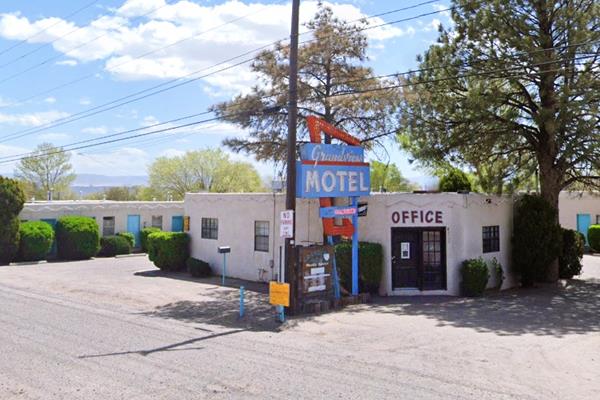
Grandview Motel, ABQ's westernmost motel
Head west, just ahead, to your left, at 9700 Central Ave SW is another motel that was built in 1954, with an L-shaped layout, just before you reach 98th St. The Grandview Motel was the first motel that eastbound travelers encountered as they reached Albuquerque. It was first owned by Russell Farber.
Grandview Motel in a vintage 1960s postcard
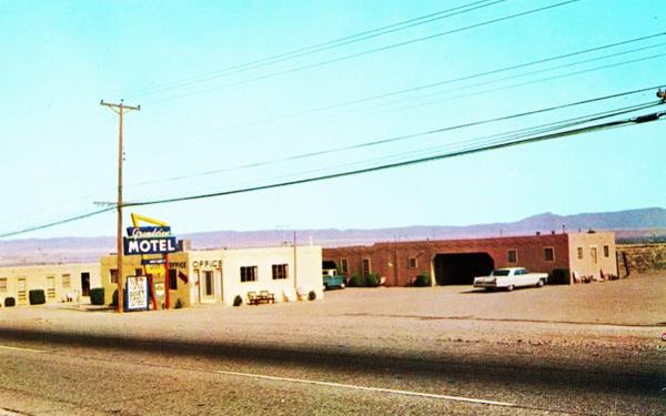
The motel has survived with the same layout and neon sign (with a different color scheme) and plenty of trees:
Route 66 Conoco
This area in the 1950s and 60s was open space and there were few buildings and side streets. The next landmark was the Route 66 Conoco, another "Historical Auto Station", at 9722 Central Ave SW. On the SE corner with 98th St.
West of this point there were several gas stations, the last chance before the desert. They are all gone: MAc's Truck Terminal 10600 Central Ave SW, Whiting Bros (now Hererra Coaches) 10605 Central Ave NW, Dick and Paul's Service, 11616 Central Ave SW, Nine Mile Hill Chevron, 12504 Central Ave SW, Hilltop Shamrock at 12605 Central Ave NW.
The Westernmost part of Albuquerque
Leaving Albuquerque
Camino Real Marker
Two miles west of the Conoco, to your left (at the landfill) is a marker (Street view). It reads: "Albuquerque - On the Camino Real - Spanish settlers had lived here before the Pueblo Revolt of 1680, but the area was resettled when the "Villa de Alburquerque" was founded in 1706. In addition to promoting colonization, the new town was intended to provide protection from attacks by Indians in Rio Abajo, or lower Rio Grande Valley." The back of the marker has a map of the area. Just 0.4 miles ahead, the original Route 66 meets I-40 at what is now Exit 149. Here the highway - Central Ave followed the alignment shown with a violet line (0.8 mile gap in the current alignment) which is cut by the freeway; it continues as the North Frontage Rd. The two 1950s eastbound lanes of Route 66 were buried by I-40s WB lanes in 1970. This 1951 aerial photo shows what Exit 149 looked like before I-40 was built.
Towards the top of the Nine-Mile Hill
The Enchanted Trails Trading Post and RV Park dates back to the 1950s, it was originally located in what is now the median of the Freeway and in the mid 1960s moved to its present location at 14305 Central NW.
Hilltop Trading Post ❌

1940s Hilltop Trading Post. Source
Click to enlarge
Three miles west, at the top of the hill, by milepost 145 was the aptly named Hilltop Trading Post with a cafe and service station; the foundations of the buildings can be seen on the north side of the frontage road (Satellite view) there was another building with poles stuck in the ground like giant arrows, a trading post and gas pumps on the south side of the old four-lane 66 alignment; on its eastbound lanes, but it was torn in 1970 down when the original roadway was replaced by I-40's.
Rio Puerco Bridge
The highway headed west for another 4.5 mi. all the way to the Rio Puerco River (map to Exit 140) where Exit 140 disturbed its alignment; the gap is marked with a green line here.
Located on the north side of I-40, on old US 66 in Suwanee, NM.
Listed in the National Register of Historic Places
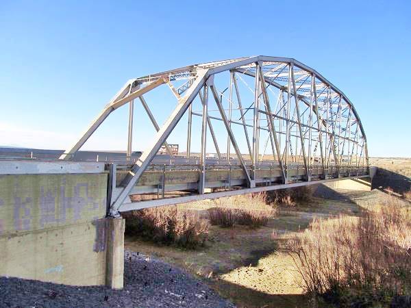
Though the Rio Puerco is usually dry, it can flood and carry large volumes of water. For this reason the State Highway engineers chose a Parker through truss bridge to cross it.

Rio Puerco
The Rio Puerco is a tributary of the Rio Grande. Its sources are on the west slope of the Nacimiento Mountains and it flows 230 mi. (370 km) with a north to south course before meeting the Rio Grande about 50 mi. (80 km) south of Albuquerque.
It is a temporary river, and is dry during part of the year. Its average discharge is about 39.5 cu.ft.⁄s. (1.12 m3⁄s).
The name refers to its muddy and dirty waters (puerco is also "pig" in Spanish).
This kind of bridge does not need a center pier to support it, and therefore eliminates the risk of it being washed away.
The placement of the bridge was strategice: on a narrow location with steep banks it was suitable for the 250 foot long single span bridge.
The bridge was built in 1933 on NM State highway 6, employing federal funds for highway construction. It was part of the plan to shorten the transcontinental route and became part of Route 66 in 1937 when the "Laguna Cut Off" was implemented, bypassing Isleta and Los Lunas.
The bridge's deck is 25 feet wide and was remodeled in 1957. When I-40 absorbed the traffic of Route 66, it became its Frontage Road until 1999 when the NM Transportation Department replaced it. It is open to pedestrian traffic.
Rio Puerco Bridge, historic landmark
The Rio Puerco Trading Post once stood here, where the 66 Pit Stop is now located. On the south side of the river there was another gas station, also gone (aerial photo).
Route 66 Travel Center
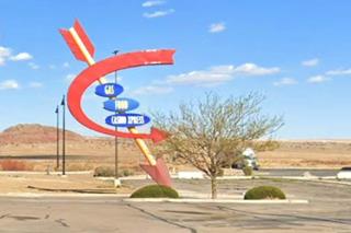
Across the Freeway a modern casino complex, the Route 66 Travel Center offers some interesting retro-styled signage with Indian arrows and a 1950s-look to them!
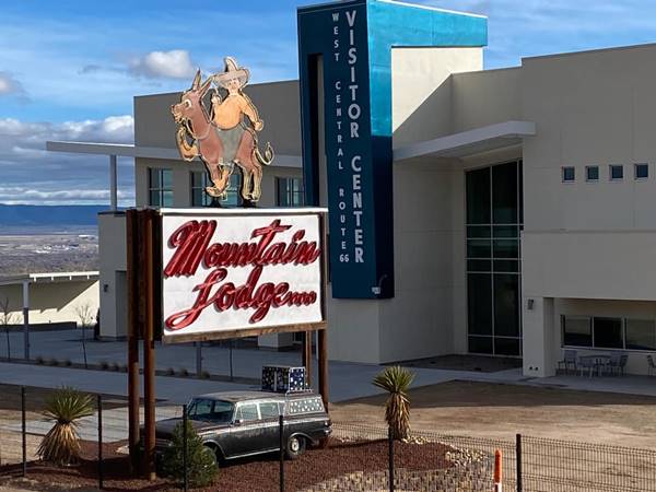
Route 66 Visitor's Center in Albuquerque is the home of the Old Carnuel Mountain Lodge neon sign pictured below. It has been repainted and now stands by the new Center:
The old Mountain Lodge neon sign in its new home: West Central Route 66 Visitor Center at Nine Mile Hill
Your Albuquerque Route 66 Road Trip leg ends here
Here, at the Rio Puerco is the endpoint of this leg of your Road Trip across Duke City.
The highway from here all the way to Lupton Arizona is described in our Albuquerque to Lupton segment; it has plenty of maps and information about the original roadway.
You can continue west along Route 66 to visit Suwanee, the next town on this leg of your Road Trip, or head back into Albuquerque and enjoy your stay there.
Continue West into the Old Town and Western Albuquerque
Continue your Road Trip heading west along Route 66 ⁄ Central Avenue into the Old Town and Western Albuquerque.
Read all about the Old Colonial Town and Western Albuquerque's Route 66 attractions in our Next Page.
The Route 66 Attractions in Albuquerque
Albuquerque is, after St. Louis and Oklahoma City, the third largest city between its two endpoint megacities, Chicago and Los Angeles. However, it has preserved far more classic landmarks along Route 66 than any of the other cities.
We have split this segment of your Route 66 road trip across Albuquerque into six separate webpages, to be able to mention all of them. They are, from east to west, the following:
- Main Page: Albuquerqe overview, hotels, history, maps
- Page 1. Eastern Albuquerque
- Page 2. Nob Hill
- Page 3. Downtown
- Page 4. Colonial Town & Western Albuquerque
- Page 5. 4th St. Route 66 - 1926-37 Sights
Continue your Road Trip westwards beyond Albuquerque
After covering eacho of our four webpages you will have reached western Albuquerque, the endpoint of your Route 66 acreoss the city. You can continue your Route 66 road trip by heading west into the next town, Suwanee NM on the 1937-85 alignment or Isleta on the 1926-37 alignment.
Sponsored Content

>> Book your Hotel in Albuquerque

Credits
Banner image: Hackberry General Store, Hackberry, Arizona by Perla Eichenblat
Jack DeVere Rittenhouse, (1946). A Guide Book to Highway 66.
Hubbell Motel image sources: Source 1 and Source 2.


