Route 66 in Carnuel NM
Index to this page

TheRoute-66.com is reader-supported. When you buy through links on our site, we may earn an affiliate commission at no additional cost to you.
About Carnuel, New Mexico
Facts, Trivia and useful information
Elevation: 5,860 ft (1,786 m). Population: 1,027 (2020).
Time zone: Mountain (MST): UTC minus 7 hours. Summer (DST) MDT (UTC-6).
Carnuel Village is located in Bernalillo County, NM, on the western slope of the Sandia Mountains in the Tijeras Canyon, on Route 66's 1937 alignment.
The canyon where the town is located has been a strategic route linking the Rio Grande River with the Sandia and Manzano Mountains to the east. The Arroyo Tijeras (dry most of the time) runs down the canyon from east to west, ending as a wash in the flat area south of Albuquerque.
To the east, the canyon links with the high desert area and was a route towards the Pecos River. Route 66 was aligned along this ancient trail.
People have lived here for more than 10,000 years (the site at Sandia Cave is proof of this). More recently, the Pueblo people settled in the Tijeras Canyon; the ruins of Tijeras Pueblo ("pueblo" is the Spanish word for "village") can still be visited. This small town was built around 1300 AD.
The Spanish explored New Mexico in the mid-1500s and settled in Santa Fe in the early-1600s. Catholic Missionaries converted the natives, but they rose in rebellion in 1680 and evicted the Spaniards, razing towns and missions. Twelve years later, the Spanish returned and regained control over parts of their former colony in Nueva Mejico.
The name: Carnuel
"Carnuel" is probably a corruption of the native Tiwa name for this place: "Carna-aye" which means "badger place".
The American badger (Taxidea taxus) is a short-legged omnivore mammal which are part of the family Mustelidae which also includes otters and weasels.
The settlement of Tijeras Canyon was slow. Following the resettlement of Santa Fe in 1692, Albuquerque was founded in 1706. In 1762 a group of people requested a land grant in Carnué Canyon. Governor Tomás Vélez Cachupín confirmed the grant the following year. Shortly after the settlers founded the village of San Miguel de Laredo de Carnué to control of the strategic canyon and to act as a buffer for Albuquerque and shield it from the Apache raids. However, it would be short lived. The aggresive natives forced the retreat of the Spanish. On May 27, 1771, Alcalde Navarro gave the order to abandon the settlement.
In the meantime the name "Carnué" became "Carnuel", a name which was applied to the canyon known today as Tijeras. (due to the scissors-like meeting point of the Carnuel and Cedros Canyons).
In 1819 another land grant was assigned by Josef de la Peña and new settlers moved back up the Canyon, establishing Tijeras and 24 families resettled in what is now Carnuel. But the Apache Indians raided the town, and lack of water was a serious issue. Many families moved back to Albuquerque or to San Antonio (north of Carnuel). The area was ceded by Mexico to the U.S. after its defeat in the Mexican - American War (1846-48) and it became the U.S Territory of New Mexico. By 1880 only 10 families remained, and they were the basis of modern Carnuel. They faced the attacks of the Comanche and Apache.
In 1903 president Theodore "Teddy" Roosevelt confirmed with a Patent the ownership of local residents of 2,000 acres of land (out of the original 48,000 acres).
The old native and colonial trail became a highway when the U.S. government implemented the National Highway System in 1926, it was named US 470 and linked Albuquerque with Moriarty and Willard, then it took the number US 366. Finally in 1937, Route 66 was shortened and realigned through the Canyon and Carnuel. The "Santa Fe cut-off" incorporated former US 470. Later, when Route 66 became too crowded and unsafe (see below the Dead Man's Curve), it was upgraded to a four lane highway in the 1950s. Later, in 1965, I-40 was built alongside it, crossing the mountains through the Canyon.

Where to Stay: Hotels in Carnuel
Neighboring Moriarty and Albuquerque have plenty of lodging options for those travelling along Route 66, you can book a hotel or motel in town:
> > Book your Motel or Hotel nearby, in Albuquerque
More Lodging Near Carnuel along Route 66
Below you will find a list of some of the towns along Route 66 in New Mexico. Click on any of the links to find your hotel, motel or accommodation in these towns (listed from east to west);
On Route 66's Main alignment
The Santa Fe Route 66 segment
Eastwards
Westwards
>> There are RV campgrounds in Tijeras, Edgewood, and Albuquerque.
The weather in Carnuel
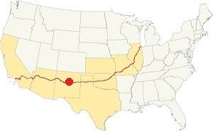
Location of Carnuel on Route 66
Carnuel is located on the western slope of the Sandia Mountains, and the weather is dry but wetter than in the City of Albuquerque.
The climate is dry and sunny. The relative humidity is low. Albuquerque has an arid desert climate with hot summers and cold winters. There are on average 278 sunny days per year. Spring is warm and windy with some rain, but otherwise it is the driest season. In May the temperature increases. Summer is dry, which makes the heat bearable. But most rain falls during the summer monsoon season from July to September. Fall is warm with cool nights and little rain.
Shielded by mountains, snowfall is quite low and total precipitation is arount 11 inches per year (279 mm). Snow is around 10 inches (25 cm) per year.
The average summer high temperature (Jul) is 88°F (31.1°C) with a low of around 54.5°F (12.5°C).
The winter average low temperature (Jan) is around 15°F (-9.4°C), the high averages 44°F (6.7°C)
Tornado risk
Carnuel is located in an area with virtually no tornado risk: Bernalillo County has no Tornado watches.
Tornado Risk: read more about Tornado Risk along Route66.
Map U.S. 66 in Carnuel New Mexico

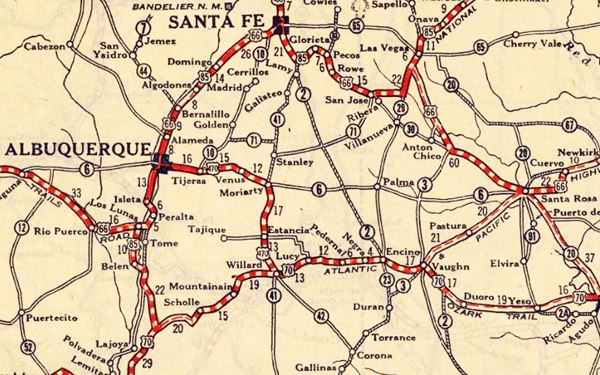
1937 roadmap near Carnuel Source
Click to enlarge
The historic 1926 alignment of Route 66 following the National Old Trails ran further north following an ample curve which headed from Santa Rosa towards Las Vegas, NM and Santa Fe. From there it headed southwards, to Albuquerque.
Carnuel was located on the short lived US 470, that later became US 366 named so because it was a spur of the Santa Fe Loop US 66 (see map below, it appears as US 366).
The "Santa Fe cut-off" shortened the road with a direct alignment from Santa Rosa to Albuquerque through Moriarty, Edgewood and Carnuel. This section was completed in 1937 along a new roadway to Moriarty and then along US 366, that became US66 into Albuquerque.
The thumbnail map -click on it to enlarge it- shows Moriarty on the lower right side, with no Route 66 running right towards Santa Rosa. It shows US 366, Edgewood, and a winding highway through Barton, towards Sedillo, Tijeras and Carnuel. The 1937 alignment of Route 66 has now become NM-333, which runs on the south side of I-40.
Route 66 alingments in Carnuel
There were several alignments over the course of the year along lower part of Tijeras Canyon. Further down we describe them at Dead Man's Curve
The original two-lane highway was upgraded to 4-lanes in the 1950s.
We have marked several of the old alignments in our custom map, and color coded them as follows, others can still be driven:
- Tijeras to Carnuel: violet line is the 1930s-50s alignment.
- Into Deadmans Curve map (driveable)
- The 1930s to 50s 2-lane highway is marked with an Orange line at Deadmans curve.
- From Deadmans to eastern Carnuel the highway followed this alignment map and it can be driven.
- Final segment, red and blue where the blue line marks the 1930s-50s dual lane highway and the red ones are the westbound lanes added in the 1950s. There is a short surviving segment of the old EB lanes on Herrera Dr. (map)
Route 66 Alignment near Carnuel
With maps and full information of the old roadway.
- Albuquerque to Lupton (next)
- Santa Rosa to Albuquerque (Carnuel's)
- Tucumcari to Santa Rosa (previous)
The Santa Fe Loop (1926 - 1937)
Our Santa Fe Loop page describes the complete 1926 to 1937 alignment of Route 66 from Santa Rosa to Albuquerque through Pecos, Santa Fe and Bernalillo.
Carnuel: its Attractions
Landmarks, Route 66 sights
Historic Context
Rittenhouse in his 1946 guidebook of US Highway 66 does not mention Carnuel by name, instead, he wrote about the canyon:
After a few more twists and dips, you suddenly come out of Tijeras canyon... Opening before you is the wide valley of the RIO GANDE in which the city of Albuquerque is located... Rittenhouse (1946)
He places this spot 6 miles west of Tijeras and 9 from Albuquerque roughly halfway between I-40s exits 170 and 171. One of these "twists" was surely the Dead Man's Curve.
Carnuel its Attractions
As you drive west from Tijeras, just after the site of the now gone Western Tijeras Canyon Marker, the original Route 66 entered Deadmans (or Dead Man's) Curve.
Dead Man's Curve
On the western side of Canuel, Tijeras river passes through a narrow section of the Canyon, where it turns north and then west again. The locals called it "La vuelta de las Cuchillas" which in Spanish literall means "The Turn of the Knives", however "Cuchillas" also means a steep knife shape mountain; the latter is a better description of the spot: a deep narrow valley with towering hills on both sides and an "S" curve in the river.
1. Original alignment at Deadmans Curve
We marked it with a black line in our custom map
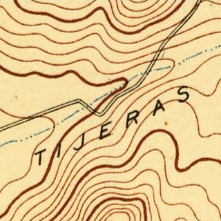
The map below, from 1890 shows how the original dirt highway up the canyon crossed the river twice, on both sides of the canyon -click on it to enlarge the map. It avoided any cuts; the higway went down to the river and followed the steep hills on its southwest and southern banks.
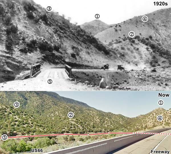
The image below combines a current view with a 1920s picture lookingwest along the road. You can see the same features in both numbered (1) to (5). The red line marks the approximate alignment of the old highway, along the south and western side of the canyon. Dashed line shows where it is obstructed by the hill and I-40 embankment on that nowadays cuts the river and obliterated the original alignment. The 1950s four lane Route 66 can be seen (lower left) on the bottom image.
There was another alignment from the 1930s to 1950s that was built hugging the northern and northeastern side of the canyon but it too was destroyed when the 1950s alignment replaced it. I-40 removed another part of the old section, but you can still see the western part of this 1930s-50s roadbed (more on this further down).
2. 1926-50s two-lane highway
We marked it with an orange line in our custom map
From 1926 to 1937 US 470, later US 366 ran through Carnuel. In 1937 it became Route 66. It was a two-lane highway that was straighter than the original dirt trail. So a new alignment was built along the north side of the Canyon. The roadway clung to the slope, on its wester side an embankment was built and close to the curve a cut was made in the slope, at the curve, the SW tip of the hill was cut and a sharp curve followed. The highway climbed up to the cut, and then down towards the river on its eastern side. This cut on the hill's tip was later deepened by the 4-lane highway to reduce the grades and finally eliminated by I-40 that plowed across it.
Below are some postcards looking east along the canyon towards Dead Man's Curve, click on them to enlarge:

1930s view Dead Man's Curve, Carnuel. Source
Click image to enlarge
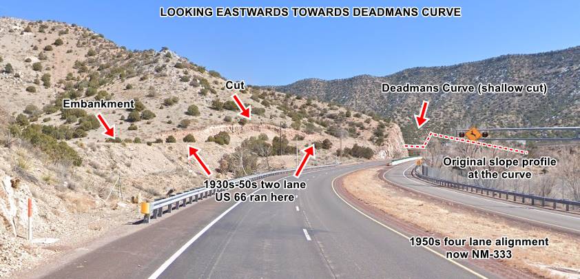
Current view Dead Man's Curve, Carnuel. St. view
Click image to enlarge
In the 1930s image you can see Child's Motor Court to the left, and the winding Route 66 climbing towards the curve.
3. Four Lane Route 66 (1950s)
The increase in traffic and safety concerns led to a four-lane highway being build in the 1950s. This aerial photo from 1951 Shows the four lane road under construction at the curve.
The first postcard below (Click on both of them to enlarge), from the 1960s shows the curve itself. Now I-40 cuts across here, and it eliminated the original curve (1930s-50s '66) that we marked with a red arrow (upper left):

Early 1960s view Dead Man's Curve, Carnuel. Source
Click image to enlarge

Early 1950s view Dead Man's Curve, Carnuel. Source
Click image to enlarge
The second image above shows the same view shown in the 1930s and current picture looking east along the Canyon towards the cut at its SW tip. Notice how it has grown deeper.
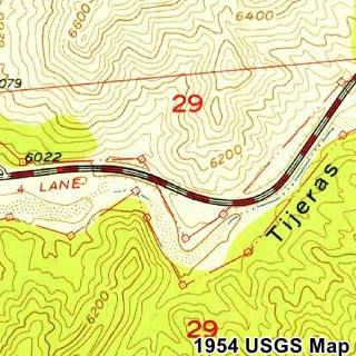
The USGS map published in 1953 shows the four-lane US66 in Deadmans at that time.
4. Freeway
By 1980 (1981 aerial photo) the interstate had been built in a straight course across the curve. The old four-lane '66 became NM-333, and it passed beneath I-40 at the curve.
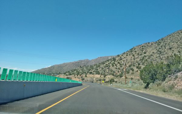
Below is a view looking west, notice the cut of Old 66 on the slope ahead.
View along Route 66, heading west after the former "Dead Man's Curve" at Carnuel
Other Dead Man's Curves on Route 66
There were more deadly sharp curves on Route 66, follow the links to learn about them:
Into Carnuel
Tijeras Canyon Trading Post & Child's Motor Court
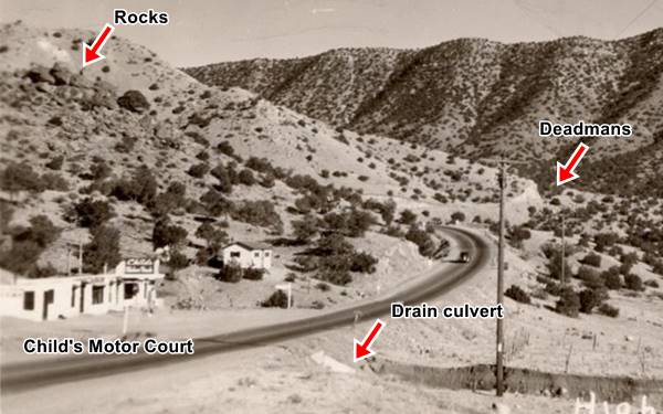
Drive west from Deadmans and to your right is the site of a former motor court and trading post. Above is a picture of it c.1930. The sign reads "Child's Motor Court".

1930s Trading Post with "Snakes" sign, Carnuel. Source
Click image to enlarge
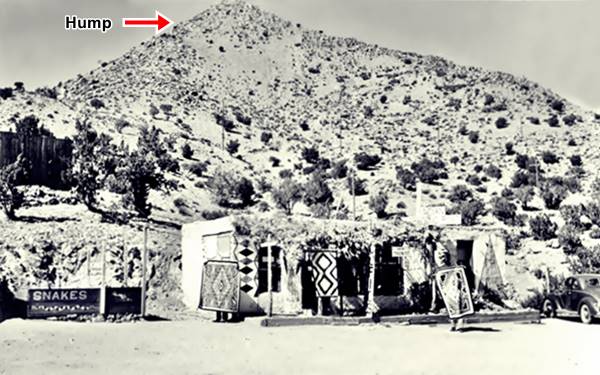
Another image of the same spot, at roughly the same time shows the old Tijeras Canyon Trading Post there, the sign to the left reads "Indian Curios. SNAKES". Notice the same outcrop of rocks on the hill behind the building, and, to the right, the same gable roof building on the hill.
We believe the auto court replaced the trading post late 1930s or early 1940s. It can be seen in this aerial picture taken in 1951 (the building with a gable roof also appears in the shot). It was located on what is now Atanacio Rd. NE, the original alignment of Route 66 here.
The same spot nowadays can be seen below: we marked the same rock formation on a hill (upper left), the drain culvert runs beneath the spot where the photo was taken.
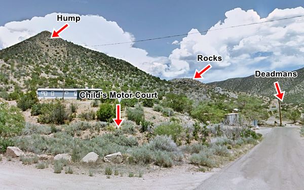
The image also shows a hump-shaped mountain that can also be seen in the following image, of the trading post (notice the men holding up native rugs):
Musical Highway
The Singing Road
Here you can turn around to drive back, eastwards to dive along the Musical Highway, it is 1.1 mi away as shown in this map with directions.
Along Route 66 west of Tijeras as it aproaches Deadmans.
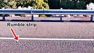
This is a special section of highway, it is a 1,300 foot segment where rumble strips have been placed in the pavement that "play" the song "America the Beautiful" when a car is driven over them at exactly 45 miles per hour (by the way, that it is the speed limit in this part of the road).
The musical highway was created by fixing metal plates into the road, paving them over with asphalt and finally, installing the rumble strips.
The social experiment behind the rumble strips aims at enticing drivers to respect the speed limit by rewarding them with a song.
It is only on the eastbound lane. A sign reading "Musical Highway" has vanished. The image shows where the rumble strip is. Place your tires on it and drive at 45 m.p.h.
It is western tip shown in this Map
See it and hear it in this Youtube video "singing highway".
When the strip ends, drive east to this spot (see map) where you can turn around and return to Carnuel at Child's Motor Court site.
Head west for 0.7 miles (map with directions) to visit the site of a motel.
Old Mountain Lodge
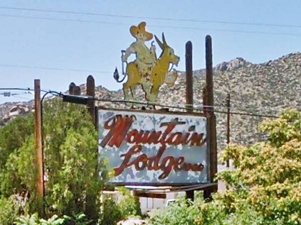
The historic Old Mountain Lodge on the old Route 66 in Carnuel was burned to the ground by a fire on December 18, 2014. Below is its neon sign that same year, before the fire:
The sign of the old Mountain Lodge Hotel before the 2014 fire
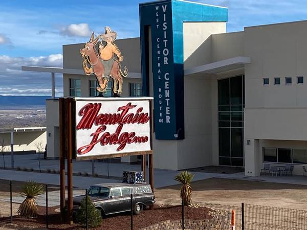
In 2020, Mountain Lodge's owner, Owen St. Germain donated the neon sign that stood beside the burned motel, for the Route 66 Visitor's Center in Albuquerque. It has been repainted and now stands by the new Center on the western side of Albuquerque, as pictured below:
The old Mountain Lodge neon sign in its new home: West Central Route 66 Visitor Center at Nine Mile Hill
This is a Street View of the Motel prior to its destruction.
C. B. Saunders opened it in the 1950s. A contemporary post card described it as follows:

Mountain Lodge Motel, Carnuel. Source. Click for current St. view
In the foothills of the beautiful Sandias on Highway 66 in Tijeras Canyon, 12 miles east of Albuquerque, New Mexico AAA Recommended
On scenic Highway 66 - in a quiet secluded mountain environment.
Eight centrally steam heated, fully carpeted units. Closed warm garages. Elevation 6200 feet. Close to ski area and timber line.
Mr. and Mrs. C.B. Saunders Owners - Managers Telephone Albuquerque - Linda Vista 2
"Then and Now" on Route 66 in Carnuel
This spot is 300 yards west of the Mountain Lodge, to your right:
Route 66 Carnuel a vintage photo
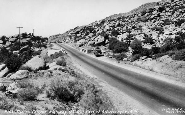
The image below shows exactly the same spot, on the westbound lanes of Route 66 in Carnuel. The bridge crosses a dry gully and the rocks on the hillside can be identified (click on the image to enlarge it, the red box marks the same stones).

Same Rocks by Route 66 in the 1940s and now, St. View
Click image to enlarge
Glacier Boulder
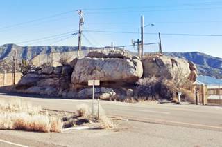
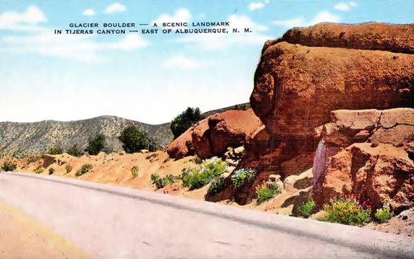
Just 500 ft west, to your left, at Dubb-L-EE Construction is an enormous boulder on the south side of the eastbound lanes, the "Glacier Boulder". Despite being less famous than "Elephant Rock", it had its postcard that read: "A Landmark of Beauty is this giant boulder which dominates the greandeur of the many scenic spots in Tijeras Canyon... Possibly millions of years old, this boulder rests among other prehistoric volcanic formations on U.S. Highway 66..." Below is a 1940s postcard, compare it with the current picture above; The area is built up but the rock is still there.
Webb Trading Post
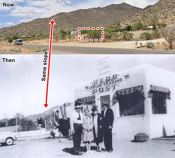
Just one-quarter mile ahead, to your right, on the NW corner of Route 66 with Isidro Garcia Rd. once stood the trading post ran by Carl "Spider" Webb. On on the north side of Route 66 in the Echo Canyon district of Carnuel. You can see it in this 1951 aerial photo. The was an entrepreneur who had previously opened a tuberculosis sanatorium in Cedar Crest before moving to Echo Canyon in the 1950s. Below is a "Then and Now" image of the spot, the dashed box marks the spot. The red arrow shows the same hill in the background:
It was around here, looking west towards Albuquerque that the following picture by Jim Wray, taken in 1958 shows how the four-lane highway crossed a hill located where modern I-40 and NM-333 (old Route 66) cross each other at Exit 170.
Looking west along the WB lanes of US66 in 1958
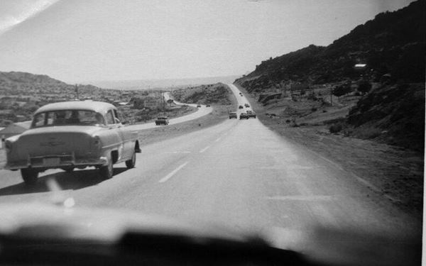
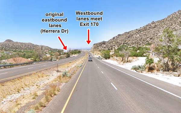
Notice how the original highway (eastbound lanes) on the left, skirted around the hill ahead, while the westbound lanes (right) kept a straight course and climbed it. Nowadays, the old EB lanes run along Herrera Dr SE but are cut by I-40. The WB lanes have cut deeper into the hill, to reduce the grade as they reach Exit 170 as you can see in the following picture:
Looking west along the WB lanes of US66 nowadays
Elephant Rock
Drive west from Webb's post site, for 1.1 miles (map), here the original Route 66 alignment has been disturbed by the construction of I-40 and the interchange at Exit 170. The original highway followed the alignments marked with red and blue lines in our custom map. There is a short surviving segment of the old EB lanes on Herrera Dr. (map and 1951 aerial photo)
To your left on the south side of the highway is the spot where once stood a strange rock formation known as Elephant Rock.
Looking west towards Elephant Rock, vintage photo
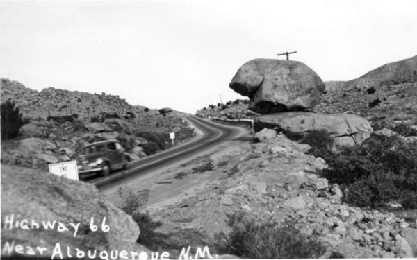
The exact location of Elephant Rock is shown in this Map marking the spot of the Elephant Rock.
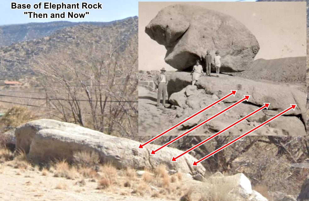
The "rock" was a large boulder set upon another flat rock that served as its base as you can see in the picture (the red arrows mark the same features in both images). It was set close to the shoulder, on the south side of Route 66. The upper rock seemed to balance on the base. It received various names: "Balanced Rock", "Teapot Rock", and "Elephant Rock".
It was the most famous natural landmark of Carnuel Canyon, and people stopped to take photos beside it.
When Route 66 was widened in the 1950s, the "Rock" was considered a nuisance or a danger for large sized vehicles, so it was toppled over. It lies beside its pedestal (that survived) and is resting tumbled on the south side of the road close to its base.
Below are two "Then and Now" images showing the same spot (we added a white square to the 2023 view, marking the position of the rock on top of the pedestal), the red arrows mark the same landscape features. Click on images to enlarge them:

1940s Elephant Rock, US 66 Carnuel Source
Click to enlarge

1940s Elephant Rock, US 66 Carnuel St. view
Click to enlarge
The Village of Carnuel
The village itself is tiny and spread along I-40 and Route 66 (NM-333) in Tijeras Canyon. The area is dry, with a "savannah-like" vegetation: with trees, shrubs and plenty of rocks and ridges. IT has one historic landmark the historic Santo Niño - "Holy Child Parish Church".

Santo Niño - Holy Child Church, Carnuel. Source. Click for street view
Santo Niño Mission Church
Just 0.3 mi. south of Route 66, Map
After its resettlement in the 1880s, two chapels were built in Carnuel in the 1890s. One of them was the family chapel built by Domingo García, it housed the village's patron saint, San Miguel - Saint Michael. This church was demolished in the 1960s.
The second church was erected in 1898 and was built on land donated by Petra and Roman Herrera on the southwestern part of the village. It was also torn down in 1960 and the original stone and adobe building was replaced by the present one, which is larger. On the Saint's day, the town celebrates the San Miguel Fiesta (September 29).
There is a large white cross (st. view) on the hill that is on the northern side of I-40 in front of the church, and there is a "Triumph of the Cross" fiesta on May 3, held together with the Santo Niño festivity.
Aluminum Yucca

Aluminum Yucca, Carnuel. Source. Click for St. view
This is the final and most modern attraction in Carnuel before you reach Albuquerque city limits. It is 22 feet high and 15 feet wide and made with F-16 jet fighters' aluminum fuel tanks. These were cut in half to resemble the scoop shaped yucca leaves. Solar energy powers lights that illuminate it at night.
It is the work of Gordon Huether and a celebration to "20th Century Western Road Culture" that decorated highways with oversized wacky sights.
Continue your Road Trip
Your Route 66 itinerary through Carnuel ends here. You can continue your Route 66 road trip by heading west into the next town, Albuquerque NM.
List of all Route 66 Attractions in Albuquerque East to West:
Check out our pages that cover the sights and attractions in Albuquerque:
- Albuquerque Top 5 Things to See and Do & city overview
- Page 1 Eastern Albuquerque
- Page 2 Nob Hill
- Page 3 Downtown
- Page 4 Colonial Town & Western Albuquerque
- Page 5 4th St. Route 66 - 1926-37 Sights
Sponsored Content

>> Book your Hotel in Albuquerque

Credits
Banner image: Hackberry General Store, Hackberry, Arizona by Perla Eichenblat
Jack DeVere Rittenhouse, (1946). A Guide Book to Highway 66.


