Route 66 in Laguna NM
Index to this page
About Laguna, New Mexico
Facts, Trivia and useful information
Elevation: 5,807 ft (1,770 m). Population: 508 (2025).
Time zone: Mountain (MST): UTC minus 7 hours. Summer (DST) MDT (UTC-6).
The town of Laguna (pronounced "Lah-goon-ah") and Laguna Pueblo are in Cibola County New Mexico and form part of the Laguna Reservation.
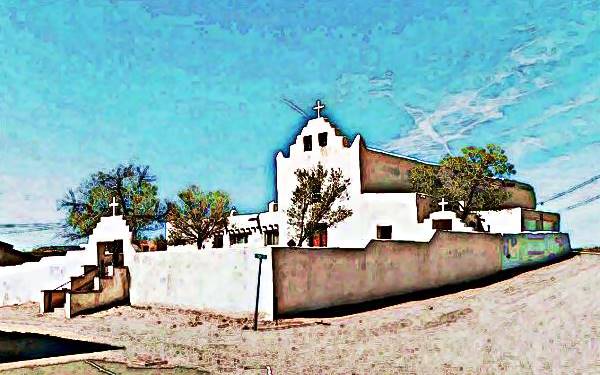
View of the old St. Joseph Mission Church, Laguna Pueblo
History
The archaeological site of Sandia Cave indicates that this part of New Mexico has been inhabited for over ten thousand years. In more recent prehistoric times, the Native American Pueblo people have lived in the valleys of the rivers that flow from the Rocky Mountains into the Rio Grande Basin such as the San Jose River. They used the water to irrigate their crops of maize, squash, bell peppers, and beans.
The native Navajo name of the town is "Tó Láni" which means "Much Water". They name themselves as Ka'waika or Kawaik people.
The Keresan natives lived in Mesa Verde, in the southwest of Colorado, but a dry period (the Great Drought) forced them to migrate south around 1300 AD. They settled along the San Jose River and at Puagana on the south shore of the now desiccated Laguna Lake. They gradually occupied the area of Old Laguna. The Keresan people also settled in the hilltop of Acoma mesa, close to Laguna, south of the river.
The name: Laguna
"Laguna" is a Spanish word that means Lagoon, lake or pond, and refers to the lake, a man-made reservoir now mostly dry that was located close to the Pueblo.
Rio San Jose River
The original name was "Arroyo del Rito" (Brook of the Spring), and also Rio Cubero (after the Spanish Governor, Cubero in the 1690s).
Later it adopted the name San José (St. Joseph), probably due to the image of that saint that the King of Spain gave to the Acoma Pueblo people in 1629. Interestingly, in those days the nearby village of San Fidel was named San José.
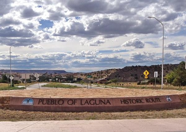
Modern roundabout, the eastern entrance to Laguna on the old US66
The first Europeans to visit this region were the Spanish of Francisco Vásquez de Coronado's expedition in 1540. They visited the nearby Acoma Pueblo. Later, when they finally annexed the area to their American Colonies in 1598, they conquered the Pueblo people by force and established missions to convert them to Catholicism. The Pueblo people expelled the Spaniards in 1680 (Pueblo Revolt), but they were reconquered again when the Spaniards returned in 1692.
After subduing the native uprising, Governor Cubero settled the refugees of the Kwaik people and some others from the pueblos of Cochiti, Zia, Cienaguilla and Santo Domingo. He built the new Laguna Pueblo in 1699 on the remains of an ancient Native village. He named it San Jose de la Laguna. (St. Joseph of the Lake), and this was shortened to "Laguna" over the years. He chose a spot on the sandstone buff on the north side of the San Jose River. It is therefore one of the newest pueblos in the state.
The Nuevo Mexico territory passed on to Mexico in 1821 when the Spanish former colony won its independence from Spain, but in 1848 it became a U.S. Territory when Mexico ceded it after its defeat in the Mexican - American War (1846-48).
In the 1880s the Atchison, Topeka and Santa Fe Railroad reached the area and extended its tracks from Albuquerque towards Gallup. And it built the Laguna station on the south side of town square next to the river. Later, the Navajo tribe had it moved one mile north of the Indian Pueblo.
Rail access brought tourists interested in the Native cultures of the Southwest.
In 1926, Route 66 was aligned along the old dirt trail that linked Gallup, Grants and Laguna with Los Lunas and Albuquerque. It remained on the Mother Road's alignment and even today the old US 66 can be driven through the town. There have been some realignments of the highway over the years (more below in the maps section.) Interstate 40 was built just to the south of the River and you can access the town from its Exit 114.

Where to Stay: Hotels near Laguna
There are no accommodation options in Laguna, but neighboring Albuquerque has many lodging places for those driving along Route 66, you can book a hotel or motel in that town, or in Acoma Pueblo:
>> Book your Hotel in neighboring Albuquerque or Acoma Pueblo
More Lodging Near Laguna along Route 66
Below you will find a list of some of the towns along Route 66 in New Mexico. Click on any of the links to find your hotel, motel or accommodation in these towns (listed from east to west):
On Route 66's Main alignment
The Santa Fe Route 66 segment
Eastwards
Westwards
>> There are RV campgrounds near Laguna (at Acomita)
The weather in Laguna
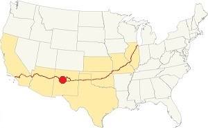
Location of Laguna on Route 66
Laguna has a sunny and dry climate. The winters are cold and summers hot. There are 278 sunny days and 53 days with precipitation per year. The average high temperature in summer (Jul) is 89°F (31.7°C), and the average summer low is around 56.3°F (13.5°C).
In winter (Jan) the average high is about 47.4°F (8.6°C); the average low is well below freezing: 17°F (-8.3°C).
Rainfall is 10.5 inches (292 mm) per year on average and most rain (6 in. - 152 mm) falls from July to the end of Oct. during the "Monsoon" period. Snowfall averages 18 inches and falls between November and March.
Tornado risk
The tornado risk in Laguna is nil: Cibola County has no Tornado watches. The area west of this point has no tornado events at all.
Tornado Risk: read more about Tornado Risk along Route66.
Map U.S. 66 in Laguna New Mexico
Read the Detailed Description of this segment (Albuquerque to Lupton). Below is the interactive map:
>> Custom map of Route 66 in Laguna.
Maps of Route 66
1926 to 32 alignment
Came from Mesita along a winding course following the San Jose River, and curved sharplyt around the dangerous Dead Man's Curve (see this Map marking the spot).
1932 to 1985 Route 66
Due to the dangers of Dead Man's Curve, a new straighter alignment was built in 1932. It was described by Rittenhouse in 1946 and you can see it in this 1951 aerial photo), we marked it with a yellow line in our custom map. It runs in a staight line from Owl Rock to Laguna.
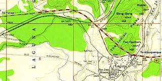
This is the older 1926-32 alignment map with the road from Mesita into Laguna including Owl Rock and Dead Man's Curve. Both alignments meet at Laguna next to Exit 114.
In Laguna
The first Route 66 alignment in 1926 crossed the San Jose river on a timber bridge, 100 yards south of the current one. It headed west for 100 yards and then turned sharply south, following the original railroad bed around the souther side of the village of Laguna. Then it ran northwards past the cemetery and with a NW course to meet its current alignment. This is marked with a green line in our custom map.
By the late 1920s, the traffic along the highway disturbed the ceremonies, endangered villagers and the dust and noise were unbearable so the Pueblo's authorities petitioned to move the highway out of the village. And it was moved.
The 1929-55 alignment curved to the south around the Indian Peaks flanking the hill west of Laguna (map) and then continued along a now eliminated roadbed on the eastern side of NM 124, as marked with a pink line in our custom map.
This roadway was straightened out in the mid '50s by the new four-lane highway that cut straight across them with a SE-NW course (map).
Route 66 Alignment near Laguna
With maps and full information of the old roadway.
- Lupton to Winslow (next)
- Albuquerque to Lupton (Laguna's)
- Santa Rosa to Albuquerque (previous)
The Santa Fe Loop (1926 - 1937)
Our Santa Fe Loop page describes the complete 1926 to 1937 alignment of Route 66 from Santa Rosa to Albuquerque through Pecos, Santa Fe and Bernalillo.
Laguna; Historic Pueblo: its Attractions
Landmarks, Route 66 sights
Historic Context
Jack Rittenhouse wrote his Guidebook to U.S. Highway 66 when he drove along it from Chicago to Los Angeles. He mentions Laguna:
LAGUNA... gas, grocery; no cabins or other accommodations... The store at the crossroads is quite a supply center for the Indians. Rittenhouse (1946)
He described the Mission, village and its history. Rittenhouse mentioned a gas station on the right side of the higway 2 miles east of Laguna (gone when I-40 was built), and westwards he mentions the village of New Laguna, three miles away:
Leaving Laguna, the road makes a short winding climb, and soon comes to a small cluster of homes (L) which comprises NEW LAGUNA... Gas station here. Rittenhouse (1946)
Your Route 66 Road Trip: Laguna leg
Drive west from Mesita into Laguna along the "Dead Mans Curve" (1926 to 1932 alignment). Soon it was clear that the 270° curve at the mesa east of Laguna was dangerous so in 1932 the NM DOT built a shortcut across the plateau from Owl Rock in Mesita to Laguna. I-40 runs along this same course and eliminated the old two-lane route 66.
The cut across the mesa

The cut or overbreak in the mesa east of Laguna, 1932 and today. Source. St. view. A. Whittall. Click to enlarge
The image -click on it to enlarge it- shows the excavation to cut across the plateau. In the distance the arrows left and right mark the same cliffs, and the central arrow shows the famous Owl Rock.
The highway followed the course marked with a yellow line in our custom map into Laguna. Later in the 1950s it was upgraded to four lanes and in the 1970s I-40 was built over it.
The highway reaches the San Jose river, now spanned by two bridges built in 1955 for the 4-lane Route 66 alignment. The first bridge, pictured below was a wooden bridge located 100 yards of the current one, and it entered the village along Marmon Rd., and then curved around it following the old railroad bed of the first railway alignment in the area (green line in our custom map), the traffic along a dusty road was dangerous, noisy and distrubed the locals so the Pueblo leaders negotiated with the authorities to move the highway out of the village and it was realigned along its northern side.
1930s San Jose river bridge at Laguna Pueblo
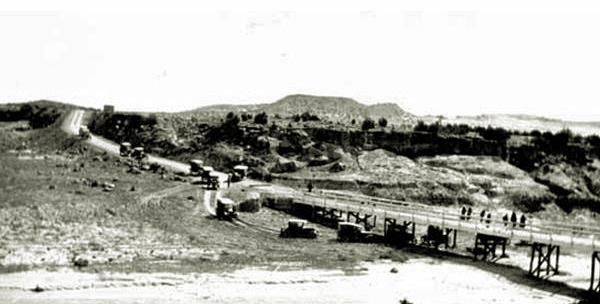
The 1930s alignment crossed the river using a new timber bridge located where the modern ones are placed.
Abraham's Conoco ❌

San Jose US66 bridge site of Abraham's conoco 1932 and today. Source. St. view. A. Whittall. Click to enlarge
On the south side of the higway, on the western bank of the river was Seigfried Abraham's Conoco station, later the Laguna Mart (gone; we use this symbol to mark buildings that have been torn down ❌).
In 1893, Kenneth and John Gunn opened one of the first trading posts in Laguna opposite the AT & SF water tower on Marmon Rd., and a flour mill on the San Jose river bank. Gunn moved the mill to the trading post after a flood washed it away. It was located on the old trail that linked Laguna with Los Lunas and Albuquerque, that later became Route 66. When the new bridge was built in 1930, it was roughly 100 yards north of the old one, bypassing the trading post.
Seigfried Abraham quickly saw the opportunity and opened a Conoco gas station and a trading post on the new alighment; it closed when Abraham passed away in 1938. The picture (click on it to enlarge it) shows the Conoco -right- in 1935, and the current view of the same spot. Siegfreid's daughter and her husband Joe Fernandez reopened it in 1945 adding a store, and butcher shop (1). Both the Mart with its Standard gas station and the Conoco are pictured below:
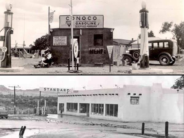
On the corner, the Rio San Jose Rd. extended to the left along the river's west bank towards the historic village church and plaza, and to right to Seboyeta. It was the first alignment of the A.T. & S. F. railroad across Laguna. Route's first alignment followed it (left) into the village. You can drive along this first alignment to reach the church that is half a mile away (map with directions).
The People, the Reservation
The Laguna Pueblo is the largest of the Keresan-speaking Pueblo people; with around 8,000 members. The reservation consists of 500,000 acres of land spanning the counties of Sandoval, Valencia, Bernalillo, and Cibola.
Important rules of etiquette during your visit to a Pueblo
Pueblos are on tribal lands and the local customs, religion, and traditions must be respected.
- Check that access is allowed (leaders may restrict access for private ceremonies) and be prepared to pay an access fee
- Photography. Taking photos may be totally prohibited or a permit may be required. Check with the Tribal Office. Even if you have a permit, always request permission before taking a photo of a tribal member. Leave your cell phone out of sight and silence it, as it could be confiscated
- Don't litter. Don't carry or use alcohol or drugs
- "Off Limits" signs must be respected. Don't remove artifacts or pottery shards
- Don't speed. Respect traffic signs
- Respect the local people. Dances are not a show, they are a ceremony. Show respect and remain silent at all ceremonies
- Cemeteries, Kivas, ceremonial rooms are sacred places and entry is not allowed for non-Pueblo people.
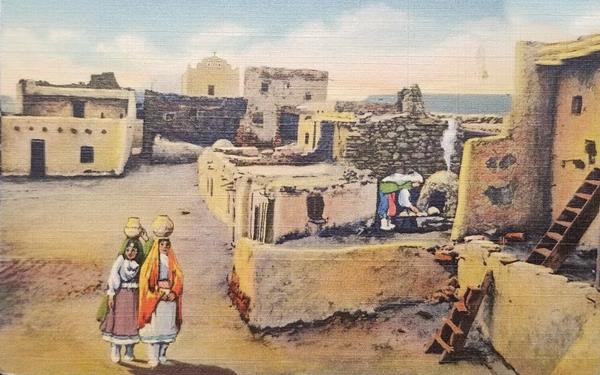
The postcard above reads: "Plaza and Old Church Laguna Indian Pueblo - Laguna is one of the very picturesque Indian Villages on Highay 66 -the Ocean to Ocean route... The women make pottery of a very attractive design."
Laguna Pueblo
Route 66, Laguna Pueblo, NM.
Listed in the National Register of Historic Places
The adobe pueblo with its old church was built in 1699. It is a historic and traditional Spanish colonial Pueblo village.
The pueblo spans 108 acres (44 ha.) and has many adobe homes which are private.
Its southeastern section was part of the original Pre-Columbian native town from the 1400s. It is located strategically on a hill, with its southern flank protected by the San Jose river, the lake that gave it its name was to the southwest, and was a reservoir used to irrigate the crops in the fertile fields along the river.
View of Laguna Pueblo from the south. The arrow marks the Ancient Mission Church.
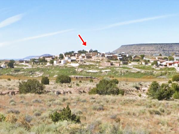
Saint Joseph Church

The altar of Laguna San Jose Mission Church. Source. Click to enlarge
San Jose Mission Church
Listed in the National Register of Historic Places
1 Friar Rd., Laguna Pueblo, NM. The whitewashed San Jose Mission Church was erected in 1701. It is the tallest building of the pueblo and is the center of the religious festivities of the village.
September 19th is the "Fiesta de San Jose", the "Saint Joseph festivity" with dancing and stalls that sell arts and crafts in the square beside the church.
The church is open: 9:00 AM to 3:00 PM. Mon.- Fri. Remember it is a place of worship.
It was built with stone and adobe mortar instead of mud or adobe bricks. It is 105 feet long and its inner width is 22 feet. (32 by 6.7 m)
When the Franciscans left Mexico after the Secularization Laws of 1820 it fell into disrepair for over one century. Father Agnellus Lammert found it standing but without a roof in 1932 and he rebuilt it. It is one of the best preserved buildings of its kind in the U.S. and has many of the original 300-year-old stuctures and artifacts in place (2).
Route 66 and the Pueblos: Trivia
After the 1937 realignment of Route 66, the pueblos at Pecos, Santo Domingo, Sandia, and Isleta were bypassed and Laguna remained as the only Pueblo that could be driven past and was visible from the highway.
The Lake that gave Laguna its Name

1846 map of the Albuquerque to Cubero region of NM. Source. Click to enlarge
The map published in 1846 -click on it to see a large version- shows the region of the Puerco, Grande and San Jose rivers near Albuquerque, with several settlements: Bernalillo, Isleta, Los Lunas, Acoma, Cubero, and Laguna on the left side of the image with the lake just west of it. Laguna got its name from this man-made reservoir that held geese, duck, and other waterfowl dating back to the pre-Hispanic period (late 1300s).
When Antonio Espejo's Expedition reached Laguna in 1583, the site was by "a large lake, into which a
small river flows, which has its origin along the route to Zuni” (una laguna grande donde Entra un Rio pequeño que naze En el camino de suny), during their journey they encountered "many irrigated fields for planting, with their ditches and dams, built as Spaniards would have" (hallamos munchas sementeras de maiz De rriego Con sus açequias y presas Como si esPañoLes lo hiçieran).
In 1812 Pedro Pino explored the area and wrote about the lake: " that gives its name to the pueblo in its proximity [Laguna]. It has a circumference of 2,000 varas. Its sweetwater arises from a large, flowing spring 8 leagues away, and from other smaller
ones. All together, they join to form that very deep reservoir [tanque] of which the residents avail themselves to irrigate a large part of their fields."
The words tanque and laguna are used for the reservoir, but tanque, that derives from "estanque" is a man-made reservoir for irrigation, where a stream is blocked by a dam (3)
The ancient lake has gone, now it is a wetland on the San Jose river, next to the town, to the west close to New Laguna; a temporary lake which forms when the San Jose River floods.
West along Route 66
Head back to the highway next to the bridge. There are two alignments west of this point:
- The 1929-55 alignment. It curved around the south slope of the Indian Peaks just west of Laguna as shown in this map, then continued along a now eliminated roadbed on the eastern side of NM 124, as shown in our custom map with a pink line.
- 1955-70s alignment. The old roadway was straightened out in the mid '50s by the new four-lane highway that cut straight across the hills with a SE-NW course, as shown in this map.
Both of these alignmets crossed the A.T. & S.F. railroad tracks north of Laguna. The original 1926-29 road had a grade crossing. An overpass was built on the 1932 road (see picture) and in 1955 it was torn down when a new overpass was built just west of it to carry the new highway.
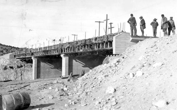
West of this point the highway became a two-lane road and headed west towards New Laguna.
A Side Trip to Seboyeta
14 miles north of the overpass along NM-279. Map and Directions
Seboyeta was the first village founded west of the Rio Grande in 1800. The founding families marched west from Albuquerque to the "Cebolleta" land grant, named after the canyon on the southeastern slope of Mount Taylor (Sierra de San Mateo). Cebolleta is a wild onion.
There you can visit the Church of Nuestra Señora de Los Dolores (Our Lady of Sorrows) built in 1829 and the cave and spring at Portales where there is a shrine of Our Lady of Lourdes.
New Laguna
Head west from the overpass. After 1.8 mi. you will reach New Laguna (map with directions).
The original railroad tracks through the Old Mission of Laguna were moved in 1912 when Santa Fe took advantage of a more favorable grade to the north and bypassed Laguna. The company moved the depot from Old Laguna to New Laguna. A hotel, boarding house, and restaurant popped up by the depot. The building in the 1943 photograph below is still standing, in ruins as you can see in the "Then and Now" images, red arrow; click to enlarge them.

Ruins of a building in New Laguna, NM. St view. Click to enlarge
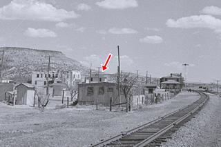
1943 view, Depot and buildings in New Laguna, NM. Source. Click to enlarge
New Laguna gas station
On the highway, another source of revenue for the locals, was the gas station mentioned by Rittenhouse in 1946. It is still standing, the service bay has been walled in, but it has a icebox shape typical of the 1940s. You can see it in this aerial photo taken in 1951.
Marker and Scenic Viewpoint on I-40
For those driving along the freeway, you can stop at the Scenic Viewpoint, a rest aera just west of Laguna's Exit 114, in the spot shown in this map, it offers a view of the Old Laguna Pueblo and there is a marker on its western tip, that reads: "Pueblo of Laguna. Keresan speaking refugees from Santo Domingo, Acoma, Cochiti, and other pueblos founded Laguna after the Pueblo Revolt of 1680 and the Spanish reconquest of 1692. Named by the Spaniards for a marshy lake to the west, the pueblo still occupies its original hilltop site today."
Whether here at the marker or at New Laguna, this is the end of this leg of your Road Trip through Old Laguna.
Continue your Road Trip
Your Route 66 itinerary continues by heading west into the next town, Paraje NM.
Sponsored Content

>> Book your Hotel in Albuquerque

Credits
Banner image: Hackberry General Store, Hackberry, Arizona by Perla Eichenblat
Jack DeVere Rittenhouse, (1946). A Guide Book to Highway 66.
Route 66 & Native Americans; Parametrix, Shawn Kelley and Kristen Reynolds, NM DOT.
Marmon, L., Corbett, T. (2015). Laguna Pueblo: A Photographic History. United States: University of New Mexico Press
San Jose de la Laguna: A History of the Church at Laguna Pueblo, Suzanne Hammons. April 9, 2014. The Voice of the Southwest
Laguna Pueblo History Revisited. Richard Flint. New Mexico Historical Review. Volume 90, Number 1, Winter 2015


