Route 66 in Chenoa IL
Index to this page
About Chenoa Illinois
Facts, Information and trivia
Elevation: 705 ft (215 m). Population 1,697 (20240).
Time zone: Central (CST): UTC minus 6 hours. Summer (DST) CDT (UTC-5).
Chenoa is a town in Central Illinois, in northern McLean County; that has two U.S. Highway 66 alignments crossing it.
History of Chenoa
Illinois was first peopled when the ice sheets retreated some 11,000 years ago. More recently, during the historic period when French explorers reached Illinois in the 1600s, they encounterd Kickapoo natives.
The region passed from France to Britan in the mid 1700s, and after the American independence it became a part of the U.S. that was organized as a territory and later, in 1818, admitted as the state of Illinois.
The first settlers chose the rivers and not the prairies, so the land remained in the hands of the natives until the Kickapoo Indians were forcibly removed in 1832 by the US government and resettled in Missouri. Eventually they'd end up in Kansas.
McLean County was established in 1830. It was named after John McLean a pioneer lawyer, territorial judge, Representative in Congress from Illinois and then US Senator for Illinois.
The first pioneer in what would become Chenoa was Eli Myer who settled in the forest north of Chenoa in 1850.
The Chicago & Alton Railroad laid its tracks through the area in 1854, and it was known simply as "Peoria Junction" during its first days as a railroad depot because two lines converged here. It was named "Chenowa" (with a "W") by M. T. Scott who had purchased the land to plat a city here knowing the tracks would pass through them.
The Name: Chenoa
Scott, a native Kentuckian chose "Chenowa" because it was the Indian name for Kentucky, meaning "dark and bloody ground". However the government office removed the "W" and named the post office "Chenoa". Despite Scott's protests, it remained so until this day.
The township was created in 1858 and soon, mainly due to Scott's efforts, it became a flourishing farming community. State Higway 4 was paved through Chenoa in the 1920s, following the "Pontiac Trail" which preceded it as a decent surfaced road that linked Chicago with St. Louis. When Route 66 was created in 1926 its first alignment followed State Hwy. 4 and ran through the business district in Chenoa, meeting US 24 there.
In 1943-44 a bypass with 4-lanes was planned and built, west of the business district to make the highway safer and faster, it was finished in 1954, but shortly after, in 1958, the new I-55 bypassed it too. Route 66 was decertified in 1977.

Lodging and Accommodation in Chenoa
There is accommodation in Chenoa:
> > Book your hotel in Chenoa
More Accommodation near Chenoa on Route 66
Below you will find a list of some of the towns along Route 66 east and west of this town; click on any of the links to find your accommodation in these towns (shown from east to west):
Along Route 66 in IL
- Hotels in Illinois
- Route 66 Starting point ▸ Chicago
- Lockport
- Willowbrook
- Bolingbrook
- Plainfield
- Romeoville
- Joliet
- Wilmington
- Dwight
- Pontiac
- Chenoa
- Normal
- Bloomington
- Atlanta
- Lincoln
- Springfield
- Raymond
- Litchfield
- Staunton
- Williamson
- Hamel
- Edwardsville
- Collinsville
- Troy
- Glen Carbon
- Pontoon Beach
- Granite City
- East St. Louis
West in Missouri
- Hotels in Missouri
- Florissant MO
- Bridgeton MO
- St. Louis MO
- Kirkwood MO
>> See the RV campground in neighboring Pontiac
The Weather in Chenoa
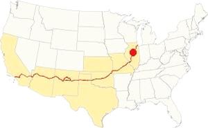
Location of Chenoa on U.S. Hwy. 66
The climate in Chenoa is a "Humid Continental" one, so it has very humid and hot summers and cold winters.
Its average temperatures are the following: during summer (Jul) the high is 85°F (29.7°C) while the low is 63°F (17.2°C). During winter (Jan) the avg. lows are a freezing 17°F (-8.3 deg;C) while the high is a chilly 30°F (-1 °C).
Rainfall is around 38 in. (965 mm) per year, and the sunny days are, on average 194 days per year.
Snowfall is 26 inches (66 cm) each year and falls from Nov to the first days of Apr.
Tornado risk
Chenoa's area is hit by about 7 tornados per year.
Tornado Risk: read more about Tornado Risk on US 66.
Map of Route 66 through Chenoa, Illinois
Route Alignment
>> Custom map with the alignments of US66 in Chenoa.
The first highway in this region was a dirt surfaced stagecoach route that linked the area with the state capital in Springfield. The road was improved in the early 1900s when cars started to become popular. By 1915 the old trail had been improved and was known as the Pontiac Trail. This road was paved by 1923 and it linked Chicago with St. Louis MO, it was also designated as Illinois State Highway 4. In 1926 Route 66 was aligned along it.
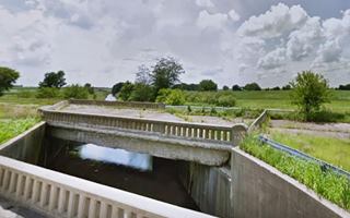
The segment into Chenoa coming from Ocoya is flanked by an abandoned set of lanes belonging to the 1940s-77 four-lane alignment. The highway passes by the historic 1940 bridge (pictured) and reaches the north side of Chenoa. Where there is a fork in the alignments.
1926-44 Road
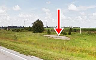
This was the IL Hwy 4 alignment and is shown with a pale blue line in our custom map. It went into Chenoa along Morehead St. and then continued south along a now abandoned segment shown with a purple line in our custom map. Its southern tip is pictured above.
1944-77 Bypass Alignment
The original 1920s road was narrow and had lanes 9 feet wide; it was 6-inches thick. It was damaged by the heavy truck traffic during WWII so it had to be urgently improved.
In 1943-44 a bypass with 4-lanes was planned and built, west of the Chenoa's business district to make the highway safer and faster: two lanes of 10 inch deep concrete, 24 feet wide were built on top of the old roadbed (southbound lanes) and the second set of lanes, northbound were completed in 1954-55.
You can see the now abandoned southbound lanes both north and south of Chenoa, to the west of the current highway. Further north and south, these lanes are buried beneath the northbound lanes of I-55.
Route 66 is a Historic highway and has also been designated as a National Scenic Byway and an All-American Road in the state of Illinois.
Visit our pages with old maps and plenty of information about US 66's alignments in this area:
The Route 66 alignments near Chenoa
- Springfield to Staunton IL (1926-30 US66) south from Springfield (next)
- Springfield to Hamel (after 1930) south from Springfield (next)
- Pontiac to Springfield (Chenoa's)
- Chicago to Pontiac (previous)

Sights and Route 66 Landmarks in Chenoa
What to see in Chenoa
US 66 in Chenoa: historic context
Jack DeVere Rittenhouse drove from Chicago to Los Angeles in 1946 and wrote his "A Guide Book to Highway 66" describing his itinerary. In it he also mentions Chenoa:
...Burch & Downe's garage; several cafes and gas stations; few cabins... Town is a few hundred yards (Left) off US 66. Junction here with US 24. Pike HotelPike Hotel in Chenoa Rittenhouse (1946)
It is clear by his description that he drove down the new 1940's bypass alignment.
Not much has survived from the 1930s or 40s in Chenoa, the old Route 66 are mostly gone, torn down or removed. We will describe this leg of our Route 66 Roadtrip through Chenoa from east to west.
Historic Route 66, Cayuga to Chenoa (1943-44 ⁄ 1954-55)
Listed in the National Register of Historic Places
The original Pontiac Trail was paved in the early 1920s and became Illinois State Highway 4. Route 66 was aligned along it in 1926. By WWII it had become inadequate to carry heavy traffic as it was narrow and had a thin roadway. It was upgraded by widening the concrete roadway and then a second set of lanes was added to the alignment. Now only two lanes are maintained and the second set is abandoned, but visible.
The Service Stations north of Chenoa
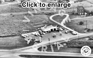
1966 view Chenoa Texaco, US 66. Source. Click image to enlarge
Driving west from Ocoya, as you reach the north side of Chenoa, the first service station was located to your left, on the intersection of Route 66 with N Divison St. on its NE corner. Here was Goodin's Texaco which can be seen in the aerial photograph below, taken in 1966; two service bays, icebox shaped, no canopy. The place is still there; a canopy has been added.
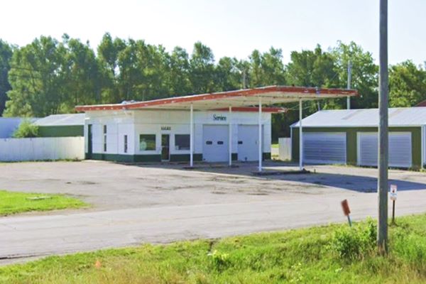
Continue westwards for 0.3 miles to the next crossroads where there were three gas stations. All gone. This was the the intersection of the original 1926-48 alignment into Chenoa (now N Moorhead Dr) with the four-lane '66 that bypassed the town along its western flank.
Ballenger's Standard Station
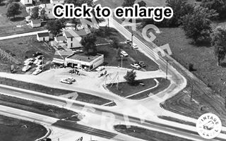
1966 view of Chenoa Standard on US 66. Source. Click image to enlarge
On the western side of the four-lane Route 66, on the SW corner where the veterinary clinic is now located, there was a Standard service station that had been Todd's Standard Service until 1958, when he sold it to Ballenger. George Powell operated it from 1949 to 1976, and was its sole owner after 1962. See the 1966 aerial view of the site.
Conoco and Café
Across the highway, on the NE corner of N Moorhead Dr. was a Conoco (over the years it was also a Gulf and then a Sunoco) with a Cafe in a separate building just north of it that had at one time been "The Galley" restaruant, then a Tastee-Freeze, and later Ken & Pegs Cafe ran by Ken and Peg Sipe,and a Car Wash on its southern side.
It had been owned by Tinges and Marlin Poole was one of its last operators, Poole later moved to the intersection of US 66 and US 24 (next to the Chenoa Motel when I-55 opened. You can see it in the pictured below that looks towards SE with the four-lane Route 66 in the foreground and the original US 66 on the right:
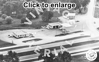
1966 view of the Chenoa Conoco, US 66. Source. Click image to enlarge
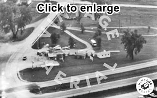
1966 view of Chenoa Sinclair and Cabins on US 66. Source. Click image to enlarge
Sinclair and Cabins
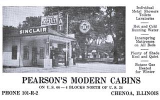
1920s Pearson's Sinclair and Cabins on US 66. Source. Click image to enlarge
Opposite the Conoco, across N Morehead Dr on the SE corner of the intersection there was another gas station, now it is a Dental clinic. It was a Sinclair ran by Mr. Barclay and later a Bandico station ran by Ralph and Lila Wagner. Pictured above looking to the South, the original US 66 runs along the left side of the picture.
First Tourist Cabins (Gone)
They were located here just north of the park (St. view of the site). Joe Watchinski of Bloomington built a gas station and a lunch room here in 1921, on the Illinois State Highway 4 alignment. Lloyd Sarver bought it in 1926 when U.S. 66 was aligned along it. He built the first tourist cabins in 1929: four double cabins and set up outdoor cookers and ovens for camping travelers. During the Great Depression, he sold it to S.B. Stockum (1937) who in turn sold it to Elvin Pearson who modernized the cabins (see picture). The last owner was Ralph Wagner who bought the site in 1953 and still operated the cabins that can be seen in the picture. 1
Along the Original 1926-40s US 66 into Chenoa
Tourist Park
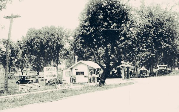
Take a left and drive along the original alignment of Route 66 into Chenoa, along N Moorhead St. To your right is the VFW Park, that houses the Chenoa Redbird Park and Swimming Pool. Also known as The American Legion Park it was presented to the city by Matthew T. Scott in the late 1800s. The gift had been initially rejected because the council considered the place "just more waste land," it was a cow pasture until Route 66 was aligned along it and then it became a tourist park.1 The picture below, taken in 1933 looks towards the NW at the park from U.S. 66; the sign reads "Chenoa's Free Tourist Park."
Gasoline Alley
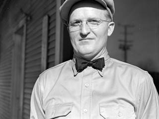
Burt Arnold, 1942, Chenoa. Source.
Click image to enlarge
The highway into Chenoa was known as "Gasoline Alley", there were six gas stations along it during its heyday.
The image shows Burt Arnold, a gas station proprietor, and was taken on Jan 13, 1942 captioned "Chenoa gas station operator interviewed regarding falling sales, 1942", and was part of an article titled "Gas station men on Route 66" published in Pantagraph as an interview feature about the impact of WWII on sales due to the drop in traffic along Route 66 by 25 to 30%.
Ahead, Route 66 crossed the railroad line that forked off here towards Peoria using a grade crossing and entered downtown proper.
Steve's Cafe and Texaco Station
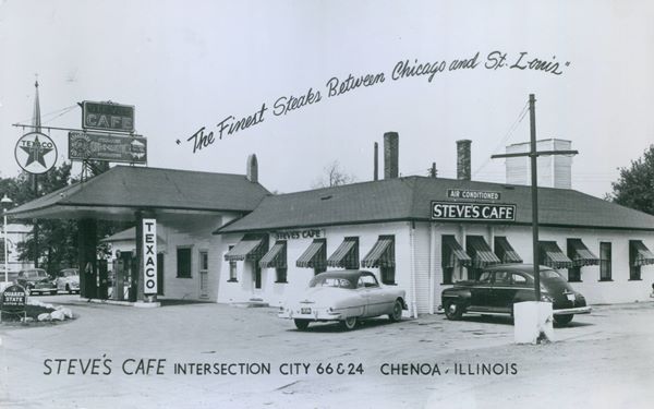
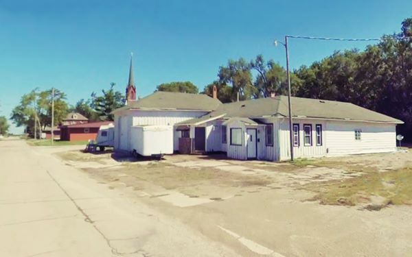
Three blocks after the railroad tracks, to your left at 305 S Moorhead St, with the old hip roofed canopy enclosed as a garage is the former Steve's Cafe and Texaco station. The building is still standing; it was built around 1918 as a restaurant by the Elliot brothers. In 1925 it was ran by the Zirkle brothers. During the Great Depression in 1934, Elmer and Orville Wahl turned it into Wahls Cafe. Their Cheff, Steve Wilcox acquired it in the late 1930s when it became Steve's Cafe. The last owners were Ken and Peg Stipe who bought it in 1975 and renamed it the Red Bird Lounge. It closed for good in 1997.
Its 1940s postcard promoted it as having "The Finest Steaks Between Chicago and St. Louis," at the "Intersection City 66 & 24" (notice that City 66 was the original alignment of the highway and the Beltline or Bypass 66 ran around the town). Pictured below in a set of "Then and Now" pictures:
Crossroads with U.S. 24 & Old Alignment
The next blocks had several gas stations, all of them gone: Tinges had a service station and a Pontiac dealership; Birch and Downes mentioned by Rittenhouse evolved into Downes Motor Co. and sold Kaiser-Frazer cars.
At its intersection with U.S. 24 (W Cemetery Ave) to the left was the grade crossing leading into the town's business district. Now it is a "T" junction, but until the late 1980s, the original alignment of Route 66 continued south, parallel to the railroad. Now it is cut off from Cemetery Ave. Below is a view at the junction looking south:
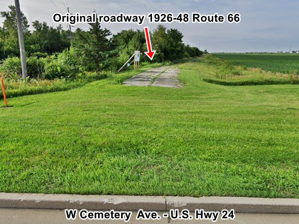
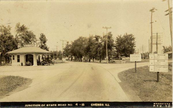
This roadbed, now abandoned runs for almost one mile before meeting the driveable alignment further south. This was also the original alingment of Illinois State Highway 4 paved in the early 1920s. At that time U.S. 24 didn't exist, its roadway was IL Hwy 8. The images below look north from the intersection over the course of the years. Notice how it changed!
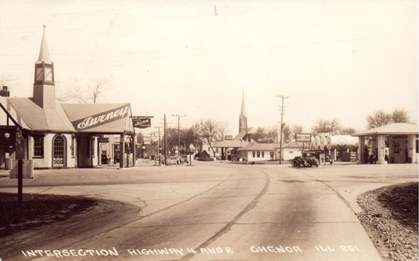
The sign on the right in the image below taken around 1922 shows Hwy 8 running left to right with mileages to El Paso, Peoria, Fairbury and Watseka, and Stae Hwy 4 running top to bottom, the sign reads " 4 - STRAIGHT AHEAD Pontiac 11 Mi Chicago 107 Mi." The gas station with a hip roof integrating canopy and office, with sturdy box pillars has a Sweney Gasoline sign and two pumps with two cars by them. Notice the box-car on the railroad to the right.
In 1922.
Sweeney Cafe and Gasoline is still there in 1937, with a steeple-like projection on its roof, this postcard posted in 1937 still reads Highway 4 and 8 intersection Chenoa (?) instead of U.S. 66 and 24. North of Sweeney's is a Cafe and gas station belonging to Streid. To the right is the cafe where Steve's is located -same hip roofed building and somt Standard Oil and Red Crown exterior gasoline tanks. There is a gas station on the NE coner too.
In 1937.
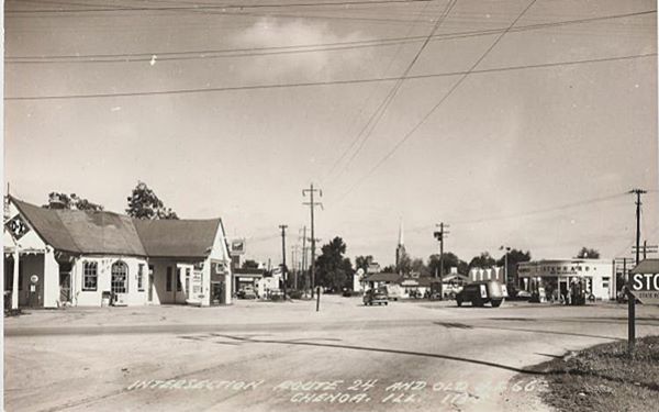
By 1940, we can still see Steve's but Streid's station on the NW corner now sells D-X brand. The one opposite has gone and Tom's Standard Station is visible to the right.
In the 1940s.
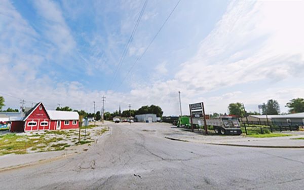
Nowadays, only Steve's has survived.
The same spot in 2023.
Tom's Standard Station (Gone)
Built in the 1930s torn down in the early 2000s, this was a Standard station with a curved tiled facade and two service bays It was located on the eastern side of the highway just north of the intersection. It followed the 1930s Standard Oil Company design prototype: a standard oblong box, with porcelain enamel walls and a large window area onthe office, plus multipane bay doors. A typical Streamlined Moderne gas station design. Pictured below (click images to enlarge).
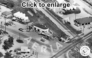
1968 view of Chenoa Standard service at U.S. 66 & 24. Source. Click image to enlarge
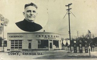
Tom's Standard c.1930s Chenoa Source. Click image to enlarge
Streid's Sweney Cafe and Gas
E. M. Streid operated a service station and a restaurant on the intersection's NW corner. He added cabins in 1931 that were built by the Sweney Gasoline & Oil Co. on the rear of their property at the crossroads.1
Sweney began as the Bartles-Sweney Oil Co. and sold gasoline plus "Be-Esco Oils and Greases" it was founded around 1903 by Joseph Bartless in Peoria Illinois, and Waterloo Iowa, and later sold it to Guy Sweney. The company was an independent operator that later it was bought out, and supplied the D-X stations in the region.
Later, Ed Ritter opened a drive in that in 1967 beca e Kat-E-Korner Drive In ran by Bob and Donna Rose (Augspurger) Saffer. They ran it until 1988 when they converted it into Bob’s Kat-e-Korner Dolls and Gifts. Donna ran it until her death in 2021.
Downtown Chenoa - Business District
Before heading west to the Bypass alignment, visit the old business district of Chenoa. Take a right, cross the tracks and turn left along Green St. into Chenoa's downtown.
Selz Royal Blue Shoes Mural (Gone)
Ahead, after crossing Lincoln, to your left on the south-facing wall of the building following the Public Library at 224 Green St. was the now gone Selz Royal Blue Shoes Mural. When the Library was built (2019-2020) the wall was painted brown and the mural was erased (current street view). Below is what it looked like while it still stood:
The company that advertised with these mural sings was Selz, Schwab & Co.. Morris Selz migrated from Württemberg, Germany to Chicago in 1854. He joined Cohn and made clothes but in 1871 he began selling shoes wholesale, founding his M. Selz & Co. he soon grew and built a factory selling around one million dollars a year of shoes and boots. Charles Schwab joined as a partner in 1878.
The company had 1,500 employees producing 12,000 pairs a day in the early 1900s and several factories near Chicago. The Crash of 1929 and the Great Depression hurt sales and the company went bankrupt shortly after.
The now gone Selz Royal Blue Shoes Mural in Chenoa, Illinois
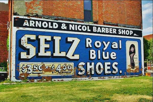
The Selz Royal Blue Shoes Mural was discovered when the building that had covered it was torn down. The sing was then recreated.
Pike Hotel (Gone)
Across from the Library. This hotel mentioned by Rittenhouse burned down on Feb. 16, 1972. Built in 1894 by E. M. Pike, it stood at 211 Green St. The hotel had closed long before but it housed several businesses. It is a parking lot on the eastern side of Green St. The hotel had 35 rooms and in 1936, belonged to Marie Dahl who rented rooms for prices ranging from 75 cents to $2. Back in 1916 its slogan had been "Three meals, room with bath, For two dollars and a half."
Just ahead, to your right, on the same block is the Chenoa Pharmacy:
Chenoa Pharmacy
Illinois Route 66 Hall of Fame
At 209 Green Street, it was established in 1889 as Schuirmans'Drug Store and it has been operating since then. It still has the original wood floor. It can be visited.
Tido "Carl" R. Schuirmann and Henry Hops bought the store from Ruger and Banta in 1888. Hops sold his share in 1909. Carl was a music enthusiast and he organized music lectures and the first orchestra at the Methodist Church. Carl passed away in 1930 and his daugher Emma continued running the store.
Chenoa Pharmacy in Chenoa, Illinois
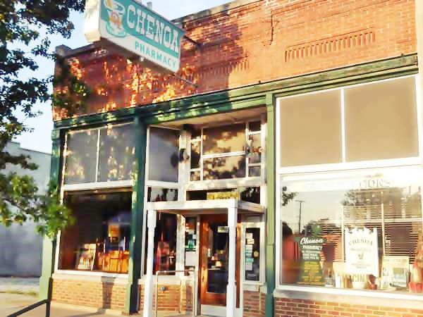
Historic Matthew T. Scott Home
Listed in the National Register of Historic Places
Drive 0.3 mi north along N. Veto St. to visit the historic Home (see this map with directions), it is located on 227 North First St; see this street view.
Built between 1855 and 1863, it belonged to the founder of Chenoa, Matthew T. Scott, who was one of the founders of the Daughters of the American Revolution. Adlai Stevenson I (23rd Vice President of the US from 1893 to 1897) married Letitia Green in this house in 1866.
Matthew Scott (1828 - 1891). Besides from founding Chenoa, he built almost 200 houses, cultivated 16,000 acres, and laid more than 275 miles of hege fence (in the days before barbed wire). He drained land with tile drains and ditches.
This ends your drive through the town od Chenoa. Turn around, retrace your tracks and head back to Cemetery Ave (U.S. 24) turn right and drive west along it towards the four-lane U.S. 66.
"New" U.S. 66 (1940s-77 alignment) and U.S. 24 alignment intersection
Just before you reach the junction mentioned by Rittenhouse in 1946, to your right is the site of the now gone Chenoa Motel and the also razed Marlin Poole's gas station.
Chenoa Motel (Gone)
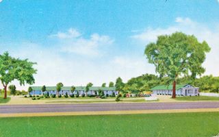
Chenoa Motel postcard. 1957. Source.
Click image to enlarge
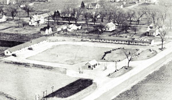
Built in 1948 at a strategic location by the northeast corner of the junction of Bypass 66 and U.S. 24. It had an L-shaped layout and its courtyard was located where the Chenoa Family Restaurant now stands. It belonged to Isaac Weaver and had 8 units and a gas station. He sold it to Ray Anderson in 1950, who added another 8 units in a separate building. It changed hands several times, and was torn down. Below is an aerial photograph of the motel and the gas station with U.S. 24 to the right.
Motel Trivia
There was another motel in Chenoa, it began when Elvin Pearson bought Merrick's gas station on Highway 24 and S 4th Ave where the Heartland Bank is now located, and built some cabins. Moore bought it in 1953 and he built the motel, Moore Rest there (aerial photo from 1966), but it has no connection with Route 66.
Hen House Restaurant
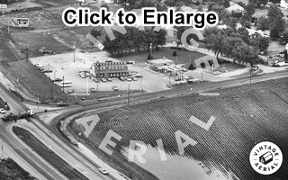
1974 Hen House, Motel and gas station Source. Click image to enlarge
The Hen House restaurant was built right on the NE corner of the intersection. It was designed to look like a barn and was owned by Dunc and Helen Powell. The restaurant was razed and a garage-mechanic shop stands on the north side of the property; the motel and gas station were also torn down and the new Chenoa Family Restaurant occupies the spot where Pool's gas station stood. The image shows the motel (right), gas station (middle) and Hen House (left) and the crossroads lower left.
On the NW corner where the Shell station is now located was was Ken Sipe's "Horne's Restaurant" it was a counter and booth restaurant with a large gift shop. It also sold Mobil gas as you can see in this 1968 aerial photograph.
Deadly Route 66
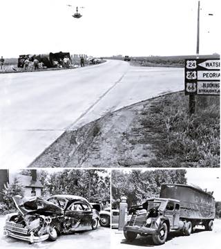
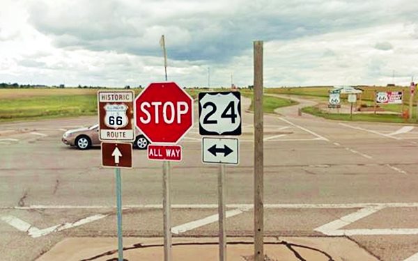
This is the junction with U.S. higway 24, mentioned by Rittenhouse in 1946. It was an important and dangerous crossroads. There were many accidents here over the course of the years.
>> Learn more about The dangerous Route 66 (Bloody 66).
In the image we combined some pictures of a crash at this intersection that took place on July 12, 1949 between a Stetson China Co. truck, of Chicago and a car. Notice the traffic light hanging above the intersection. Click the image to enlarge it.
Nowadays there still is a flashing red light and a stop sign at the crossroads.
Looking south along Route 66 at its junction with US 24 in Chenoa, Illinois
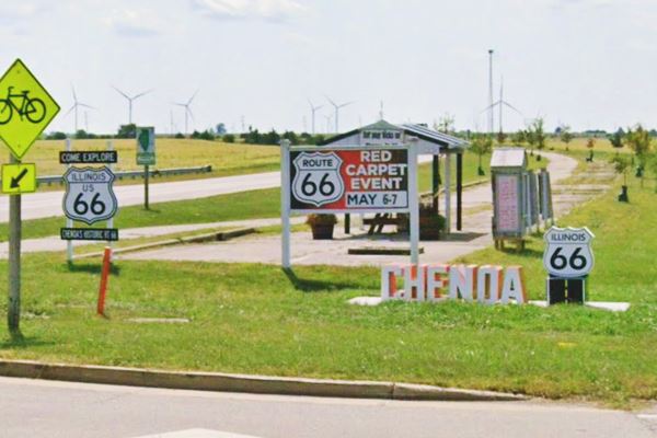
Route 66 Shield and Chenoa Centennial Sign
On the SW corner of the crossroads there are several signs and a gazebo with some exhibit panels with information on Route 66 in Chenoa. They are set on the former westbound lanes of the 4-lane highway. Now there is a bicycle trail along it. A new monument and marker with a Route 66 shield and multicolored letters spelling the word "Chenoa" have been added as part of the 2026 celebration of the Route 66 Centennial (1926-2026). See it in the image below (lower right).
Ballard Grain Elevator (Gone)
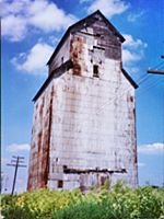
Ballard Grain Elevator in 2000. Source
Drive southwards along Route 66. After 0.8 miles, the highway approaches the railroad to your left, and here is the southern junction of the original '66 with the later Bypass alignment.
Head straight towards Lexington. The Graham and Bennion Elevator also known as the Ballard Grain Elevator was located 3.1 miles south of this point on the SE side of the highway, towards Lexington. It was located in what used to be the small community of Ballard, now a ghost town; on the southeast side of the old road. The elevator was demolished in 2006 (this is the Map showing where it was). It stood 80 feet tall and was built in 1900. Its capacity was 40,000 bushels.
Continue your Route 66 Road Trip
This is where your journey across Chenoa ends, head south into Lexington to continue your US 66 road trip.

Sponsored Content
>> Book your Hotel in Chicago

Credits
Banner image: Hackberry General Store, Hackberry, Arizona by Perla Eichenblat
Jack DeVere Rittenhouse, (1946). A Guide Book to Highway 66.
1. Chenoa Community Centennial A Century of Co-operation 1854-1954.


