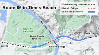
Route 66 crosses the Meramec River
Index to this page

TheRoute-66.com is reader-supported. When you buy through links on our site, we may earn an affiliate commission at no additional cost to you.
About Times Beach Missouri
Facts, Trivia and useful information
Elevation: 456 ft (139 m). Population 0 (2010).
Time zone: Central (CST): UTC minus 6 hours. Summer (DST) CDT (UTC-5).
Times Beach was a town but due to a chemical contamination with dioxin, it was evacuated in 1983, quarantined and later disincorporated. The buildings were razed and the former townsite after being decontaminated became the Route 66 State Park. It is located in St. Louis County, on the 1932-1977 alignment of Route 66 in the central-eastern Missouri.
History of Times Beach
For a detailed history of this region, see our page on the history of neighboring Eureka.
The town was born in 1926 and was a commercial undertaking of the St. Louis Times (that is how it got its name, the "Times" part of it). It sold sections of lots, part of a "New Summer Resort on the Meramec". They cost $67.50 per lot and could be bought at $10 down and a $2.5 monthly installment and the buyer had to also purchase a six month subscription to the newspaper. They were minute lots of 20 by 100 ft (roughly 6 x 30 m).
The low-lying land on the placid Meramec River valley had "A mile of river beach and safe place for the kiddies. Excellent swimming, safe wading for the youngsters, boating and fishing... beaches and wooded parks", which gave the town's name its second part: "Beach".
The Name: Times Beach
The name combined the name of the newspaper that sponsored the promotional land sale "St. Louis Times" and the "Beach" it had along the shore of the Meramec River.
It was located on "good roads" and "little over an hour... from St. Louis". Route 66 did not reach Times Beach at that time; it ran further north, through Manchester, Pond and then to the west in Gray Summit. However it was close to Eureka and the railroad and there was a road linking it with St. Louis.
The area was often flooded -it was on the river's flood plain- so many of the summer homes built there were mounted on stilts. It grew slowly during the Great Depression and in 1932 a new bridge was built across the Meramec (replacing the older 1900 one) and Route 66 was realigned through Times Beach.
During WWII, gasoline rationing made it difficult to commute to the summer bungalows in the area. It survived as a small low-income community with some summer visitors and incorporated in 1954. In 1956 a new bridge was added for the eastbound traffic and later, in the mid 1960s I-44 added a third bridge to carry the westbound lanes, bypassing the town.
Population grew to around 2,000 residents at the time it was contaminated with oil tainted with dioxin.
Contamination with Dioxin
The Northeastern Pharmaceutical and Chemical Co. Inc. (NEPACCO) manufactured thriclorophenol and, as a byproduct generated dioxin, a highly toxic chemical. They hired IPC, another chemical company to dispose it and IPC in turn sold it to Russell Martin Bliss a waste oil company based in Rosati (Route 66 in Missouri).
Dioxins: toxic chemicals
Dioxins are a family of chemicals of which around 30 are significantly toxic. They tend to breakdown slowly in the soil (their chorine atoms prevent bacteria from doing so) and the UV radiation in sunlight degrades them very slowly.
They accumulate in animals' fatty tissue: 90% of human exposure comes from food (meat, dairy products, fish, and shelfish) and once they are inside the body they remain there for a long time: their half-life is around 10 years. This means it takes 10 years to get rid of half of it.
The 1976 dioxin release from a chemical plant in Seveso in Italy affected 37,000 residents and contaminated 5.8 sq.mi. (15 km2).
It produces skin lesions (chloracne), altered liver function, and animals exposed to dioxins developed cancer, so it is classed as a "known human carcinogen". Read more at the World Health Organization website.
The dioxin gets into oil used for dust control
Bliss was unaware of the product's toxicity and he got rid of it by mixing it with used car oil and using it in the dust-suppressant service his company provided: he sprayed the oil on sand or dirt surfaces (like roads and arenas) to keep the dust down.
The town of Times Beach had 16.3 mi. of dusty roads and Bliss was hired by the city to spray the roads during the summer of 1972 and 73. He charged 6¢ per gallon of oil.
But something was amiss; animals started to die and children got ill at one of the arenas so the CDC (Centers for Disease Control) investigated in 1971 and found the cause: dioxin. It reported the case to the Environmental Protection Agency (EPA) in 1975 but due to various reasons action only began in 1982. It was then that Times Beach (that had also been sprayed by Bliss) found out about its contamination. The US government bought the whole town and its residents were evacuated in 1983. The town voted its disolution in April 1985, and was disincorporated by the state of Missouri shortly after.
Its location on a flood plain meant that the dioxin could spread elsewhere so the state placed an incinerator on the former townsite in 1995 to deal with the contaminated soil -50% of the state's dioxin was located there. Over the next two years, at a cost of $200 milion, it burned over 265,000 tons of dioxin tainted material from all over Missouri. It closed in 1997.
The Other Contaminated town on Route 66: Picher Oklahoma
Pitcher, now a ghost town in Ontario County, Oklahoma, was contaminated due to the water loaded with toxic heavy metals that leached from the mine tailings that surrounded this former mining town. When the town was also found to be collapsing due to the mine shafts below it, it was evacuated, declared uninhabitable. It was dis-incorporated in 2009 and the municipality was dissolved in 2013. Read all about this here Picher, near Commerce OK and Route 66.
Aftermath for Times Beach
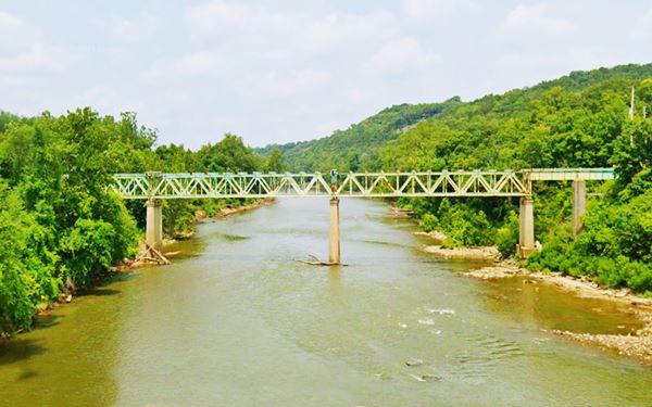
The 1982 decision by the CDC to publicly recommend that the town be evacuated, meant that 800 families were uprooted and relocated elsewhere. Their homes were demolished in 1992. There has been no evidence that low-level dioxin exposure has caused adverse health effects in the former inhabitants of Times Beach.
The EPA tested the oil at the former townsite (now Route 66 State Park) in June 2012 and concluded that "Soil samples from Route 66 State Park show no significant health risks for park visitors or workers". Some have considered that the evacuation had been an overreaction, but the uncertainties at the time led the authorities to play it safe and protect the residents even if it meant relocating them.
Route 66 State Park is created
The townsite after the massive clean up and fully decontaminated was then handed over to to the Missouri Department of Natural Resources' Division of State Parks, and in 1999 it became Route 66 State Park.

Find hotels near Times Beach, Missouri
There is no lodging at the site of old Times Beach & Route 66 State Park, try neighboring Eureka:
> > Book your accommodation in neighboring Eureka
More Lodging near Times Beach along Route 66
There are several hotels in the area close to this town. Alternatively you can also find your accommodation along Route 66 in the neighboring towns and cities in Missouri. We list them below (from east to west):
On Route 66's Main alignment in MO
Eastwards
Westwards
- Hotels in Kansas
- Baxter Springs KS
- Galena KS
- Riverton KS
- Hotels in Oklahoma
- Miami OK
>> Check out the nearby RV campground in Pacific
Weather in Times Beach
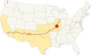
Location of Times Beach on U.S. Hwy. 66
The area where Times Beach stood (now it is Route 66 State Park) has four well marked seasons. It is located in the area where humid continental climate shifts towards a humid subtropical climate, so summers are hot and humid while winters are cold. It gets cold Arctic air and hot damp tropical air from the Gulf of Mexico. Spring is wet and may have extreme weather (tornados, thunderstorms and even winter storms). Fall is sunny and less humid, with mild weather.
The average high in winter (Jan) is a cool 39.9°F (4.4°C) while the average low is a chilly 23.7°F (-4.6°C). The summer (Jul) average high is 89.1°F (31.7°C) and the average low is 71°F (21.7°C).
Rain is on average 41 in. (1.041 mm) with the rainiest months being May through July with over 4.1 in monthly (104 mm). Snow falls between Nov. and Apr., with a total snowfall of 17.8 in. (45 cm). Relative humidity ranges averages 69.7% and is fairly stable year round.
Tornado risk
Route 66 State Park is located in Missouri's "Tornado Alley" and St. Louis County is struck by some 7 tornados every year. Tornado Risk: read more about Tornado Risk along Route66.
Map of Route 66 in Times Beach
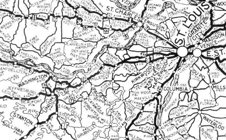
1924 Auto Trails Map. Credits.
Click image to enlarge
The first Route 66 alignment from 1926 to 1932 ran further northy, along the "State Road to Jefferson City." It didn't pass through Times Beach. The small map (click on it to enlarge) shows the "Auto Trails" in this region in 1924, two years before Route 66 was created.
The map below, published in 1931, shows Pacific and Fenton linked by a dashed line marking "Routes not yet constructed" and US 66 further north through Ballwin and Manchester.
Map 1931 showing US66 into St. Louis
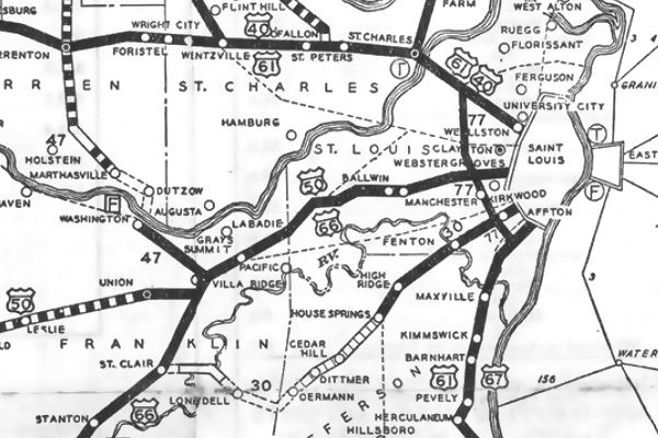
The highway was realigned through Times Beach into St. Louis in 1932.
Map of US66 in Times Beach
The old roadbed can be driven here on the eastern side of the Meramec river towards the historic bridge; it is 0.7 mi long; see it in this map.
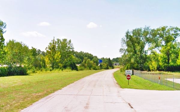
The Meramec River US 66 Bridge is still there, but it lacks its deck. On the western side of the river there is a short segment that can be driven (map), but west of this segment, into Eureka the original road was torn up when the freeway was built over the old alignment. It resurfaces on the north side of the freeway at Exit 264 in Eureka. See image below.
Three and Four Lane Route 66
By the early 1940s Route 66 was congested and the heavy traffic made it unsafe.
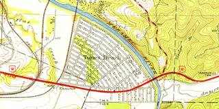
Rittenhouse mentions in 1946: "From here (Gray Summit) into St. Louis, US 66 has three or more lanes." Click 1945 USGS map above for a large size map showing the three and four lane alignment.
The third lane although designated in one direction, was known as the "death lane" due to the head-on crashes caused by those who didn't follow the rules. It was upgraded to a new four-lane divided dual carriageway highway which replaced the old US 66 in the mid 1950s.
The Route 66 alignment in Times Beach
Visit our pages with old maps and plenty of information about US 66's alignments.
- Gray Summit to Rolla (next)
- Route 66 St. Louis to Gray Summit (In Times Beach)
- Route 66 Hamel IL to St. Louis MO (previous)
Route 66 Sights in Times Beach
Route 66 State Park on the Meramec River
Historic context, the classic Route 66 in Times Beach
Neither the WPA travel guide "Missouri, a guide to the "Show Me" state" published in 1941 or Jack DeVere Rittenhouse in his classic "A Guide Book to Highway 66" published in 1946 mention it. There is no reference to its hotels, motels or local attractions. Which is quite reasonable because at that time it was a summer vacations resort.
The Route 66 State Park

Keys Cafe originally at Villa Ridge neon sign; now at Route 66 State Park,
Driving west from St. Louis and Fenton towards Eureka, just east of the Meramec River, take the N. Outer Rd. at I-44 Exit 266.
The former townsite of Times Beach is located on the western side of the Meramec River, and became Route 66 State Park in 1999, and it includes the "bridghead" on the eastern bank of the Meramec River where the Visitor Center is located.
The park covers 419 acres (170 ha) of land and commemorates U.S. 66, "America's Main Street", and the history of Times Beach.
As the Meramec River US 66 Bridge is permanently closed, due to structural issues, to reach the park's western section you must head into Eureka, and from Exit 264, head back towards the river (it is a 4.8 mi. drive from the Visitor Center; this is the Map with directions).
Steiny’s Inn - Bridghead Inn
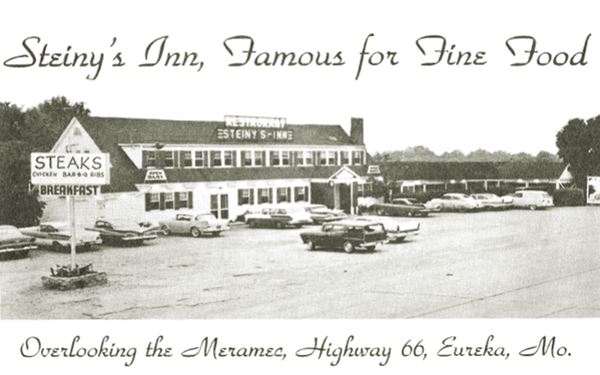
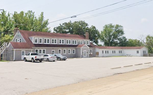
The old inn and former restaurant, and roadhouse now houses the Park's Visitor Center. It was built in 1935. It was strategically located on the eastern bank of the Meramec River, along the south side of US 66.
It had a restaurant which catered to those visiting the region or simply drove through, along Route 66. Over the course of the years it changed hands, and name several times. The postcard below shows the first of them: Bridghead Inn (1935 - 1946), so surely Rittenhouse drove past it. Then it became Steiny's Inn (1946), again Bridgehead Inn (1972) and finally Galley West (1980). Then the contamination issue arose, the town shut down, and business stopped.
The Key from the past
Right beside the Visitor Center, on its north side (see map showing the spot), is this neon sign once stood at the Site of Key’s Twin Bridge Gas Station and Cafe. It is a distinctive key-shaped neon sign that was saved from the now demolished cafe and donated by the Key family to the Route 66 State Park. See its Street View. It is pictured above.
The visitor center has exhibits that display a good collection of Route 66 memorabilia, historical artifacts, neon signs, and much more. It also has plenty of articles and information on the history of the former town of Times Beach.
Visit the Park's website for more information.
Now it is cut off from the Park it serves because the Meramec River US 66 Bridge is permanently closed and its deck was removed.
The "Then & Now images below show that the old inn has changed very little since the 1950s when it advertised as being "... located 17 miles west of St. Louis city Limits on Highway 66 overlooking the Meramec River at Times Beach", it offered Breakfast, Steaks, Chicken, and BarBQ Ribs.
1950s Postcard of the Bridghead Inn (Steiny’s Inn) in Route 66 State Park, Missouri
Current view of the former Bridghead Inn (Steiny’s Inn) in Route 66 State Park, Missouri
Meramec River US 66 Bridge
Just ahead is the historic bridge. Route 66 is cut off here because the bridge is closed to traffic, and its deck gone (removed in 2012); but it is still standing proud.
Listed in the National Register of Historic Places

The historic Meramec River bridge at Times Beach
The first bridge here was built across Votwa ford on the Meramec River, linking St. Louis with Eureka along the valley of Antire Creek. The Votaw Bridge built in 1900, a steel 10-panel Camelback Pratt Through Truss bridge. It may have carried the first alignment of Route 66 because it remained in use until 1933, overlapping the opening of the new alignment of Route 66 between St. Louis and Gray Summit in 1932. It was located just north of the now "historic" bridge that replaced it.
Historic Bridge features
The new bridge, built in 1931 and cosst $133,593. It was the first bridge in Missouri specifically designed to support cars. It was a three-span Warren Deck Truss bridge, 1,009 ft. long (308 m) and 30 ft. wide (10 m). The trusses are triangular beams used to provide support to the bridge. Warren patented a design in 1848 by which the triangles are equilateral. It rested on concrete piers and abutements. The deck with the roadbed was supported by horizontal chords.
A new brige is built (1956)
In 1956 a new set of lanes were built for eastbound traffic, and a new bridge was built to the south of the old one, which now carried westbound traffic only. In the late 1960s another set of lanes, now for westbound traffic was added to US-66 ⁄ I-44 to carry the westbound traffic and bypassing the original Route 66 through Times Beach and the old bridge, which remained open to local traffic.
In 1983 the town was evacuated and quarantined for cleanup. The bridge remained in use for that operation and, later, after the Route 66 State Park was created in 1999 it linked the western and eastern parts of the park. On October 29, 2009, the Meramec River U.S. 66 Bridge was closed to all traffic by MoDOT due to safety considerations and in 2012 its deck and roadbed were removed as can be seen in the photo above.
Saving the bridge
The bridge was set to be torn down in 2017, but a project (savethisbridge.org) promoted by different groups aims at restoring it and reopening it to pedestrian and cyclists. There is a fundraising campaign, and a plege by Phillip and Judith Stupp, MoDOT, Missouri Dept. of Natural Resources, the Great Rivers Greenway, and Landmarks Association to establish a $1 million endowment to maintain the structure. The bridge now belongs to Missouri State Parks and is ository for funds needed to complete the restoration project, which is estimated at $10 million.
Pollard's Texaco and Cape Cod Motel
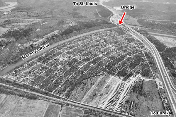
Located on the SW corner of Times Beach, at the point where the old cut-off Route 66 meets the freeway. It was a cabin complex with an "L-shaped" layout. It began as a Texaco filling station with some cabins and became Pollard's Cape Cod Cabins. You can see it on the upper side of this 1968 aerial photo on the north side of old Route 66 -the picture also shows the four-lane alignment that at that time wasn't yet a limited-access freeway. Below is a "Then and Now" sequence of Pollard's. Another long gone site is Laurel Courts.
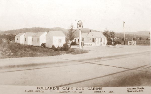
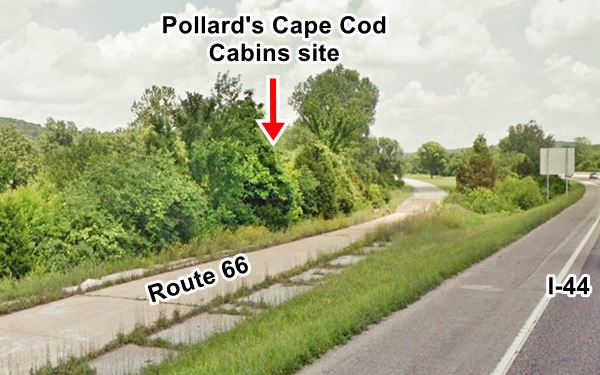
This leg of your Route 66 road trip in Times Beach ends here, drive west into Eureka to continue your Route 66 adventure!

Some sponsored content
> > Book your Hotel in Lebanon


Credits
Banner image: Hackberry General Store, Hackberry, Arizona by Perla Eichenblat
A Town, a Flood, and Superfund: Looking Back at the Times Beach Disaster Nearly 40 Years Later, EPA, 2020
Votaw Rd. Bridge
Jack DeVere Rittenhouse, (1946). A Guide Book to Highway 66


