Route 66 in Atlanta IL
Index to this page
All About Atlanta Illinois
Facts, information & Trivia
Elevation: 720 ft (220 m). Population 1,632 (2023).
Time zone: Central (CST): UTC minus 6 hours. Summer (DST) CDT (UTC-5).
Atlanta is a town located on Route 66 in Logan County, Illinois, USA.
Atlanta's history
Humans have been living in central Illinois since the end of the last Ice Age some elven thousand years ago. These people later evolved into the the Illinois Native Americans encountered in historic times. These people lived on the plains.
The French were the first Europeans to explore the area in the mid 1600s but settlement took place in the early nineteenth century along river valleys and forested areas. The grasslands were only settled after the railroad arrived, as it allowed farmers to ship out their produce.
Logan county was established in 1839 and in 1853 the Chicago, Alton & St. Louis railroad reached the area. A town was founded by the depot and was named "Xenia," a name chosen by the settlers who came from Xenia in Ohio.
As there already was a town named Xenia in Ilinois, one of the proprietors, a Mr. R. Gill suggested naming it after Atlanta in Georgia, a town he had recently visited.
The name: Atlanta
The Atlanta in Georgia was named after its railroad depot "Atlantica - Pacifica" which was very quickly shortened by the locals to "Atlanta". The ocean in turn was named after a Titan, Atlas, who was condemmned by the Gods to hold up the heavens for all eternity.
Atlanta's Hotels & Motels
Find your accommodation in town:
> > Book your hotel in Atlanta
More Lodging Nearby along Route 66
Below you will find a list of some of the towns along Route 66 east and west of this town; click on any of the links to find your accommodation in these towns (shown from east to west):
Along Route 66 in IL
- Hotels in Illinois
- Route 66 Starting point ▸ Chicago
- Lockport
- Willowbrook
- Bolingbrook
- Plainfield
- Romeoville
- Joliet
- Wilmington
- Dwight
- Pontiac
- Chenoa
- Normal
- Bloomington
- Atlanta
- Lincoln
- Springfield
- Raymond
- Litchfield
- Staunton
- Williamson
- Hamel
- Edwardsville
- Collinsville
- Troy
- Glen Carbon
- Pontoon Beach
- Granite City
- East St. Louis
West in Missouri
- Hotels in Missouri
- Florissant MO
- Bridgeton MO
- St. Louis MO
- Kirkwood MO
>> See the RV campground in neighboring Lincoln
The Weather in Atlanta
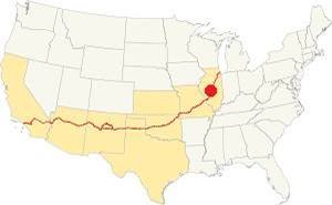
Location of of Atlanta, on U.S. 66 in Illinois
Atlanta has a humid continental climate with hot and humid summers, and cool to cold winters.
Winter (Jan): The average high is 34°F (1 °C); and the average low is 18°F (-7.8 deg;C). Summer (Jul): The average high is 85°F (29.7°C) and its low is 65°F (18.1°C).
Precipitation is lowest in January (1.93 in. - 49 mm) and peaks at 5.08 in July (129 mm).
Yearly rainfall is 36.7 inch ( 1,008 mm). Snow falls from November through March: 22 inches (55 cm).
Tornado risk
Logan County is struck by some 7 tornados each year. Tornado Risk: learn more about Tornado Risk on US 66.
Map of Route 66 in Atlanta
Heading southwards from McLean, the highway runs next to the railroad with a NE-SW course towards Atlanta. The 1926 to 1946 Route 66 was aligned through Atlanta's downtown commercial district in a course roughly parallel to the railroad, using a pre-existing Illinois state highway 4. See the yellow line in our custom map. However, the old alignment north of Sycamore street has been removed and only a short section of the original roadway can still be seen on the north side of town.
In 1947 the highway was moved to the eastern side of Atlanta, bypassing the town's business district; we marked this alignment with a red line in our map.
The Route 66 alignment in Atlanta
Visit our pages with old maps and plenty of information about US 66's alignments in this area.
- Springfield to Staunton IL (1926-30 US66) south from Springfield (next)
- Springfield to Hamel (after 1930) south from Springfield (next)
- Pontiac to Springfield (Atlanta's)
- Chicago to Pontiac (previous)

Atlanta's Route 66 Attractions
Historic context
In his "A Guide Book to Highway 66" (published in 1946), Jack Rittenhouse mentions Atlanta as follows:
garage; gas; cafes; no cabins or hotel... US 66 goes down one of the main business streets, past some very old store buildings, some dating back to the 1850's Rittenhouse (1946)
Your Route 66 Road Trip Leg in Atlanta
Four-lane alignment
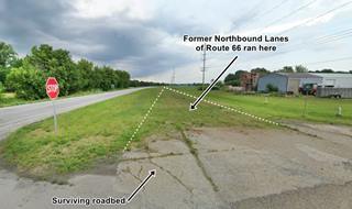
We will start our tour on the north side of town, driving southwards from neighboring McLean. The highway nowadays only has two lanes. The state removed the other two lanes when I-55 was built, to cut maintenance costs. When you reach Atlanta, at the crossroads with Sycamore St., to your right you can see the remains of the former northbound lanes of the 4-lane U.S. Hwy. 66 of the 1940s (pictured). This is its Street view.
On the NE corner of the crossroads was a Kerr-McGee gas station, gone in the 1980s; you can see it in this 1973 aerial photo.
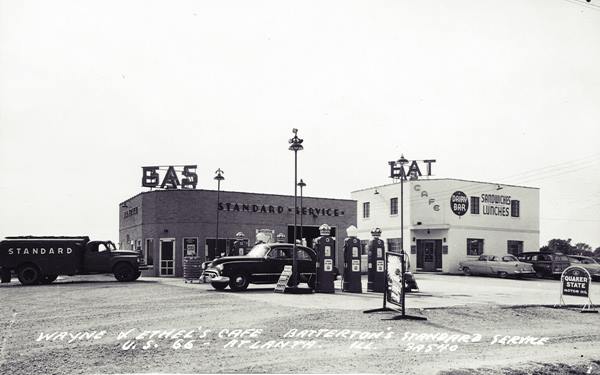
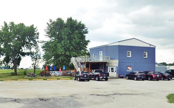
Wayne and Ethel's Cafe and Batterton's Standard Service
Turn left along Sycamore to enter town. Ahead, to your left on the south side of the street is the former Wayne and Ethel's Cafe that had "Sandwiches, Lunches, Dairy Bar". Next to it stood the now gone Batterton's Standard Oil gas station. They served those driving along the "Bypass 66" four-lane road. You can see both buildings in this 1973 aerial photo. Below is a "Then and Now" set of pictures:
Original 1920s US 66 Roadbed
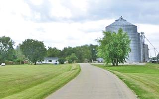
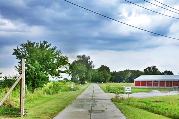
Drive west, the road curves as it reaches the railroad tracks and takes a NE-SW course. Here, to your left, look north along the original concrete roadbed of the 1926 Route 66. This highway was paved in the 1920s as Illinois State Highway 4, and in 1926 it carried Route 66 until it was replaced by the Bypass alignment in the late 1940s. Pictured below, it can be driven. It is only 700 feet long (210 m).
Brown's Texaco and Restaurant (gone)
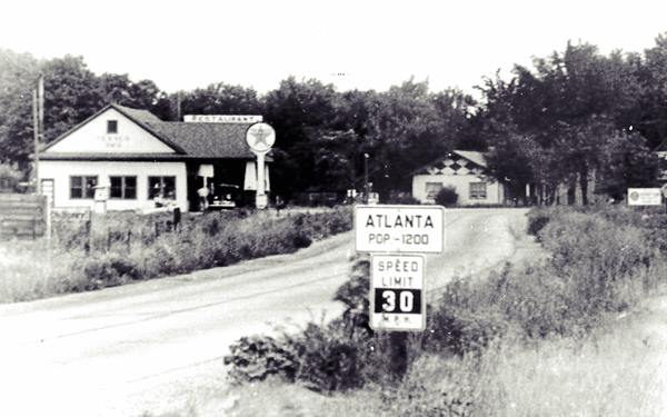
Drive south into the town. At the junction with E Williams St. was the long gone Jim Brown's restaurant and Texaco Gas station; below is a 1930s view of it. The thumbnail image shows the same view nowadays. The same curving road, but with modern silos to the right.
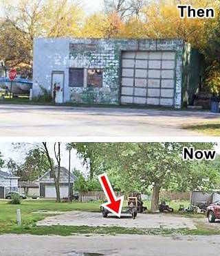
Atlanta Garage, 2012-2023. Click for St. view. 2012 photo source
On the next corner, at the crossroads with East St. there was a small garage, but it was torn down in 2012 all that remains is the concrete floor; see picture above.
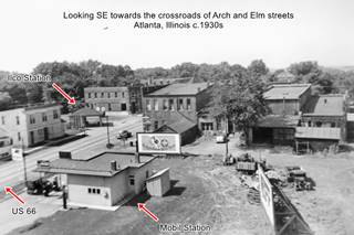
After the grain elevators, you will reach downtown Atlanta. On the SW corner of Elm St. there was a Mobil Oil filling station in the 1930s-40s. On the eastern side of the street, on the NE corner with Vine St. there was a hip-roofed Ilco Station at that time. See black and white image further up, click to enlarge it.
This part of town is where you can see the red-brick commercial buildings from the late 1800s mentioned by Rittenhouse.
American Giants Museum
Modern Route 66 Landmark
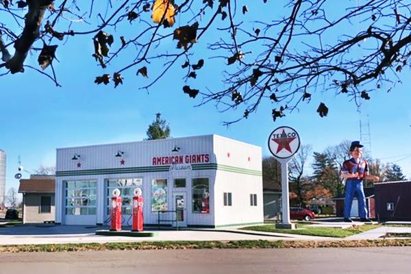
Built where the Ilco station once stood, the American Giants Museum is dedicated to the gigantic fiberglass statues that were popular during the 1960s and 70s along America's highways. The project aims at having the largest on-display collection of roadside giants in the world!
The building, designed to resemble a Teague-styled Texaco station will display information about their history and how they are being restored and saved.
> > Learn more about the Muffler Men on Route 66
Muffler Man Holding Hot Dog
The next block has several iconic Route 66 sights; the first is to your right, the Hot Dog Muffler Man:
Route 66 Attraction
Located at 115 SW Arch St. this is a 19 foot tall unique Muffler Man holding a hot dog (a giant hot dog). The giant is also known as Paul Bunyon (yes, Bunyon with an "o" and not Bunyan with an "a".)
Muffler Men
Muffler Men are gigantic (18 to 25 feet tall -5.5 to 7.5 m) statues moulded in fiberglass and polyester resin used in the U.S. during the 1960s and 70s as eyecatcher advertising along highways and streets.
The first Muffler Man was a "Paul Bunyan" figure created for the Paul Bunyan Cafe on Route 66 in Flagstaff circa 1960; later it became the Lumberjack Café and now is Granny's Closet. The original statue still stands nearby (street view of the Flagstaff Lumberjack today.)
The mold was later reused to make many more Paul Bunyans mostly placed in front of gas stations and garages. Some held auto tires, others held mufflers and that gave them the name of "Muffler Men".
Muffler Man Holding Hot Dog in Atlanta, Illinois
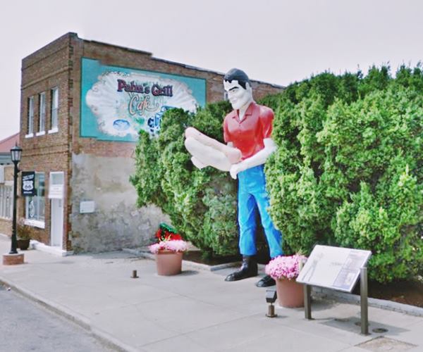
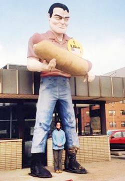
Hot Dog Giant in Cicero Illinois, Il. Source
Atlanta's Muffler Man was originally installed at the Bunyon's hotdog stand in Cicero, Illinois, also on Route 66 (see image). This stand was owned by Hamlet Stephens and he deliberately spelled its name "Bunyon" to avoid copyright issues.
His "Paul Bunyon" held a gigantic hotdog in his hands.
In 2002 the stand closed, and in 2003 the Bunyon Giant was moved to Atlanta. Stephens died in 2012 but his work lives on, to amaze those driving along Route 66.
Paul Bunyan
Bunayn is part of America's folklore, he was a giant lumberjack with herculean strength and accompanied by his loyal "Babe" the Blue Ox.
The loggers in the North American forests created the myth and the oral tradition was put down in paper and made popular in 1916 by author William B. Laughead (1882-1958).
Downey Building
Listed in the National Register of Historic Places
Across the street, to your left, is a historical building with a classic restaurant and a museum. Located at 110 and 112 Southwest Arch St.
This historic building is one of those "very old store buildings" mentioned by Rittenhouse in 1946.
A local businessman named Alexander Downey built it in brick in 1867, he chose bricks because he had lost a wood building during a fire in town.
It has an Italian-style design with arched windows on both of its stories, and that gave Arch Street its name.
It had two separate commercial areas, one was a bank, and later the Bevan law firm until 1960, and then the local paper was published here until a fire closed the building in 1973. it was donated by the Bevan's to the Atlanta Library and Museum.
The other half was a hardware shop, grocery and eventually a restaurant: the Palms Grill.
Palms Grill Café
Located in the Downey Bldg, at 110 SW Arch St. Robert Adams opened in 1934 offering "Home Cooking, Quick Service, Corteous Treatment" and "Plate lunch 25 cents."
Adams had lived in California and that is why he named it "Palms". He added a neon sign speling out "Palms Café" (still there, neatly restored.)
"Club Parties" were held at the Palms during the 1930s and 40s. The town's teens worked as waiters here during the 1950s. It closed in the 1960s. Empty for years, this north side of the building was later donated by the Hawkins family to the local museum.
Palms Grill Café 1930s in Atlanta, Illinois
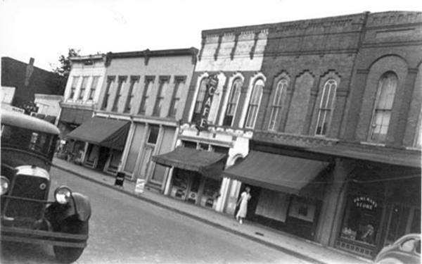
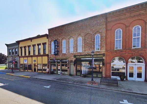
The building was listed in the National Register of Historic Places in 2004 which got the funding so that it could be rehabilitated.
A completely restored building now houses the Atlanta Museum and the Palms Grill
Atlanta Museum
112 SW Arch St. Its exhibits cover not only Atlanta's history but also Abraham Lincoln and Route 66. Open during tourist season.
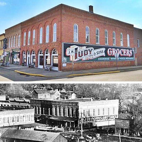
At the end of the block, to your left, on the NE corner of Race and Arch streets is an advertisiement-mural that recreates an original that stood on the red-brick building facing Route 66 traffic. Below is a "Then and Now" view of the mural and the building:
Atlanta Public Library and Clock Tower
Listed in the National Register of Historic Places
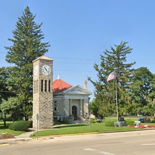
To your right, is the Atlanta Route 66 Park, on the NW corner. With some artistically rendered Route 66 Shields. On the south side of Race, Mattingly Automotive was formerly also a gas station with the pumps facing the corner. On the SW corner is the Historic Public Library:
100 Race St. The octogonal library was built in 1908 and the 36-foot clock tower was built next to it the following year. It has remained in open since then.
The Seth Thomas 8 day clock used to be in the Atlanta High School but was later moved to the library. It is an "8 day" clock because it has to be hand-wound every eight days. There is a group of volunteers "Keepers of the Clock" who do this job. The tower has a 1,200 pound brass bell that chimes on the hour.
Turn right along Race St. and cross the tracks; just ahead turn on 1st St. to the left, you wil see the red structure of the Historic Grain Elevator:
J. H. Hawes Grain Elevator Museum
Listed in the National Register of Historic Places
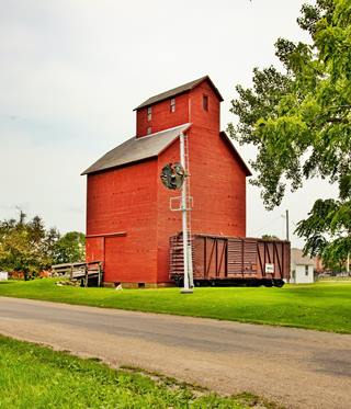
J. H. Hawes Grain Elevator, Atlanta. Click for street view. Source
301 Southwest Second St. This Grain Elevator operated from 1904 to 1976. It is a museum nowadays and it gives you a clear idea on how things worked in the past: Grain was dumped in a pit and then moved up into storage bins by means of a system of belts and pulleys powerd by a single cylinder engine. The grain was then moved out to rail cars.
It is Illinois' only fully wooden grain elevator. It has an outdoor, self-guided interpretive tour.
Free admission. Open June, July and August. Retrace your steps back to Route 66. This marks the end of your tour across downtown Atlanta, just south of this point is the Smiley faced water tank. You can get a good view of it along SW Arch St.
Smiley Tank

Smiley Face Water Tank, Atlanta, Il.
Bypass 66
For those interested in old gas stations, there are the sites of several gas stations on the Bypass 66 alignment. Head east along Race St. and South St. At the crossroads with the old four-lane alignment there were two Phillips 66 stations: The first was located on the SW corner of the intersection, where Casey's now stands; you can see the now gone gull-wing filling station in this 1973 aerial picture. Diagonally across from it, on the NE corner, was another Phillips 66 station (1973 aerial photo; all that remains is the steel pole that was once topped with the Phillips 66 shield (street view). Drive south to the crossroads of Race and Bypass 66, here there was a Sunoco gas station in the 1970s as you can see in this 1973 aerial image. (https://vintageaerial.com/photos/illinois/logan/1973/LLO/9/7).
Continue your Route 66 Road Trip
This marks the end of this leg of your road trip in Atlanta, head south to continue your journey and visit the next town: Lincoln passing by Lawndale on the way.

Sponsored Content
>> Book your Hotel in Chicago

Credits
Banner image: Hackberry General Store, Hackberry, Arizona by Perla Eichenblat
Jack DeVere Rittenhouse, (1946). A Guide Book to Highway 66.


