Oldest Mormon City in Arizona
Index to this page
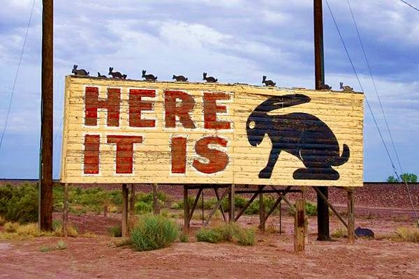
Here it Is Billboard by the Jack Rabbit Trading Post Route 66

TheRoute-66.com is reader-supported. When you buy through links on our site, we may earn an affiliate commission at no additional cost to you.
About Joseph City, Arizona
Facts, Trivia and useful information
Elevation 5,043 ft (1.537 m). Population 1,908 (2020).
Time zone: Mountain (MST): UTC minus 7 hours. Summer (DST) no DST⁄ PDT (UTC-7).
Joseph City is a small town in Navajo county in central-eastern Arizona, on Route 66.
Arizona has been inhabited for at least 10,000 years, but the natives that now live in the area are of a more recent origin. The Ancestral Puebloans or Anasazi, who were an agricultural society, lived on the Colorado Plateau (between the Colorado, Little Colorado, Puerco and Rio Grande Rivers to the south, and Southern Utah and Colorado to the north). They flourished between 700 and 1150 AD, but drought and war pushed them into New Mexico around 1300 AD, originating the Pueblo people.
The hunter gatherer Navajo (Diné) people occupied the territory and later adopted farming which they learned from the Pueblo Indians.
In 1539 a Spanish expedition under Francisco Vazques de Coronado reached the area and sent a group of men led by García López de Cárdenas to reconnoiter Arizona. They discovered the Colorado River and became the first Europeans to see the Grand Canyon. Their path took them by Joseph City.
The Spanish included Arizona within their province of Nueva Mejico which they established in 1597, nor did Mexico who succeeded Spain in 1821. After the U.S. defeated Mexico in the 1846-48 War, and annexed the region, it explored it and pacified the bellicose Navajos.
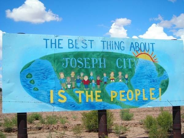
Billboard at the entrance to Joseph City, AZ. Route 66
The U.S. Army established Fort Defiance in 1851 and by 1868 had defeated the Navajo and settled them in a very large reservation, the current Navajo Nation. In the meantime Arizona had become a separate territory (1863) from New Mexico.
In 1857 Lt. Edward Fitzgerald "Ned" Beale (1822 - 1893) surveyed the wagon road from Ft. Smith Arkansas to California, and he followed a route that roughly lined up with what is now Route 66.

His expedition followed the Little Colorado River in this area, passing through the site where Winslow is now located. Beale employed camels, imported from Africa as pack animals. Although they were hardier than mules the Army declined to use them in the future because the camels scared both horses and mules.
In 1870 a small fort was established at Holbrook and soon after, the Mormons from Utah moved south into Arizona, they used a trail which was later known as the Honeymoon trail
Honeymoon Trail
The Mormon settlers in Arizona had to go back to Utah to marry because the closest temple was in St. George, Utah. To do so they took the "Mormon Wagon Road", which linked Lee's Ferry on the Colorado River with Sunset Crossing near where Winslow is today.
Arizona Historian Will Barnes christened this route as the "Honeymoon Trail" in an article he wrote in 1934 in the Arizona Highways Magaine. The name stuck.
The first Mormon settlement was esablished in March 1876, 3 miles to the east of the current townsite of Joseph City. It was named Allen City or Allens camp, after their leader, William C. Allen. They soon discovered a better location and before the end of 1876 had founded "Saint Joseph".
The post office opened in 1878, the Santa Fe Star Mail passed through the fledgling village. The Atlantic and Pacific Railroad, which later became part of the Atchison Topeka & Santa Fe Railway reached the area in 1883 and established a station.
In 1900, the town moved another 2 miles to the SW, but at that time the railway renamed the station "Joseph City" to avoid confusion with another station named St. Joseph along the AT & SF railway. The town would adopt that same name in 1923.
The other three Mormon settlements (Brigham City, Sunset, and Obed) along the lower Little Colorado River disappeared as the floods made it difficult for farmers to irrigate their crops.
Irrigation
The settlers had to deal with the Little Colorado River and its summer seasonal floods. They built a dam in 1876 which was followed by another 10 dams until the one built in 1894 proved tough enough to stand up to the floods.
The severe 1923 flood destroyed it and a new one, that is still in place, was built to replace it.
Lake Cholla, actually Cholla Cooling Pond Dam is a reservoir with a surface of 380 acres that is a water storage facility for the nearby power plant.
The name: Joseph City
It was initially called St. Joseph, after Joseph Smith, the prophet who revealed the Mormon faith. Later renamed Joseph City.
Joseph Smith, Jr. (1805 - 1844) was an American religious leader and founder of Mormonism and the Latter Day Saint movement.
The National Old Trails Road reached Joseph City in 1913, and it was incorporated into US Highway 66 when it was aligned along its Main Street in 1926.
The Interstate highway I-40 bypassed the town in the 1960s and business declined along the Main Street but the town still preserves some iconic places of the old Mother Road.
Getting to Joseph City
To the east is Holbrook (11 miles), Chambers and Houck. West are Winslow (22 miles) and Flagstaff (80 miles).
Where to Stay, find your Motel
There is lodging on Route 66 very close to Joseph City itself
>> Book your Hotels in Holbrook or in Winslow
Lodging Near Joseph City along Route 66
Grand Canyon Hotels
Click on Deals: Opens in new window
Heading East in AZ and NM
You are so close to Las Vegas!
Click on Deals: Opens in new window
Heading West, more Motels
- 22 mi. Winslow
- 61 mi. Twin Arrows resort
- 80 mi. Flagstaff
- 92 mi. Bellemont
- 113 mi. Williams
- 130 mi. Ash Fork
- 156 mi. Seligman
- 192 mi. Peach Springs
- 227 mi. Kingman
>> There are RV campgrounds in Joseph City, and nearby in Holbrook
Weather in Joseph City

Location of Joseph City on Route 66
Joseph City has a dry and semi-arid climate with hot summers and cold winters. The day-to-night temperature swing is considerable throughout the year due to the low relative humidity; this means that Summer nights are pleasant and cool, but winter nights are quite cold.
Average Summer high (Jul) 95.4°F (35.2°C) and the low is around 59.8°F (15.4°C). Average Winter high (Jan) 50.6°F (10.3°C)and the low is about 20.9°F -below freezing ( -6.2°C).
Rainfall is 9.2 in. per year (234 mm) and roughl half of it is concentrated between July and October (4.9 in 125 mm), there are about 50 days with precipitation per year. Snowfall is a scanty 2.8 inches per year (7.1 cm) and falls between Nov. and April.
Tornado risk
There is almost zero tornado risk in Joseph City: Navajo County has no Tornado watches. The area west of the Rocky Mountains has virtually no tornado events at all.
Tornado Risk: read more about Tornado Risk along Route66.
Map with the alignment of Route 66 through Joseph City
Route 66 ran through the town as its Main Street. Check this US 66 alignment in Joseph City
You can see the missing segments of US66 in Joseph City in our custom map.
Route 66 Alignment near Joseph City
With maps and full information of the old roadway.
- Winslow to Winona (next)
- Lupton to Winslow (Joseph City's)
- Albuquerque to Lupton (previous)
Sights and Attractions in Joseph City
What to Do, Places to See
- In Joseph City (below)
- Tours & Itineraries
Mormon Town
Joseph City is the oldest Mormon settlement on Route 66 in Arizona, it is well known for the "Here it Is!" Jack Rabbit Trading Post and the Howdy Hank's, Geronimo, and the now razed Ella's Frontier Trading Post.
Jack DeVere Rittenhouse in his "A Guide Book to Highway 66" published in 1946 reported that Joseph City had a population of 308. He also mentioned two motels (or "auto courts") the Hopi Village and the Oasis. It lacked a ca´fe but had gas and a garage.
Surprisingly, the Hopi Village was also the name of a Trading Post (now known as Howdy Hanks) perhaps there was a motel next to it.
The town has some interesting sights, we detail them below. Start your tour in the east, coming from Holbrook at I-40's Exit 280.
Geronimo Trading Post
5372 Geronimo Rd, Joseph City. Location map
Next to a low red sandstone hill, there has been a trading post here for over eighty years. The place is an example of Americana with wigwams painted with Navajo designs and petrified trunks. The shop sells souvenirs and Native American handicrafts.
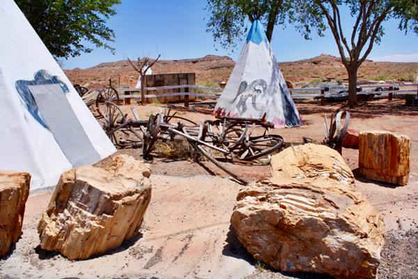
Named after Geronimo (1829 - 1909) a leader and medicine man of the Apache Nation. There is an Apache Reservation 80 miles south of Joseph City. The Apache lived in homes called "wikiup", a dome-shaped frame made of saplings covered with bark and grass. Some groups adopted canvas wigwams later. The local Navajo in the Joseph City region lived in houses called "hogan"; round or polygonal shaped buildings with timber or stone walls packed with earth, a door facing east and a bark roof.
Drive west, 2 miles ahead, at Cholla Lake to the south is the former Route 66 alignment, now South Frontage Road. It meets I-40 ahead at Exit 277, but originally headed straight into the city, meeting Main Street at its current intersection with Allen Drive. Leave the freeway at Exit 277 and head west along Main St.
Historic Old Fort Marker

Historic Old Fort Marker J. Hentsridge
click image to enlarge
Main Street, east of Joseph City.
Historic Marker
It is next to the Welcome sign pictured further up. The Daughters of Utah Pioneers erected their Marker No. 173 on March 22, 1952. It is located on the north side of Main St. after Allen Dr., to your right. Map showing the location of the marker. It reads:
THE OLD FORT
A group of colonists called by Brigham Young under the leadership of William C. Allen settled here March 24, 1876. They erected a fort of cottonwood logs and mud on this site. It was first known as Allen's camp. In 1878 the name was changed to St. Joseph, in honor of Joseph Smith the Mormon prophet. The people occupied the fort for several years during which time they lived the united order. In 1923 the name of the town was changed to Joseph City. It is the oldest Mormon Community in Arizona.
Navajo County.
The 1915 railroad map shows it as "Saint Joseph", with the station named "Joseph City". Both were unified in 1923 under the same name "Joseph City".
Drive on, at Main and Westover you can take a short detour to visit the Historic Bridge, just 1.5 mi. to the south.
Historic Bridge

Historic Bridge, Joseph City. Credits
Obed Rd. and Little Colorado River to the SE of the town.Map and directions.
Listed in the National Register of Historic Places
The bridge is made with riveted Pony trusses, steel stringers, timber deck concrete-filled steel cylinder piers and timber pile approaches. Using steel rol ed by Illinois and Ladkawanna, ftnaha fabricated the medium-span trusses and erected them the following spring The St Joseph Bridge was complete by June 1917. It has functioned as county bridge since. See a Street View of the bridge.
Head back to town and drive west along Main St.
Former Pacific Motel
4500 Main St, Joseph City. This was a U-shaped motel, on the north side of Route 66, now it is a self storage facility (Joseph City Storage). The now-and-then sequence shows us that the layout is unchanged and a gabled roof added.
The postcard announced that it was owend by Blen Blansett and it had "14 Ultra Modern Fireproof Units, all with Private Baths, Furnace Heat, Air Conditioned, Innerspring, Mattresses, Hardwood Floors...".

Pacific Motel vintage postcard
Source

Joseph City Storage
Source
On the next street, NW corner is another local attraction.
Garage
4500 Main St, Joseph City. Two buildings, to the right a shop with its parapet painted "Joseph City Route 66 Arizona", and to the left a Quonset hut Garage with a Coca Cola sign. Between them a naive mural of the state of Arizona with Route 66 and a cute Betty Boop showing her bottom with a "You Are Here" star marking Joseph City.
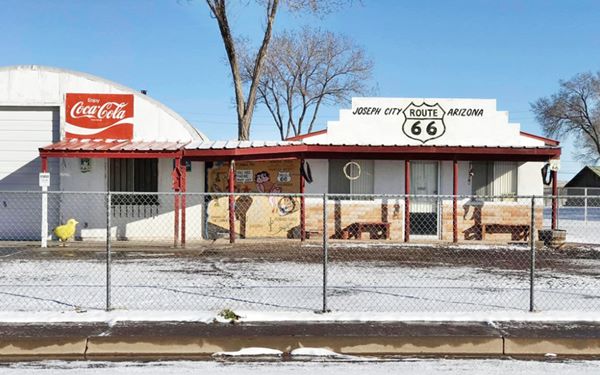
Another Old Garage
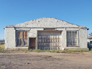
The road then curves to the north, past the "Dream Catcher" RV Campground, to your left is an abandoned garage.
It has a door with "475 W Main" written above it, two large windows and a large garage bay gate. Picture below.
Welcome Sign
Head west for 0.6 mi. and see the second "Welcome to Joseph City sign", to your left (map). Picture above.
Howdy Hank's
Main Street, west of Joseph City. Drive half a mile west, and just past the junction with 3rd. N St., see its location map. Note Google Maps identifies this place incorrectly, Google says it is Ella's Frontier Trading Post, but it isn't. Ella's was further west.
Howdy'Hanks in a 1950s photo
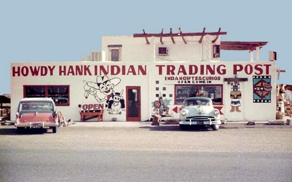
Howdy'Hanks slowly fading away!
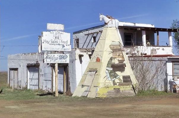
The original building is still there, with the upper floor. Three large doors have replaced the store's windows and entrance door, and a teepee topped by a horse has been added to its eastern tip. A sign with peeling paint proclaims "Hay Sales & Feed - Welding Shop".
The old store is on the north side of the road; this is.
It was owned by Howdy Hank, and began operating under the name "Hopi Village" in 1950 (or maybe earlier, in the mid 1940s) as a trading post cum motel and Route 66 souvenir store. Then Howdy sold the store to V.P. Richards who in turn sold it again, to Max Ortega. Ortega renamed it "Sitting Bull's Indian Store".
Business waned when Route 66 ceased to be the main thorughfare of town and the old post was reconverted to an animal feed store.
Site of Ella's Frontier Trading Post
Main Street, 250 yds. west of Howdy Hank's (Map with location).
Gone - Razed

Matches advertising Ella's Frontier. Source
The remains of the trading post were on the south side of the road, now a dead end but at one time ot was Route 66.
History
The post was set up by Frederick "San Diego" Rawson, who had lived as a child captive among the Indians. Rescued by the US Cavalry, he worked as Indian scout, trapper, wagon freighter, circus clown, prospector and cowboy. He was even a recognized poet; the "Poet of the Rockies", well known for his "Tales of the Range". He opened a museum to exhibit his collection of Wild West artifacts in Joseph City after Route 66 was created but closed it to set up his "Frontier Days Trading Post".
The building, according to Edward Haduck Peplow in his 1958 "History of Arizona" (pp. 152) was: "established in 1873... originally built by the early Mormon pioneers."
Ella's Trading Post before it was torn down.
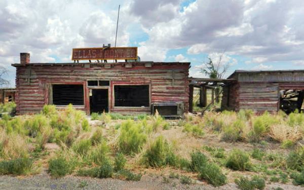
Some versions however say that he built it with telephone poles to resemble an "Old West" log cabin. He later renamed it "San Diego's Old Frontier". In 1947 later he sold it to Ramon Hubbell who in turn sold it to Ray Meany in 1951.
Ray Meany (1906-1987), former sailor and later composer of Hawaiian music "Aloha songs" ran the Golden Gate Publishers with over 400 copyrights and owned a steel guitar school in Oakland California. He was the owner of the Hopi House in Leupp Corner (1944 - 1951) and also acquired the "Old Frontier" from Hubbell.
Ella's Trading Post in its heyday
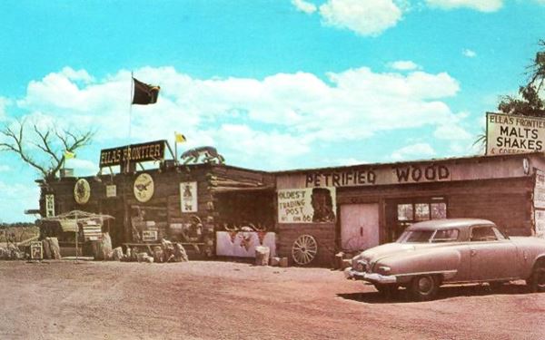
Later, in 1955, he sold his stake when he divorced his wife Ella Blackwell (1906-1984); as he put it: "My wife was jealous, so I gave up the music business to keep my wife. But she didn't like Indians, either, so we separated." He later owned hotels in Miami, Sasabe, San Diego, Twentynine Palms and Tucson.
Ella changed its name to "Ella's Frontier" and operated it until her death in 1984. She had studied music at Julliard and had a piano in the Trading Post. She also believed that it had been built by the Mormons, and therefore advertised it as "the oldest trading post on Route 66".
Of the assortment of things in her shop she said "It took me years to accumulate these things; it just didn'd happen".
Demolition and oblivion
After her death the building began its slow downward spiral of decay, and it was torn down. The story of its destruction), is the following: (1)

Ella's being torn down
video
"Feb. 18, 2021. ... A couple of years ago Elaine, who was really good friends with my parents, contacted me about Ella's. She owned the property & lives next to it... Elaine also wanted to know if we could maybe save the Ella's sign. She said she was to old to chase people off the property & was going to try & sell it. But if she wasn't able to sell, she wanted to level the store. It was too much of a liability to her... The Rice's from Joseph City ended up buying the property. I don't believe they were going to keep Ella's standing. ... Ella's Frontier & the sign will be saved and rebuilt at a nearby location. That location will be revealed in time."
Tours & Itineraries
Petrified Forest National Park
The nearby Petrified Forest National Park is a great attraction and it is Only National Park on Route 66
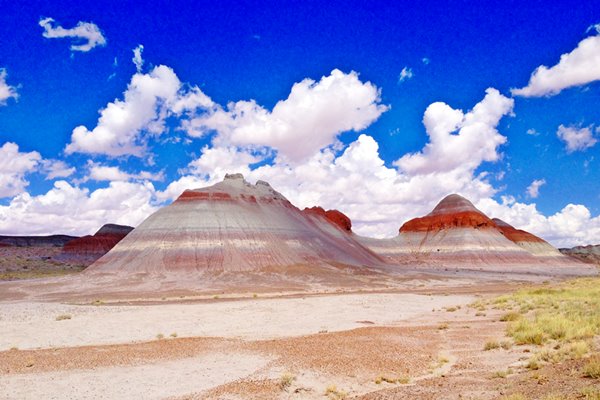
West of Joseph City, towards Winslow and Flagstaff
To the west of Joseph City the scenery and country side begins to change. You can start to glimpse far away, towards the west, the high snow capped summits of San Francisco Peaks. These are young volcanoes (6-million-years-old). The highest summit is Humphreys Peak, the remains of a stratovolcano, which is the highest point in the state of Arizona (12,633 ft - 3.853 m).
But Route 66 will cross the southern tip of the "Painted Desert", with bright red colored cliffs and grayish - red sands. It extends into Utah and lies between the eastern plateau and the Little Colorado and Colorado Rivers.
Visit the Jack Rabbit Trading Post
A Must-see Stop on Route 66
6 miles west of Joseph City along US 66. Jack Rittenhouse described this segment in 1946 pointing out that the "towns" of Manila, 3 miles west of Joseph City and Havre (9 miles from Joseph City) were not located on the highway and "[don't] even offer a gas station for the motorist.". They were merely railway sidings.
He did not mention the Jack Rabbit Trading Post because it opened in 1949, three years after he visited the area. Instead he pointed out that the first stop with gas and a cafe was the "Painted Desert Hideaway", 17 miles west of Joseph City and 4 miles east of Winslow.
Here are two small sidings on the railroad, Manila and Hardy.
Manila
Very likely named during the Spanish American War of 1898, when the American Navy defeated Spanis forces in Manila Bay (May 1, 1898), and later took the city (August 13, 1898).
Hardy
The stop was named after the first superintendent of telegraphs of the Atlantic and Pacific Railroad (which later became the Atchison Topeka and Santa Fe Railroad). It later changed its name to Havre because there already was a "Hardy" on the Santa Fe. Havre may have been chosen after the French port "Le Havre".
In this area, the Little Colorado Valley widens, and on its northern side you can see intersting rocks and pinnacles as well as mesas.
Jack Rabbit Trading Post

A Black tailed Jack Rabbit, Credits
On Route 66, on the south side of I-40 at Exit 269, 6 miles west of Joseph City.
Icon and Landmark
This is the Map and directions from Joseph City to Jack Rabbit Trading Post.
Texan trader James Taylor opened the Jack Rabbit Trading Post in 1949, after moving to Joseph City from Albuquerque. The building had first belonged to the AT & SF railway. Later it was the Arizona Herpetorium (exhibiting snakes). Jack Taylor set the snakes free and opened the Jack Rabbit Trading Post in 1949.
The Trading Post is still in operation and is a convenience store which sells curios and Route 66 collectibles.
A view of the wall of the Jack Rabbit Trading Post Route 66
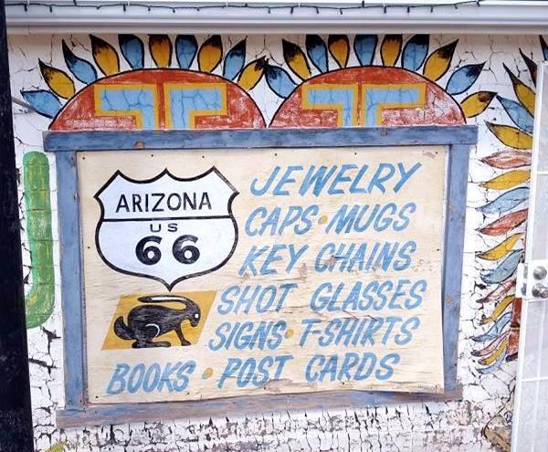
It is named after a hare that is quite common in the area, and all of the Western USA, the Jack Rabbit.
The black-tailed Jack Rabbit (Lepus californicus) or American desert hare is very common in the western U.S.
It can grow to weigh 6 lbs. (2.7 kg) and measure 2 feet (61 cm) long. It eats the local grasses, shrubs and trees. It does not hibernate. Coyote, foxes, wild cats and raptors prey on it.
Ride the Jack Rabbit
In front of the store is a large "man-sized" Jack Rabbit with a saddle which can be mounted by those passing by for a unique picture.
The rabbit itself has "mutated" over the years, from a disquieting looking hare to the modern reinforced fiberglass smiling bunny-like statue. See for yourself below.

The stark hare-like statue in the 1950s. R. A. Hird.

A smiling cute hare in the 2000s. Austin Whittall
Taylor had the original rabbit custom made. It had a wood frame and was covered in tough horsehide, padded with straw.
Just like many cartoon characters of the 1930s softened their images during the 1960s becoming cuter (think Bugs Bunny, Woody Woodpecker, Mickey Mouse), so did the menacing-looking Jack Rabbit at the trading post.
Stephen Jay Gould pointed this out 35 years ago: "Humans feel affection for animals with juvenile features: large eyes, bulging craniums, retreating chins. Small-eyed, long-snouted animals do not elicit the same response." (2)
The modern Jack Rabbit despite its long snout and ears, has some of the features of youth such as a large head, big rounded paws, large low lying eyes, bulging cheeks, short (due to the crouching posture) thick legs and a charming smile.
Riding Rabbits?

Youth riding rabbit, a 3rd Century BC Greek statue, Credits
Rabbit riding is indeed ancient; The terracota statue in the image depicts a young man riding a rabbit. It was discovered in Apulia, Italy and dates back to the Greek colonies in southern Italy, during the 3rd century B.C.
In Greco-Roman myth the hare represented romantic love, lust, abundance, and fecundity. Hare meat was believed to be a cure for sterility (they had the "gift of Aphrodite" or fertility). They were a symbol of the cycle of life, death and rebirth.
So during the days of ancient Greece and Rome, "riding a rabbit" probably had to do with propitiating fertility.
Rabbits are still considered good luck symbols ("lucky rabbit's foot"). But "riding a rabbit" is not actually something commonplace outside the realm of fairy tales.
However it can be found in this Finnish idiom: "ei olla jäniksen selässä", which means "not to be riding a rabbit" and is used to express that one is not in an immediate hurry, which is odd, considering that hares are a symbol of speed (Aesop's hare and tortoise fable).
American Wild West and Rabbit riding

Vintage postcard of a cowboy riding a Jack Rabbit
During the 1930s, it was quite common to see very similar humorous postcards from Texas, Dakota and Nebraska. They all depicted a cowboy or "cowpuncher" tending cattle but instead of mounting a horse, he was riding a giant saddled Jack Rabbit.
One of these is shown below, it was posted in 1939, and says on the front: "Texas cowboy riding a Jack Rabbit", and on the back: "Punching Cattle on a Jack Rabbit. And out here in the West they do punch cattle. Some of them do on Broncs and, even as you can see, some of them do on the lowly Jack Rabbit."
Notice how similar the Jack Rabbit in the postcard is to the 1950s statue shown further up, the posture is the same too, standing on all four legs.
The Jackalope
The Jackalope, is the mythical relative of the Jack Rabbit. A "horned" variety of jackrabbit, with deer-like antlers (like an Antelope, hence the name Jackalope).
It has been reported in South Dakota and Wyoming. Actually you can ride a giant Jackalope at the Wall Drug store in Wall, South Dakota. The Jackalope statue in Wall is very similar to the Jack Rabbit statue in St. Joseph (except for the antlers): smiling, friendly looking creature.
As most myths have some basis in reality, it is likely that rabbits infected with papilloma virus may have horn-like tumors growing on their head. These would surely explain the origin of the Jackalope myth. Similar horned beings (rabbits and squirrels) form part of Bavarian and Austrian mythology.
"Here it is" billboard
The iconic billboard with its upper edge lined with black rabbits, is on the south side of US66 on the eastern side of the Trading Post. We pictured it at the top of the page, it is a real eye catcher. See this street view of the Sign, at the Jack Rabbit Trading Post.
The movie Cars and the "Here it Is" billboard

Cars Movie billboard inspired in the Jack Rabbit Trading Post
The animated movie "Cars" (2006) shows in one of its scenes a yellow billboard with the silhouette of a Model T Ford, it says "HERE IT IS", a clear allusion to the outline of a rabbit and the same phrase on the original Jack Rabbit Trading Post billboard.
Like the original, the upper edge of the billboard has a series of black outlined Ford T cars.
The Movie, in its credits, acknowledged the historic trading post.
A Special Thanks To Those Who Inspire Us On Route 66, "The Mother Road"... Arizona ... Antonio & Cindy Jaquez, Jack Rabbit Trading Post, "Home Of The 'Here It Is' Sign", Near Joseph City, AZ.
Hare it Is!
Another Route 66 classic, the Henry’s Rabbit Ranch in Staunton, IL, is owned by Rich and Linda Henry. It has Route 66 collectibles and deals with higway and trucking memorabilia. The signs it uses are very similar but with a twist to the slogan: "HARE IT IS".
Jackrabbit Gas Station
3367 Old US 66. There was a Texaco station, with pumps right by the entrance to the old Trading Post as you can see in the image below, photo taken in 1962 by Ed Ruscha.
The Texaco at the Jack Rabbit Trading Post
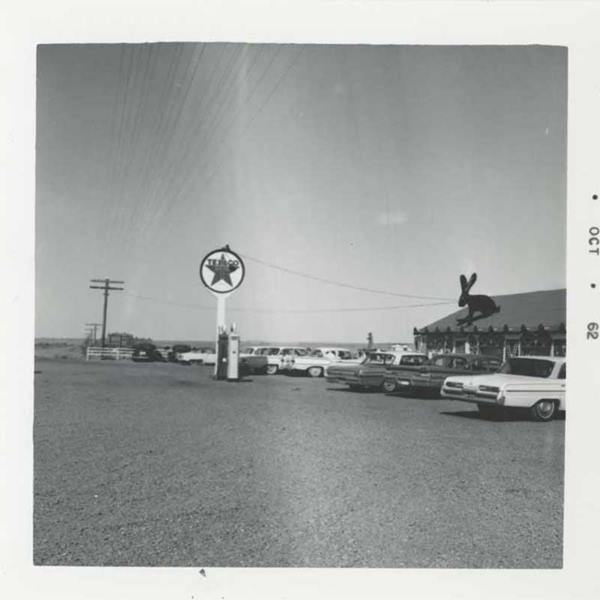
Did the new station open after the old one closed? It is located further west on Route 66, west of Jack Rabbit at the entrance to I-40 at Exit 269 is a closed gas station built in 1971, a brick building with a gable roof and a gabled canopy (street view).
Next Town: Winslow

Standin' on a Corner in Winslow AZ. Austin Whittall
Continue your Road Trip
The Jack Rabbit Trading Post marks the end of your Route 66 tour across Joseph City.
You can head west into Winslow to continue your Route 66 Road Trip in Arizona.
Sponsored Content
>> Book your Hotel in Winslow


Credits
Banner image: Hackberry General Store, Hackberry, Arizona by Perla Eichenblat
Jack DeVere Rittenhouse, (1946). A Guide Book to Highway 66


