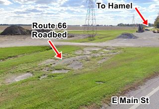
Route 66's old an new alignments meet
Index to this page
All about Staunton, Illinois
Trivia, Useful Information & Facts
Elevation: 620 ft (190 m). Population 4,528 (2020).
Time zone: Central (CST): UTC minus 6 hours. Summer (DST) CDT (UTC-5).
Staunton is a city in Macoupin County, in southwestern Illinois, on two alignments of Route 66: the 1926-1930 and the 1930-1940 Route 66 alignments.
History of Staunton
Human beings have lived in Illinois since the retreat of the glaciers at the end of th last Ice Age some 12,000 years ago.
The locan natives were Illinoisian Indians were the first to meet white settlers (French trappers and explorers canoeing down the main rivers from Canada) in the 1600s.
The Illinoisians were later moved out of the territory as European settlers occupied it.
The first settler was John Woods, from Virginia in 1817. The school opened in 1825 and the village was platted in 1835, followed by the postoffice in 1837.
Macoupin County was established in 1829 and named after Macoupin Creek named in turn for the Miami-Illinois term for the American lotus (Nelumbo lutea).
Staunton incorporated in 1859. The railroad arrived in 1870. It became a city in 1891 after its population hit 2,200.
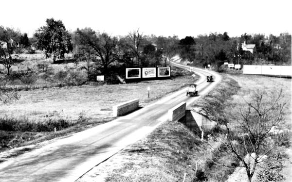
The Illinois Traction System passes through Staunton from 1904 to 1956. And in 1926 the original US 66 is aligned through town. In 1930 it was realigned to the east, grazing the town and bypassing its central district. In 1943 it was completely bypassed by the new alignment through Livingston.
The Name:Staunton
The story goes that a man named Stanton (without the "u") donated the land to the village for a square (accounts differ on the person, perhaps Thomas or James Stanton who were early settlers here). When the post office was to be named it was decided to pay homage to him by naming the post office after him.
The Post Office Service in Washington added the "u" resulting in "Staunton", which is also the name of a village in Virgina.
The surnames Stanton and Staunton are both topographic surnames given by Anglosaxons to people who lived near a Stanton or "Stony Ground".
Route 66 was aligned through the town in 1926 and in 1930 it was displaced to its eastern side. Finally in 1940 it bypassed Stanton completely, running past Livingston further east.

Staunton, its Hotels and Motels
Find your lodging & accommodation in Staunton (sponsored content)
> > Book your hotel in Staunton
More Accommodation near Staunton on Route 66
Below you will find a list of some of the towns along Route 66 east and west of this town; click on any of the links to find your accommodation in these towns (shown from east to west):
Along Route 66 in IL
- Hotels in Illinois
- Route 66 Starting point ▸ Chicago
- Lockport
- Willowbrook
- Bolingbrook
- Plainfield
- Romeoville
- Joliet
- Wilmington
- Dwight
- Pontiac
- Chenoa
- Normal
- Bloomington
- Atlanta
- Lincoln
- Springfield
- Raymond
- Litchfield
- Staunton
- Williamson
- Hamel
- Edwardsville
- Collinsville
- Troy
- Glen Carbon
- Pontoon Beach
- Granite City
- East St. Louis
West in Missouri
- Hotels in Missouri
- Florissant MO
- Bridgeton MO
- St. Louis MO
- Kirkwood MO
>> Check out the RV campground nearby in Douglas
Staunton's weather
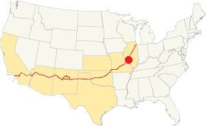
Location of Staunton on U.S. Hwy. 66, Illinois
Summers in Staunton tend to be humid, warm and long while winters are short and freezing as well as windy.
The average temperatures range from 21°F (-6°C) to 86°F (30°C).
The average summer (Jul) high is 86°F (30°C), and a low of 68°F (20°C). The January (winter) average low is 21°F (-6°C) and the average high is 35°F (1.7°C).
Snow falls for around 4.3 months, and Staunton's average snowfall is 22 inches (56 cm) per year. The yearly rainfall is 37.5 in.(952 mm)
Tornado risk
Staunton is in an region that is hit by about seven (7) tornados per year.
Tornado Risk: learn morel about the Tornado Risk on US 66.
Map of Route 66 through Staunton, Illinois
This is the map with directions from Benld to the end of the 1926 US66 on the south side of Staunton (see it in our custom map, with the brown line).
The original alignment continues through Staunton and on its southern side it ends at Williamson Rd.
In 1928 a straighter highway was being built between this point and Springfield, via Mt. Olive and Litchfield, to the east of Staunton. You can see it in the Illinois roadmap: the original 1926 alignment has been renamed "T 66" or "Temporary 66", with a new one built between Staunton and Litchfield along former IL-16, named "US 66".
This alignment was completed in 1930 and Temporary 66 was renamed IL-4.
South of this point, all the way to Worden "Wye" (called like that because of the "Y" shaped highway junction there), the 1926 alignment was absorbed into the 1930 road and remained in use until 1942 when a new road was built linking Worden with Mt. Olive via Livingston.
We describe this final segment in our Springfield to Hamel webpage.
The Route 66 alignment in Staunton
Visit our pages with old maps and plenty of information about US 66's alignments.
- Route 66 Hamel IL to St. Louis MO (Next)
- Springfield to Staunton IL (1926-30 US66 in Staunton)
- Springfield to Hamel IL (1930-77 US66 east of Staunton)
- Route 66 Pontiac to Springfield IL (Previous)
Staunton: its classic Route 66 Sights
Attractions & Landmarks
Jack Rittenhouse did not mention Staunton in his "Guidebook" to Route 66 published in 1946 because he drove down the later alignment finished in 1940 from Mt. Olive through Livingston, that bypassed Staunton along its eastern side.
There are very few former gas stations and no diners or motels in town belonging to the 1926-30s period, however, approaching Staunton from the north, coming from Mt. Olive on the 1940-77 alignment or from Benld on the 1926-30 alignment there are some interesting sights. Below we describe the two alignments into Staunton and their sights and stops:
- Sights along the 1926-30 alignment (coming form Benld)
- Sights along the 1930-40s alignment (coming from Mt. Olive)
Along the 1926-30 US 66 from Benld
The original higway built in 1919-20 has a missing segment at the railroad crossing 3 miles south of Benld and 2.5 miles north of Staunton:
Staunton Country Club missing road
As you can see in this 1973 aerial photo there is an original segment of highway on the southeastern side of the highway at Country Club lane - Gipsy Lane. The railroad crossing has been eliminated so it has dead ends on both streets. We marked it in our custom Route 66 map with a violet line. Don't miss the original 1920 ghost concrete paving on its northern tip next to the golf course (pictured)
The highway curves towards Staunton with an North-South course. As it enters the town you can see old gas stations that have been altered beyond recognition (Bud's to your left on the SE corner of W. Prairie and N. Edwardsville St). Ahead the road curves with a soft "S" along W North St. The "Historic 66" signs guide you southwards. The bank building to your right seems like a restored 1940s gas station (?), turn south. One block left at 401 W Main St. is an old Conoco Station & Garage on the corner. Now a liquor store. On the NE corner of Pearl and Route 66 was Carl Zuber's Standard Station; now it is Mayfields landscaping store. Here the highway turns right (signs mark the way) and four blocks west, it turns again southwards along S. Hackman St. ahead is a former Texaco.
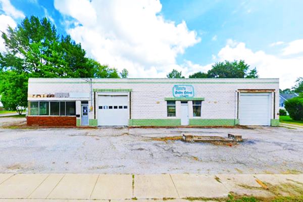
Neuhaus Texaco
Now Ron's Custom Cabinets owned by Ron Ocepek. This flat roofed single floor building at 514 S. Hackman St. (to your left) opened in 1940. It belonged to Bill Neuhaus and its glazed tiles make it stand out from its green urban surroundings.
Bill started selling GM trucks in 1947. Carl Zuber later moved here to "Carl's 66", a Phillips 66 station after selling the one in the downtown district.
The old service bays, office, and concrete pump island are still there.
Former Texaco and Phillips 66 gas station:
Drive south along State Hwy 4, it curves again and then runs straight south to meet the 1930 alignment where there is another landmark worth seeing.
Sights along the 1930-40 Route 66 from Mt. Olive into Staunton
Eastern of Staunton
Leaving Mt. Olive (see this map from southern Mt. Olive to Staunton) and heading south along the historic segment and the former four-lane alignment, the old Route 66's 1930-40 alignment turns towards the southwest from the East Frontage Rd. of I-55 just north of Exit 41.
At the fork, to your left was the now gone Gulf gas station and Café. To your right was a classic motel and gas station, also torn down:
Site of the 66 Terminal Motel
It began when Joe Roseman opened it in 1940 as a truck stop with cafe, gas station, garage and motel. John C. Meckles operated the garage and the filling station; he bought out Roseman in 1952. When I-55 bypassed it in 1977 it closed for good.
These two aerial photos taken in 1981 and 1967 look westwards showing the 4-lane US 66 in the foreground, the original cafe and gas station to the right (north), the long, single-story motel running north to south and behind it the original six cabins. The second motel to the south is on the left side of thes images. In the 1981 picture you can see the freeway running behind the complex. Now it is a scrapyard.
Short trip south to visit two sights (map with directions): 5.6 mile round trip.
Country Classic Cars
Just ahead along the old 4-lane '66 at 2149 East Frontage Road by I-55' Exit 41. It features over 400 classic cars and trucks and a Route 66 gift shop with collectibles.
Hi-Cafe site
Also in Staunton was the Hi-Cafe, it opened in 1956 and was located south of the fork of the 1930-40 Route 66, along the later four-lane 66 at Hi-Cafe Rd. and W Frontage.
The place belonged to Harold Hutchins and Frank Intahar (their initials named the cafe and the motel). When I-55 opened, it was cut off from its customers and closed in 1977.
See this street view and this aerial photo taken in 1964, the old cafe building has been modified and now is a
store, the motel on the south side, perpendicular to Route 66 was razed.
Retrace your setps to the site of 66 Terminal Motel and turn west along Old 66.
Route 66 Flea Market and Storage (Rocking chair)

Large Rocking Chair by 1930-40 US 66, Staunton. Click for St. view. Credits
Head west along the highway. Route 66 originally ran parallel to the tracks of the Litchfield and Madison railroad - L& M (the tracks have been removed, they ran on the north side of the highwya). Half a mile west of I-55, to your left at 20623 Old Route 66, Staunton, is a flea market and if you are into antiques and odd old stuff you might want to stop here and take a look around.
Its main attraction is an ovesized rocking chair (pictured).
Along the 1930-40 US 66 in eastern Staunton
Route 66 and E. Main - old roadbed
Ahead Route 66 crosses E. Main St. (Staunton Rd.) this crossroads was altered over the years to make it safer.
It was a very sharp angled crossing not a "+" but more like an "x" so it was rebuilt in the early 1980s to make it safer.
Compare this 1956 aerial photo with its current appearance. The picture shows a cracked slab of the original concrete highway at the crossing.
Cross East Main and head south along Old Route 66, that ran on the eastern side of the now gone L&M railroad. The road curves west and then to the southwest with fields to the left and some houses to the right. Ahead, to your right is the best known sight in Staunton.
Henry’s Rabbit Ranch
Classic Route 66 Wacky Attraction
At 1107 Historic Old Route 66. this place is the work of Rich and Linda Henry. It was inducted in 2012 to the "llinois Route 66 Hall of Fame".
It is a landmark made to fit Route 66, it celebrates the spirit of the mother road with joy and wacky stuff. For instance, The Standard Oil gas sation looks real but it is a replica.
The replica gas station at Henry's Rabbit Ranch:
Hare it Is
Its "Hare It Is" sign is a wink to the well known Jack Rabbit Trading Post in Joseph City Arizona,with its famous "Here it is!" billboard, both jackrabbit and hare are pictured below.

The Hare at Henry's Rabbit Ranch. Credits

A smiling cute hare at Joseph City's Jack Rabbit Trading Post. Austin Whittall
It is a celebration to US 66 and has a good collection of memorabilia. The site housed the old neon sign of the Stanley Courtel Motel but it has since been moved to St. Robert to be restored. It also has some classic Campbell 66 trucks facing the highway:
Campbell 66 Express

Vintage 1950s picture, Campbell Express truck. Credits
Franklin George Campbell founded the trucking company in 1926 in Springfield, Missouri. By 1933 it had acquired the Rapid 66 Express and was running between Springfield and St. Louis along U.S. 66.
Campbell pruchased many truck companies over the next decades expanding his company to 26 Midwestern and Southern states.
The 1980 Deregulation Act placed strict regulations on trucking and this liquidated the company: it went bankrupt in 1986.
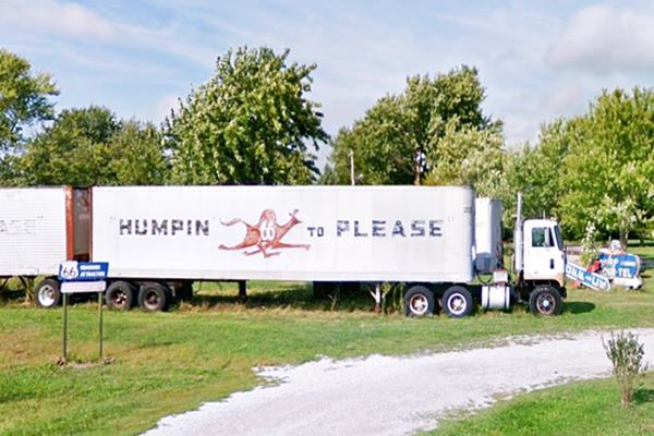
Their logo and mascot was "Snortin' Norton" the camel. It was painted on their trucks with their motto: "Humpin to Please" as you can see in the vintage photo and the trailer at Henry's pictured below:
Campbell 66 truck and trailers at Henry's Rabbit Ranch, Staunton, Illinois
Rabbit Ranch: Buried Cars a parody of Cadillac Ranch
The buried cars consist of a group of seven cars half-buried in the ground, with four facing one way and three the other, they are almost vertical, and are of different makes.
They are a homage to the well-known art work from the 1970s: The Cadillac Ranch on Route 66 close to Amarilo Texas, with its half-buried Cadillacs.
The Buggy Farm in Conway Texas, on Route 66, east of Amarillo is another parody of the Cadillac Ranch, known as the Bug Farm, Buggy Ranch and Bug Ranch. It consists of five Volkswagen "beetles" buried nose-down in the ground. There is another "buried car" on Route 66 at John's Old Place in Arcadia, Oklahoma.
Cars buried nose-down in the ground:
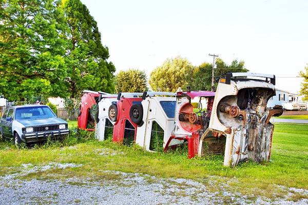
The "buried cars" at Henry's Rabbit Ranchin Staunton, Illinois
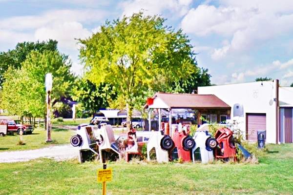
You can learn more about Henry's at their website www.henrysroute66.com. Schedule a visit.
Head south along Route 66. After a set of sharp curves it meets the 1926-30 US 66 on the south side of Staunton.
Alignments meet on the south side of Staunton
You can read all about this last leg of the Springfield to Hamel (1930-77 US66).
The 1930-40 highway that skirted around Staunton's eastern flank met the 1926-30 alignment roughly 2.5 miles south of downtown Stauntonm this junction pictured below:
Route 1926-28 and 1928-42 alignments meet south of Staunton, Illinois
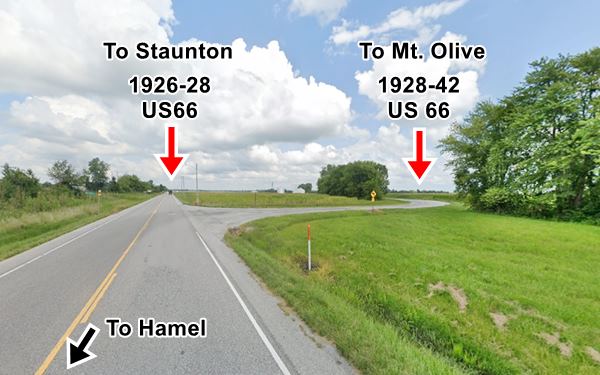
Originally it wasn't a "T-shaped" junction but a crossroads with a "Y-shaped" alignment. A lot of traffic came by here in the 1930s and 40s. also while the four-lane alignment was being built between Worden Wye - Livingston, and Mt. Olive.
On the SW corner of this junction was a classic Route 66 Roadhouse:

Decamp Junction Roadhouse, Staunton, Il.
Click for street view. "Then" credits.
Decamp Junction Roadhouse
8767 State Route 4 (Historic US 66). This is a historic roadhouse and in the past there was tourist cabins a dance hall and even a brothel. It was next to a gas station on the 1926 to 1940 alignment of Route 66.
Illegal alcohol and gambling were rife in the early 1930s when gangsters robbed the place. Now it is a tavern with plenty of US 66 mementos and photos. Check its "Now" and "Then" appearance in the picture:
Originally it stood on the opposite side of the highway. It opened in 1931 and was run by Alois and Elnora Duda.
You can see it in this 1955 aerial photo on the lower left side of the junction of IL-4, the 1930-40 US66 and Spangle Rd.
The original Route 66 together with IL-4 ran south from this point for 3 miles to Worden's junction at Possum Hill Road and from there to Hamel. We describe this section in our Hamel webpage.
This leg of your journey through Staunton ends here. Continue your Route 66 Road Trip westwards along the Main 1926-77 alignment and visit Hamel.

Sponsored Content
>> Book your Hotel in Chicago

Credits
Banner image: Hackberry General Store, Hackberry, Arizona by Perla Eichenblat


