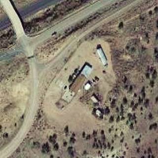
Route 66 in Allentown AZ
Index to this page
About Allentown, Arizona
Facts, Trivia and useful information
Elevation 6,145 ft (1.873 m); population n⁄a.
Time zone: Mountain (MST): UTC minus 7 hours. Summer (DST) no DST⁄ PDT (UTC-7).
Allentown is a small unincorporated community located in Apache county; part of eastern Arizona's Navajoland. Route 66 has ran through it with different alignments since 1926.
History
Arizona has been inhabited for more than 10,000 years, and along the Colorado Plateau lived the Anasazi people. Their southern border was the Puerco of the West and the Little Colorado rivers. They were farmers who reached their peak between 700 and 1150 AD. Then they moved to the southwest into New Mexico where they originated the Pueblo People.
The current native people, the Navajo reached the area ca. 1400 AD. They were like the Apaches, of Athabaskan origin, with their roots in Canada, and migrated south into SW USA.
The Navajo (who called themselves Diné - or "People") were hunter gatherers who later learned farming from the Pueblo people.
In 1539, Francisco Vazques de Coronado reached the area and occupied Zuni Pueblo before moving east through the Rio Grande and into the Great Plains. He sent a group of men under the command of García López de Cárdenas to check out the rumors about a great river, the "Tison" to the west of Zuni Pueblo.
Cárdenas marched west from Zuni and followed the Rio Puerco of the West near the spot where Allentown is now located. Guided by Hopi Indians, the Spanish reached the Grand Canyon and became first Europeans to see the Grand Canyon and the Colorado River.
Spain incorporated Arizona to their American colonies, but never settled in the region. They met and named the "Navajo" in 1620 in New Mexico (which they did settle). The word derives from "Apachu de Nabajo" (Apache of Nabajo).
The Navajo raided the Spanish villages in Colonial New Mexico from bases in their homeland in NW New Mexico and NE Arizona, these raids continued after Mexico won its independence from Spain in 1821. After Mexico ceded the territory to the U.S. after its defeat in the 1846-48 Mexican-American War, the American Army devised a plan to pacify the region.
Fort Defiance was erected by Col. Edwin Sumner in 1851, in what is now Arizona, in the heart of Navajoland. It was attacked several times in the 1850s, and due to the onset of the American Civil War, was abandoned in 1861.
Historic Trivia
Apache County has the most land designated as Indian reservation of any county in the United States (68.34% of its area). Neighboring Navajo County is in third place.
The Navajo were engaged and defeated in 1862, and badly treated in an internment camp. Public uproar led to the establishment of a "Navajo Reservation" (1868) and peace prevailed.
The Star Mail Stage Route, from Ft. Wingate NM, to Navajo Springs (near Navajo on Route 66) went through this area. Apache County was created in 1879 and in 1895 Navajo county was split from its western part. The Atlantic & Pacific Railroad which later became a part of the Atchison Topeka and Santa Fe RR (AT&SF) built its tracks westwards from Gallup, extending their tracks into the area in 1881 following the Rio Puerco of the West River.
The name: Allantown
Now its name is written Allentown, with an "E", but its original name was "Allantown" with an "A".
It was named after Allan Johnson, who was part of the Atlantic and Pacific Railroad staff in the construction Department.
The Apache County map further down, the USGS map of 1923, Cronmeyer's tokens (below), and the AT& SF Railway map of 1881 below, all show it as "Allantown" not "Allentown", so the "A" must have become an "E" after the early 1920s or 30s.
The map from 1881 shows "Allantown" (with an "A" and not an "E") as a railroad siding. Notice the highway running along the south bank of the Puerco River.
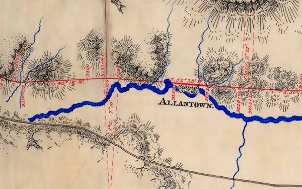
The records show that "Allan Johnson ... and his brother settled near this place in the Eighties and ran cattle for several years." (1)
By the way, the name Allan, in British "Alan" means "Swift like a greyhound", it comes from Saxon "Alwin" that means "who wins all", and Celtic "Aluinn", "illustrious" and also "sparkling and beautiful" hence its use in naming rivers.
The railroad brought traders and migrants. One of them, a German named Curt Freidrich Cronmeyer (1855-1915) opened a Trading post, and married two Navajo women. He adopted the policy of all trading posts: he didn't pay the Navajo or Hopi in cash. Instead he bought their handicrafts and gave them tokens that could only be redeemed at his store. A terrible vicious circle for the natives. He was shot dead with his employee C. A. "Red" McDonald on June 27, 1915 by some Mexican bandits. He is buried in Gallup

1898 bronze Cronmeyer Trading Post token. Source

Grubbs White Mound Trading Post token. Source
New traders appeared: the 1930 Arizona State Business Directory says the following:
ALLANTOWN.
Postoffice in Apache county, on the A., T. & S. F. Ry., and "Old Trails." Transcontinental Highway, 65 miles northwest of St. Johns, the county seat. Gallup, N. M. is the nearest banking point. Population 35. Altitude 6,050 feet.
GRUBBS JOS A, postmaster
WHITE MOUND TRADING POST, Jos A Grubbs prop, genl mdse Az State Business Directory (1930)
Grubbs also sold his general merchandise with tokens, at prices far higher than they'd have got if they'd been paid in real American currency. He went out of business in the late 1940s.

Where to Stay: your hotel near Allentown
There is no lodging on Route 66 in Allentown, but you can find a hotel nearby in Gallup NM. or in Chambers AZ
> > Book your Hotels in Gallup or Chambers
More Accommodation near Allentown on Route 66
There are plenty of lodging options in the cities and towns along Route 66 east and west of Allentown; click on the links below to find your accommodation in these towns, listed from east to west:
Eastwards
In Arizona Along Route 66
Westwards
You are so close to Las Vegas and the Grand Canyon!
>> There are RV campgrounds near Allentown, in Holbrook AZ
Weather in Allentown
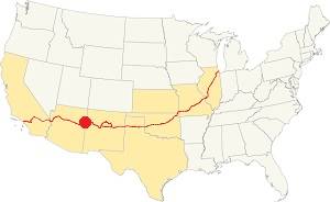
Location of Allentown on Route 66
Allentown's climate is semi-arid and dry. Summer is hot and winter is cold. The day-to-night temperature swing is considerable throughout the year due to the low relative humidity; this means that Summer nights are pleasant and cool, but winter nights are quite cold.
The average high temperature during summer (July) is around 95°F (35°C) and the average summer low is approx. 59°F (15°C).
The winter (January) average high is 50°F (10°C); and the average low is 21.9°F which is below freezing (-6.1°C).
The arid area does not receive much rainfall, only 9.5 inches per year (240 mm). Half of it falls during the Summer Monsoon period from July to October (5 in. - 127 mm). There are some 49 days with precipitation every year.
Snowfall is light with about 6.5 in. per year (16.5 cm), which falls between October and April.
Tornado risk
There is almost zero tornado risk in Allentown: Apache County has no Tornado watches. The area west of this point has no tornado events at all.
Tornado Risk: read more about Tornado Risk along Route66.
Map of Route 66 through Allentown Arizona
>> Custom map of Route 66 in Allentown

Lupton to Houck, detail of 1937 map. Source
Click on image to enlarge
West of Lupton, the 1926 to 1960s Us 66 followed the alignment in this map from Exit 359 to 354. Head west from Lupton; the thumbnail map (click on it to enlarge) shows Allantown and a building there (next to the "A" of Atchison) west of the depot, that probably was a trading post.
At Exit 354 the original highway is now cut by the freeway, and it headed north, running under I-40 as shown with the green line in our custom map. The curved segment see map north of the freeway was part of the N.O.T. but never carried US 66.
The old US66 reappears, and for the next 2.5 miles it runs along the north side of the freeway (map) as the N Frontage Rd., it curves around a rest area and reaches Allentown at Exit 351. Here there is a fork in the alignments.
Route 66 Alignment near Allentown
With maps and full information of the old roadway.
- Winslow to Winona (next)
- Lupton to Winslow (Allentown's)
- Albuquerque to Lupton (previous)

Allentown, Arizona, Its Sights and Attractions
Things to Do and Places to See
Historic Context
During US 66's heyday, Jack DeVere Rittenhouse in his "A Guide Book to Highway 66" published in 1946 describes Allentown as follows:
Now the bluffs on both sides of the road begin to separate as you emerge onto a wide area, forested with scrub pines.... Stafford's Cafe, including gas, groceries, and a curio shop, comprises town of ALLANTOWN here. Rittenhouse (1946)
Yes, Rittenhouse calls it Allantown with an "A".
Road trip across Allentown
Driving westwards from Lupton at its I-40 Exit, the South Frontage Rd. is the original alignment of Route 66 and takes you to Allentown. This is the map from Exit 359 to 354 of the 1926 to 65 US 66.
This highway had been built as the "Adamana to Lupton Highway". After Lupton there was a bridge across Lupton Wash, built in 1927 and rehabilitated in 1939, the images below show it in 1939 and nowadays:

1939 photo Lupton Wash Bridge, US66, Lupton AZ. Source

Lupton Wash bridge nowadays. Jim Ross
Unnamed Trading Post
There was a trading post or gas station on the south side of US 66 1.8 miles beyond the bridge; this map marks the spot. You can clearly see it in this 1970 aerial photo
Stafford's Cafe ❌ (Gone)
This cafe mentioned by Rittenhouse was just 0.7 mi. further west, on the top of a low hill . Below is a view of the highway in this section looking east towards Stafford's Cafe site.
This map marks the spot where it stood; it was torn down in the late 1990s. It can be seen in the following aerial photo from 1970
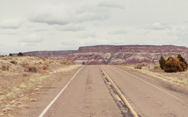
This 1962 aerial photo shows the spot that you can see in the image above. In the aerial photo you can see a long building parallel to the highway and the new 4-lane freeway just north of it (top). We haven't been able to find any postcards of Stafford's.
At Exit 354 the original highway is now cut by the freeway, and it headed north, running under I-40 as shown with the green line in our custom map. The old 1920s-1965 US 66 runs along the north side of the freeway as the N Frontage Rd., it curves around a rest area and reaches modern Allentown at Exit 351. Here there is a fork in the alignments and three trading posts here.
Three Trading Posts in Allentown
To your left on the Northwest side of the exit, is Chees Indian Store.
Chee's Indian Store
It has bee run by the Chee Family (their name "Chee" means "red" in Navajo) for four generations and they sell Navajo handicrafts. Eva Chee began selling local crafts next to Route 66 in the 1930s, by 1948 she had established the store on the highway. When the freeway was built in the 1960s, the original store was torn down to make way for the westbound lanes of I-40. a new store with a Rock Shop was built at exit 351. Below are two vintage postcards of the store, and this is the Street view.
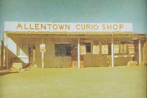
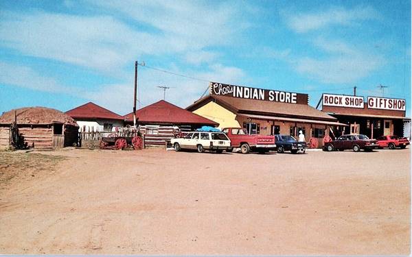
The postcard states: "Chee's Indian Store - Allentown Road I-40 Houck, Arizona."

Tepee Exxon at Ortegas Indian City in 1979. Source
Ortega's Indian City Arts
Facing Chee's, on the right side of the exit, in its NE corner is a trading post that has gone through many changes over the course of the years.
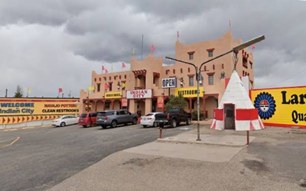
It had a gas station selling Enco brand gas (after 1972 it became Exxon) whose office was a tepee. The tepee is still there. You can see it in the modern picture below, and in the other image as it looked in 1979 when photographed by John Margoulis.
Max Ortega (1905-1979) had lived all his life in Lupton, a member of a pioneer Arizona family. He traded and opened his post in Lupton in 1946 with his son Armand.
Another son, Gilbert (1936-2003) started working at his father's trading post in Lupton.
He built his first store in the mid 1960s in Allentown and developed the Indian jewelry retail and wholesale business. By 1977 he had 16 stores but refocused on high-level fine stores after the 1980s.
In his early days in the mid 1960s, he saw a dome in Showlow AZ (still there, see street view) he learned it had been sold Black Canyon City AZ and thought it was a great design for his stores.

Ortega's dome-shaped store on US66, Houck AZ in 1979. Credits
He built the first dome in Lupton, and the second, even larger on a lease from John Tin Smith, a Navajo that included an Enco gas station here in Allentown.
He partnered with Carl Kempton and built a string of geodesic domes in the late 1960s along Route 66 (Meteor City and Barringer Crater).
As the domed Indian City, notice the tepee to the right
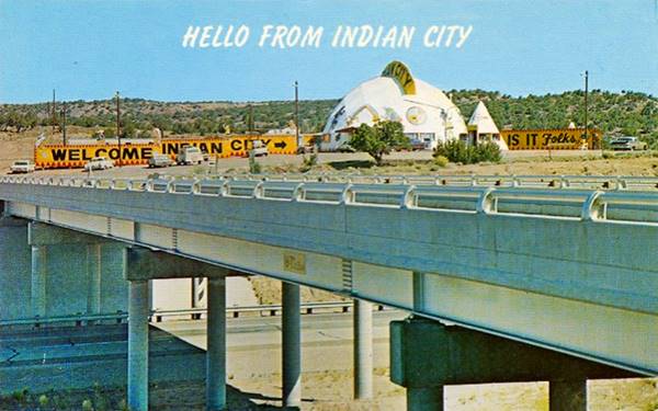
By the mid 1990s, the old dome had gone and a Pueblo-style building had replaced it. The tepee however, managed to survive.
Nowadays, as Indian City Arts, the tepee is still there!
Third Trading Post
On the south side of the freeway, on the SE corner of old Route 66 and Allentown Rd., is another trading post.

1970 aerial photo Allentown AZ. Source
The 1970 image shows a building that is flanked by four tepees, and has a canopy? perhaps also sold gas. The current Street view shows two concrete gas pump islands and the building is still standing.
Route 66 west from Allentown
Here, by this unnamed trading post, the N.O.T. highway and the 1926 to 1930s rout 66 turned souh and headed towards the Rio Puerco river, crossing it.
The highway crossed then ran along the south side of the Puerco all the way to Sanders, where it crossed the river again. This is the map of 1926-30 Route 66 from Allentown to Sanders. Drive it with care it is a rough dirt surfaced road.
Old Bridge (1923) at Allentown
Listed in the National Register of Historic Places
Built in 1923 as part of the National Old Trails Road. Three years later it was included in the first alignment of Route 66 through this area. See this vintage photo of the "Allentown" bridge on the "Adamana to Lupton Highway" taken in 1924, two years before US 66 was created.
Map showing where it is. This original alignment ran south what is now I-40, and also, south of the Rio Puerco River, so it crossed it twice, one here, next to Allentown, and again further west, at Sanders. Built in 1923 on the Old Trails across the often flooding Puerco of the West River. It had a wood deck supplied locally to reduce the construction costs.
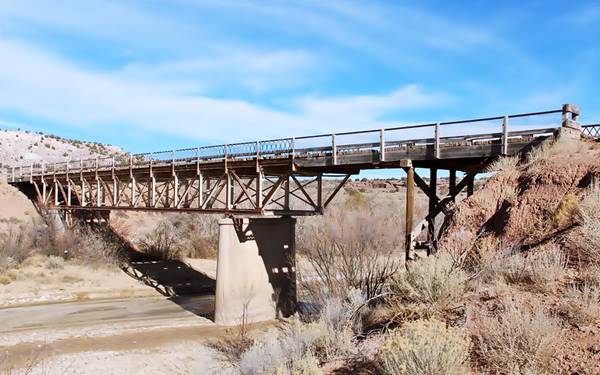
The Allentown Bridge was a Pratt deck truss bridge. Truss is the steel structure formed of triangular units that give the bridge its strength. A "Deck" truss is one where the deck (roadbed) is placed on top of the truss. And a Pratt truss is shaped so that the diagonal beams face towards the center of the bridge. The deck was built in wood, this was supplied locally and lowered the bridge's construction costs
It is closed to traffic, but you can see it to your left, on the eastern side of the modern bridge that replaced it.
This alignment did not go through Houck, it passed well to the south of the village.
You can drive this segment along the original roadbed along Co. Rd. 7240, covering 15.5 miles along a rough back-country road with no services along it, it leads you to the next town along the oldest alignment, Sanders.
The 1930 - 1947 Alignment from Allentown to Sanders
The paved highway in 1930 was realigned along the north side of the Rio Puerco River, and in doing so, went through the small community of Houck. The segment from Allentown to Houck is overlapped by the westbound lanes of I-40 built in the mid 1960s. However, some maps state that it runs along what is now the North Frontage Rd. into Houck we will follow this alignment; see the Map (1930-65) Allenton-Houck.
Continue your Road Trip
This leg of your Route 66 road trip in Allentown ends here. Head west to visit the next stop in your journey (along the paved '66): Houck followed by Sanders.
National and State Parks, Outdoors
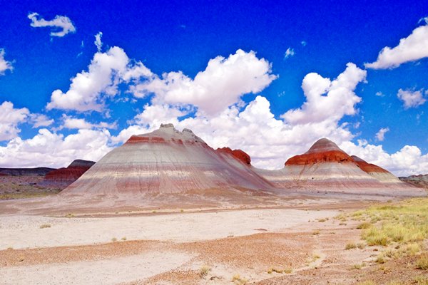
Petrified Forest National Park
Tip: consider visiting the Petrified Forest National Park (near Holbrook) on your Road Trip.
It is the Only National Park on Route 66
Lake Havasu City

Lake Havasu City, the lake and London Bridge. Source
The resort town of Lake Havasu City on Lake Havasu has beaches along the lake's scenic shoreline, an active nightlife and the original London bridge (you can take a Tour to visit it)
The adjacent state park is open 24 hs, and there is an entrance fee. It is located on a reservoir on the Colorado River. You can hike and enjoy the riverside.
Visit the scenic shoreline with beautiful beaches, nature trails, boat ramps, and many convenient campsites.
>> Book your Hotel in Lake Havasu City
Learn more about the outdoor sites in the Havasu State Park official website.
>> Book your Hotel in Holbrook AZ

Credits
Banner image: Hackberry General Store, Hackberry, Arizona by Perla Eichenblat
Jack DeVere Rittenhouse, (1946). A Guide Book to Highway 66
Gilbert Ortega: The Story of the Man Behind the Name, 2007


