"The Original Route 66"
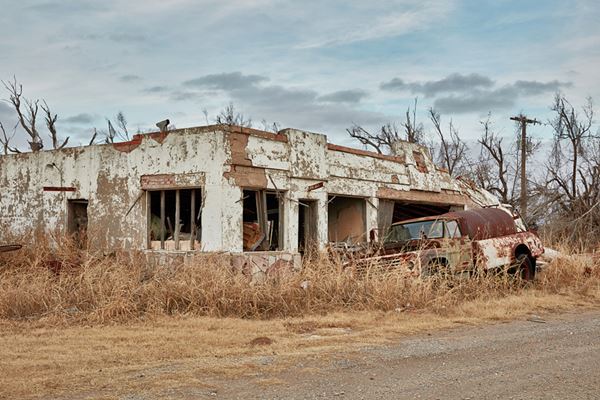
Hinton Junction Cafe and Courts.
Index to this page
About Bridgeport, Oklahoma
Facts, Trivia and useful information
Elevation:1,503 ft (458 m). Population: 96 (2024).
Time zone: Central (CST): UTC minus 6 hours. Summer (DST) CDT (UTC-5).
Bridgeport is located on the northern border of Caddo County, to the north, across the Canadian River lies Blaine County. Route 66 and I-40 pass to the south of the town.
This region has been inhabited for over 10,000 years, but the current mix of Native Americans is the outcome of migrations and relocations that began in the 1700s.
Cheyenne & Arapaho
The Arapaho lived in Montana, Wyoming, South Dakota and southern Canada, and the Cheyenne lived near the Great Lakes in Minnesota, moving later towards the Great Plains (1700s.).
Soon both nations formed an alliance and hunted in a territory which spanned from Texas to Montana. A Treaty with the U.S. government (1868) guaranteed the integrity of their traditional lands but soon European settlers entered the area leading to conflict and war.
The natives were later assigned a Reservation near Fort Reno in what would become Oklahoma (1867).
This would change when then the US Congress organized the Oklahoma Territory from land formerly ceded to Indian Nations. The U.S. government distributed part of the land of the Reservation among the tribe members (160 acres each) and bought back the surplus, which was later opened to settlement during the "Cheyenne-Arapaho Opening" in April 1892.
The name Bridgeport
Its name derives from the spot used for crossing Canadian River, just north of the town. It could be crossed at low-water on horse back, or ferried across it during the high water period.
Cheyenne Arapaho Opening
3.5 million acres of "surplus" land was opened for settlement by the U.S. government on April 19, 1892. Settlers rushed to claim their 160-acre homestead plot.
By the end of the "opening", only 20% of the land had been claimed and only 7,600 people had settled there. The region at that time was going through a severe dry spell (1885-1896) which hurt the crops. There were no railways to ship the produce to the markets.
The rural community was established in 1895 at a strategic ford across Canadian River. The original town started in 1901 as a federal townsite, and it incorporated in 1901.
The Choctaw Railroad (later the Chicago, Rock Island, and Pacific Railroad) built a line from Oklahoma City and passed through the town, but the community declined paying the insurance so the railway did not build switches near the town until later. This led to a drop in the population, which shifted to other nearby towns. A second railway passed through the town in 1902.
Cotton production was the mainstay of the local economy. And by statehood in 1907 it boasted 462 residents, which began to decline during the 1920s.
In 1926 Route 66 was aligned through the town using the 1921 private toll bridge built across the Canadian River, but the upgrade during 1931-34 moved the road further south, bypassing it for good.
The Great Depression hurt farmers and population dwindled. The once thriving community is now almost a ghost town with some residents.
It was, and still is, a rural community based on farming. The original alignment of Route 66 only passed through it between 1926 and 1934, when it was shortened and aligned further south, bypassing it.

Getting to Bridgeport
Heading east from Bridgeport down Route 66 are the towns of: Geary (10 mi.), Calumet (21 mi), El Reno (26 mi.), Yukon (40 mi.), Oklahoma City (55 mi.), and Edmond (66 miles).
To the west, are Hydro (11 mi.) and Weatherford, 18 miles.
Where to Stay; find your hotel
Book your hotel close to Bridgeport in neighboring El Reno (26 mi east).
> > Book your Hotels in El Reno
Lodging Near Bridgeport along Route 66
There are several hotels in the area close to this town. Alternatively you can also find your accommodation along Route 66 in the neighboring towns and cities. We list them below (listed from east to west):
On Route 66's Main alignment
Eastwards
Westwards
>> There is an RV campgrounds in Bridgeport.
Weather in Bridgeport
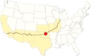
Location of Bridgeport on Route 66
The average high in summer (July) is 93°F (34°C); the average low is 69°F (21°C). The average high in January (winter) is 46°F (8°C), and the average low is 26°F (-3°C).
The yearly rainfall is around 28.7 inches (729 mm). Most rain falls during May and June with over 4 in each (100 mm).
There are about 89 wet days every year. Important: Thunderstorms are frequent during late spring and summer, with hail, heavy rain, strong winds and, sometimes tornadoes.
Snow may fall between November to March: 9.6 inches of snow (24 cm) per year.
Tornado risk
Bridgeport is located in Oklahoma's "Tornado Alley and experiences about 11 Tornado watches every year.
Tornado Risk: read more about Tornado Risk along Route66.
Map of Route 66 through Bridgeport Oklahoma
Below is a map published in 1931; part of the alignment was paved (solid red line), the rest was an "All-weather road" unpaved. Notice the word "Bridge" above Bridgeport, it marks the old toll-bridge.
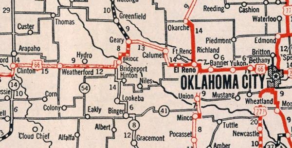
This 1926 alignment was bypassed when the Pony Bridge was built east of Bridgeport, and linked Hydro with El Reno via Bridgeport Hill in 1934, cutting off Bridgeport, Geary, and Calumet from Route 66.
This new alignment paved in Portland cement was aligned to the south of the town of Bridgeport as you can see in the following map.

1957 map of Bridgeport and US66 Click to enlarge. Source
The thumbnail map (click on it to enlarge) was published in 1957, before I-40 was built in this area. You can see Bridgeport (spelled incorrectly as "Brideport"), US 66 running from left to right. The "tourist cours" are marked with the black triangles inside a rectangle. The black squares and rectangles are "dwellings" and the L-shaped forms are "small business". Clearly the town had spread along the highway Notice the motels in Hinton Junction and the future I-40 (dotted double line).
Look for Bridgeport on our Oklahoma Route 66 Map, with the complete alignment and all the towns along it.
The Old alignment of Route 66 near Bridgeport
See this Route 66 alignment map in Bridgeport.
This the intact 1931-34 alignment of Route 66 that runs from Bridgeport Hill, past Hinton and Bridgeport to Hydro. It was paved in Portland Concrete in 1931, 33 and 34. It is the current alignment of OK-66. It remained operational as US-66 until 1962 when I-40 replaced it and became the new roadbed for US-66 till its decertification.
Route 66 Alignment near Bridgeport
With maps old maps and all the details:
- Clinton to Texola (next)
- Yukon to Clinton (Bridgeport's)
- Chandler to Yukon (previous)
Route 66 landmarks & attractions
Sights in Bridgeport
- In Bridgeport - read below
- Nature, Outdoors, and Parks
Bridgeport Attractions
Jack DeVere Rittenhouse described the whole of US 66 in his "Guide Book to Highway 66", published in 1946. He drove the whole highway from Chicago to L.A, and he described Bridgeport.
HINTON JUNCTION... at the junction is a large roadside park with several tables, fireplaces, and water. Nearby are a cafe, gas station, garage, and two small courts. Just west on US 66 is Leon Little's cafe with gas and a few cabins...
BRIDGEPORT.. small town about one mile off US 66... at the junction... are several gas stations and three tourist cours: Yount's, Guy's and Harvey House Jack DeVere Rittenhouse, 1946
We will begin our tour on the eastern side of Bridgeport, coming from El Reno, at the point where the "El Reno Cutoff" began and is the starting point of the Historic Route 66 segment that ends in Hydro.
Bridgeport Hill - Hydro Segment of Route 66
Old Route 66 Bridgeport Hill to Hydro, Geary to Hydro, OK.
Listed in the National Register of Historic Places
One of the longest intact segments of the original Route 66 roadbed and roadway in western Oklahoma: 19.5 miles long.
This segment begins at Bridgeport Hill, and heads west all the way to Hydro. It was paved in Portland Concrete in 1931, 33, and 34 and remained operational until 1962 when I-40 replaced it.
As you turn off US 281 sour, to your right you will see a historic service station.
Bridgeport Hill Service Station
Listed in the National Register of Historic Places
On the eastern side of Bridgeport Hill. It was built by Leroy Tiller in 1934. It was renown because it was set at the top of a long steep slope that climbed out of the Canadian River Valley to the west.
The station and store is a "house and canopy" style station, with with a metal gable roof that extends over the pump island from the small building. On the left is a long rectangular garage and next to it, to the right is the well house, a concrete block building with an inscription on it "Drilled by Leroy tilley, October 12, 1934, Depth 77 ft."
When I-40 opened in 1962, Route 66 was realigned along it, bypassing the station.
Bridgeport Hill
The road now follows a long incline called Bridgeport Hill, descending towards the west. For those heading east, this long incline was tough to tackle in 1930s cars and trucks.
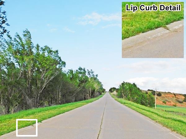
Lip Curbs
As concrete surfaced roads were new at that time, roadbuilders experimented. The highway had a normal edge that blended into the shoulder if the terrain was flat and level. However, when there was an incline or grade, they added "Lip Curbs".
These were sloping, curved, curbs, not the usual 90° ones. The idea was to contain any water that fell on the highway when it rained and not let it soak into the shoulder, it was conducted downhill along the edge of the highway and then drained at specific points through channels into a ditch.
These lip curbs had an unexpected consequence: they were hazardous; vehicles could flip over if they hit the curbs. So they were not included in later highway construction.
Below is a detail of how they were built.

Ancient Roadbed
At the foot of Bridgeport Hill, Route 66 turns left along what is now US 281. On the SE corner of the junction you can see the original roadbed of Route 66.
It is a strech of road 300 ft (100 m) long and It can be accessed from either highway just 200 ft. short of the junction. After this point, US66 took a SW course heading towards the Canadian River River
Visit the old Toll Bridge remains
Suspension bridge pylons. It carried US66 from 1926 to 1934
You can take a short detour, a 8.6 mi. roundtrip (map with directions) along dirt roads -check if they are in good shape before you go.
The Toll Bridge at Bridgeport
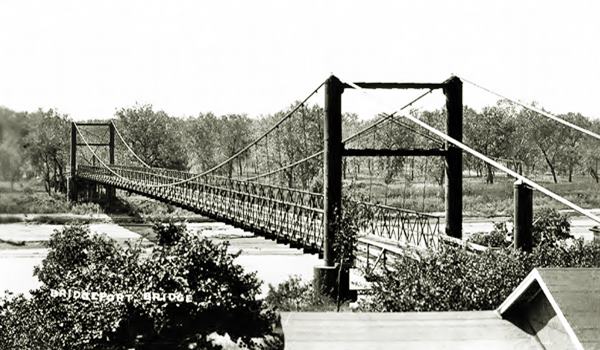
There were many private toll bridges on Oklahoma state highways, like those on the Red, Grand and Canadian rivers. This bridge was built by Oklahoma City businessman George Kay in 1921. The toll was quite expensive
($1.00 for cars and $1.50 for trucks).
The suspension bridge was held up by cables, anchored on both shores and held up by steel pylons, two of them have survived and stand on the north side of the river.
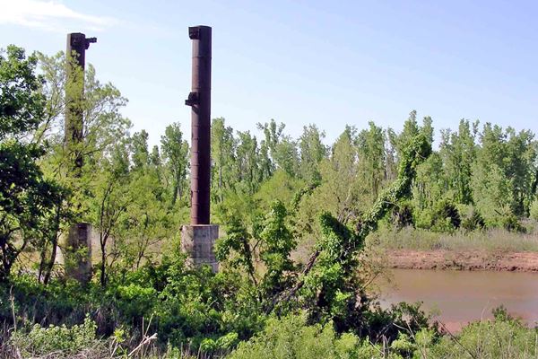
It was used by the Ozark Trail and Postal Route from Geary into Bridgeport, and in 1926 Route 66 was aligned along this highway.
The expensive toll and the fact that the Route 66 was being paved and realigned sealed the fate of this bridge. In 1934 the new alignment "El Reno cutoff" bypassed the old toll bridge using the "Historic Canadian River Bridge" further east.
You can follow the original Route 66 alignment across the river using the toll bridge and into Bridgeport in the following map; it is marked with a violet line. This is now abandoned, in private property and cannot be driven. The final segment into Bridgeport and through it, is shown in this map. This alignment was replaced by the one through Hinton Junction in 1934, bypassing the town of Bridgeport.
From Bridgeport Hill into Hinton Junction
Head back to the 1934 Route 66 alignment and turn south. You will cross the Canadian River along the 1934 "Pony Bridge" and continue driving along the historic segment of Route 66.
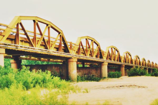
Historic Canadian River Bridge
Historic bridge
Old Route 66 and Canadian River, Geary, OK.
The longest truss bridge in Oklahoma and of the whole Route 66, built in 1934.
The bridge's official name is "William H. Murray Bridge", but it is also know as the "Pony" bridge. William Henry Davis "Alfalfa Bill" Murray (1869 - 1956). Was the first Speaker of the Oklahoma House of Representatives after statehood. A U.S. Representative, and the ninth Governor of Oklahoma (1931-1935).
Below is a 1930s photo looking north along Route 66 towards the Canadian River, bridge can be seen in the distance. Click on the image to see the same view nowadays.
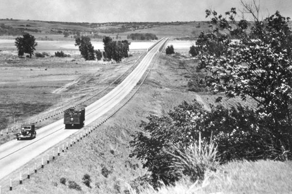
It is the longest bridge on Route 66 and measures 3,944.33 feet long, roughly 3⁄4 miles (1,203 m.
It was built by the Kansas City Bridge Co. and opened to traffic in 1934 after delays and litigation trying to halt its construction as it would bypass the town of Bridgeport. It cost $346,000 which is roughly 6,9 M$ nowadays.
The bridge has 38 pony truss sections, a "truss" is the steel structure made up of triangles that supports the bridge on either side of the deck. Each truss measures 100 feet long.
They are called Pony because the top of the bridge is not joined together with cross braces.
The trusses have a "Camelback" design because the truss curves with a slight arch-shape; this is both strong and light.
It was finally opened to traffic in 1934 due to delays in the Bridgeport section of US 66.
Historic Canadian River Bridge, on US 66 approaching Bridgeport
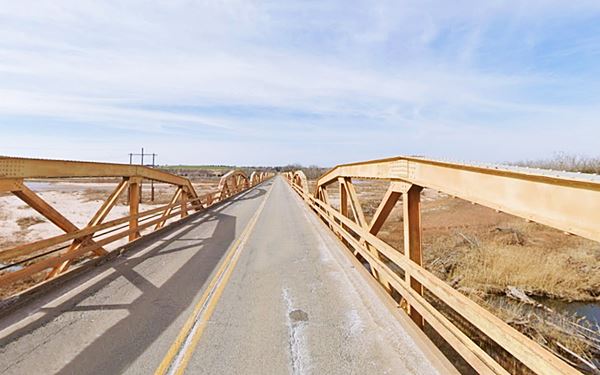
"Pony" Bridge Trivia
The western tip of the Canadian River Bridge appeared in the award wining movie "Grapes of Wrath" filmed in 1940. It was the scene where "Grandpa" died and was buried.
The highway climbs out of the valley and turns rigth, with a east to west course. Just ahead it meets State Highway 8, and US 281 at "Hinton Junction".
Hinton Junction
Named so because the town of Hinton is located 4.5 miles south along US 281. It was born when US-66 bypassed Bridgeport in 1934. The town lived off traffic going through it and the new alignment ran 0.7 miles south of it.
Bridgeport residents moved out and set up their businesses along the new Route 66, some moved to where Hinton Junction is, others to the outskirts of Bridgeport, along Route 66.
Not much remains of the cafes, gas stations and tourist courts that were built at the junction. The first building is a former Cafe and service station.
Little's Cafe and Service Station
Wilbur Leon Little (1911-1994) married Ann Ondracek (1914-2006) in 1932 and bought a gas station next to the suspension bridge on Route 66 in Bridgeport. When traffic moved away in 1934 they moved too. He opened a new station on the brand new highway at the junction of US 66 and OK-8. He named the place Hinton Junction.
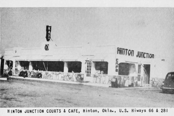
Below is a 1940s view of the "Hinton Junction Courts & Cafe". Gas pump can be seen on the far left and an arrow pointing down with the word "EAT" crowns the middle of the building.
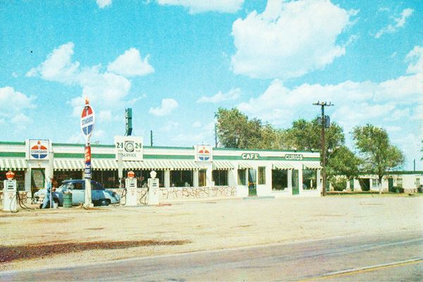
Below is a color postcard from the 1950s, you can see the motel on the right side, the Standard gasoline signs, the green "EAT" sign, and a "Curios" sign to the right. The postcard reads "Modern Cafe, fully air conditioned, ten modern cabins with individual air conditioning and television."
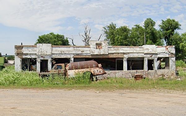
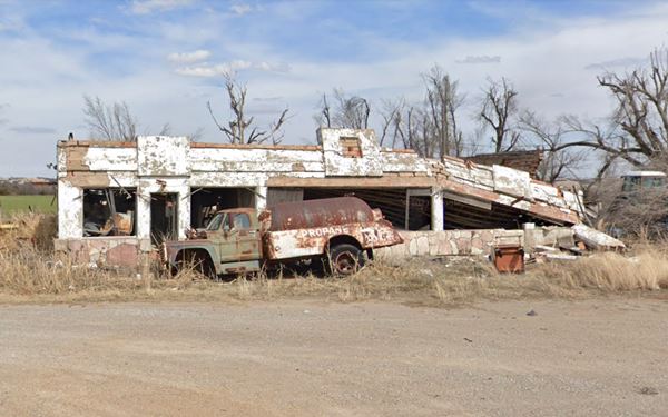
Now the place is falling apart, collapsing, ruins that will soon be razed, below are two views showing its decay, one from June 2019, the other March 2021, maybe the next time we update this page we will add a third view, with an empty piece of land.
Old gas station in ruins, Bridgeport (2019)
Old gas station in ruins, Bridgeport (2021)
Ahead is the Prk mentioned by Rittenhouse, in the "Y" junction with US-281, with tables and trees, see a street view. After the junction, to your left was Little's third gas station and second motel.
Little's Modern Court and gas station
As business grew Leon expanded and in 1940 built another cafe, a two-story gas station, and a motel on the western side of Hinton Junction (the one mentioned by Rittenhouse in 1946), to cater to the eastbound traffic.
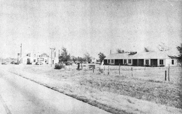
The motel was located on the SW side of the property, a long, one-story gable roof building with eight units. The postcard said "Leon Little's Modern Court, Station and Cafe".
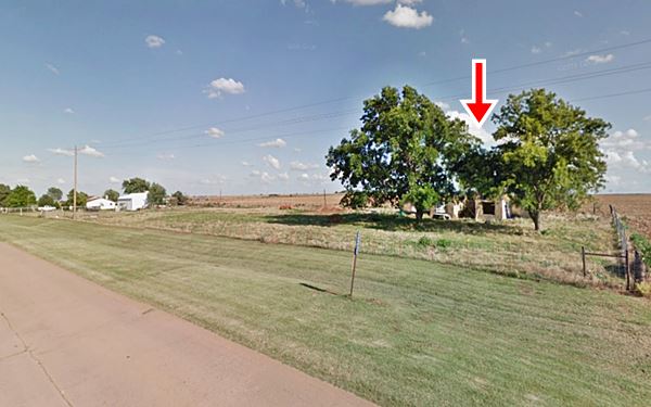
The "Then and Now" sequence below is looking east towards Hinton Jct., the motel and station are on the south side of the higway. The motel units are on the right, and the gas station on the far left. In the modern view, the remains of the court are behind the trees (red arrow)
The postcard below, postmarked in 1948 shows a view looking towards the southwest of "Frazier's Cafe, at Leon Little's station and Modern Court", the Cafe is on the left and the station that sold Phillips 66 is on the right (with a Cafe and Coca Cola sign) on the two story building. All of these buildings have gone.
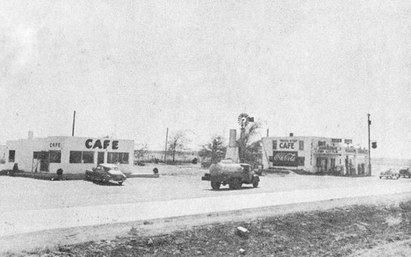
The highway heads west, across a relatively flat countryside cut by streams. After Graceland Cemetery, roughly 0.8 mi west of Hinton Junction you will cross a steel Stringer bridge built in 1934. There are bronze "FAP" (Federal-Aid Program)highway markers embeded in the concrete end posts of the bridge. (Street view).
Bridgeport the Ghost Town
Continue west for 1 mile and you will reach the entrance into the "ghost town" of Bridgport, to your right. Here is where the 1926-34 Route 66 alignment coming from the old suspension bridge turned west and headed towards Hydro.
In this area at the "Y" junction were more stores, cafes, gas stations and tourist courts.
If you drive into Bridgeport, these are its only two sights:
The 1907 Church
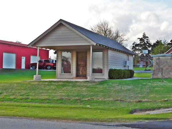
On the southeast corner of Broadway and Market St. The First United Methodist Church of Bridgeport was built in 1907 and, unlike many buildings in town, is in very good condition and is still in use.

Church, Bridgeport. Source

The post office in Bridgeport. Source
Old Post Office Building
On the east side of Market St. between Wichita Ave. and W. Broadway. A simple tin sheet roofed building slowly decaying.
Head back to Route 66.
Harvey House station and motel

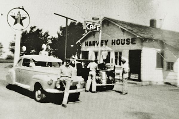
Harvey House Texaco 1940s, Bridgeport. Source
Like Leo Little, Harvey Perry Wornstaff (1880-1966) also owned a service station on Route 66 by the Suspension bridge (his was on the north side of the river), in 1934 when it was bypassed by the new alignment he too moved to it.
He opted for the "Y" at Bridgeport and relocated the gas station on the NE side of the junction, he called it "Harvey House".
He ran it, added a restaurant and a tourist court on the right side of the property, a small motel.
Rittenhouse mentioned it in 1946.
Could the name of Harvey Wornstaff's business have been inspired by "Harvey Houses"? These were the creation of Frederick Henry "Fred" Harvey (1835 - 1901) an entrepreneur who developed the concept of efficient and clean service plus good qualtiy food for those travelling by rail in the old "wild west". His restaurants were known as "Harvey Houses".
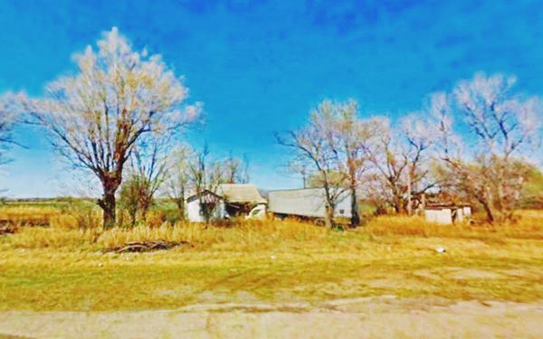
Now there is an RV campground here, Territory Route 66, operated by the family who lived here! a great way to preserve Route 66's heritage and memories.
There were other businesses along Route 66 here in Bridgeport: the Yount's (Velma and Ray), were mentioned by Rittenhouse, and had a gas station with a restaurant. Guy had a tourist court, D. Lee a gas station and Nancy Rose ran a grocery store and sold gas.
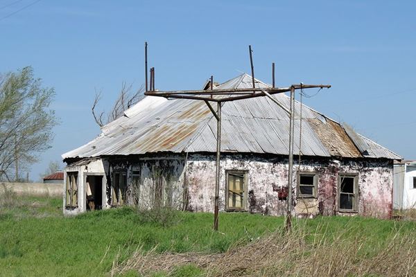
This marks the end of your city tour along Route 66 in Bridgeport, you can go west and visit neighboring Hydro.
Natural Attractions
Red Rock Canyon Adventure Park
Just 9.7 miles SW of Bridgeport along US 281. See this map with directions.
Visit the 80 feet high red canyon walls: rappelling is one activity, as well as fishing, hicking, rock climbing and swimming. The park was a stop along the "Historic California Trail" of the 1800s pioneers.
RV facilities with hookups and also primitive sites. Camping allowed too. Learn more at the official website.
Some sponsored content
>> Book your Hotel in Tulsa

Credits
Banner image: Hackberry General Store, Hackberry, Arizona by Perla Eichenblat
Jack DeVere Rittenhouse, (1946). A Guide Book to Highway 66.
Cynthia Savage, Bridgeport, Encyclopedia of Oklahoma History and Culture, www.okhistory.org
Jim Ross Historic US 66 Bridge Database 1926-85
Bridgeport Hill - Hydro Route 66 Segment, NPS historic site registration form
Bridgeport Hill Service Station, NPS historic site registration form


