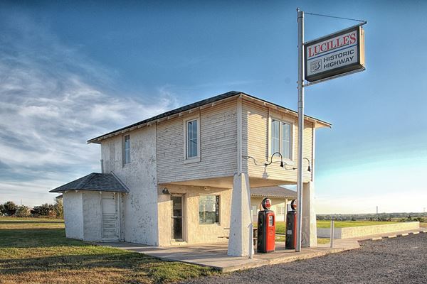
Site of Lucille's Place
Historic "Provine Station" also called "Lucille's Place"
Index to this page
About Hydro, Oklahoma
Facts, Trivia and useful information
Elevation: 1,555 ft (474 m). Population: 969 (2010).
Time zone: Central (CST): UTC minus 6 hours. Summer (DST) CDT (UTC-5).
Hydro is located on the northwestern tip of Caddo County, to the north, across the Canadian River lies Blaine County, and part of the town extends into it. Route 66 and I-40 pass to the south of the town.
This part of Oklahoma has been inhabited for over 10,000 years but its Native American population is the result of migrations that took place after the mid 1700s.
The Caddo and Wichita
The Caddo were an agricultural society that lived in eastern Texas, southern Aransas, southeastern Oklahoma and western Louisiana. European settlement forced them west and finally they were relocated in Oklahoma.
The Wichita (also known as Washita, Wichita, and Ouiehita) lived in Oklahoma and Texas, but in 1859 they were forced to a Reservation in Oklahoma, then relocated near what is now Wichita in Kansas and finally moved back to another Reservation in Oklahoma (1867).
The Wichita Caddo Delaware opening was a land lottery which took place in 1901 on the surplus land that had once been part of the Indian Reservation. 164,000 homesteaders had registered to the draw for 13,000 plots of 160 acres each. The lucky ones whose name was drawn, then proceeded into the territory to stake their claims.
The Dawes Act of 1887 laid down the law that was used in 1891 to reach an agreement with the Natives for their land: each tribe member received a 160-acre plot and the surplus was purchased by the U.S. government for future use. However there was resistance to this allotment and the matter ended up in court. The Supreme Court finally settled the issue one decade later.
After the Wichita and Caddo Reservation opened to settlement, the town was founded on August 6, 1901. It was initially named after the Indians, "Caddo", but when the post office was set up the following month, it changed the name to "Hydro". It was built near the Choctaw, Oklahoma and Gulf Railroad's tracks.
"I County" was the initial designation of the area, which changed to Caddo County on November 8, 1902.
Hydro, the name
The abundant water provided by the town's well suggested the name "Hydro" from the Greek word for "Water"
The town was a rural community based on corn and cotton as well as livestock; the first school in Caddo County opened in Hydro. The Church which is still in use, was erected in 1907.
In 1926, Route 66 was created and it ran past the southern side of the town, which benefited from its increasing flow of traffic, as drivers stopped to refuel or eat in the town.
During the Dustbowl and the Great Depression, population declined as farmers were forced off their lands by failed crops or debt. During that period, the Works Progress Administration paved Hydro's streets and built the present schoolhouse and community center.
Getting to Hydro
Heading east from Hydro down Route 66 are the towns of: Bridgeport (11 miles), Geary (21 mi.), Calumet (32 mi), El Reno (37 mi.), Yukon (51 mi.), Oklahoma City (66 mi.), and Edmond (77 miles).
To the west, are Weatherford, 7 miles, Clinton (23 mi.) and Foss (37 mi.)

Where to Stay? Find your hotel
Book your hotel in neighboring Weatherford
>> Book your Hotels in Weatherford
Lodging Hydro along Route 66
There are several hotels in the area close to this town. Alternatively you can also find your accommodation along Route 66 in the neighboring towns and cities. We list them below (listed from east to west):
On Route 66's Main alignment
Eastwards
Westwards
>> There are RV campgrounds close to Hydro.
Weather in Hydro

Location of Hydro on Route 66
Temperature: during summer (July) the average high reaches 93°F (34°C) while the average low is 69°F (21°C).
During winter (January) the average high and low are 46°F (8°C) and 26°F (-3°C).
Rainfall is around 28.7 inches per year (729 mm) with May and June being the rainiest months with just over 4 inches each (100 mm).
There are some 88 wet days per year. Thunderstorms are more frequent during late spring and summer and may cause hail, heavy rain and strong winds. Sometimes they provoke tornadoes.
Snow can fall at any time between November to March and averages around 9.6 inches of snow (24 cm) per year.
Tornado risk
Hydro is located in the "Tornado Alley and experiences about 12 Tornado watches every year.
Tornado Risk: read more about Tornado Risk along Route66.
Map of Route 66 through Hydro Oklahoma
Check out Hydro on our Oklahoma Route 66 Map, with the complete alignment and all the towns along it.
The map below, published by the USGS in 1964, shows Hydro and Route 66 with I-40 running left-to-right. At that time the "old" 2-lane Route 66 formed the westbound lanes of the freeway. The eastbound lanes of I-40 & US66 would late become the westbund lanes of I-40 when it was improved and became a limited access expressway. Notice in the image that there are no overpasses there are no "grade-separated intersections".
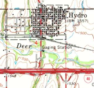
The Old alignment of Route 66 near Hydro
See this Route 66 alignment map in Hydro.
Hydro marks the western terminus of the intact 1931-34 alignment of Route 66 that runs from Bridgeport Hill, past Hinton and Bridgeport.
This segment begins just west of the South Canadian River bridge and heads west all the way to Hydro. It was paved in Portland Concrete in 1931, 33 and 34. It is the current alignment of OK-66. It remained operational as US-66 until 1962 when I-40 replaced it and became the new roadbed for US-66 till its decertification.
US 66 west of Hydro
Route 66 west of Hydro has followed the same alignment since 1926. It was paved in Portland Concrete all the way to Custer Co. line and from there into Weatherford in 1931. It remained a 2-lane road until 1959 when Route 66 was upgraded to a 4-lane road (see map above).
Route 66 Alignment near Hydro
- Clinton to Texola (next)
- Yukon to Clinton (Hydro's)
- Chandler to Yukon (previous)
Route 66 landmarks & attractions
Sights in Hydro, city tour
After driving Route 66 in 1946 Jack DeVere Rittenhouse described the whole of US 66 in his "Guide Book to Highway 66". He mentioned Hydro.
Road right to HYDRO. about a mile off US66 (Pop. 759; ALT. 1,475'; Kirk's Court). Jack DeVere Rittenhouse, 1946
One mile west of the town he encountered Lucille's Place and described it: "Two small tourist courts here", followed one mile west by another gas station.
The two tourist courts (or motels) were Kirk's and Hamon's.
We will begin our tour starting on the eastern side of town, coming from Bridgeport and head west. The first landmark is a former gas station that looks very similar to Lucille's.
Old Gas station
Just 0.2 mi. west of Count St. 2500, to your right is a two story gable roof home. It has a concrete driveway leading to a parking area under the second floor, which extends over the open bay beneath it. Built in a Craftsman-Bungalow style, with two solid pillars holding up the second floor.
There may have been a pump island between both pillars. Its style is identical to the Provine Station - Lucille's place, further ahead, in Hydro.
You can see it in this 1955 aerial photo on the upper part of the image, notice the truck heading east along US 66. Below is a street view of the building (notice the driveways on each side).
Two 1930 US 66 bridges
As you head west, you will cross two original Route 66 bridges, the first one is a single span steel truss bridge built in 1930 (date stamped in the concrete abutments), it carries Route 66 across the Cedar Canyon Creek. (street view), followed 0.5 mi. west by another 1930 steel Stringer bridge with concrete guardrails. See image above.
Deer Creek Flash Flood
On June 23 and 24, 1948 eleven people died due to a flash flood of the Little Deer Creek. A sudden rainfall released 20 inches of rain in the area.
Those that died were caught in a car and a Greyhound cross-country bus that according to the newspapers at that time "became maroond on U.S. Highway 66 near Hydro", 100 cars were trapped by the water, a local resident "reported his automobil was washed off the highway as he drove west from Hydro to Weatherford... Mrs. Scarlett was riding with him. She is missing."
At the entrance to Hydro, you can take a right to visit the small town.
Main Street, Hydro, Oklahoma
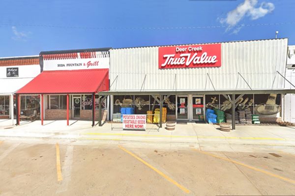
A Classic Main Street
The town's Main Street is typically that of a "Small Town" in the American Mid West. The Route 66 Soda Fountain (shown in the image above with the red awning) is a vintage place that will take you back in time.
On the same block is Nutopia (Johnson Peanut Co.), established in 1942, which sells every kind of peanut item you can imagine from candy to oil to spicy peanuts.
The two story brick building on the NE corner has a Freemason symbol as a frieze on its parapet (street view), it reads AF & AM (Ancient Free and Accepted Masons Lodge) and the number 230, with the compass.
Return to Route 66 and turn right and head towards Weatherford to visit Hydro's best known attraction.
Provine Service Station ("Lucille's Place")
Listed in the National Register of Historic Places
It is half a mile west of US 58 intersection with I-40 (Exit 88) along Route 66, at OK-66 and S. Coleman Ave, Hydro, OK.
An iconic service station that served customers along Route 66 from 1929 until 2000.
This two-story service station wasy built by Carl Ditmore in 1929. It was conveniently located half a mile south of Hydro on Route 66 (which had been created only three years earlier).
It had living quarters on the upper floor, and was built in a local variation of the "Bungalow Craftsman" style. It has a hipped roof with wide overhanging eaves. The second-story projects towards the front of the building and covers the service bay. Its weight is supported by massive tapered columns.
Ditmore sold it to Carl Ethel shortly after (July 1929).
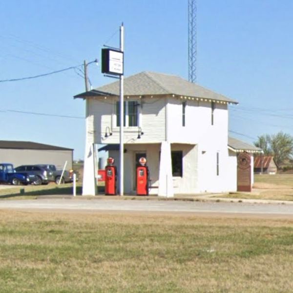
In 1934 Oscar Waldroup and his wife Ida purchased the station and changed its name to Provine Service Station although we don't know why. The Waldrups were from North Carolina, and there is no town or county named Provine there... a mystery.
They added some tourist cabins behind and to the east of the station, which became a five-room motel.
Carl Hamons (1909-1971) and his wife Lucille Ione Hamons née Arthurs (1915-2000) acquired it in 1941 and renamed it "Hamons Station". While Carl drove a truck, Lucille ran the station.
Carl and Lucille divorced in 1964 and she and continued running the station. Se earned the nickname of "Mother of the Mother Road" and was the reason for Provine Station to be commonly known as Lucille's Place.
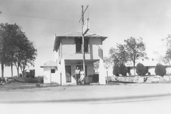
In the image below, there aren't any gas pumps on the island, it was taken in 1941, when the Hamonds bought the place.

1970s photo Lucille's Conoco station. Source
Some time during the 1960s she switched from Phillips66 to Conoco gasoline. Shortly after, I-40 was finally completed in 1965, when the traffic using the safer and quicker expressway bypassed the station.
Lucille closed the motel in the 1980s and kept operating the station a few more years. To increase her income, Lucille also sold cold beer which the locals from nearby Weatherford -a dry town- found very appealing.
When the "Hamond Court" sign blew down, she replaced it with the current sign. Lucille passed away on August 18, 2000.
The Hamons Court motel sign

Hamons Court Motel Sign, 1941. Source
The original sign was donated by the Hamons family to the Smithsonian National Museum of American History in 2003. It is part of the exhibition on "America on the Move". The sign was made in 1945 in sheet metal with neon lighting. It is 87 x 42 x 12 inches (221 x 107 x 30 cm).
Route 66 Marker
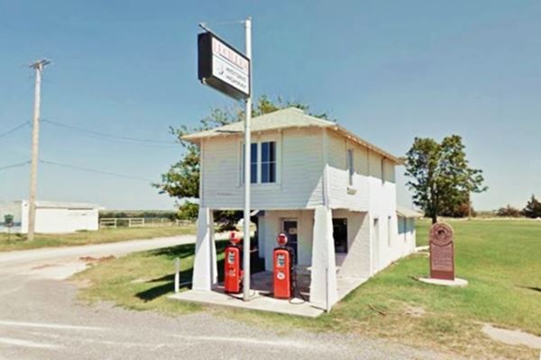
On the eastern side of the property is the "Provine ⁄ Hamons' Station" red granite marker. It tells the story of the property and of Lucille. You can see it to the right in the following image.
Lucille's Place - Provine Service Station and marker, Route 66, Hydro, Oklahoma
Hilltop Cafe
On the NW corner of Route 66 and S. Coleman Avenue. The original building (2013 Street view) was torn down.
Kirk's Texaco, Café and Motel
Mentioned by Rittenhouse in 1946 (Kirk's Court) it was located across Route 66 from the Provine station, on the south side of the highway.
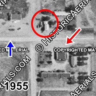
It did good business until it was torn down when I-40 was built. The following aerial photograph taken in 1955 (courtesy of historicaerials.com)shows the three businesses at S. Coleman and Route 66 at that time.
The red circle marks Lucille's Place. You can make out the hipped roof. The blue arrow marks the roadbed of Route 66, that runs across the image from left to right. The red arrow shows where Kirk's Motel was located, on the south side of US66. You can make out its L-shaped layout, with the Cafe in the middle. Hilltop Cafe is on the NW (upper left) corner of Route 66 and S. Coleman Ave. (above the blue arrow). Notice the cabins to the left of Lucille's Place.
In the other image, a modern satellite photograph, Lucille's and Route 66 are still there (red circle and blue arrow), but Kirk's Motel has gone, now the freeway's road margin occupies that space; just grass.
This marks the end of your city tour along Route 66 in Hydro. Head west to visit neighboring Weatherford
Ghostly Mounds
To the south of Hydro are several small hills on an otherwise relatively flat area. They are the "mounds"; some of them have been named. They are natural and are known as "Antelope Buttes", "Hydro Mounds" or "Caddo Mounds".

Dead Woman Mound, Hydro. Source
"Dead Woman Mound" (1,700 ft.) received its name after a pioneer found the body of a woman buried at its foot. "Ghost Mound" is 9 mi. south of Hydro, and was an Indian ceremonial site. See its Satellite view.
Hydro Mound Trivia
American author of horror, fantasy and science fiction, H. P. Lovecraft (1890 - 1937) ghostwrote a story, "The Mound", for Zealia Bishop which was set in Caddo Co. and tells about an Indian mound haunted by a headless ghost. It was published in 1940.
Lt- James H. Simpson recorded the mounds in 1849, as he escorted gold seekers to California. Whipple's Expedition in 1853 also described them. Rock Mary can be seen in this Satellite view.
Some sponsored content
>> Book your Hotel in Tulsa

Credits
Banner image: Hackberry General Store, Hackberry, Arizona by Perla Eichenblat
Jack DeVere Rittenhouse, (1946). A Guide Book to Highway 66.
Ramona Armstrong Duff, Hydro, Encyclopedia of Oklahoma History and Culture, www.okhistory.org
Jim Ross Historic US 66 Bridge Database 1926-85
1948 Hydro Flood


