Route 66 in the Heart of Oklahoma
Index to this page
About Weatherford, Oklahoma
Facts, Trivia and useful information
Oklahoma's Space Town
Elevation: 1,654 ft (504 m). Population: 11,994 (2025).
Time zone: Central (CST): UTC minus 6 hours. Summer (DST) CDT (UTC-5).
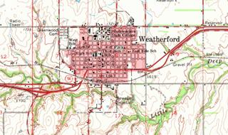
Weatherford is located in southeastern Custer County in western Oklahoma.
This area has been inhabited for over 10,000 years, and its current Native American population was relocated there after the early 1800s by the U.S. government, when it created the Indian Territory to settle the natives that lived east of the Mississippi River in exchange for their original territories. Reservations were established and the Indians forcibly moved to them.
Cheyennes & Arapahos
The Cheyenne lived near the Great Lakes in Minnesota and moved towards the Great Plains in the 1700s. The Arapaho lived in Montana, Wyoming, South Dakota and Canada. Both nations met in the plains and formed an alliance whose territory ranged from Texas to Montana. Despite signing a treaty with the U.S. government (1868) which guaranteed the integrity of their traditional lands, European settlers intruded on their territory. This caused conflict. A second treaty was signed (1867) promising the Arapaho a Reservation in Kansas, but they opted to move with the Cheyenne to a reservation next to Fort Reno.
The Dawes Act of 1887 changed the U.S. government's policy: the natives had to be assimilated. So in 1891 the reservations were dissolved: each tribe member received a 160-acre plot and the surplus tribal land was purchased by the U.S. government for future use.
Cheyenne Arapaho Opening
3.5 million acres of land were opened for settlement by the U.S. government on April 19, 1892. The settlers flocked to the Oklahoma Territory to claim their 160-acre homestead plot. This land had been part of the Arapaho-Cheyenne Reservation.
By the end of the "opening", almost 80% of the land remained unclaimed, and by 1892 only 7,600 people had settled there. The area at that time was going through a terrible drought (1885-1896) and crops failed giving the farmers a very bad time. Furthermore there were no railways to get the produce to the markets.
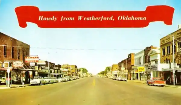
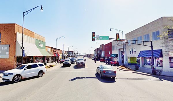
The post office was built in 1893 on William J. and Lorinda Powell Weatherford's homestead, about 2 miles north of the current townsite. Lorinda was the first postmistress
The town incorporated in 1898 and its population reached 1,017 residents in 1900.
Weatherford, the name
The town was named after a homesteader, William Weatherford who was also the US Territorial Marshal.
The town's economy was based on wheat, maize and cotton farming. The Choctaw, Oklahoma and Gulf Railroad (later part of the Chicago, Rock Island and Pacific Railway) reached the town in 1898 and linked it to the world.
Weatherford was chosen by what is now Southwestern Oklahoma State University for its campus in 1901 and in 1926 its Main Street was incorporated into U.S. Route 66's alignment. Though the Great Depression hit the farmers, the town recovered and is now fairly industrial. Its airport is named astronaut for Gen. Thomas P. Stafford, a Weatherford native and houses a museum.

Where to Stay: Hotels
Book your hotel in Weatherford
>> Book your Hotel in Weatherford
Lodging Near Weatherford along Route 66
There are several hotels in the area close to this town. Alternatively you can also find your accommodation along Route 66 in the neighboring towns and cities. We list them below (listed from east to west):
On Route 66's Main alignment
Eastwards
Westwards
>> There is a RV campground in Weatherford.
Weather

Location of Weatherford on Route 66
The weather in Weatherford (pun intended): The summer (July) average high temperature is around 93°F (34°C) and the average low is 69°F (21°C).
The winter (January) average high is 46°F (8°C) and the low is around 26°F (-3°C).
Rainfall is about 28.6 inches per year (726 mm). May and June are the rainiest months with just over 4 inches each (100 mm).
There are around 88 rainy days per year and thunderstorms are more frequent during spring and summer. They cause hail, strong winds and may provoke tornadoes.
Snow falls during winter and averages about 9.6 inches (24 cm) per year.
Tornado risk
Weatherford is located in the "Tornado Alley and experiences about 12 Tornado watches every year. Tornado Risk: read more about Tornado Risk along Route66.
Map of Route 66 in Weatherford, OK
Route 66 had different alignments across Weatherford over the years.
>> Custom map of Route 66 through Weatherford.
Click on the thumbnail image to see Route 66 in Weatherford in 1964.
- From 1926 to 1930. US 66 it entered Weatherford along E. Davis, turned south (left) along Washington and ran west along Main St. all the way to 4th. Then it turned south, crossed the railway tracks and then turned west leaving town. Map 1926-30 alignment.
- 1930. It was realigned along E Main, and met the original alignment at Washington: 1930 US6 map.
- 193 to 1971. The road was paved in Portland concrete in 1931 and realigned along 7th street with a wider curve and underpass at the tracks. It then turned west to follow the previous 1926 alignment. (map). There is a missing section of this road, the one linking the 7th and 4th alignments, see it in this map; the yellow line.
I-40 opened in 1970 and routed US-66 around the southern side of the town.
Check out Weatherford on our Route 66 Map of Oklahoma, with the complete alignment and all the towns along it.
Route 66 Alignment near Weatherford
- Clinton to Texola (next)
- Yukon to Clinton (Weatherford's)
- Chandler to Yukon (previous)
Route 66 landmarks & attractions
Sights in Weatherford
Weatherford Attractions
In his 1946 work "Guide Book to Highway 66", Jack DeVere Rittenhouse described the whole of US 66 and mentioned Weatherford as follows:
Pop. 2504; alt. 1645': 66 court; garages: Crossley. Friesen's, and Ford; Means Hotel; stores... Hume Motel is on US 66 one mile east of Weatherford. Jack DeVere Rittenhouse, 1946
He mentioned the town's "Teacher's college", its relevance as a farm produce market and that 4 mi. west of the town was a "small tourist camp".
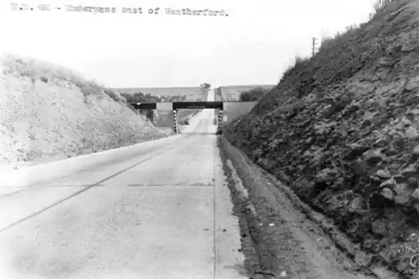
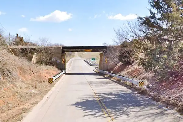
We will approach Weatherford from the east (coming from Hydro). After crossing the Little Deep Creek, 2 mi. east of town is a railroad tressle, built in 1931 across Route 66. Below is a "Then and Now" view.
Keep westbound. Ahead as you cross N Airport Rd., is "Lucille's Roadhouse" at 1301 N Airport Rd. It is a Route 66 themed restaurant with the looks of a 1950s diner (neon lights, chrome and glass brick), its shape resembles Historic Lucille's Place in neighboring Hydro; see its street view.
Here you will see the first of the "Weatherford - Route 66" brick and stone monuments that are located along Route 66 in town.
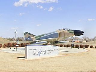
Just ahead is the Air and Space Museum (you can't miss it; it has a fighter jet at its entrance).
Stafford Air & Space Museum
3300 Logan Road, (Airport) Weatherford OK.
An aeronautical and space museum with a collection of spacecraft, from a World War V-2 rocket to a Titan II missile and a Saturn V engine.
It is named after Lt. General Thomas P. Stafford, born in Weatherford who was awarded the Congressional Space Medal of Honor. He flew four space flights, in the Gemini VI, Gemini IX, Apollo 10, and the Apollo-Soyuz Test Project Mission.
Full details at the museum's website.
Heartland Museum
All of the Route 66 motels on the eastern approach into Weatherford are gone. So you can stop by the "Heartland Museum" on your way to Main Street and visit a Valentine Diner where Elvis Presley ate!
On the southern side of I-40, 1.6 mi away (Map with directions) at 1600 S. Frontage Rd.
It has a collection of historic artifacts from the 1800s to the 1950s. with original buildings from Route 66: a diner, a one-room schoolhouse and the original 1900s Owl blacksmith shop.
More information at the museum's website.
Porter House "Valentine" Diner
Over the years there have been many Valentine diners in Weatherford.
These diners were invented by Arthur Valentine (1891-1954). He started to make these modular ready to use diners in 1947. His "Valentine Manufacturing Co." made over 2,000 of them in different sizes and models. They were prefabricated and came with all the fittings.
In the 1960s the company faced growing competition from fast food chains, lost business and folded in 1975.
The original location of this Aristocrat model Valentine Diner, back in 1949 when it opened, was 305 W Main next to Wright's Mobil, marked with a red arrow in the 1950s postcard below. It was owned and ran by Arvilla and Marvin Porter (hence its name). Soon they sold it.
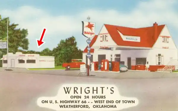
Then it was ran by Harry Wright who sold itm and it was moved to Texas. A second diner was bought, and qopened on the same spot ("Little Porter House") in the early 1960s.
The County bought the building in 1989, moved it away and used it for storage. Finally in 2002 it was donated to the museum. and restored.
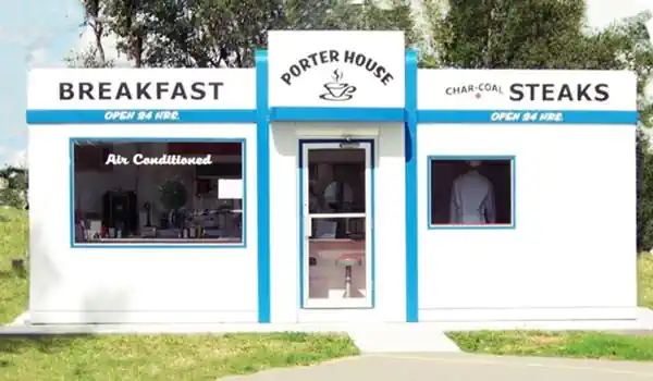
Elvis Presley and the Weatherford Valentine Diner
Elvis Presley stopped here, to eat, on his road trips to Las Vegas. The museum has the Diner's Guest Book with an entry dated April 22, 1960, signed by Elvis with a comment "Cool, Daddy".
Owl Blacksmith Shop
Listed in the National Register of Historic Places
Original location: 208 W. Rainey St. Now relocated to the Heartland Museum. The single story building was built around 1909 in wood with a gabled asphalt roof, it was operated by the Cotter family as a blacksmith and metal-working shop.
Route 66 was Weatherford's Main Street
Head west and drive along Main Street, which carried Route 66 from 1926 to 1970 (map with directions).
There were many gas stations and motels along it during Route 66's heyday, but they are mostly gone. Luckily, some have survived, we list them below.
Moore's Motel
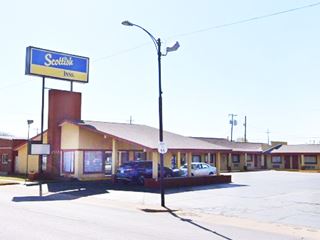
At 616 E Main, to your left, you will see the Scottish Inns, it used to be Moore's Motel. Below is an advert in the town's white pages ("Free Room TV"), and a street view of the motel.

1960s advertisement, Source
The Mark Motel
On the next block, to your right at 525 E Main, is the former "The Mark" motel, its 1960s advertisement tells us it "Electric heat, Room phones" and was a Best Western.
Nowadays, it still is a Best Western and has retained the original "Mark" part of the name.

The Mark Motel, 1960s ad, Source
Sinclair Station
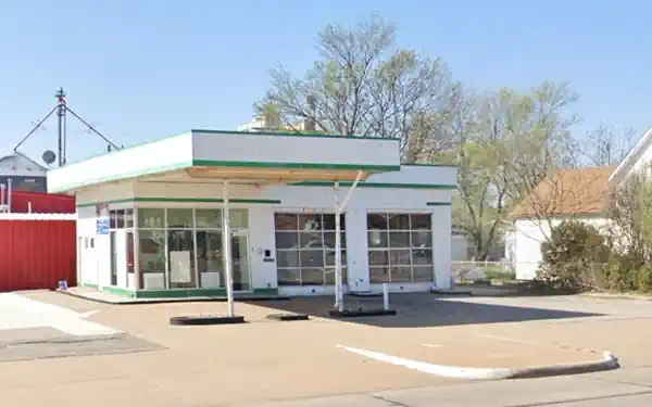
On the next corner (SW at 524 E Main and S Indiana St.), to your left is an oblong-box style former Sinclair station. It has a two-bay service area, flat canopy over a single pump island, and a corner office with large plate glass windows. This was the style used by Sinclair between 1950 and 1969.
Mike Smith Texaco
On the NW corner of Main and N Bradley St. (213 E Main) is a former Texaco known as "Smith Mike Texaco Service". It has three service bays and a corner office, no canopy or pump islands. The mansard roof has wood shingles and the columns have rectangular relief decorations.
Towne Centre monuments
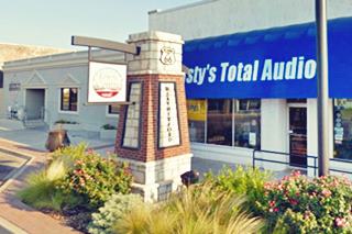
Ahead, two brick and stone columns, one on each side of the street mark the "Towne Centre", they bear the name "Weatherford" and an Oklahoma U.S. 66 shield. See picture above.
There are more markers around town (two are next to Blair's log cabin).
Take a right on the next corner, along Custer St. which is paved with bricks.
Brick Paving
Many streets still have their original red-brick paving, Custer is one of them.
Several blocks of Main Street (Route 66) were paved in brick until the mid-1950s when it was widened to a four-lane thoroughfare and the bricks were removed.
> Read more about Brick paved sections of Route 66.
Blair's Log Cabin
On the next corner, to your right. The SE corner of E. Franklin Ave. and Custer St., just across from the Post Office
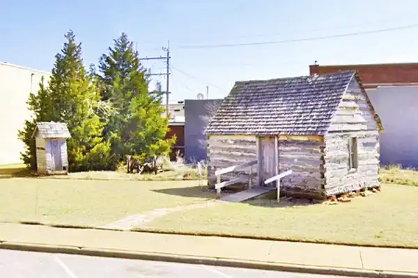
The log cabin is Weatherford's oldest building
The cabin was built with hand hewn logs by William H. Blair in 1892. He was a bachelor who took part of the Cheyenne-Arapaho land run.
In 1999, it was moved to its current location from its original site above the edge of a canyon west of town, and restored. Blair chose the spot because the ruins of an even older cabin were located there. He later married Francis Amanda Davison and moved to a home in the downtown district. He worked as a freighter carrying merchandise and lumber.
When you visit it, take note of the outhouse next to it! (on the left side of the image below).
Blair's 1892 log cabin, oldest building in Weatherford, Oklahoma
Head back to Main St. and continue west. To your right is a white stone building with the name "German National Bank" and "1909" on its frieze. Built in a Clñassical Revival style, it looks like a Roman or Greek temple with its two Doric columns (Street view). It dates back to 1909 when a large group of Germans settled in the area. During WWI it was named "Liberty Bank". Now it is a store.
The corner building next to the bank was the "Cain Hotel" with its Coffee Shop.
30-foot-tall Astronaut

"Land Yourself here"
Route 66 Centennial Landmark
To your right, on the NW corner of Broadway and Main (201 W Main St.)
Weatherford has added a new attraction. The town is known as the Space City of Oklahoma and houses the Stafford Air and Space Museum, so it this 30-foot astronaut is a great match.
It replaced the gazebo on Centennial Park, and is part of Oklahoma's grant for revamping Route 66 to celebrate the Route 66 Centennial (1926-2026).
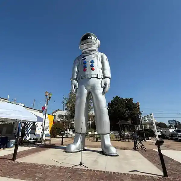
The statue is in the "McPhetridge Centennial Park". Before the astronaut and the gazebo, here stood a Shamrock Oil gas station and before that, Weatherford's first bank.
On the next corner, W Main and 8th St., once stood four service stations, one on each of the four corners. Three have survived until now.
You can see them in this 1959 aerial photograph (north is on the top).
Lyle's Conoco Station
On the NW corner, at 233 W Main, to your right, behind the "Town Centre" monument is Lyle's Conoco. The building now looks like a cottage, with a steep gabled roof. It is on the upper right corner of the aerial photograph. Conoco favored cottage style stations in the 1930-40 period, and this one has all the features: Steeply pitched cross-gabled roof with the front-facing gable off-center. Brick wall and a narrow vent in the gable end. The service bays were on the right side of the property, and a porch has been added, extending the gable forward.
Wright's Mobil
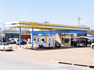
Across 8th St. on the NW corner. This service station underwent many changes over the course of the years. Currently it has a long flat canopy projecting from the office held up by four steel posts (pictured above), 3-service bays on the western side of the building, a red-brick front on the office and two parallel pump islands.
Back in the 1930s when it opened, it was a cottage style building. Magnolia had been absorbed by the Socony-Vacuum Co. in 1925 and sold gasoline under the Mobilgas brand. It also incorporated the Shield and Pegasus as its logo. Further up we posted a color postcard of Wright's gas station during in the 1950s, and below an earlier picture from the 1930s. As a Magnolia (Mobilgas) in the 1930s, managed by J.W Wright, it had a cottage style too, with a gabled roof over the canopy.

1930 ad Wright's Magnolia. Source

Wright's Mobil 1960s. Source
The 1960 image above shows a flat canopy (different to the current one) and the ad offers "The Wright Service".
Max' Skelly Service
Across Route 66, on the SW corner at 300 W Main was Max's Skelly. It's advertisement says "Washing & greasing Hood Tires - Batteries. 'Only Ice Dock in Weatherford' - Wheel Balancing".
Skelly operated between 1919 and 1977. This building has a flat roof and the canopy has rounded corners (a Skelly feature) and bands.
Site of Champlin Station
Facing it, on the SE corner (222 W Main), now vacant was Smalley Harvey's "Champlin" station. The Champlin Refining Company was an Oklahoma enterprise founded in 1916 and sold to Petrofina in 1984. See it in this 2016 street view before it was torn down.
On the next corner the 1926 alignment heads west, and the 1931 alignment takes a SW course. Both met further west. There are no landmarks along either of them. There is a former gas station at the fork (SW corner), "Wray & Wray" that sold Deep Rock, Morrison Oil Co. gasolline, Dayton tires and had a repair shop. This was 400 W Main. (Street view). Facing it, on the SE corner, is a small cottage style building, no pumps, no canopy, just a hipped roof with wood shingles and a single entrance with two large display windows. It is clearly an old building. Humble favored this style for gas stations in the 1930s. This is its St. view.
Heritage Park

US 66 towns mileage signpost. Source. Click for St. view
One block south along SW Main, and one block west on W Rainey Ave. There are some interesting sights in the park.
Wind Turbine Blade
As you drive towards Weatherford you will notice the wind turbines close to the highway, they are a large windfarm generating electricity. Inth park you can see a real turbine blade, 122 feet long (37 m). See its street View.
Custer County Veterans Memorial
On the corner, close to the turbine blade is the memorial in honor of the Custer County men and women who fought and died in the American Civil War, World War I, World War II, Korea and Vietnam.
Route 66 sign post
There are also some signs for Route 66 roadtrippers, a Route 66 shield, with a golden leaf wreath around it, a porch-pavilion with the US66 shield, and a post with
direction signs pointing to different Oklahoma cities (including Weatherford).
Also on W Rainey, but one block east of Route 66 is the historic Weatherford Armory.
Weatherford Armory
123 West Rainey, Weatherford, OK. (NW corner of W Wade and Choctaw Ave.)
Listed in the National Register of Historic Places
A Great Depression building (1935-1938), built in red brick. The first armory was established in town in 1924. The building to house it would have to wait until the Great Depression when the Works Projects Administration or WPA created work for the local unemployed men and built the armory in 1938. It served also as a community center. Its 45th Infantry Division saw action in World War II. See its St. View
This is the end of your Weatherford City tour along Route 66, continue your road trip westwards, into Clinton
Some sponsored content

Sponsored Content
>> Book your Hotel in Tulsa

Credits
Banner image: Hackberry General Store, Hackberry, Arizona by Perla Eichenblat
Jack DeVere Rittenhouse, (1946). A Guide Book to Highway 66.

