Route 66 in Lincoln IL
Index to this page
The Mill in Lincoln, Illinois
Information about Lincoln Illinois
Facts, Trivia & Useful Info
Elevation: 589 ft (180 m). Population 13,243 (2024).
Time zone: Central (CST): UTC minus 6 hours. Summer (DST) CDT (UTC-5).
Lincoln is a city that is the seat of Logan County, Illinois.
Lincoln its history
Central Illinois first inhabitants arrived shortly after the end of the last Ice Age about 11,000 years ago. In historic times both Illinois natives and Kickapoos lived in the area. The first to explore the region were French trappers in the mid 1600s. American and European settlers arrived here around 1800.
The distances to the large cities and the open grassland made farming complicated until the arrival of the railroad in the 1850s. Nevertheless, Russel Post, from Baltimore settled the area and in 1835 built a community (named Postville after him) by 1839 it had 100 residents and when Logan county was created that year, it became its seat.
At time when the Native Americans had been forcibly relocated west of the Mississippi.
Railsplitters
The nickname of the town of Lincoln is the Railsplitters (aka the Railers) because, Abe Lincoln split rails and used the wood to make fences.
The stagecoach that linked Chicago with ran through the town. But in 1848, the citizens of Logan County voted in a referendum to move the county seat to Mount Pulaski; this led to the decline of Postville. In 1865 the community merged into the new town of Lincoln.
The Chicago, Alton & St. Louis railroad passed through the area in the early 1850s and a town was platted by Latham, Hickox, and Gillette next to the depot.
It was officially named Lincoln on August 29, 1853, and Abraham Lincoln, who was a lawyer pleading cases at the local courthouse in the 1840s and 50s, christened the newborn town with Watermelon Juice.
Route 66 was aligned along an existing state highway in 1926. It was decertified in 1977.
The name: Lincoln
Named for Abraham Lincoln (1809 - 1865), lawyer, statesman, and 16th President of the US. Assasinated. He kept the country united through the Civil War, leading the way to the abolition of slavery. It is the only town in the United States that was named for and by Abraham Lincoln before he became president.

Lincoln: Hotels & Motels
Find your accommodation in town.
> > Book your hotel in Lincoln
More Lodging Nearby along Route 66
Below you will find a list of some of the towns along Route 66 east and west of this town; click on any of the links to find your accommodation in these towns (shown from east to west):
Along Route 66 in IL
- Hotels in Illinois
- Route 66 Starting point ▸ Chicago
- Lockport
- Willowbrook
- Bolingbrook
- Plainfield
- Romeoville
- Joliet
- Wilmington
- Dwight
- Pontiac
- Chenoa
- Normal
- Bloomington
- Atlanta
- Lincoln
- Springfield
- Raymond
- Litchfield
- Staunton
- Williamson
- Hamel
- Edwardsville
- Collinsville
- Troy
- Glen Carbon
- Pontoon Beach
- Granite City
- East St. Louis
West in Missouri
- Hotels in Missouri
- Florissant MO
- Bridgeton MO
- St. Louis MO
- Kirkwood MO
>> See the RV campground in Lincoln
Lincoln's Weather
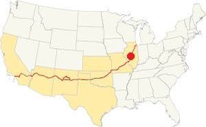
Location of of Lincoln, on U.S. 66 in Illinois
The climate in Lincoln is humid continental one with humid hot summers and cold winters.
Average temperatures during summer (Jul) are: High: 85°F (29.7°C) and Low 65°F (18.1°C); the winter (Jan) averages are: High: 34°F (1 °C) and Low: 18°F (-7.8 deg;C).
Annual rainfall is 36.7 inch ( 1008 mm) with a peak of 5.08 inch in July (129 mm) and a minimum of 1.93 in. (49 mm) in January. Expect snow from Nov. thru Mar. The average snowfall is 22 inch (55 cm).
Tornado risk
Logan County gets hit by about 7 tornados each year (Lincoln is located in Logan County).
Tornado Risk: learn more about Tornado Risk on US 66.
Map of Route 66 in Lincoln IL
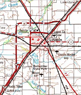
1958 USGS Map of Lincoln and US66
Heading southwards from Atlanta the highway keeps a straight course as shown with this blue line in our custom map.
On the northeastern side of Lincoln the highway forks into two alignments:
The 1926-40 US66
We marked it with a pale blue line in our interactive map.
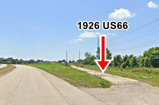
On the northeastern side of town, to the west of the modern highway you can see a segment of the original highway, now it is abandoned. This is a street view of it. And this is a Map showing where it is.
This original road continued parallel to the railroad and at the height of Harrison St. took a 45° turn south to then turn along what is now N. Kickapoo St. Most of it is now closed to traffic (except for the last section); see this Street View of the last part of the alignment (southern tip on Kickapoo).
Later (1930s?) the alignment was moved east along present Business 55 loop. From this point it heads south on the eastern side of the railroad, crosses the tracks to enter the commercial district and then heads westwards along 5th Street.
It heads south alont S Washington St. and Stringer Ave. crosses what later became Bypass 66 and ran by Lincoln's Cemetery, crossed Salt Creek and left the town.
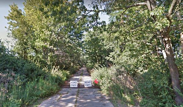
In the Salt Creek section, you can drive part of the original roadbed south of the cemetery and the creek until you reach a "Road Ends" sign (Map with directions).
1941-77 Alignment
The "Main US 66" mentioned by Rittenhouse in his 1946 Guidebook to US Hwy. 66, is the Bypass alignment that was built in 1941 and completed during WWII, to keep the heavy wartime traffic out of the downtown district (reducing congestion and accidents).
It remained operational until 1977 when the highway was decertified.
This "beltline" route ran along the western and northern edges of the city, and had an underpass to cross the railroad tracks.
The infamous "Blu Inn Curve" on this section, was named after a motel close to it was also known as "Killer Curve" even though it was a four-lane divided highway it was a right angle curve where speeding provoked many fatal accidents.
See this Map with directions showing the bypass alignment.
The Route 66 alignment in Lincoln
Visit our pages with old maps and plenty of information about US 66's alignments in this area.
- Springfield to Staunton IL (1926-30 US66) south from Springfield (next)
- Springfield to Hamel (after 1930) south from Springfield (next)
- Pontiac to Springfield (Lincoln's)
- Chicago to Pontiac (previous)

Lincoln and its Route 66 Attractions
Things to see in town
Lincoln's US 66 in 1946
Jack Rittenhouse wrote about the town in his classic Guide Book to Highway 66 published in 1946; he mentions the Hoelscher Bros. and Sheer garages, the Western, Commercial, Lincoln hotels and Elm Grove Court.
Regarding the route's alignment he mentions the bypass alignment as "Main US":
Main US 66 straight ahead city route forks left. At a junction with Illinois Road 10, just north of Lincoln are gas stations and cafes... at the south edge or Lincoln, City Route 66 comes in from the left to rejoin the Main Route. Jack Rittenhouse (1946)
He also writes about Logan county Fair Grounds, and that the city was named for Abraham Lincoln.
Drive through Lincoln on Route 66
Our city tour starts at the southern side of town Stringer Ave. and Historic Route 66 and ends on the north side of town; it is a 6.9 mile drive. See this Map with Directions.
City Tour in Lincoln
From South to North, and South again
Head north along Stringer Ave. which was the 1926 alignment of Route 66 (also State Hwy 4), later it became City 66 and even later Business Route 66.
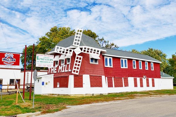
After 0.4 mile, at the railroad grade crossing, to your right, on the NE corner of Stringer Ave. and First St. is the "Mill".
The Mill Museum on 66
Route 66 roadside attraction
738 S. Washington (Route 66), It first opened in 1929, just 3 years after Route 66 was created. It closed in 1996 and fell into disrepair. Funds were raised to restore its roof, windows and floor. It took 11 years of hard work and fundraising, but the building finally reopened as a museum in 2017.
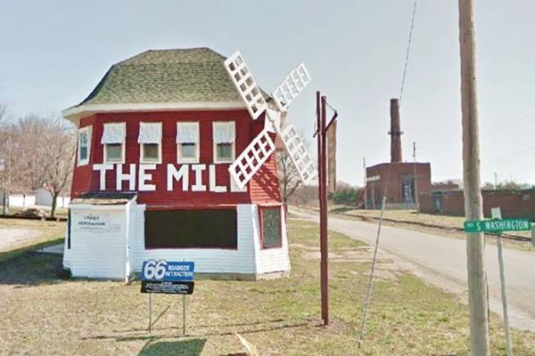
It was known as "The Blue Mill" (now it is painted red, but at that time it was blue) and was ran by Paul Coddington. In 1936 Raymond Hickman and his wife Fern took it over. The photo below was taken in 1937. It was later known later as "The Mill" with its Dutch-styled building that even had a revolving windmill.
Albert Huffman bought it in 1945 and added a dance hall in the back, and painted it red. By the 1980s it had become the "Home of the Schnitzel" (a breaded veal or pork).
The pictures below show it in 1937 and c.1940, old black and white images (Credits.)

1937 Photograph of The Mill

ca. 1940 photo of The Mill
Continue north along Washington and when you reach 5th St., turn right. To your right is a Classic Gas Station:
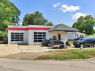
Logan Service Station
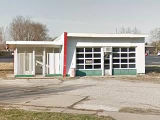
5th St. and Washington. This service station is still standing, and has a 2-door garage and a gabled canopy. It is pictured below. It opened as an Illico Service Station in 1925 and was owned by Herb Beach. Later Bob Sanders ran it in the 1930s. More recently it was Dick Logan AutoCare Center (2000s). Click images for Street View:
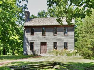
Postville Courthouse
State Historic Site
Head east along Fifth Street. Three blocks ahead, to your left, set in the middle of a park, is the Historic Courthouse at 914 5th St.
The building pictured above is a replica (completed in 1956) of the original building that was erected in 1840 in Postville, the seat of Logan County at that time. Between then and 1848, Abraham Lincoln visited this courthouse site twice a year during his circuit law practice. Later the county seat moved to Mt. Pulaski and the courthouse was relocated there.
In 1929 Henry Ford bought the building, dismantled it and set it up again at his Greenfield Village in Dearborn, Michigan.
Dial’s Texaco
Continue along Fifth St. eight blocks further east, to your left at 106 5th St (Union and 5th NW corner) is a former Texaco.
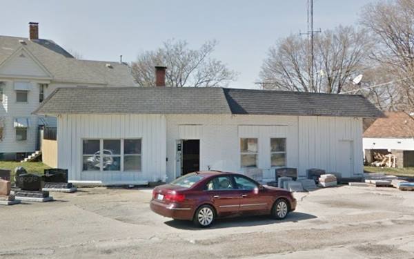

1970 photo Dial Texaco. Source
It now houses a monument maker business (for gravesides), it used to be the Dial and Jones’Texaco gas station (later just Dial’s).
The building is still standing and the outline of the concrete pump islands can be seen in the tarmac.
Red Brick Road
At Logan St. turn left and head north. To your left South Logan St. is paved with red bricks see street view.
To the right is a Tudor style building with leaded glass windows, however we haven't yet found out waht it was during Route 66's golden days.
Turn right into N. Logan St. and head north, take a right along Keokuk St. Just ahead, after crossing the railroad tracks, to your left is another Old gas station.
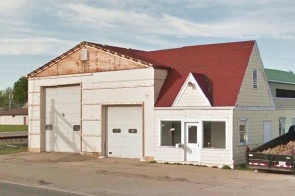
Cottage Style gas station
620 Keokuk St. It has a two door garage (one was made smaller, but the old outline is visible) and is of the cottages-style, popular in the late 1920s to early 1930s when gas stations were meant to blend in with their urban surroundings. The shape of the former pump island is also visible on the concrete paving.
Sidetrip into Lincoln's Business District
Historic District
Turn right and head down N. Kickapoo St. into Lincoln's historic Business District.
Route 66 Marker in Lincoln
At the Intersection with Pekin St., on the SW corner is one of Route 66's "Experience Hubs", a sleek marker (Street View). It was erected by Illinois Route 66 Scenic Byway.
At the next intersection, at Broadway, turn right, and to your right, two blocks away is the old Lincoln Depot and the Lincoln Watermelon Monument.
Lincoln Watermelon Slice Monument
Kitsch and Americana
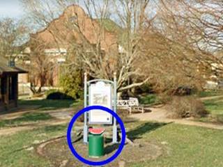
480 Broadway St. The Watermelon Slice Monument is located next to a sign at the Lincoln Depot, on the north side of Broadway, between the tracks and N. Chicago St.
The town was named after Lincoln and it was he who in 1853 christened it with melon juice. He said "Gentlemen, I am requested by the proprietors of the town site to christen it. I have selected the juice of a melon for that purpose, pouring it on the ground."
The monument was erected in 1964 thanks to th local Kiwanis, Lions and Rotary clubs, it is tiny -see picture below in the blue circle.
It is a watermelon slice sitting atop a concrete base. Behind it is a sign-marker with a descriptive text.
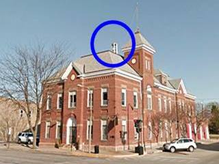
Retrace your steps but head straight along Broadway. On the block after the Courthouse, to your right is very strange sight: a phone booth atop a building. Click images for Street View
Phone Booth on Lincoln City Hall
Weird Things
700 Broadway Street. The City Hall is a red brick building built in 1895. You can see a telephone booth on its roof which was used by weather spotters to report the storms that they sighted. It is part of the Historic Downtown District. Pictured above, blue circle. It was slated for removal in 2009 as new technologies made it obsolete, but it was retained for its historic value.
If you head straight east for ten blocks you will see another vintage gas station.
Sinclair station
1717 Broadway St, Lincoln. This is a former Sinclair service station from the 1940s, although it was not on Route 66 it dates back to those days. Now it has been restored for another purpose. It is pictured below.
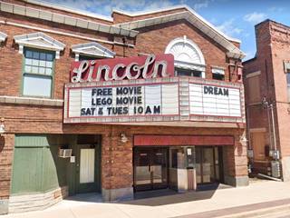
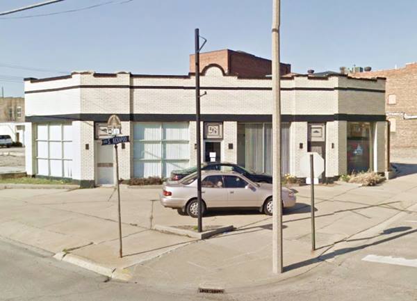
Return to S Kickapoo and turn left. Two blocks ahead, to your right, is the Lincoln Theater, pictured above, and just past it, on the NW corner of Clinton St. is yet anoter Antique Service Station.
Vintage Service Station
On the corner of Kickapoo and Clinton is another iconic gas station and just north of it the Lincoln Theater, a red-brick classic theater:
This ends the Downtown Tour. Drive north to return to Keokuk St. and continue your journey.
1926 Alignment
Just past Yosemite Ave. to your left is a street that meets Route 66 at a 45° angle: it is the 1926 alignment of Route 66. This is its Street View of it.
Head north until Kickapoo's junction with Historic Route 66.
This marks the end of your drive along the 1926-41 main alignment, that later became the "City 66" or Business 66.
Return south along "Bypass 66"
Return to your starting point but now using the Bypass 66 built in 1941. It is a 5.5 mile trip and this is its Map with Directions. So, turn left along the Old Route 66 and head south.
Original 1926 Roadbed
Turn left into Historic US 66, and just ahead, to your right, close to the tracks, you will see the old 1926 roadbed. Stay on the main highway. Ahead, Bypass Route 66 curves right and passes under the tracks. This alignment curves around the north and western sides of the city.
Roughly half-way across it, to your left is the Former Buckles Motel.
Buckles Motel
230 W Feldman Dr and Oglesby Ave. This "L" shaped motel was owned and managed by Paul and Ruth Buckles. The 1959 postcard shown below described it as follows: "12 Modern Units - Air Conditioned - Ceramic Tile Baths... T.V. in rooms..."
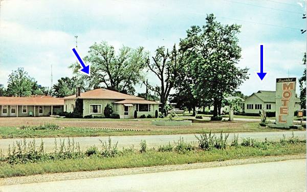
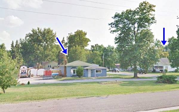
The sign has gone, but the old motel's office remains unchanged and also the building to the right, across the street (we have marked both with blue arrows). The main units to the south are gone. The eastern flank has survived.
Blue Inn's Killer Curve
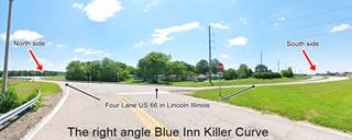
Blue Inn Killer Curve. Click image to enlarge. St. view
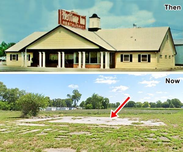
Ahead the road curves sharply to the south. This was a deadly curve; the Blu Inn once stood just south of here, so it was known as the "Blue Inn Curve" or the "Killer Curve". It was one of many dead mans' curves of Route 66. The inn became the "Heritage Inn" and was torn down in the early 2000s; you can see it in this 1957 aerial photo with the hip-roof. Below is a Then and Now set of pictures:
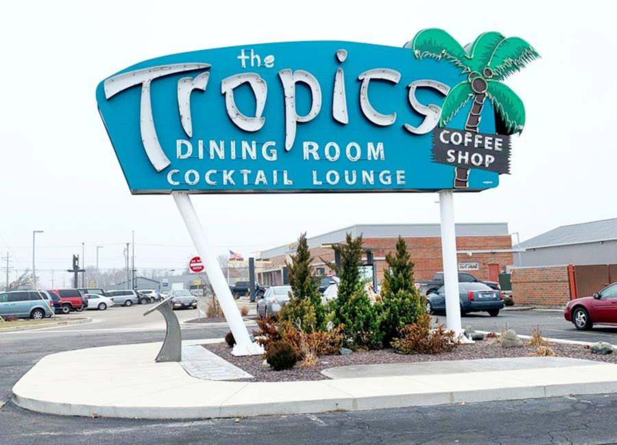
The Tropics Café Neon Sign
Ahead, on the NW corner at the junction of US 66 with IL-10 & IL-121 (Woodland Rd.) at "Four Corners" once stood the Tropics Dining Room with its emblematic neon sign.
The site was to your right but the restaurant is gone, as it was demolished. The sign was restored and relocated close to its original placement (Street View).
The original Tropics restaurant building opened in 1950 by Vince Schwenoha. Later it was operated by Lew and Bev Johnson. The opening of the freeway hurt business and it opened and closed several times over the following decades.
It was inducted into the Route 66 Association of Illinois Hall of Fame in 2016 and torn down shortly after (April 2017) to be replaced by a new McDonald's.
The iconic Tropics Neon Sign
The original Tropics Dining room sign was taken down in 2014 and put in storage by the City after it had been abandoned for about 20 years. It had hundreds of pounds of bird nesting and waste in it which were removed during restoration funded with a National Park Service grant.
Restored Tropics Neon Sign
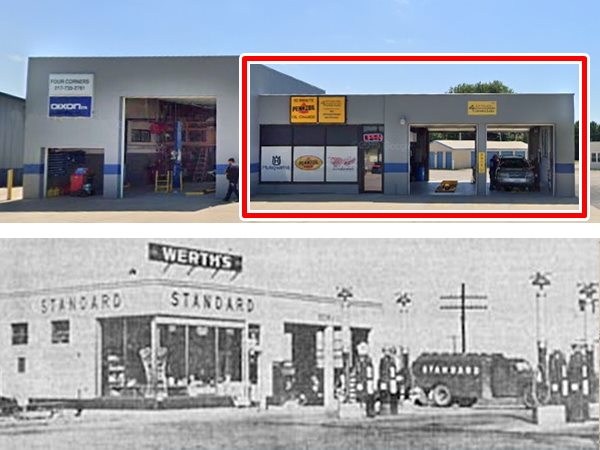
Werth Standard Gas Station
Ahead, across Woodland Rd. is the old Werth Standard Oil at 1101 Woodlawn Rd. Wilfred "Squeak" Werth opened it in 1934, in its day it was a rough stone building. Later he reformed it adding two garage bays and a glass window office. Werth boasted that it had the most modern pumps in Illinois (displaying the value in dollars and cents).
As you can see in the image below, the right side of the current building is identical to the original icebox Texaco from the 1930s. Werth's Realtor offices are located behind the former gas station.
In 1956 he opened a motel next door, the Redwood.
Werth's Texaco station, then and now. Lincoln, Illinois
Redwood Motel
At 725 Hickox Rd. Just a block or so south of the Tropics is the Redwood Motel, opened in 1956 by Wilfred "Squeak" Werth and his wife, Dorothy.
It had "Only 15 cozy very clean units." They sold the motel to Ruth Buckles (of the Buckles motel) in 1963. The motel's sign was replaced in 2000 and Sherman West and his wife, Joan took over in 2003.
Redwood Motel in the 1960s. Lincoln, Illinois
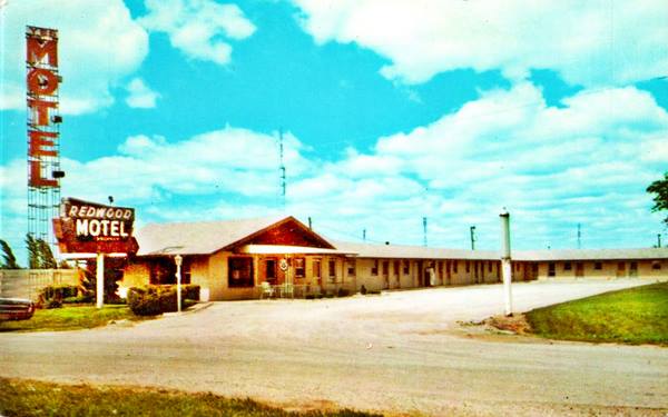
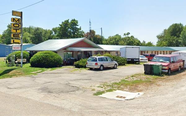
Lincoln Motel
Turn eastwards along Woodland Rd., just 300 yards east of Route 66, to your left is a Classic Motel at 974 Woodland Rd. It is a single-floor, rectangular shaped brick building with a gabled roof. It hasn't changed much since its heyday in the early 1950s, but its neon sign is gone. Its postcard tells us it had 15 units and "Large Ceramic Showers - Beauty Rest Mattressess... Pets accepted. Mrs. Joe Kodatt, Residential Mgr. Owners, H. F. Austman & J. H. McNally:"
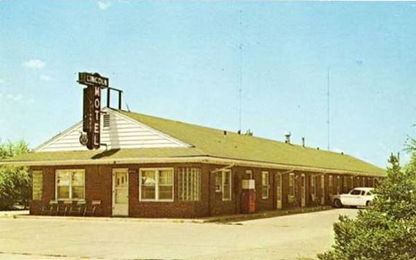
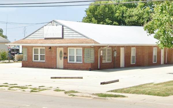
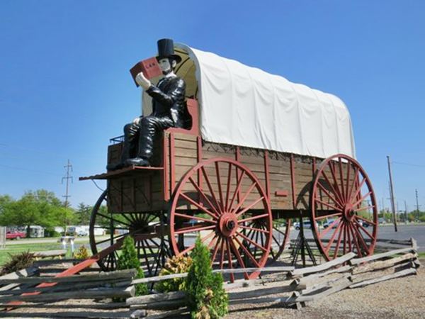
World’s Largest Covered Wagon
Americana - Kitsch and Guinness World Record and Route 66 Roadside Attraction
Retrace your steps back to Bypass 66 and turn left, going south. Ahead is an example of Americana and Kitsch, to your left, on the west side of the road at the Best Western Lincoln Inn at 1750 5th St, Lincoln.
Hand built in 2001 by David Bentley in oak and steel it is the current holder of the Guinness World Record for being the largest covered wagon.
It is 40 x 12 x 25 feet (12.2 x 3.65 x 7.6 metres) and was built to commemorate the 75th anniversary of Route 66. Guinness site, Read more.
World’s Largest Covered Wagon in Lincoln, Illinois
Route 66 in the Cemetery: 1926 alignment
Now is the final part of your journey. Visit the 1926 section of the highway at the Cemetery. Turn ight at Kenwood Dr. and left along Cobblestone Dr. you are at the Union Station Cemetery (map with directions).
Ahead the road is closed to vehicles, but you can walk it. It is a brick paved in its first section. It is a short 0.35 mile walk to Salt Creek and site of the old bridge, which has been dismantled and only the concrete pillars remain.
This is a Street view of its first part.
1926 alignment South of town
The original alignment laid down in 1926 in the Salt Creek section can still be driven south of the cemetery and the creek until you reach a "Road Ends" sign (Map with directions).
1926 roadbed of Route 66 south of Salt Creek Lincoln, Illinois
Continue your Route 66 Road Trip
This marks the end of this leg of your road trip in Lincoln, head south to continue your journey and visit the next town: Broadwell.

Sponsored Content
>> Book your Hotel in Chicago

Credits
Banner image: Hackberry General Store, Hackberry, Arizona by Perla Eichenblat
Jack DeVere Rittenhouse, (1946). A Guide Book to Highway 66.


