Route 66 in Edgewood NM
Index to this page
About Edgewood, New Mexico
Facts, Trivia and useful information
Elevation: 6,700 ft (2.000 m). Population: 6,095 (2025).
Time zone: Mountain (MST): UTC minus 7 hours. Summer (DST) MDT (UTC-6).
Edgewood is a town in Santa Fe County, which ovelaps into neighboring Bernalillo and Torrance counties, New Mexico. It is located on the eastern slope of the Sandia Range, along to Route 66's 1937 alignment. Its motto is: "Where the Mountains Meet the Plains"
History
This area has been inhabited for more than 10,000 years (the nearby archaeological sites at Sandia Cave and Clovis has some of America's oldest stone tools).
The trail from the high desert that headed up into the Tijeras Canyon from the east, was very ancient and had been used by the Native Americans who peopled the area for thousands of years. Later, after the mid 1500s, the Spanish explorers used the natural divide in the Sandia Range to link the Rio Grande valley with Lake Estancia to the west.
After the Mexican - American War (1846-48), the U.S. incorporated the area as the Territory of New Mexico and settlers began arriving from the East. The old wagon trail from Santa Rosa passed by here.
Although many homesteaders had set up their ranches in the area, the town was founded in the early 1930s in the southern part of Santa Fe county. Many of the "founding families" still live in the area.
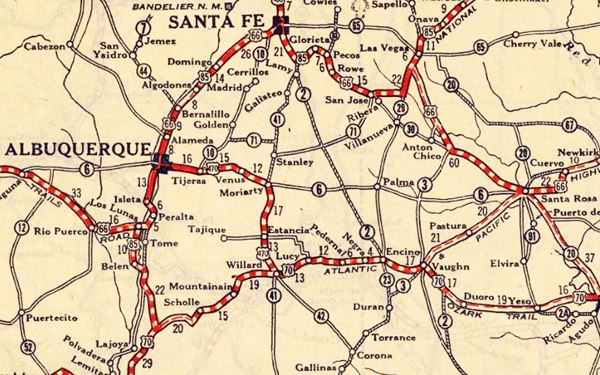
Its first name was Venus and it appears under this name in a Rand McNally map published in 1927 (see above). At that time US Highway 470 linked it with Albuquerque and Moriarty, unpaved east of Tijeras. Ten years later Route 66 would be aligned along it.
It then took the name of "Mountain View" which is appropriate considering its location, but it was short-lived. It was renamed as "New Barton", after the nearby town of Barton. But finally it was named Edgewood, and the name stuck.
Edgewood, the name
After the Post Office authorities rejected the name "Venus", the locals chose another name. Edgewood is named for its location, on the "edge" of the "woods", as it is located on the slopes of the wooded foothills of Sandia Range, where they meet the grasslands of the high desert.
The timing was perfect because in 1937 Route 66 was opened from Santa Rosa to Moriarty and onwards through Edgewood all the way to Albuquerque, bypassing Santa Fe and funnelling the traffic through the new community.
Soon some garages, diners and service stations appeared to cater to the travellers. The town, spread out along the highway, prospered. And by 1946, Jack DeVere Rittenhouse described it as having cafes, gasoline but no lodging. He also mentioned that it was a shipping point for pinto beans.
It incorporated in 1999, becoming the Town of Edgewood and its boundaries overlap into Bernalillo and Torrance counties. Although it is part of Santa Fe county, it is closer to Albuquerque (20 miles vs. 51 mi.) and is home to many commuters who work in Albuquerque. Its population duplicated has increased over the past 20 years.

Where to Stay: Hotels in Edgewood
Neighboring Moriarty and Albuquerque have plenty of lodging options for those travelling along Route 66, you can book a hotel or motel in town:
>> Book your Hotel in Moriarty or Albuquerque
More Lodging Near Edgewood along Route 66
Below you will find a list of some of the towns along Route 66 in New Mexico. Click on any of the links to find your hotel, motel or accommodation in these towns (listed from east to west):
On Route 66's Main alignment
The Santa Fe Route 66 segment
Eastwards
Westwards
>> There are RV campgrounds in Edgewood and also nearby.
The weather in Edgewood
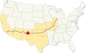
Location of Edgewood on Route 66
Edgewood is located on the edge of the high desert, in the foothills of the Sangre de Cristo - Sandia Mountains. Although dry, the area is cooler than the lower regions to the east. On average 13 in. of rain (330 mm) fall per year during an average of 58 days with precipitation. The highest takes place during summer from July to October. Snow averages around 25 inches (63.5 cm) and falls between October and April.
Summer is hot but during the temperature drops during the night (influenced by the higher altitude). Winters are quite cold.
The average high temperature in Summer (Jul.) is 87°F (30.5°C), while the average low is 54.5°F (12.5°C).
The winter average high temperature (Jan) is 44°F (6.7°C) and the average low is 15°F (-9.4°C).
There are around 274 sunny days per year.
Tornado risk
Edgewood is in an area with virtually no tornado risk: Santa Fe County has no Tornado watches.
Tornado Risk: read more about Tornado Risk along Route66.
Map U.S. 66 in Edgewood New Mexico

1937 roadmap near Edgewood Source
Click to enlarge
The historic 1926 alignment of Route 66 following the National Old Trails ran further north following an ample curve which headed from Santa Rosa towards Las Vegas, NM and Santa Fe. From there it headed southwards, to Albuquerque.
Edgewood was located on the short lived US 470, that later became US 366 named so because it was a spur of US66.
The "Santa Fe cut-off" shortened the road with a direct alignment from Santa Rosa to Albuquerque through Moriarty, Edgewood and Tijeras. This section was completed in 1937 along a new roadway to Moriarty and then along US 366, that became US66 into Albuquerque.
The thumbnail map -click on it to enlarge it- shows Moriarty on the lower right side, with no Route 66 running right towards Santa Rosa. It shows US366, Edgewood, and a winding highway through Barton, towards Sedillo, Tijeras and Carnuel. The 1937 alignment of Route 66 has now become NM-333, which runs on the south side of I-40.
Route 66 Alignment near Edgewood
With maps and full information of the old roadway.
- Santa Rosa to Albuquerque (Edgewood's)
- Tucumcari to Santa Rosa (previous)
Edgewood: its Attractions
Landmarks, Route 66 sights in Edgewood
Historic Context: 1946
In his 1946 Guidebook to US Highway 66, Jack Rittenhouse mentions Edgewood and the area around it along US66
Edgewood... cafes; gas; no tourist facilities... About a dozen buildings here. Rittenhouse (1946)
Rittenhouse tells us that it had a population of 132, it was set in an area with a few cattle ranches but that its main business was the "Shipment of pinto beans."
It was followed by Barton, "Three miles farther... which consists of a gas station, grocery and a few cabins."
West of Barton the highway kept on climbing reaching, 3 miles ahead, the highest point east of Albuqurque "about 7,000 feet." Route 66 which had been a straight road up to this point, winds its way down through Tijeras Canyon all the way to Albuquerque.
There is one final stop, 1 mile west of the highest point, and 7 miles west of Edgewood, with "Gas station, with cafe and grocery." Below we will describe these points along Rittenhouse's 1946 itinerary.
Edgewood, Where the forest meets the plains.
Driving west from Moriarty Route 66 runs witha a straight course, towards the mountains that that can be seen in the distance. Six miles west of Moriarty, to your right (map with directions) is a former Trading Post built around 1945 that had a gas stsation, post office, curio shop and cafe.
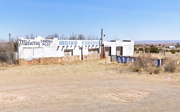
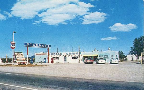
The Retro 66 non-profit organization conducted a community clearn up and repainted the old building's exterior. It will be gradually restored.
Drive west for another 1.3 miles and to your right is the Edgewood RV Park.
The Valentine Diner at Edgewood
Red Arrow Campground RV Park
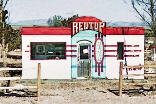
Here was the first location of the Red Top Valentine Diner, below is a picture of it in 2012 while it stood here:
Red Top Valentine Diner on US 66 in 2012 Edgewood
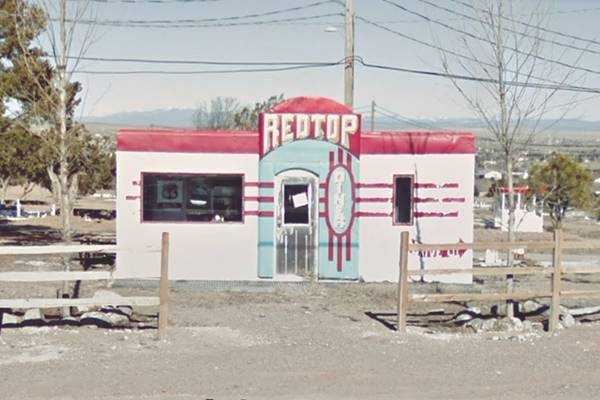
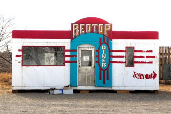
The park's late owner, Jerry Ueckert (1951-2022) found the Aristocrat model Valentine diner in Magdalena and spent a lot of time to renovate and restore it. He named it "The Red Top", and at first parked it in his campground. But later moved it to the Wildlife West Nature Park to keep it safe after it was vandalized.
Jerry was the "Champion of Route 66", and dedicated countless hours to promote the mother road; he co-founded the Route 66 Chamber of Commerce, and later was the managing editor of Route 66 magazine. He was also part of Retro 66. Red Arriow had belonged to his parents Fern and Tex Ueckert who also owned a grocery store in Edgewood. 1)
Wildlife West Nature Park
You can visit the diner; it is located in the Wildlife West Park, 1.6 miles away (map with directions), northwest of Edgewood, at 87 North Frontage Road, Edgewood, NM. (I-40 Exit 187)
Their website: www.wildlifewest.org.
This non-profit organization is a wildlife preserve that focuses on plants and animals native to the ecosystems of the Southwestern U.S. and of course, New Mexico.
You can see bobcats, whitetail deer, puma, wolves and coyotes among other animals in a 122 acre park.
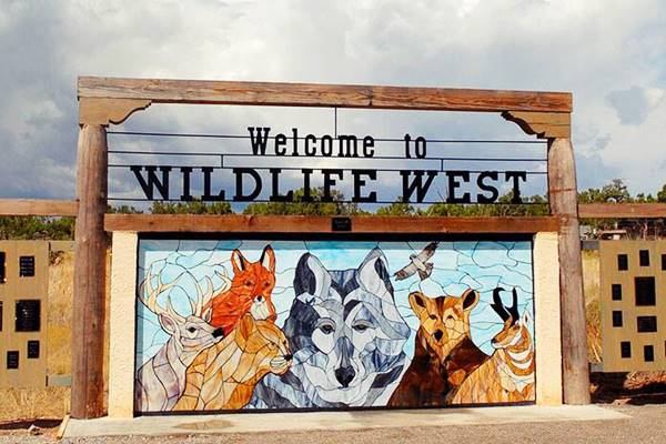
Valentine in the park
The Valentine is beside the park's buildings (this map shows where).
The diner was one of at least 2,000 diners built by the Valentine Manufacturing Company of Wichita, Kansas.
Arthur Valentine (1891 - 1954) invented them and began producing them in 1947. They were movable diners that came in different sizes and models. The Aristocrat had eight seats. The company gradually lost business in the 1960s and folded in 1975, the fast food chains and suburbia had displaced the small diners.
See other Valentine's on Route 66 in: Winslow AZ and Albuquerque NM or the one in Twin Arrows, Arizona.
Red Top Valentine Diner at Wildlife Park in 2022 Edgewood
Edgewood's "downtown" US66 & NM 366
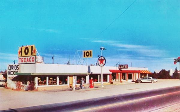
Back to your Road Trip. Just ahead, after the campground is "downtown" Edgewood. As you can see in this Aerial photo from 1952 the town was located to the east of the crossroads of US66 and NM 344. Nothing remains of the old town's cafes and gas station mentioned by Rittenhouse except the 101 Cafe and Texaco.
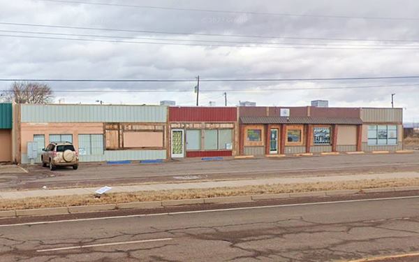
101 Texaco and Cafe
To your left, as you approach the crossroads, are some buildings which made up the 101 Cafe (on the eastern side), with angled brick pillars between the windows, and the gas station that had a trading post that sold moccasins and curios on its western side. The postcard also shows a motel sign (curved red arrow and letters "Mot..") on the right side of the image. Below is a Then and Now set of pcictures.

Snake Pit in 1975, Edgewood US66. Credits
Also at Edgewood was an Indian Wishing Well. You can see it in this picture by William Lucas, taken in 1975 is captioned: "Snake Pit at Taylor's Store in Edgewood N.M., April 1975". The sign reads "Indian Wishing Well - Drop um coin make up wish snake drink wish come true."
Ghost Town of Barton
Drive west, after 3.5 mi (map with directions), to your left Sedillo Rd. forks towards the west. This is the site of the long gone village of Barton. This community preceded Edgewood, but now is just a fading memory.
Barton
Elevation 6,820 ft (2.080 m). Pop. n⁄a.
Located in western Bernalillo County, the now "Ghost town" of Barton is part of the town of Edgewood.
A post office opened here in 1908 and adopted the name of an early settler. The post office moved to Edgewood in 1936. It was described by the 1946 Route 66 guide of Jack DeVere Rittenhouse as having gas, a grocery store and some cabins. Now it has some scattered homes and sheds along the road.
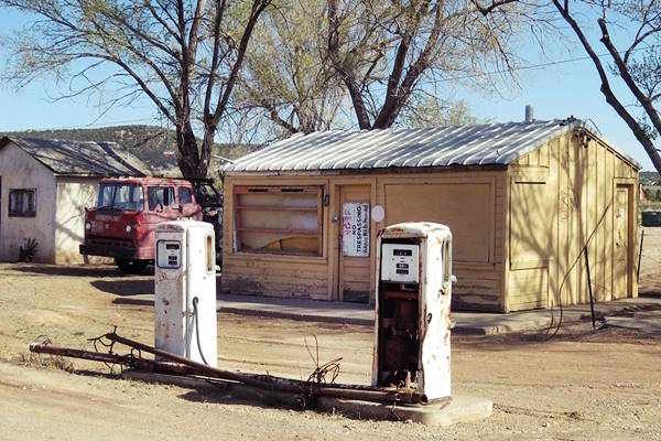
The interesting sight is the former Conoco Service Station, of which some old gas pumps still remain; see the St. view of the old gas station.
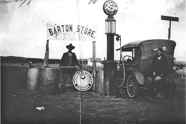
The caption of the image tells us the picture was taken in 1920, showing Alva and Abraham Reeves at Barton Store. We see that it sold Magnolia gasoline.
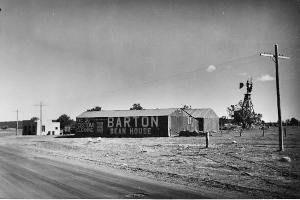
The image above is captioned "Town of Barton," and was taken in 1937, the same year that Route 66 was realigned through the village. It looks towards the southeast from Route66.
This aerial photo from 1952 shows buildings on both sides of Route 66 at the junction of Sedillo Rd. in barton. The same place nowadays only has what remains of the windmill: its tower; the rotor and tail have gone. The buildings were torn down too.
Lester's Conoco Station
Drive west for another 0.9 miles and, on the NW corner of the junction of Route 66 with NM 217 is a former Conco station. To your right.
Lester's Conoco dates back to the late 1950s (it does not appear in the 1952 aerial photos). It has two 1950s Tokheim gas pumps and a small office beside the pump island. There is another island with pumps to the left, with a flagpole, and behind the buildings, visible from the highway is a small wall with license plates on it (2022 St. view)
Sedillo
Continue driving west, and 1.2 miles ahead, at Brad Ct. is where the original 1937-49 Route 66 alignment went right, into Sedillo (it is cut by I-40 yellow line in our custom map). You can drive this alignment from Exit 181 of I-40. It curves to the north in a loop through Sedillo (current Hwy. 306), and then back to the south, into Tijeras (map), narrow, and winding, it was replaced by a straighter roadbed in 1949, which now is the South Frontage Rd. of I-40.
Comer's Coffee Shop
Just half a mile ahead, to your left is the Route 66 Sedillo Hill Travel Center (map showing the spot) site of Brad Comer's Coffee Shop at Sedillo Hill. See it in this 1951 aerial photo and in the postcard below that places it "24 miles east of Albuquerque."
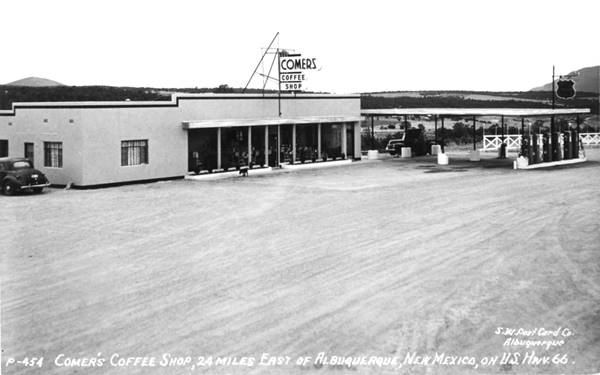
It is mentioned in 1955 in the Albuquerque Journal as being "Brad Comer's Coffe Shop at Sedillo Hill"; a 1958 article from the same paper states that Comer's Cafe was owned by Werner Eisenhut.
It had a Phillips 66 gas station. Bypassed by the freeway, the building has survived as a Travel Center.
Highest Point on US66 east of Albuquerque 1945-85 alignment
The road rises as you head west out of Barton towards Sedillo and here it reaches 7,057 feet (2.150 m) at the Exit by Comer's. As Rittenhouse mentioned in 1946: "US 66 continues to climb, until you reach the highest elevation east of Albuquerque at 280 mi. (24 mi), being up about 7,000 feet." The spot is 24 mi. east of Albuquerque.
Highest Spots Along Route 66
There are several passes along Route 66 where it crosses mountain ranges, the highest spots are the following:
- 7,550 feet (2,301 m). Glorieta Pass NM, Sangre de Cristo Mountains. Highest point from 1926 to 1937. On the Santa Fe Loop.
- 7,405 feet (2,257 m). Bellemont to Parks, Arizona, crossing the San Francisco Mountains, 1931-41 alignment.
- 7,245 feet (2,208 m). Continental Divide, New Mexico, crossing the Rocky Mountains. 1927-85 alignment.
- 7,102 feet (2,166 m). Sedillo, NM on the 1937-45 alignment, replaced when it was realigned, by a spot at 7.057 feet (2,150 m). Comer's Cafe close to Sedillo on the 1945-85 alignment. Crossing the Sandia Mountains.
- 3,595 ft (1,096 m). Sitgreaves Pass near Oatman, California, crossing the Black Mountains. 1926-53 alignment.
Continue your Road Trip
Continue your Route 66 road trip by heading west into the next town, Tijeras NM.
Sponsored Content

>> Book your Hotel in Albuquerque

Credits
Banner image: Hackberry General Store, Hackberry, Arizona by Perla Eichenblat
Valentine Diners
Jack DeVere Rittenhouse, (1946). A Guide Book to Highway 66.


