Route 66 in Santo Domingo (Kewa) NM
Index to this page
About Santo Domingo Pueblo (Kewa), New Mexico
Facts, Trivia and useful information
Elevation: 5,200 ft (1.586 m). Population: 2,400 (2025).
Time zone: Mountain (MST): UTC minus 7 hours. Summer (DST) MDT (UTC-6).
Santo Domingo or "Kewa Pueblo" as it is now known, is a census-designated-place and village in Sandoval County. It was located on the alignment of Route 66 from 1926 to 1932.
History
The Rio Grande Valley in New Mexico has been inhabited for over 10,000 years (the site at Sandia Cave is clear proof of this). The pueblo's Native Americans belong to a group who speak an eastern dialect of the Keresan languages. The Keresans lived in the region around Chaco Canyon area in New Mexico and Mesa Verde, Colorado until 1200 A.D., but the climatic change caused social upheaval and they migrated 150 miles to the historic pueblos near the Rio Grande and other rivers that flowed south from the Rocky Mountains. They used this water to irrigate their crops of squash and corn.
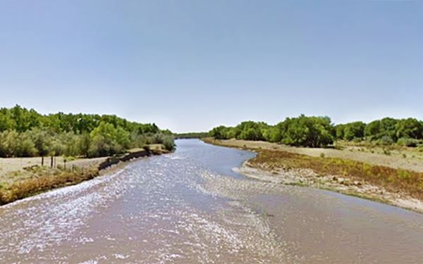
The Spanish explored New Mexico in the mid 1500s when Francisco Vásquez de Coronado named the native people "Pueblo", after the Spanish word for "village".
During his expedition on 1598 Juan de Oñate reported several Pueblo villages along the native trade route that bordered the Rio Grande River and one of them was the Pueblo of Santo Domingo.
The original site of the pueblo which in those days was named "Gipuy" (Alphonse Bandelier, a Swiss-born American archaeologist recorded the name "Quigui" in the 1880s) was located about two miles east of the Domingo railway station on the Galisteo River.
Oñate established a monastery here, named Nuestra Señora de la Asunción. A flood in 1605 destroyed the villages so the natives relocated it to the current site on the Rio Grande and renamed the pueblo "Khe-wa" (now Kewa Pueblo).
Origin of the name Santo Domingo
The Spaniards used the names of Catholic saints, the Virign Mary to name their towns in America. In this case they used the name of Santo Domingo (Saint Dominic, 1170 - 1221), a Spanish saint and founder of the Dominican Order.
In 2009, the pueblo officially changed its name to Kewa Pueblo.
The Spanish "Camino Real" (or Royal Highway) linked it to Santa Fe in the north and Mexico City in the south via Santo Domingo and Albuquerque.
The Spaniards set up their headquarters in Santo Domingo for the province of Queres, which comprised pueblo San Felipe and Pueblo Cochiti. The Franciscans established a mission in Santo Domingo in 1607 and their supervisor was located here in 1610.
The opressive practices of the Spanish, who imposed forced labor on the natives, and the persecution of their religion led to an uprising, the Pueblo Revolt of 1680, which led to the expulsion of the Spanish from New Mexico and the destruction of their missions and villages.
The Spaniards returned in force in 1692, subdued the rebels. The natives from Santo Domingo had moved out and joined those at Jémez Pueblo to resist the invaders but they were defeated. The pueblo and mission at Santo Domingowere re-established in 1700
After its independence from Spain in 1821, Nueva Mexico passed on to Mexico, but after its defeat in the Mexican - American War (1846-48) New Mexico and other territories were ceded to the United States.
During the American Civil War, the Confederate troops were active in the area in 1862 but were forced to withdraw.
Meeting of cultures
The late 1800s brought progress to the Territory and the Atchison, Topeka and Santa Fe Railroad reached the area in the 1880s. they built a station close to the pueblo now named Domingo and Kewa Pueblo became a well known tourist destination. Entrepreneurs brought in the American tourists and the locals produced crafts, pottery, and jewelery and sold them to the tourists see the photo of a 1906 Indian crafts peddler below:
A Sandomingo pedler [i.e. Santo Domingo peddler] 1906 photograph
![Native peddler 1906 A Sandomingo pedler [i.e. Santo Domingo peddler] with pottery ware, black and white, 1906](https://www.theroute-66.com/images/new-mexico/indian-peddler-kewa.jpg)
The original mission church was destroyed by a flood and crumbled in 1886.
Route 66 was aligned through the area between Santa Fe and Albuquerque in 1926 along the winging Bajada de Santa Fe alignment just north of Kewa.
Trading with tourists continued, but now selling to the motorists; a contemporary witness wrote: "For over fifty miles one can find Santo Domingo Indians scattered along this road at short intervals, holding up every traveler with a plea to buy ware..." But in 1932 the road shifted further east (to THE current US 85 and I-25 alignment) and in 1937 the Mother Road was realigned south, along a shorter alignment between Santa Rosa and Albuquerque. This "Santa Fe Cut-off" relegated Santo Domingo and bypassed it for good.
Where to Stay; Hotels
There is lodging along Route 66 near Santo Domingo in Santa Fe and Albuquerque:
> > Book your Motel or Hotel nearby, in Santa Fe or Albuquerque
More Lodging Near Santo Domingo along Route 66
Below you will find a list of some of the towns along Route 66 in New Mexico. Click on any of the links to find your hotel, motel or accommodation in these towns (listed from east to west):
On Route 66's Main alignment
The Santa Fe Route 66 segment
Eastwards
Westwards
>> There are RV campgrounds near Santo Domingo Pueblo.
The weather in Santo Domingo
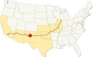
Location of Santo Domingo on Route 66
The climate in Santo Domingo is semi-arid, it has cold winters and hot summers. Altitude and the dry air cause large the daily temperature swings of around 25°F (14°C).
The average high temperature in Summer (July) is 85.9°F (29.9°C), and the average low is about 54.4°F (9.7°C). The winter average high is (Jan) 43.5°F (6.4°C) and the avg. low is about 17.5°F (-8.1°F).
Rainfall is scarce, 14.2 in (360 mm) per year. Most falls during summer (June to late Sept.) during the "North American Monsoon". There are roughly 65 days with precipitation per year.
Snow falls between October and March with up to 23 inches (58 cm) yearly.
Tornado risk
The tornado risk in Santo Domingo is nil, there are no Tornado watches in the county.
Tornado Risk: read more about Tornado Risk along Route 66.
Map of Route 66 in Santo Domingo, NM
Check out our interactive custom map showing Route 66's 1926-32 alignment in Santo Domingo, and the later 1932-37 alignment that bypassed it further east, where I-25 now runs.
The original Route 66 was aligned through Santo Domingo in 1926 along three previous highways, the "Ozark Trail", the "Santa Fe Trail" and the "National Old Trails".
These highways were known as "Auto Trails" and part of a public demand for "better roads": a movement that lobbied for good highways that could be used by motor vehicles, and also signs to mark them and help drivers to find their destination. New Mexico authorities improved the original Ozark Trail in 1914 and designated it as New Mexico State Highway 3. The thumbnail map (Click to see large size map), shows some of the "Auto Trails" that could be used by cars in 1912 in the area near Santo Domingo (it appears as "Domingo" upper right side); the trails are marked with red lines.

1912 Road map, western NM
Click on image to enlarge.
Source

1925 Road map, western NM
Click on image to enlarge.
Source
The second thumbnail map above from 1925 (click on it to see the full sized map) shows the roads that existed one year before Route 66 was created.
Those marked "22" (National Old Trails Rd., coming from Los Angeles) and "32" (New Santa Fe Rd.) with white letters in a black box, went from Gallup to Albuquerque and through Santa Fe. Highway "50" was the Ozark Trails.
The only paved sections (full black line) were between Albuquerque and Bernalillo, and Albuquerque and Tijeras. The highway from Bernalillo to Santa Fe, and beyond Isleta was "improved" (dashed line), the rest were either graded or dirt roads. Domingo is above San Felipe on the upper right side of the map.
The Santa Fe Loop (1926 - 1937)
This was the first alignment of Route 66, from Santa Rosa to Albuquerque via Pecos and Santa Fe.
We describe this segment in our Santa Fe Loop page, a dedicated webpage, with the full alignment, from Santa Rosa, through Dillia, Pecos, Santa Fe, Santo Domingo, and Bernalillo all the way to Albuquerque.
This original highway also continued beyond Albuquerque to Isleta, Peralta and Mesita.
Domingo is on the upper left side:
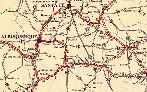
1937 Realignment of Route 66
A political dispute between New Mexico Governor A. T. Hannett and local politicians led to the realignment of Route 66 in 1937.
Hannett blamed the local party bosses when he lost his 1927 bid to re-election. He decided to punish them, and their backers (the business men in Santa Fe) so he quickly had state highway #6 built, in 1927, to link Moriarty with Albuquerque. This highway bypassed the capital city, and was 90 miles shorter for those driving from the east to Albuquerque.
In 1937, the Federal roadbuilders decided to realign Route 66 using Hannett's road, and paved it. It was a straighter highway, and only had a short mountain segment across the Sandia Mountains between Sedillo, Tijeras and Carnuel.
Route 66 Alignment near Santo Domingo
With maps and full information of the alignments of Rte. 66.
- Albuquerque to Lupton (next)
- Santa Rosa to Albuquerque 1937-85 (parallel)
- Tucumcari to Santa Rosa (previous)
The Santa Fe Loop (1926 - 1937)
Our Santa Fe Loop page describes the complete 1926 to 1937 alignment of Route 66 from Santa Rosa to Albuquerque through Pecos, Santa Fe and Bernalillo.
Santo Domingo: its Attractions
Landmarks, Route 66 sights
Kewa Pueblo (Santo Domingo) is a traditional Pueblo village with Native American handicrafts and jewelry. The old pueblo with its ceremonial dances is the main attraction as is the Old Santo Domingo Trading Post on the 1926-1932 Route 66 alignment.
We will drive from Santa Fe westwards to Santo Domingo. The original colonail highway, the Camino Real and the first Route 66 alignment followed a course that still exists (dirt trail, very bad road!) and that descended from the high mesa on which Santa Fe is located to the lower Rio Grande valley at La Bajada (Spanish for "The Descent"), with a series of sharp hairpin bends on a steep incline.
Bajada de Santa Fe
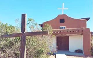
San Miguel - St. Michaels church, La Bajada. Source
The village of La Bajada. Stop by its austere adobe church, San Miguel Arcángel built in 1837, and cemetery. Restored in the 1960s. The village was established between 1695 and 1737 as a rest stop along the "Camino Real" or Royal Highway that linked Santa Fe with Mexico City at the base of a 600 foot (183 m) escarpment.
It was located on a native road which later would be used as a U.S. territorial wagon road (1860s), and become the NM-1 highway and the National Old Trails highway (1909).
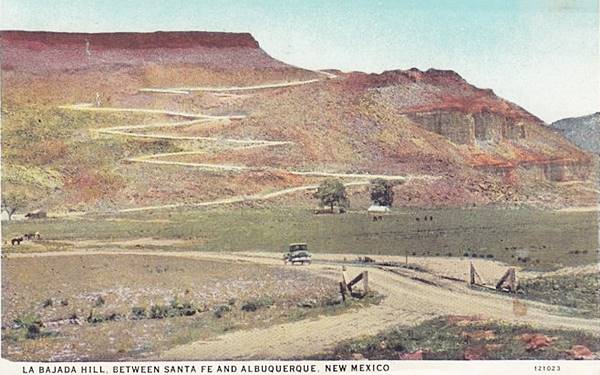
Camino Real at La Bajada
The Spanish Camino Real (Royal or King's Road) reached La Bajada from Santa Fe and Santo Domingo. The road linked the colony with Mexico City. La Bajada was a tall black basaltic escarpment, the edge of a mesa that marked the border between the Rio Abajo (downstream) and Rio Arriba (upstream) provinces of New Mexico.
The trail forked here, one headed east and around this barrier, while the main trail crossed the plain north of San Felipe to the opening of the Santa Fe Canyon, this corridor was like a great mouth (and it was named Cañon de Las Bocas - Canyon of the Mouths).
There had been a large Tano pueblo here. The road ran up the canyon crossing a stream several times all the way to La Cienaga (the bog) an onwards to Santa Fe.
There was a shorter trail used by those riding on horseback and by pack mules, a winding trail up the steep slope of La Bajada. The pack trail was improved by the U.S. Army in the 1860s to that wagons could use it.
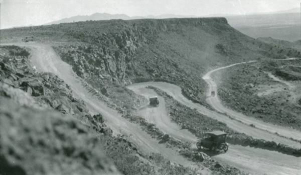
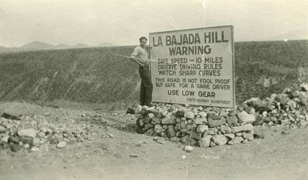
There is a steep zig-zag road that climbs from the lower mesa (La Majada Mesa) to the upper one (La Bajada Mesa), which became part of US 66 and US 85 when they were aligned through here from 1926 to 1932. There were very steep grades (up to 15 percent) on the climb, with switchbacks and dangerous curves. In 1932 it was paved and shortened and carried US 66 until 1937. We describe both alignments below.
La Bajada alignment (1926-32)
>> navy blue lines in our custom map is the 1926-32 US66 at La Bajada.
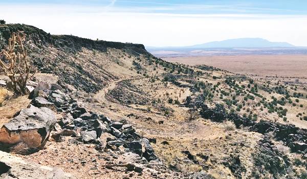
There is a steep rough dirt zig-zag road with dozens of hairpin bends that climbs from the lower mesa (La Majada Mesa) to the upper one (La Bajada Mesa). This winding road became part of US 66 and US 85 when they were aligned through here in 1926. There were very steep grades, and it is overgrown and strewn with boulders. It has switchbacks and dangerous curves (Further reading).
This is a map with directions from Santa Fe to the top of the Bajada. And this is a map with directions from Santa Fe to the bottom of the Bajada.
West of La Bajada
The old alignment meets paved Tetilla Peak Rd., there is a marker (St. view) with information about La Bajada and its historic context; it reads: "This black volcanic escarpment is one of New Mexico's most important landmarks. The descent (bajada) of this escarpment marked the traditional division between New Mexico's upper (Rio Arriba) and lower (Rio Abajo) districts. Over the centuries, several trails and roads were developed to overcome this most difficult of obstacles along the Camino Real."
West of this point there is a gap in the alignment (black line in our map) towards Domingo.
After the gap is a rough dirt road that can be driven, Indian Service Rte 841 to Domingo, close to Santo Domingo where it meets Indian Service Rte 88 (violet line).
There are the remains of an old Route 66 bridge (red marker) behind the Trading Post of Domingo, on Galisteo Creek.
Domingo
The community of Domingo, located 3 miles east of Santo Domingo Pueblo grew up around the railroad depot of the AT&SF railroad. It had a post office from 1909 to 1940. It grew rapidly with 1,000 residents by 1884. It was first named Wallace after a former governor, the Post Office was called Annville , then it became Thornton (another governor) and finally Domingo after the neighboring pueblo. Over the years its population dwindled as the railroad carried less passengers and road travel replaced it.
Rail Runner to Santa Fe and Albuquerque
You can ride the train all the way to and from Santa Fe or Albuquerque and visit Kewa Pueblo.
Full details on time tables and ticketing at the Official website Rail Runner.
Santo Domingo Trading Post
Listed in the National Register of Historic Places
The trading post is located on former Route 66, east of the Pueblo; a classic Curio & Trading Post.
Santo Domingo Trading Post in 1971
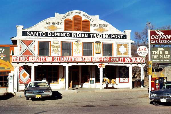
It is located on the north side of Indian Service Road 88 in Domingo, NM.
This is a typical 1920s Indian Trading Post built to cater to tourists arriving on the Atchison, Topeka and Santa Fe Railroad, opposite the Domingo railroad depot (where the modern Rail Runner depot is now located).
The trading post was opened before Route 66 was created; the Seligmans opened their store in 1922. The road that passed between the post and the tracks would become Route 66 in 1926 and it brought a growing flow of travelers to their store.
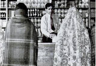
1943 view of the Trading Post's interior. Life
The adobe building has two stories and was built in Mission Revival Style. Behind it was an even older warehouse built in 1880; it had been the first trading post in the area.
It was a typical curio shop selling Native American souvenirs to tourists and gasoline. But it also traded with the local tribal residents at Kewa providing food and goods to them.
When the highway was realigned and straightened in 1932 traffic dropped and when the "Santa Fe Cut-off" was concluded in 1937 traffic dropped even more; sales to tourists fell.
The image (click to enlarge) from Life Magazine November 29, 1943 issue, is captioned "Storekeeper Miguel ("Mike") Leyva owns trading post at Santo Domingo where Indians barter grain, jewelry, other produce for things to eat and wear". In 1946 Leyva sold it to Fred Thompson who focused his business on sales to the locals. After his death in 1995 it closed.
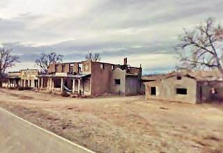
Burned ruins of Domingo Trading Post, 2007. Click for St. view
The historic trading post is 2.7 miles east of the Santo Domingo Pueblo along Indian Service Road 88 and 3.5 mi from the freeway; Map with directions from I-25.
President John F. Kennedy is said to have visited it during his 1962 visit to New Mexico atomic research sites, but we haven't found any proof (Source).
Fred Thompson owned it from 1946 until his death in 1995.
A fire almost burned the place down in 2001 and destroyed the 1880 warehouse and the sign that boasted that it was "The Most Interesting Spot in the Old West... Where Real Indians Trade."
Under the Route 66 Corridor Preservation Program funds were secured to stabilize the building in 2007 and a grant allowed the complete restoration of the structure, its facade, interior, glazing, balconies and flooring. Below is a "Then and Now" sequence by Spears Horn Architects who were in charge of the restoration project.
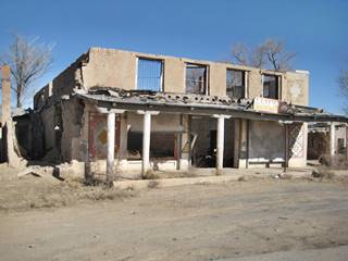
Domingo Trading Post before restoration. Source

Domingo Trading Post after restoration. Source
Pueblo of Santo Domingo (Kewa Pueblo)
West of Domingo Trading Post, on NM 22, is Kewa Pueblo, NM.
Listed in the National Register of Historic Places
The adobe pueblo has been inhabited by Native Americans for centuries, and later colonized by the Spanish in 1598. A historic and traditional village.
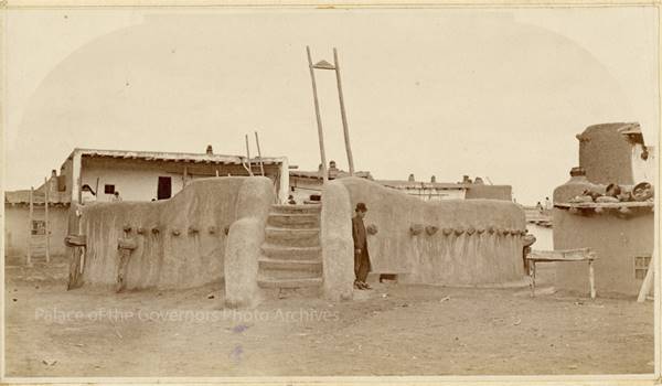
The original pueblo was built around a central Plaza but the flooding by the Rio Grande destroyed the village and after the devastating 1886 flood, it was rebuilt further east. The pueblo now has a wide central street with long blocks of houses (built in adobe) lining it.
The surviving buildings were incorporated into the new town which has two "Kivas", circular ceremonial rooms. The Catholic church built in Mission-style is located on the edge of the Pueblo.
Below is a picture of the original kiva and pueblo with archaeologist Adolph Francis Alphonse Bandelier (1840 – 1914) standing beside it.
Important rules of etiquette during your visit to a Pueblo
Pueblos are on tribal lands and the local customs, religion and traditions must be respected.
- Check that access is allowed (leaders may restrict access for private ceremonies) and be prepared to pay an access fee
- Photography. Taking photos may be totally prohibited or a permit may be required. Check with the Tribal Office. Even if you have a permit, always request permission before taking a photo of a tribal member. Leave your cell phone out of sight and silence it, as it could be confiscated
- Don't litter. Don't carry or use alcohol or drugs
- Lock vehicles, the pueblo is not responsible for any damages.
- "Off Limits" signs must be respected. Don't remove artifacts or pottery shards
- Don't speed. Respect traffic signs
- Respect the local people. Dances are not a show, they are a ceremony. Show respect and remain silent at all ceremonies
- Cemeteries, Kivas, ceremonial rooms are sacred places and entry is not allowed for non-Pueblo people
Traditional Native Dances
For thousands of years the ancestors of the Pueblo Indians have farmed the soil of New Mexico, and their ceremonies seek to achieve a cosmic balance and obtain the life-giving rain for their crops, something critical in the arid environment of New Mexico.
The "Kachinas" are immortal beings that bridge the gap between the spiritual and real worlds and are key religious figures.
The two main events are the Corn Dance in August and the Hunting Dance in February. Don't miss them.
August 4th: Santo Domingo day
This is the day that honors Santo Domingo (St. Dominic), the town's patron saint and it is the Pueblo's annual feast day. The pueblo people participate with their Corn Dance.
Vintage 1940s postcard showing the Corn Dance at Kewa Pueblo
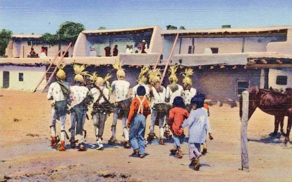
The postcard above was printed during the 1940s, and its caption reads: "Santo Domingo Pueblo NM - The Koshare in the Corn Dance". The description on its back says:
According to the ancient legend, when the Indians first came into this country, they were almost overcome by hunger and thirst. The Gods, in order to make them forget their privation, painted one of their number white and decorated him most fantastically, and then caused him to dance and cut up capers before the exhausted people, who, on seeing him broke into laughter and once more took courage. This man, they called "Koshare" (i.e. Dancing-Man, or as Bandelier calls him, Delight-Maker). The Koshare of the present day are an Indian secret society and have since prehistoric times been very influential. During certain Indian dances, they paint up as the first Koshare did long ago, to the great delight of the Indians present.
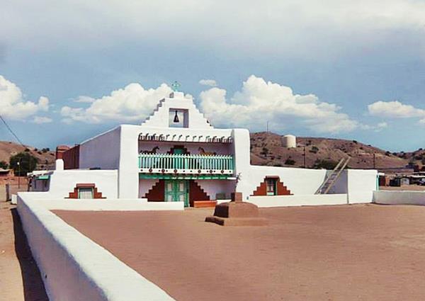
Santo Domingo Church
It is located on the eastern side of the pueblo (St view)
The mission church at Santo Domingo has changed over the centuries. The original church was built here in 1607 by Juan de Escalona; in 1619 it became the seat of the religious officers of the province. It was rebuilt before the Pueblo Revolt of 1696, that destroyed it. After the rebelion was crushed, the pueblo was moved to its current location, and a new church was built in 1706.
Around 1750 a second, larger church was built beside it by Father Antonio Zamora. So the pueblo had two churches side by side facing the plaza-atrium surrounded by a low adobe brick wall. The old church was used for burials. The two churches can be seen in the picture taken in 1880, below. Notice the bell arch
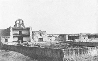
Santo Domingo churches in 1880. Source. Click image to enlarge
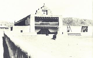
Santo Domingo church in 1917. Source. Click image to enlarge
The pueblo was close to the Rio Grande and its floods periodically damaged the village and churches. Although levees had been built, the flood water eventually destroyed the curches and cemetery washing them away on in June 1886.
Reconstruction began ten years later at a new site further east, further from the flood area. It was the work of Father Dumarest who replicated the original design, as the local congregation didn't want to modernize the design.
Museum
Visit the Museum and the Cultural Center too.
Arts and Native Crafts
The Labor Day weekend is when the annual Santo Domingo Arts and Crafts Market is held. Over 350 local artists and craftsmen and women exhibit and sell their work.
The local artisans are best known for their hishi, pottery and turquoise jewelery.
The 1932 - 1937 Route 66
"La Bajada" and Domingo bypassed
In the early 1930s the road between Domingo and Santa Fe was straighened out and the dangerous hairpin Bajada into the Santa Fe River Canyon was bypassed. The road followed the current alignment of U.S. 85 (I-25) from Cerrillos Road in Santa Fe to Algodones beyond Domingo.
The yellow line in our custom map is the driveable alignment, mostly as the freeway's frontage Rd. The green line shows the alignment buried when I-40 was built over it. The black line by Exit 264 shows a ghost alignment that is still visible beside I-25.
Santo Domingo was relegated by the new alignment.
>> 1932-37 US 66 west of Santa Fe (green, yellow and black lines).
The original 1926-32 alignment west of Domingo Trading Post follows the course shown with violet and black lines. The first section (violet) can be driven, the rest is a rough dirt trail unfit for driving.
Both 1926-32 and 1932-37 alignments meet at the The Mormon Battalion Monument and continue westwards overlaid by the freeway (green line) to San Felipe's Main St. where they resurface along the Camino Real.
End of this leg of your Road Trip
This marks the end of this leg of your journey. Continue your road trip by heading west to your next stop on your road trip: Algodones, a farming community in the Rio Grande river valley, located less than 3⁄4 miles from the Rio Grande.

Sponsored Content

>> Book your Hotel in Albuquerque

Credits
Banner image: Hackberry General Store, Hackberry, California by Perla Eichenblat
NPS, Kewa Pueblo
Barry Pritzker, A Native American Encyclopedia: History, Culture, and Peoples. pp. 88
Kim Suina, Santo Domingo Pueblo
Robert Julyan. 1996, The Place Names of New Mexico, UNM Press.


