Route 66 in Las Vegas NM
Index to this page
About Las Vegas, New Mexico
Facts, Trivia and useful information
The Other Las Vegas
Elevation: 6,424 ft (1,958 m). Population: 12,723 (2025).
Time zone: Mountain (MST): UTC minus 7 hours. Summer (DST) MDT (UTC-6).
Las Vegas is not located on Route 66 but is only six miles north of the original 1926 to 1937 US 66 alignment that linked Santa Rosa with Albuquerque through Santa Fe along the Santa Fe Trail.
Las Vegas New Mexico is the county seat of San Miguel County and combines two once separate towns: west Las Vegas ("Old Town") and east Las Vegas ("New Town").
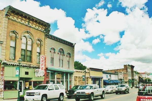
Downtown Las Vegas New Mexico
History
New Mexico has been inhabited for over than 10,000 years (the site at Sandia Cave, southwest of Las Vegas is proof of this). More recently, around 900 AD the Pueblo people settled in the valleys of the rivers that flowed south from the Rocky and Sangre de Cristo Mountains.
There were many Pueblo villages west and south of Las Vegas on the Pecos River such as the pueblos in Pecos and Aurupa.
The first European to explore the area was Francisco Vásquez de Coronado in 1540, who named the native people "Pueblo", after the Spanish word for "village." They explored the prairies east of Las Vegas.
In 1598, Juan de Oñate conquered the territory for Spain and occupied the Pueblos. However Las Vegas region was not actively settled for almost 230 years; it was too far from the capital at Santa Fe across the Sangre de Cristo Mountains and its location on the foothills next to the Great Plains exposed it to the raids of the Comanches and Apaches. It was however a strategic trade route linking New Mexico with the east, and the Santa Fe Trail passed through the area.
After Mexico won its independence from Spain in 1821 the meadows in this area attracted Mexican settlers in the 1830s who founded Las Vegas.
The Name: Las Vegas
The Spanish words Las Vegas means simply: "The Meadows". And it is very appropriate description of this area.
At the time of the Mexican independence from Spain (1821), Luis María C. de Baca requested a land grant along the Gallinas River (by the way, gallinas means: "chickens" in Spanish). He specifically requested the tract of land known as "Vegas Grandes" (Large Meadows). The grant was approved in 1823 but occupation was slow due to the raids from the Indians that lived in the area.
By 1831 Baca had built a small ranch and bred sheep in the meadows. In 1833 a second group of settlers from neighboring San Miguel del Bado made a petition for land, which was granted on the condition that a Plaza be built in the village.
This was the origin of "West Las Vegas" or the "Old Town," established on the western side of the Gallinas River. The town was founded as "Nuestra Señora de los Dolores de Las Vegas" (Our Lady of Sorrows of the Meadows), a very long name quite typical among Spanish towns. It was shortened to "Las Vegas". The town was placed under the patonage of the Virgin Mary (Our Lady of Sorrows) and a church was built on the main square or Plaza.
At the time of the Mexican-American War (1846-48), it had about 100 houses. During the war, the The Mormon Batallion led by General Kearny passed through the town and it became the headquarters of the American forces.
Kearny's Proclamation
General Kearny took posession of New Mexico for the United States in 1846 and proclaimed it to the local population from a roof-top that overlooked the Plaza in Las Vegas.
Once it became part of the United States, more traffic flowed along the Santa Fe Trail; Las Vegas became an important a trading center and stopover.
When the Atchison, Topeka and Santa Fe Railway reached Las Vegas in 1879 it built its depot one mile east of the old town. The railway also attracted a horde of ill-doers and Las Vegas became a violent and crime-ridden town, but law was enforced in the Old-West style and many bandits were hung on a windmill in the center of the plaza. Some Wild-West icons came through the town: Jesse James, Billy the Kid and Wyatt Earp were among them.
Two towns in Las Vegas
The Railroad chose to build its own town and develop it one mile to the east of the Old Town, across the Gallinas River. So there were two separate towns with the same name: East and West Las Vegas. They have now been combined into one city but, there are still two separate school districts.
In 1926, Route 66 was aligned along the Ozark Trail through Romeroville (right beside Las Vegas) and westwards, along the Old Santa Fe Trail. Route 85 also followed the Santa Fe Trail and headed north through Las Vegas. It was the most important town for those travelling the Mother Road between Santa Fe and Santa Rosa and it provided a wide variety of services to the travelers.
But in 1937 US 66 was realigned further south, when the "Santa Fe cut-off" shortened the road. An improved alingment with an east-to-west course from Santa Rosa to Albuquerque, bypassed Las Vegas.

Where to Stay; your Hotel in Las Vegas
There are plenty of lodging options in Las Vegas:
> > Book your room in Las Vegas NM
Lodging Near Las Vegas along Route 66
Below you will find a list of some of the towns along Route 66 in New Mexico. Click on any of the links to find your hotel, motel or accommodation in these towns (listed from east to west):
On Route 66's Main alignment
The Santa Fe Route 66 segment
Eastwards
Westwards
>> There are RV campgrounds in Las Vegas
The weather in Las Vegas
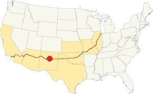
Location of Las Vegas on Route 66
Summers in Las Vegas NM are warm and winters quite cold. The area is dry and relative humidity is low.
The average summer high (Jul) is 83°F (28.3°C) and the low average is 52°F (11.1°C). In winter (Jan) the average low and high are: 22°F (-5.5°C) and 46°F (7.8°C) respectively.
Rainfall is higher during the period between May and Nov. (13 in.-330 mm). The average rainfall is 16.5 in. per year (419 mm).
There are 272 sunny days and 62 precipitation days per year in this sunny and dry town. Snowfall is around 27 in. per year, and falls between Nov. and March.
Tornado risk
Las Vegas is located in an area with virtually no tornado risk: San Miguel county only has two (2) Tornado watches per year and mostly in the eastern fringe of the county.Tornado Risk: read more about Tornado Risk along Route 66
Map of Route 66 in Las Vegas, NM
Visit our The Santa Fe Loop (1926-37) alignment page for a detailed description of Route 66 in this area. Below is the color coded interactive map:
>> Custom map of Route 66 in town
The original Route 66 was aligned through Santa Fe in 1926 along three previous highways, the "Ozark Trail", the "Santa Fe Trail" and the "National Old Trails".

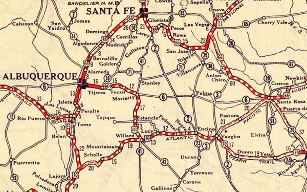
1925 Road map, Central NM
Click on image to enlarge.
Source
The thumbnail map above from 1925 (click on it to see the full sized map) shows the roads that existed one year before Route 66 was created.
Notice "Las Vegas" on the center-right side of the map.
Those marked "22" (National Old Trails Rd., coming from Los Angeles) and "32" (New Santa Fe Rd.) with white letters in a black box, went from Gallup to Albuquerque and through Santa Fe.
The only paved sections (full black line) were between Albuquerque and Bernalillo, and Albuquerque and Tijeras. The highway from Bernalillo to Santa Fe, and beyond Isleta was "improved" (dashed line), the rest were either graded or dirt roads.
The Santa Fe Loop (1926-1937)
This was the first alignment of Route 66, from Santa Rosa to Albuquerque via Pecos to Santa Fe.
We describe this segment in our Santa Fe Loop page, a dedicated webpage, with the full alignment, from Santa Rosa, through Dillia, Pecos, Santa Fe, Santo Domingo, and Bernalillo all the way to Albuquerque.
This original highway also continued beyond Albuquerque to Isleta, Peralta and Mesita.
Las Vegas appears in this map (right side)
1937 Realignment of Route 66
A political dispute between New Mexico Governor A. T. Hannett and local politicians led to the realignment of Route 66 in 1937.
Hannett blamed the local party bosses when he lost his 1927 bid to re-election. He decided to punish them, and their backers (the business men in Santa Fe) so he quickly had state highway #6 built, in 1927, to link Moriarty with Albuquerque. This highway bypassed the capital city, and was 90 miles shorter for those driving from the east to Albuquerque.
In 1937, the Federal roadbuilders decided to realign Route 66 using Hannett's road, and paved it. It was a straighter highway, and only had a short mountain segment across the Sandia Mountains between Sedillo, Tijeras and Carnuel.
Route 66 Alignment near Las Vegas
With maps and full information of the alignments of Rte. 66.
- Albuquerque to Lupton (next)
- Santa Rosa to Albuquerque 1937-85 (parallel)
- Tucumcari to Santa Rosa (previous)
The Santa Fe Loop (1926-1937)
Our Santa Fe Loop page describes the complete 1926 to 1937 alignment of Route 66 from Santa Rosa to Albuquerque through Pecos, Santa Fe and Bernalillo.
Las Vegas: its Attractions
Landmarks and sights
The landmarks mentioned below can be visited either by car or walking. The Walking Tour Map with directions, shows the itinerary to see all sights. Total distance 1.4 miles.
Begin your visit at the Old Town square.
The Old Plaza
The historic town square, that dates back to the 1830s.
The Old Town Plaza was the center of the original village. It was the Old Town's market, and the goods carried by the freight wagons along the Santa Fe Trail were unloaded here. The Jail and first courthouse were built next to the plaza and Billy the Kid was imprisoned in it after being captured.
A windmill erected in the center of the plaza served as gallows in the late 1870s to hang outlaws. It was later replaced by a bandstand.
Billy the Kid
Henry McCarty a.k.a. Billy the Kid, (1859-1881) was a gunman and outlaw who reputedly killed 21 men.
Around the Old town square you will see some interesting landmarks.
Demarais House-Our Lady of Sorrows Parish Hall
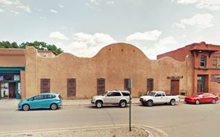
At 1810 East Plaza, Las Vegas. This historic adobe building was built prior to 1882. The undulating wall was added in the 1930s. It serves as a Parish Hall.
Plaza Hotel
230 Plaza Park, Las Vegas, NM.
Listed in the National Register of Historic Places & U.S. National Historic Landmark
A historic hotel built in 1882 on the Old Town Plaza, site of many historic events.
Rough Riders
The Rough Riders was a vounteer cavalry unit organized during the 1898 Spanish-American War. It was commanded by Teddy Roosevelt, a promoter of the American
involvement in the war, which led to Cuban independence from Spain.
Theodore Roosevelt (1858-1919) was the 26th U.S. President between 1901 and 1909. And he stayed twice at the Plaza; he also announced his bid for the presidency in Las Vegas.
The hotel was built on the north side of the historic Plaza. The three-story Italian-style brick building was nicknamed the "Belle of the Southwest".
Charles Ilfeld opened a three-story department store next to the hotel (the village of Ilfeld, on Route 66 west of Las Vegas was named after Charles).
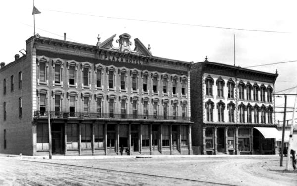
Las Vegas has a dry climate which drew many people suffering from lung disease, especilly tuberculosis (TB). The Plaza lodged many people struck with TB.
Theodore "Teddy" Roosevelt's Rough Riders held their first reunion in the hotel in 1899.
The hotel was restored by new owners in 1982 and is still operational; pictured below.

Our Lady of Sorrows Church
Head west from the Plaza and visit the Old Las Vegas Parish church at W. National Ave.
The original Las Vegas church was erected in 1836 on Church Street, one block east of the current church. The parish was established in 1851 and a new building was planned in Gothic Revival style. Construction began in 1862 and took seven years to be completed. It employed stone quarried in Anton Chico (25 mi. away). It has two towers and the red sandstone was laid in ashlar pattern.
Church St. was in those days the "Red Light District", brothels and saloons lined the street, known as "Sodomía" or "Amargura" (Bitterness), a clear reflection of its sordidness.
Leave the Plaza and head east along Bridge St., named so because it had the bridge across the Gallinas River and follow it as it becomes National Ave.
Carnegie Library
Ahead, at 500 E National Ave. Las Vegas, NM. is the only surviving Carnegie Library in the whole state. It was built in 1904 as a donation by Andrew Carnegie.
It stands in the middle of a park and has a Monticello-like style or Neo-Classical Revival style (St. view).
Old City Hall
New Mexico's first municipal building.
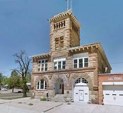
From the Library, head south along 6th St. and visit another historic building at 626 6th St. The old City Hall was built in 1892 in Italianate Romanesque design by the Denver firm of Kirchner and Kirchner. It served the city for nearly a century before the new City Hall was built one mile north.
Just east of this building is the museum.
City of Las Vegas Museum and Rough Rider Memorial Collection
727 Grand Ave. A large collection of the Rough Riders photos, archives and artifacts relating to the 1898 Cuban Campaign of the Spanish-American War and to the local history. The museum is housed in a historic stone building with a Pueblo Revival style built in 1940 under the Works Progress Administration program.
La Castañeda Hotel
Head towards the old railway depot to visit a historic hotel at 524 Railroad Ave. A luxurious Harvey House hotel in 1898 beside the railway depot.
Harvey House
Frederick Henry "Fred" Harvey (1835-1901) was a businessman who developed the concept of efficient and clean service for those travelling by rail. So he signed agreements with the main railroad companies and built lunch rooms, diners, restaurants, hotels, and souvenir shops. They were known as the "Harvey Houses". The Atchison, Topeka and Santa Fe Railway was one of the companies he served so his hotels can be seen across New Mexico right beside their depots.
This hotel in Las Vegas was one of the first to be built in Mission Revival style.
Tours & Itineraries plus outdoor Fun
Just north of Las Vegas is Montezuma, a renown spot since the late 1800s.
Montezuma
The name is a deformation of Moctezuma (1466-1520, the sovereign of the Aztec Empire who was killed by Hernán Cortés when the Spanish conquered
5 mi. North of Las Vegas along NM-65, on the Gallinas Creek in the foothills of the Sangre de Cristo Mountains. Map with Directions from Las Vegas to Montezuma.
The natural hot springs known by the Spanish as "Los Ojos Calientes" (Hot springs) had been used since prehistoric times by the Native Americans.
In 1840 McDonald obtained a land grant that included the springs and built the first bath house. After the American annexation of New Mexico, an army hospital was built close to the springs. In 1862 it was converted into a hotel that was rebuilt in stone in 1879. Its therapeutic waters attracted many customers (including Jesse James). The "old stone hotel" still stands and is part of the United World College-USA.
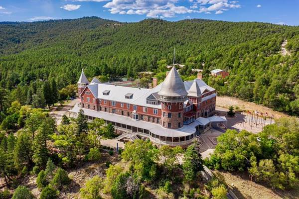
The Atchison, Topeka and Santa Fe Railway reached Las Vegas in 1879 and in 1882 built a large hotel and linked it to the main line with a narrow-gauge railroad. It renamed the town "Montezuma." The first hotel burned down, as did a second one built to replace it. The final third hotel was designed to resemble a French chateau in stone and slate. It opened in 1886, and is pictured below; it can still be seen. It closed in 1903. Between 1937 and 1972 it was a Catholic seminar.
The third Montezuma castle
National and State Parks
Storrie Lake State Park
Only 5 mi. north of Las Vegas. See Map with directions.
It is a tranquil lake ideal for fishing, windsurfing and bird-watching. There are many campsites and hookups for RVs.
For more details visit the Park's Website.
Fort Union National Monument
29 mi. north of Las Vegas (along I-25 and NM-161), see a Map with directions.
The U.S. Army built three forts here in 1851, 1861, and 1863-68. The forts were built here by a fork in the Santa Fe Trail as it was a strategic siteaer. It protected wagons and settlers from the Indian attacks and during the Civil War protected New Mexico from the Confederates.
Use the self-guided trail through the ruins of the fort (abandoned in 1891) and see the "Ruts of the Santa Fe Trail wagons." Full details at the park's Website.
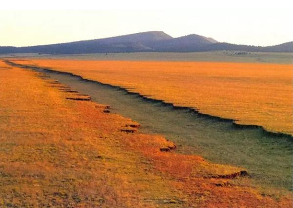
Las Vegas National Wildlife Refuge
6 mi SE of Las Vegas via NM-104 and NM-281. See the Map with Directions
Drive the Auto-loop (8 mi.) or walk the short self-guided nature trails to glimpse the wildlife, flowers and great views of the Mountains and Crane Lake.
End of this leg of your Road Trip
This marks the end of this leg of your journey. Continue your road trip by heading west, passing Romeroville, and visiting the next stop: Tecolote.

Sponsored Content

>> Book your Hotel in Albuquerque

Credits
Banner image: Hackberry General Store, Hackberry, California by Perla Eichenblat


