Route 66 in Glorieta NM
Index to this page
About Glorieta, New Mexico
Facts, Trivia and useful information
Elevation: Elevation: 7,431 ft (2,265 m), Population: 549 (2025).
Time zone: Mountain (MST): UTC minus 7 hours. Summer (DST) MDT (UTC-6).
Glorieta is a small populated area in Santa Fe County, New Mexico. It is located 5 miles west of Pecos along NM-50 (former 1926 alignment of Route 66 between Pecos and Santa Fe).
The village is located at the point where the road takes a sharp turn and changes course from a NW to a SW alignment as it crosses the mountains.
History
This area of New Mexico has been inhabited for over 10,000 years (the nearby site at Sandia Cave is proof of this). Later the Pueblo people settled in the valleys of the rivers that flowed from the Rocky Mountains like the Pecos river and Glorieta Creek. Two miles east of Glorieta are the remains of the site of Arrowhead Pueblo.
Spanish conquistador Francisco Vasquez de Coronado explored the area, reaching neighbouring Pecos in 1540 but he didn't cross Glorieta Pass, he came from the southwest from Galisteo. They claimed this territory for their king, and it became a Spanish colony in 1598, part of the New Spain viceroyalty with its capital in Mexico City.
The natives expelled the Spanish in 1680 during the Pueblo Revolt, but they returned in 1692 and defeated the rebels.
The southern fork of the Santa Fe Trail passed through Las Vegas abd before reaching Santa Fe, crossed the southern tip of the Sangre de Cristo Mountains via Glorieta Pass; the trace was also known here as the Old Pecos Trail.
Settlement in the area was slow and a formal land grant was approved in 1815 for the "Cañon de Pecos" which was awarded to Juan de Dios Peña.
In 1821 it became part of the territory of an independent Republic of Mexico. But Mexico ceded the territory to the U.S after being defeated during the Mexican - American War (1846-48).
Wagon trains with goods and settlers heading west used this road and there was a stop just before the pass' summit, on its eastern side, at Pigeon Ranch, which belonged to Mr. Valle, who had settled there in the 1850s.
During the Civil War, the Confederate troops fought a battle with the Union forces in Glorieta (1862) and in Apache Canyon.
The Atchison, Topeka and Santa Fe Railway built its tracks along the Santa Fe Trail in the early 1880s and established a station at Glorieta. The railroad replaced traffic along the Santa Fe Trail.
The name: Glorieta
There was a post office at the place known as "La Glorieta" from 1875 to 1880. After that it changed to "Glorieta" (dropping the article "La").
The word Glorieta has several meanings in Spanish, but the most appropriate seems to be that of a square or plaza where several roads meet; Glorieta was a main point where roads converget to cross a pass.
In 1926, Route 66 and US 85 were aligned through the Glorieta Pass. Route 66 was realigned further south in 1937, from Moriarty to Santa Rosa, and it bypassed all the towns along the Santa Fe Loop including Glorieta.

Accommodation near Glorieta
There are plenty of lodging options for those traveling along Route 66
> > Book your room nearby in Santa Fe
More Lodging Near Glorieta along Route 66
Below you will find a list of some of the towns along Route 66 in New Mexico. Click on any of the links to find your hotel, motel or accommodation in these towns (listed from east to west):
On Route 66's Main alignment
The Santa Fe Route 66 segment
Eastwards
Westwards
>> There are RV campgrounds near Glorieta in Santa Fe
The weather in Glorieta
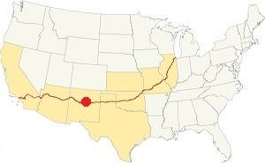
Location of Glorieta on Route 66
Glorieta has hot summers and cold winters, the area is quite arid and dry.
The average high in summer (July) is 86°F(30°C) and the average low is 53°F (11.7°C). During winter (Jan) the average high is 48°C (8.9°C) and the average low is 21°F (-6.1°C), below freezing point.
Snowfall is around 25 inches (63.5 in.) on average and can fall at any time between November and April. Most falling during Dec. and Jan (6 in. each), rainfall is 17.2 in. per year (437 mm). Most rain falls from June through Sept. with almost 10 inches (250 mm) of rain.
Tornado risk
Glorieta is a region with almost zero tornado risk: San Miguel county only has two (2) Tornado watches per year and mostly in the eastern fringe of the county.
Tornado Risk: read more about Tornado Risk along Route66.
Map of Route 66 in Glorieta, NM
The violet line in our custom map shows the alignment of US 66 across Glorieta and towards Santa Fe.
The original Route 66 was aligned through Santa Fe in 1926 along three previous highways, the "Ozark Trail", the "Santa Fe Trail" and the "National Old Trails".

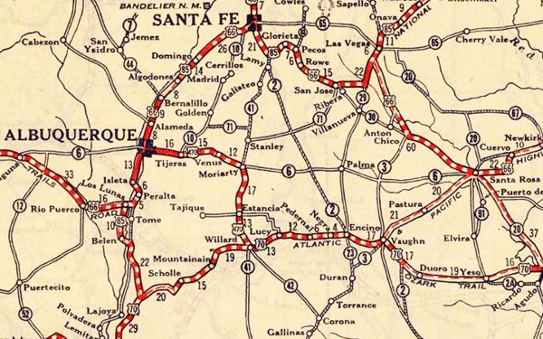
1925 Road map, Central NM
Click on image to enlarge.
Source
The thumbnail map from 1925 (click on it to see the full sized map) shows the roads that existed one year before Route 66 was created.
Notice that both Glorieta and Canyoncito appewar on the center-right side of the map.
Those marked "22" (National Old Trails Rd., coming from Los Angeles) and "32" (New Santa Fe Rd.) with white letters in a black box, went from Gallup to Albuquerque and through Santa Fe.
The only paved sections (full black line) were between Albuquerque and Bernalillo, and Albuquerque and Tijeras. The highway from Bernalillo to Santa Fe, and beyond Isleta was "improved" (dashed line), the rest were either graded or dirt roads.
The Santa Fe Loop (1926 - 1937)
This was the first alignment of Route 66, from Santa Rosa to Albuquerque via Glorieta to Santa Fe.
We describe this segment in our Santa Fe Loop page, a dedicated webpage, with the full alignment, from Santa Rosa, through Dillia, Pecos, Santa Fe, Santo Domingo, and Bernalillo all the way to Albuquerque.
This original highway also continued beyond Albuquerque to Isleta, Peralta and Mesita.
See Glorieta on the upper middle part of the map
1937 Realignment of Route 66
A political dispute between New Mexico Governor A. T. Hannett and local politicians led to the realignment of Route 66 in 1937.
Hannett blamed the local party bosses when he lost his 1927 bid to re-election. He decided to punish them, and their backers (the business men in Santa Fe) so he quickly had state highway #6 built, in 1927, to link Moriarty with Albuquerque. This highway bypassed the capital city, and was 90 miles shorter for those driving from the east to Albuquerque.
In 1937, the Federal roadbuilders decided to realign Route 66 using Hannett's road, and paved it. It was a straighter highway, and only had a short mountain segment across the Sandia Mountains between Sedillo, Tijeras and Carnuel.
Route 66 Alignment near Glorieta
With maps and full information of the alignments of Rte. 66.
- Albuquerque to Lupton (next)
- Santa Rosa to Albuquerque 1937-85 (parallel)
- Tucumcari to Santa Rosa (previous)
The Santa Fe Loop (1926 - 1937)
Our Santa Fe Loop page describes the complete 1926 to 1937 alignment of Route 66 from Santa Rosa to Albuquerque through Glorieta, Santa Fe and Bernalillo.
Glorieta: its Attractions
Landmarks, Route 66 sights
Drive westwards from Pecos along NM highway 50, it follows the ancient Native American trail across the mountains following Glorieta Creek. This trail would later become a wagon trail that carried goods and pioneers from the Mississippi to the American Southwest, the Santa Fe Trail.
The Historic Santa Fe Trail
The Spanish settlers in Santa Fe opened the "Santa Fe Trail" in 1792 to link their city with the French trading posts in Louisiana, on the Missouri River. Use was sporadic as the natives on the prairies attacked those moving along it.
Much later in the 1820s the situation improved and wagon trains used it to move merchandise to and from New Mexico. After 1848 once the U.S. Army pacified the natives, it became one of the main trails used by the settlers to reach the Southwest and the coast of the Pacific Ocean.
The southern fork of the Trail passed through Las Vegas, Rowe, and the pueblo of Pecos, crossed Glorieta Pass to reach Santa Fe.
Arrowhead Tourist Camp (gone)
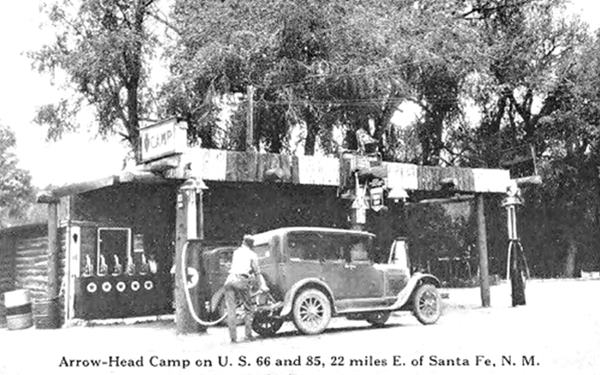
Two miles east of Glorieta, and one half-mile southeast of Pigeon Ranch was a very popular camping spot on the original Route 66 alignment. Thad C. Slaughter who was a Texan (1882-1945) opened it one year after U.S. 66 and 85 were aligned through Glorieta, he ran it with his wife Emma Jane and son Randall. The site had a filling station, a building that served as a lodge with a cafe, several cabins and a campground. It was located on the north side of the highway with Glorieta Creek running just south of the roadway.
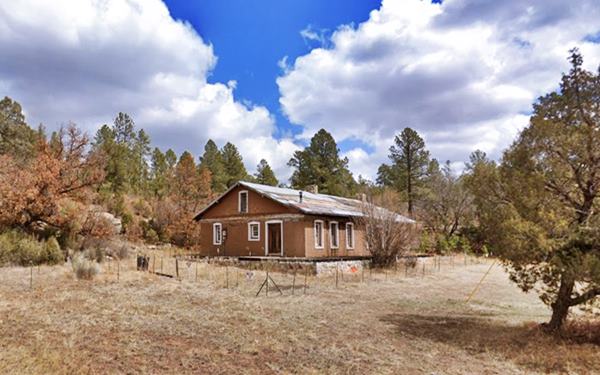
Nothing remains of the site, the last building was torn down in 2022.
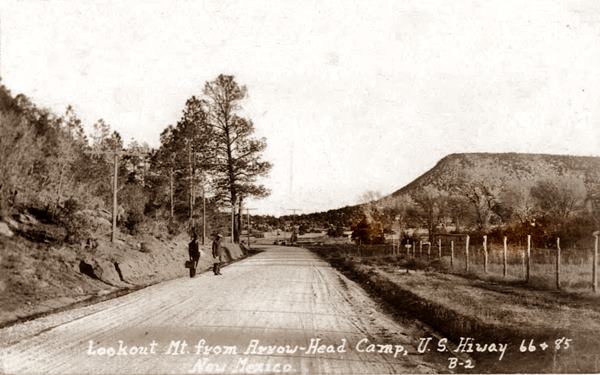
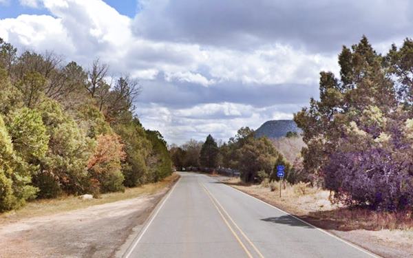
The image shows Lookout Mt. to the right, and notice that in those days the forest cover was less than it is nowadays, perhaps due to the logging industry in the area. Below is the same view nowadays.
Notice Lookout Mt. visible to the right.
The former campsite building before it was razed
Site of Arrowhead Pueblo Ruins
During a trip through New Mexico in 1933, Floyd V. Studer, from Amarillo, Texas stoped by chance at the Arrowhead Tourist Camp. Studer had taken part in archaeological work done by the Texas Technological College of Lubbock TX and knew that Dr. W. C. Holden the Director of of Archaeological Research at the College was keen on finding a site that could be excavated over a period of several years.
Talking with Mr. Slaughter, the camp's owner, Studer learned that there was a native ruin 200 yards south of his property. Slaughter agreed to give the College and Holden permission to dig on his property.
Holden excavated the site between 1933 and 1948 and dated it to AD 1370-1450. It has eight room blocks with at least 70 rooms and two kivas (large circular rooms used for religious ceremonies). The ruins sit on the summit of a low mesa facing Route 66. And we have marked the spot in our custom map with a red marker in our custom map, right next to a kiva.
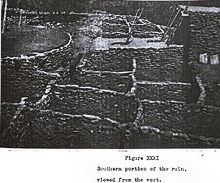
1937 view of Arrowhead Pueblo ruins. Source. Click to enlarge
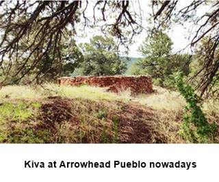
Kiva at Arrowhead Pueblo ruins. Source
Pigeon Ranch
Head west from Arrowhead Camp and ruins for 1⁄2 mile; yo your right, on the north side of the road is the old ranch.
The building is what remains of Old Pigeon's Ranch.Which was also a stage coach stop on the Santa Fe Trail. The adobe structure is a one story building with three rooms and a gabled roof. It is 48 feet long and almost 18 feet wide.
The Ranch was the property of Alexander Valle who was born in St. Louis ca. 1815 and although it is said that he was popularly known as "Pigeon" due to his pronounciation in "Pidgin English" with a strong French accent ("Government manns vas at my ranch and fill is cahnteen viz my viskey..."), it was actually his mother's second husband's name: "Pigeon of Carondelet".
By 1850 he was operating a frontier store in Santa Fe and obtained a grant confirmed by Congress in Glorieta (1865) where he lived until his death in 1880. He sold his ranch to George Herbert in 1865, in 1887 Walter Taber bought it, in 1925 a Glorieta cowboy, Thomas Greer acquired the place and seeing the flow of travellers along Route 66 converted it into a roadside attraction with a museum, curio shop, bears, garage, "Indian caves" and service station on the south side of the highway. When Route 66 was relocated to the south in 1937 (Santa Fe cut-off) business declined and World War II travel restrictions led to its demise.When U.S. 85 was realigned in the late 1940s along what now is known as Old Denver Hwy (W. Frontage Rd), it was abandoned.
In 1990 the property was added to the Glorieta National Historic Place and in 1992 the National Park Service acquired Pigeon's Ranch house.
Pigeon Ranch in 1925
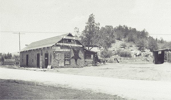
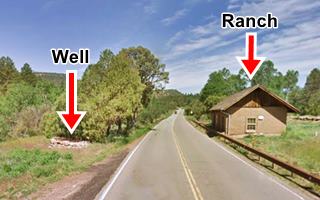
Notice the well in the foreground:
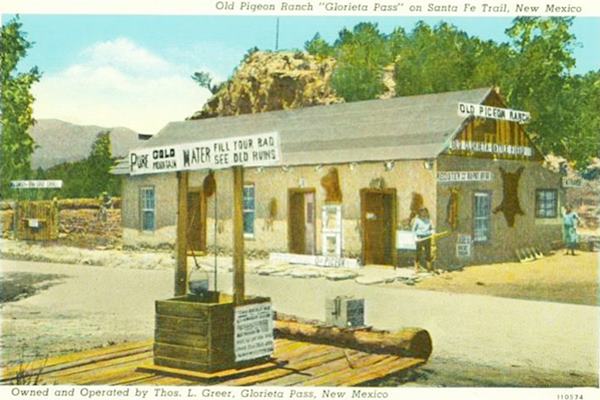
Water well
Greer claimed that a well located opposite the building on the south side of the highway was ancient. The sign read: "This old well was built about the time the Santa Fe Trail was opened up in 1822. Many of the oldtimers drank from this well whichw was quartered in old bldg." Later he remodeled it and the sign read "Old Indian Spanish American well over 250 yrs old." Actually it was built between 1851 and 1857 to provide clear drinking water for the ranch. The round stone well walls can still be seen beside the highway.
Current view of the old building
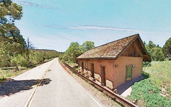
The Battle of Glorieta Pass
The westernmost battle of the American Civil War
Glorieta: Pecos National Historical Park & New Mexico Historic Marker
There is a historical marker on NM-50, 1 mi south of the village of Glorieta on the south side of the highway. See Map showing marker site, and the battleground is preserved by the National Park Service as part of the Pecos National Historic Park.
The battle of Glorieta Pass was fought from March 26 to 28, 1862 on this strategic pass accross the Southern Rockies between Glorieta and Santa Fe. Glorieta was the only point where the Rocky Mountains could be crossed south of Colorado, so it was the Confederate's bid to control the West. The historic Pigeon Ranch was a witness of the battle.
Confederate Brig. General Henry Sibley advanced with his men, "Sibley's Brigade" from San Antonio, Texas into New Mexico and occupied Albuquerque on March 2 and Santa Fe on March 10, 1862. Silbey decided to advance east and strike at Fort Union (now a National Monument, north of Las Vegas, NM).
Ft. Union was strategic and controlled the Santa Fe Trail. Two columns of Sibley's men advanced towards Glorieta Pass on their way to Ft. Union, one was comanded by Major Pyron and marched from Santa Fe, the other under Col. Scurry marched from Albuquerque.
They believed that the Union soldiers had been left behind at Ft. Craig (south of Albuquerque), but a column of Colorado troops under Colonel Slough had moved south to defend Fort Union, and were camped at Bernal Springs, east of Glorieta Pass.
Slough sent a column led by Maj. Chivington towards Santa Fe. They camped near Pecos and on March 26 reached Glorieta Pass, crossed to its western side, and met the Confederates in Apache Canyon and forced them to regroup in the "First Skirmish of Apache Canyon".
A second encounter took place later that day and the Confederates were routed. Their first defeat in New Mexico.
Pyron retreated and asked Scurry to send reinforcements. Chivington also requested assistance and moved back to Kozlowski's Ranch south of Pecos, on the Pecos River.
On March 27 each side had received its reinforcements and they stood on the east (1,340 Union soldiers) and west (1,000 Confederates) side of Glorieta Pass.
Both forces advanced towards the pass on the 28th and met in a battle that lasted six hours. The action took place around Pigeon Ranch.
The official casualty list was 96 Confederates and 71 Unionists, but the losses were actually greater. The Confederates won the battle but a second skirmish that took place on the western side of the pass during which a detachment of Union troops destroyed the Confederate supply train. Having lost food, ammunition and blankets, Scurry rapidly retreated to Santa Fe, and abandoned New Mexico, having lost two thirds of his men in his failed attempt to conquer New Mexico.
Westwards towards Santa Fe
Highest point on Route 66
At Glorieta the original roadway is overlaid by I-25 west of the village of Glorieta, obliterating its alignment. Take the freeway. It reaches the highest part of this segment, and then curves south at Glorieta Pass This was the highest point of the whole Route 66 from 1926 to 1937.
Highest Spots Along Route 66
There are several passes along Route 66 where it crosses mountain ranges, the highest spots are the following:
- 7,550 feet (2,301 m). Glorieta Pass NM, Sangre de Cristo Mountains. Highest point from 1926 to 1937. On the Santa Fe Loop.
- 7,405 feet (2,257 m). Bellemont to Parks, Arizona, crossing the San Francisco Mountains, 1931-41 alignment.
- 7,245 feet (2,208 m). Continental Divide, New Mexico, crossing the Rocky Mountains. 1927-85 alignment.
- 7,102 feet (2,166 m). Sedillo, NM on the 1937-45 alignment, replaced when it was realigned, by a spot at 7.057 feet (2,150 m). Comer's Cafe close to Sedillo on the 1945-85 alignment. Crossing the Sandia Mountains.
- 3,595 ft (1,096 m). Sitgreaves Pass near Oatman, California, crossing the Black Mountains. 1926-53 alignment.
After the pass, the higway descends along Apache Canyon on the western slope of the mountains. It was a narrow winding descent on the Santa Fe Trail but the railroad in the 1880s, and the construction of I-25 widened it.
Apache Canyon
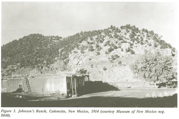
Governor Manuel Armijo fortified it during the Mexican American War in 1846 but he retreated to Santa Fe without engaging the U.S. troops. At the base of the slope, A. P. Johnson built a ranch in 1858. It was a trading post and also a stage station. It is located on the north side of the freeway (right) at a bridge by the base of the canyon at Exit 294.
During the Battle of Glorieta Pass in 1862, the Confederate army used it as their headquarters. Later Jhonson would complain that the looted his property, but he wasn't compensated by the Union for his pains.
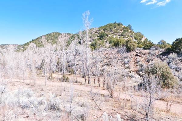
The ranc survived until 1967 when it was razed during the construction of I-25. Below is a "Then and Now" view of the ranch and the site:
Same spot nowadays
Our Lady of Light - Nuestra Señora de Luz Church
Listed in the National Register of Historic Places
Adjacent to the old Johnson's ranch site also on the north side of the highway at Exit 294 is the historic Nuestra Senora de Luz Church ("Our Lady of Light") and Cemetery. It was built in 1880 and is surrounded by a low stone wall. The graveyard is on its western side.
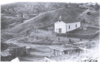
1914 view, Our Lady of Light, Canyoncito. Source. Click to enlarge
itemprop="name">Historic Nuestra Señora de Luz Church, Santa Fe
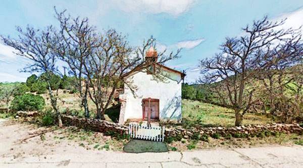
The church is now enclosed on its southern side by the freeway.
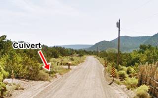
Culvert on 1926-33 US66, Canyoncito. St. view
Canyoncito
This area where the church is located is known as Canoncito, Cañoncito or Canyoncito, Spanish for "Tiny Canyon".
The original 1926-37 US 66 highway's alignment splits from the freeway here and heads west along the course shown with a violet line in our interactive map. Part of this alignment is gone, or a dirt trail, but there are some surviving concrete culverts along it (see violet markers on map).
End of this leg of your Road Trip
This marks the end of this leg of your journey. Continue your road trip by heading west to your next stop on your road trip: Santa Fe.
Sponsored Content

>> Book your Hotel in Albuquerque

Credits
Banner image: Hackberry General Store, Hackberry, California by Perla Eichenblat


