Route 66 in Bernalillo NM
Index to this page
About Bernalillo, New Mexico
Facts, Trivia and useful information
Elevation: 5,052 ft (1,540 m). Population: 10,614 (2004).
Time zone: Mountain (MST): UTC minus 7 hours. Summer (DST) MDT (UTC-6).
Bernalillo is the county seat of Sandoval County, and it was located on the alignment of Route 66 from 1926 to 1937.
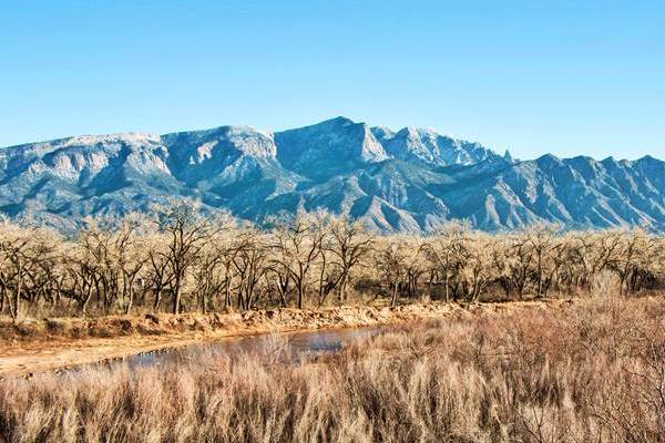
View of trees and Sandia Mountains from Kuaua Ruins, Bernalillo
History
The Valley of the Rio Grande and Jeméz Rivers has been inhabited for over 10,000 years. The Native American people have farmed in the fertile topsoil since 1200 AD. They built their pueblos of Santa Ana, Sandia and Kuaua along the river valleys and used the water to irrigate their crops.
Francisco Vásquez de Coronado, a Spanish conquistador, was the first European to explore the area in 1540. He named it the province of Tiguex and wintered at Kuaua Pueblo in what is now Bernalillo; see Coronado Historic Site and Kuaua Ruins further down.
In 1598 Juan de Oñate settled the region and reported several Pueblo villages along the native trade route that bordered the Rio Grande River. But the population had dwindled. The Spanish settled on the eastern side of the Rio Grande.
Origin of the name Bernalillo
The Spanish settled here after Oñate's expedition of 1598. One member of his expedition was Juan Griego who was accompanied by his wife Pascuala Bernal. It was common in those days for the children to adopt the maternal surname instead of their father's, and one of his sons did so.
The place where his descendants the González - Bernal family settled was known as "Bernalillo", a familiar diminutive (Little Bernal) maybe referring to the younger or "smaller" member of the family.
They lived there before the 1680 Pueblo Revolt and were the owners of a Royal Grant, "Real de Bernalillo".
The Spanish "Camino Real" (or Royal Highway) followed the Rio Grande on its eastern bank and linked the area with Santa Fe in the north and Mexico City in the south. A great rebellion (Pueblo Revolt) took place in 1680 and the natives expelled the opressive Spanish conquerors. But freedom would be short lived. The Spaniards returned in force in 1692, they subdued the rebels, and resettled the area.
The González - Bernal resettled again in their hacienda (ranch). Giving it its name (1695) The district to the north of the town was known as "La Angostura de Bernalillo", meaning "the Bernalillo Narrows", a place where the Rio Grande could be crossed easily. It became a stopping place along the Camino Real, and was smaller than neighboring Algodones.
Camino Real
El Camino Real de Tierra Adentro National Historic Trail is a historic route used since prehispanic times. It is in the process of nominating properties associated with it to the National Register of Historic Places.
The original trails date back to prehistoric times when turqouise mined in the region was traded with the Mesoamerican civilizations such as the Toltecs and the Aztecs.
Priests, traders, government officials, convicts and prisoners of war moved up and down it. Livestock and Goods were moved along the trail in caravans consisting of dozens of wagons; they could carry 4,000 lb. (1,800 kg) of merchandise and were pulled by eight mules.
In 1821 Mexico won its independence from Spain and Nuevo Mexico passed on to the new country, but it was lost after Mexico's defeat in the Mexican - American War (1846-48). The territory was ceded to the United States. During this war, Bernalillo was described as follows: "...the prettiest village in the Territory... green meadows, good square houses, and a church, cotton-woods, vineyards, orchards...."
In those days Algodones the largest town in the region and a post office opened there in 1855, but it moved to Bernalillo in 1881.
In 1876, Bernalillo County with its seat in Albuquerque absorbed the old Santa Ana County that comprised the town Bernalillo. The Atchison, Topeka and Santa Fe Railroad reached the area in the 1880s and built a depot here. In 1903, nine years before New Mexico's statehood, Sandoval County was created from the northern part of Bernalillo County and Bernalillo became its seat.
In 1915 it was described as having 1,000 residents and gives a different version of the place name: "Bernalillo (bare-nah-leel'yo, locally ber-nah-lee'yo; Spanish for little Bernard) was so named because it was settled by descendants of Bernal Díaz del Castillo, who was associated with Cortez in the conquest of Mexico. The population consists mainly of Mexicans, and the village is one of the oldest settlements in the valley. The fertility of the wide valley and the favorable conditions for irrigating by use of the water of the Rio Grande have been the principal factors in sustaining a large settlement at this place. De Vargas, the Spanish governor who restored Spanish domination after a lapse of 12 years, died here in 1704. There have been Indian villages on the same site and in the vicinity for centuries."
Both Route 66 and U.S. Highwaty 85 were aligned through Bernalillo between Santa Fe and Albuquerque bringing tourists and prosperity. But it would not last for long, in 1937 the Mother Road was realigned along a shorter alignment between Santa Rosa and Albuquerque and this "Santa Fe Cut-off" bypassed Bernalillo. However, it was located at a good spot and tourists traveling along U.S. 85 stopped in Bernalillo to visit the Coronado Site and Jemez Pueblo.
Accommodation in Bernalillo
There is lodging along Route 66 in Bernalillo and nearby in Santa Fe and Albuquerque:
> > Book your Motel or Hotel nearby, in Santa Fe or Albuquerque
More Lodging close to Bernalillo on US 66
Below you will find a list of some of the towns along Route 66 in New Mexico. Click on any of the links to find your hotel, motel or accommodation in these towns (listed from east to west);
On Route 66's Main alignment
The Santa Fe Route 66 segment
Eastwards
Westwards
The weather in Bernalillo
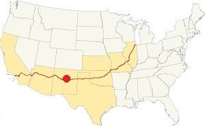
Location of Bernalillo on Route 66
The climate in Bernalillo is dry with plenty of sunny days (almost 280 per year), cold winters and hot summers. The relative humidity is low. Altitude and the dry air cause large the daily temperature swings of around 25°F (14°C).
The average High ⁄ Low Temperatures in summer (Jul.) are around 92 ⁄ and 65 °F (33 ⁄ 18 °C) respectively. The average in winter (Jan), are: 47 ⁄and 24 °F (8 ⁄ -4 °C)
Rain tends to fall during the summer monsoon season (July through September): about 11 in. per year (279 mm).
Up to 23 inches of snow may fall (58 cm) yearly, between October and March.
Tornado risk
The tornado risk in Algodones is nil, there are no tornado watches in Sandoval county.
Tornado Risk: read more about Tornado Risk along Route 66.
Map of Route 66 in Bernalillo, NM
Check out our interactive custom map showing Route 66's 1926-37 alignments in Bernalillo.
The original Route 66 was aligned through Bernalillo in 1926 along three previous highways, the "Ozark Trail", the "Santa Fe Trail" and the "National Old Trails".
These highways were known as "Auto Trails" and part of a public demand for "better roads": a movement that lobbied for good highways that could be used by motor vehicles, and also signs to mark them and help drivers to find their destination. New Mexico authorities improved the original Ozark Trail in 1914 and designated it as New Mexico State Highway 3. The thumbnail map (Click to see large size map), shows some of the "Auto Trails" that could be used by cars in 1912 in the area near Bernalillo (map's upper right side); the trails are marked with red lines.

1912 Road map, western NM
Click on image to enlarge.
Source

1925 Road map, western NM
Click on image to enlarge.
Source
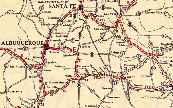
The second thumbnail map above from 1925 (click on it to see the full sized map) shows the roads that existed one year before Route 66 was created.
Those marked "22" (National Old Trails Rd., coming from Los Angeles) and "32" (New Santa Fe Rd.) with white letters in a black box, went from Gallup to Albuquerque and through Santa Fe. Highway "50" was the Ozark Trails.
The only paved sections (full black line) were between Albuquerque and Bernalillo, and Albuquerque and Tijeras. The highway from Bernalillo to Santa Fe, and beyond Isleta was "improved" (dashed line), the rest were either graded or dirt roads. Bernalillo on the upper right side of the map.
The Santa Fe Loop (1926 - 1937)
This was the first alignment of Route 66, from Santa Rosa to Albuquerque via Pecos and Santa Fe.
We describe this segment in our Santa Fe Loop page, a dedicated webpage, with the full alignment, from Santa Rosa, through Dillia, Pecos, Santa Fe, Algodones, and Bernalillo all the way to Albuquerque.
This original highway also continued beyond Albuquerque to Isleta, Peralta and Mesita.
Bernalillo is on the upper left side:
1937 Realignment of Route 66
A political dispute between New Mexico Governor A. T. Hannett and local politicians led to the realignment of Route 66 in 1937.
Hannett blamed the local party bosses when he lost his 1927 bid to re-election. He decided to punish them, and their backers (the business men in Santa Fe) so he quickly had state highway #6 built, in 1927, to link Moriarty with Albuquerque. This highway bypassed the capital city, and was 90 miles shorter for those driving from the east to Albuquerque.
In 1937, the Federal roadbuilders decided to realign Route 66 using Hannett's road, and paved it. It was a straighter highway, and only had a short mountain segment across the Sandia Mountains between Sedillo, Tijeras and Carnuel.
Route 66 Alignment near Bernalillo
With maps and full information of the alignments of Rte. 66.
- Albuquerque to Lupton (next)
- Santa Rosa to Albuquerque 1937-85 (parallel)
- Tucumcari to Santa Rosa (previous)
The Santa Fe Loop (1926 - 1937)
Our Santa Fe Loop page describes the complete 1926 to 1937 alignment of Route 66 from Santa Rosa to Albuquerque through Pecos, Santa Fe and Bernalillo.
Bernalillo: its Attractions
Route 66 sights and historic landmarks
Bernalillo is a small community with some interesting historic places. Drive westswards along the Camino Real (former US 66) from Algodones, the highway crosses fields and a semi-rural area. At U.S. 550, take a right to visit two cultural and historic landmarks.
Coronado Historic Site & Kuaua Ruins
Listed in theNational Register of Historic Places and a New Mexico State Monument
It is 1.6 mi. from old Route 66. Head west along US 550 cross the Rio Grande and visit the Historic Site located at 485 Kuaua Rd, Bernalillo, NM. (Map with directions).
A 14th century Native American Pueblo where the Spanish explorers from Mexico first encountered the Pueblo Indians in 1540.
Francisco Vásquez de Coronado was the first Spaniard to explore what is now New Mexico. He set forth with a company of 400 soldiers and 1,000 native auxiliaries, horses, cattle, sheep, and priests. His aim was to find gold, silver and other riches and convert the heathen to Christianity.
He reached this area on the Rio Grande and named the region Tiguex (he wrote it Tigüez) and called the natives "Pueblo", after the Spanish word for "village". He did not find gold, but wrote that the valley was farmland with plenty of corn, beans, melons, and cottonwood groves.
In August 1540 he reached the Tiwa Village of Kuaua (which in Tiwa language meant "Evergreen") which now is the Coronado Historic Site. It had been built in 1300 AD. It was a large Pueblo and the valley had about 20,000 residents at that time.
The village covered 6 acres and had 1,200 homes, six ceremonial kivas, and 3 plazas.
Coronado spent the following winter (1540-41) and had an armed conflict with the natives as he forcibly took their blankets from them. Then he headed west to explore the prairies, but he returned again to Tiguex in October 1541 to winter again. He wrote a letter to his king, Philip II:
I have tried to explore this land two hundred leagues and more around Cíbola, and the best that I have found is this river of Tigüez, where I am, and the population here does not allow us to settle them, because, we must be four hundred leagues [1,200 mi] from the north sea [Atlantic] and from the south sea [Pacific] two hundred [600 mi], where there is no way to keep the men warm, only hides with which the natives dress and some few cotton blankets..." Francisco Coronado, 1541
Once again, in the spring of 1542 he tried to head east again and seek better luck in Texas and Kansas, but his men were tired and he returned, empty handed to Mexico in April 1542.
The natives were left alone for over 50 years, but the Spanish returned in 1598, and imposed Catholic religion and a system known as "Encomienda" a mix of indented labor and serfdom. The opression and forced conversion led to war in 1680, the Pueblo Revolt. The natives abandoned the pueblo, and it remained abandoned, in a relatively untouched state, west of the main throughfare that ran along the eastern side of the Rio Grande.
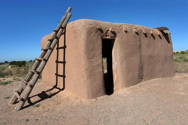
The site was exavated and reconstructed in the 1930s and a very interesting sight is the Kiva 3, or Painted Kiva, with its reproductions of the original painted murals in its reconstructed interiot. A kiva is a building with a cilindrical shape used for ceremonial purposes.
Visit the Spanish-Pueblo style visitor center and museum, walk the interpretative trail and get some great views of the pueblo and the Rio Grande and Sandia Mountains.
More information at the official website
Santa Ana Pueblo
It is 10 miles to the northwest, see this map with directions.
Their traditional name in Keresan dialect is "Tamya".
The original site of the pueblo is unknown because the natives fled or died during the 1680 Pueblo Revolt. Around 1693 they were resettled at the current locationon the Jemez river. But the site was a poor choice as there wasn't enough land for farming under irrigation, so the Santa Anas bought farmland on the Rio Grande in the mid 1700s and set up their homes there in Ranchos de Santa Ana, between Algodones and Bernalillo, the old original pueblo was relegated to its current role as a ceremonial site.
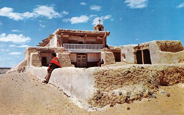
They are well known for their handicrafts, textiles and pottery. You can buy them at the Ta-Ma-Ya Cooperative Association.
Festivities
The Corn Dance is a must-see and takes place on the date of its patron Saint, Santa Ana (Saint Anne) which takes place on July 26. There are other ceremonial dances, one on June 24 (St. John) another on St. Peter's day (June 29).
You can head west on a Day Trip, the Jemez Mountain Trail described further down or head back to Bernalillo and head south to visit its other landmarks.
Important rules of etiquette during your visit to a Pueblo
Pueblos are on tribal lands and the local customs, religion and traditions must be respected.
- Check that access is allowed(leaders may restrict access for private ceremonies) and be prepared to pay an access fee
- Photography. Taking photos may be totally prohibited or a permit may be required. Check with the Tribal Office. Even if you have a permit, always request permission before taking a photo of a tribal member. Leave your cell phone out of sight and silence it, as it could be confiscated
- Don't litter. Don't carry or use alcohol or drugs
- "Off Limits" signs must be respected. Don't remove artifacts or pottery shards
- Don't speed. Respect traffic signs. Lock your car the Pueblo is not responsible for missing items
- Respect the local people. Dances are not a show, they are a ceremony. Show respect and remain silent at all ceremonies
- Cemeteries, Kivas, ceremonial rooms are sacred places and entry is not allowed for non-Pueblo people

Return to Bernalillo and Route 66 and turn left, southbound just 1⁄4 mi ahead, to your right is Bernalillo's church.
Our Lady of Sorrows Church
Santuario de San Lorenzo

Our Lady of Sorrows and Saint Lawrence Sanctuary. Source
301 S. Camino Del Pueblo, Bernalillo, NM.
Listed in theNational Register of Historic Places
The adobe church named Nuestra Señora de los Dolores (Our Lady of Sorrows) dates back to 1857; it was built in a French style with local materials including walls 4 feet thick, an earthen floor and timber beams. It broke away from the typical Spanish Mission style common in this area. It is famous for its Matachines dance in honor of Saint Lawrence. It was refurbished in 1892.
The church safeguards the image of San Lorenzo (St. Lawrence) and is therefore its "Sanctuary", the Santuario de San Lorenzo. The saint's feast is celebrated every year as it is the town's patron saint. The festivity includes a procession with the saint's image and the Matachines dance (Aug. 9 to 11).
Matachines Dance
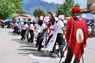
Matachines dancing. Source
It originally celebrated the victory of Christianity over the Moors in Spain (Dance of Moors and Christians) and was introduced by the missionaries in America to symbolize the victory over the heathen. The natives adopted it, using masks and dances which vary from village to village.
The 1680 Pueblo revolt took place on Saint Lawrence's day, Aug. 10, and that saved countless Spaniards who were out of their haciendas during the revolt as they were taking part in the festivity. After the reconquest, the new Governor Diego de Vargas (1693) reinstated the St. Lawrence celebrations to thank the Saint for his help in their fight
The Matachines Dance in Bernalillo is the largest and most complex in the Southwest, including a dancer dressed like a bull (El Toro) and a symbolic bullfight. Worth seeing!
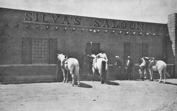
Silva's Saloon
One mile from the church, on the right side of the highway at 955 S Camino Del Pueblo.
Felix Silva Sr. opened the Bernalillo saloon back in 1933, one day after Prohibition ended. He had been involved in liquor for many years, since New Mexico enacted its own prohibition in 1917, before the Federal ban on alcohol of 1920. Moonshine corn liquor was his speciality. It has been run by the Silva family since then.
It claims to be "the oldest continuous business on Historic Route 66."
The building's front was cut by 17 feet when the highway was widened and paved.
Iceburg Cafe
Head west for 0.3 miles and the original alignment of US66 and 85 curves to the left. Here was the final location of the wacky Iceberg or Iceburg Cafe, that moved twice in Albuquerque and a third time to Bernalillo.

Iceberg Frozen Custard advertisement, 1931. Source
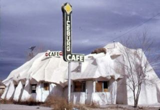
Iceburg Cafe, at its last location in Bernalillo. Source
The Iceberg began life on May 27, 1931 as a frozen custard stand, at 3017 Central Ave. in Albuquerque and was called "Mac's Iceberg". The prefabricated structure had one module and was shaped to look like an iceberg and was the creation of Kansas born Carl Armstrong "Mac" McAdams, although he went broke in 1932, it was bought by new owners and a second module added.

Iceberg Cafe (2nd location) c.1940s. Albuquerque Route 66. Source
Click to enlarge
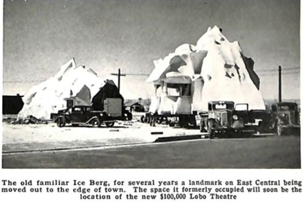
Being prefabricated (stucco over chicken wire with a timber frame) it was taken apart and moved in 1938 to 5219 Central Ave. as the second Iceberg Cafe, here it also included a filling station selling Cosden branded gas and signage with a polar bear.
Below is a photo of the 1938 moving of the building, the caption reads "The old familiar Ice Berg, for several years a landmark on East Central beingmoved out to the edge of town. The space it formerly occupied will soon be the location of the new $100,000 Lobo Theatre."
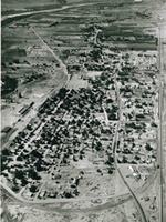
Aerial view of Bernalillo 1950s. Source
Click to enlarge
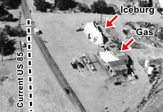
Iceburg 1950s. Source
In 1953 it moved to Bernalillo on "Hwy 85 18 miles north of Albuquerque" and renamed the Iceburg (with a "U"); the address was 1236 S Camino del Pueblo. It was eventually torn down in the 1960s-70s.
It can be seen on the lower right side of the thumbnail aerial view of Bernalillo in the 1950s, click image to enlarge it. This aerial view looks north, the railroad runs on the right side of the image, with US 85 winding across the town, that was much smaller than it is today. The church can be seen on the upper part of the image, Camino Don Tomas runs at an angle on the left, and the Rio Grande on the upper left side.
As you can see in the other image (enlarged from the aerial view), there was a gas station with two bays next to it, the modern alignment of U.S. 85 didn't exist (dashed line). Although the iceburg is gone, the filling station survived (St view.
Sandia Pueblo
Drive south along NM 313 (Old Route 66). See map with directions.
The Pueblo's name in Tiwa language is "Tuf Shur Tia," which means "Green Reed Place." Francisco Vasquez de Coronado visited it during his expedition in 1539. Juan de Oñate who occupied the area in 1598 called them "Napeya" (a deformation of their name Na-Fiat). Theirs was the largest pueblo in the Tiguex Province, and had been built in 1300 A.D. The Spanish settled there in 1617 and built the San Francisco Mission. It was razed during the uprising that expelled the Spaniards in 1680. When the territory was reconquered in 1692, the town was left in ruins despite repeated petitions for resettlement by the natives.
In 1762 the pueblo was rebuilt and the natives allowed back. They were to serve as a buffer against the raids of Navajos and Comanche.
Its current name "Sandia" was given by the Spaniards, and it means watermelon in Spanish. Visit its two local sights:
Bien Mur Indian Market
6 mi. south of the pueblo, 100 Bien Mur Dr NE, Albuquerque. (Map with directions). Visit the largest retail arts and crafts store in the Southwest; it is owned by the Pueblo of Sandia.
Sandia Buffalo Herd
A 107-acre preserve right. The western most part of the Buffalo preserve boundary is east of Bien Mur and borders the parking lot. Experience a real live American Bison while visiting the Pueblo.
End of this leg of your Road Trip
Sandia marks the end of this leg of your journey. Continue your road trip by heading west to your next stop on your road trip: Albuquerque; wich you will enter along the 4th St. Route 66 - 1926-37 alignment.
Crossroads of Route 66
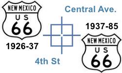
Fourth Street and Central is one of the few places along Route 66 where two alignments cross each other.
The original 1926-37 alignment ran along 4th Street across Albuquerque with a North to South course, from Santa Fe towards Isleta. And the later 1937-85 Route 66 was realigned along Central Ave, with an East to West course, from Santa Rosa through ABQ and onwards towards Laguna. U.S. 85 was also aligned along 4th.
Albuquerque is such a large city and has so many Route 66 landmarks, that we have dedicated six pages to describe them:
Index to our six pages on Albuquerque & Route 66
- Albuquerque (this page: an overview)
- Eastern Albuquerque
- Nob Hill
- Downtown
- Old Town & Western Albuquerque
- 4th St. Route 66 - 1926-37 Sights

Tours & Itineraries
Jemez Mountain Trail
This is a full day round trip with different variants
The route goes through the Jémez Mountains with cliffs, forests and a gushing river take you back to the past.
You will pass by Santa Ana Pueblo and visit San Ysidro, Jémez Pueblo, and Zia pueblo. You can continue north in a wide circle through Valles Caldera National Preserve, Fenton Lake State Park, Bandelier National Monument, Los Alamos, and finish in Santa Fe.
Zia Pueblo
The Zia Sun symbol appears on the New Mexico State flag. The ancient pueblo was occupied by the Spanish in 1583 and razed in 1689. It was rebuilt later. Visit it on the north side of the river (see Map with directions).
National and State Parks
There are many natural parks in the area, and we describe them with full details in our Albuquerque and Santa Fe pages. Just click the links below:
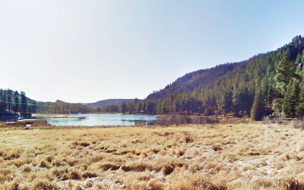
Lake Fenton State Park, near Albuquerque, NM
Sponsored Content

>> Book your Hotel in Albuquerque

Credits
Banner image: Hackberry General Store, Hackberry, California by Perla Eichenblat
Robert Julyan. 1996, The Place Names of New Mexico, UNM Press.


