Route 66 in Pecos NM
Index to this page
About Pecos, New Mexico
Facts, Trivia and useful information
Elevation: Elevation: 6,923 ft (2,110 m), Population: 1,376 (2025).
Time zone: Mountain (MST): UTC minus 7 hours. Summer (DST) MDT (UTC-6).
Pecos is town on the western tip of San Miguel County, New Mexico. It has grown recently due to commuters that live there and work in Santa Fe. The Pecos River runs along the northern and eastern sides of the town, from its sources in the Sangre de Cristo Mountains in the Santa Fe National Forest.
Pecos' History
This part of New Mexico has been inhabited for more than 10,000 years (the nearby site at Sandia Cave is proof of this). These hunter gatherers later evolved into the an agricultural society, the Pueblo people who settled in the valleys of the rivers that flowed south from the Sangre de Cristo and Rocky Mountains where they irrigated and farmed the fertile soil.
The area around Pecos was settled by these Native American farmers arond 700 AD and the ruins at the Pecos National Historic Park on Glorieta Creek survive to this day.
The area was an important trade center between the Pueblo people and the Indians from the plains to the east and Pecos and the pueblos close to it were the easternmost villages of this group. The Pecos River served as the "Old Pecos Trail".
The expedition led by Spanish "Conquistador" Francisco Vasquez de Coronado reached Pecos in 1540, they were the first Europeans to visit the region. Coronado named the native people "Pueblo", after the Spanish word for "village" these Spaniards described it as follows, using the native name Cicuye:
Cicuye, a very strong village ... of nearly five hundred warriors, who are feared throughout that country. It is square, situated on a rock, with a large court or yard in the middle, containing the estufas. The houses are all alike, four stories high. One can go over the top of the whole village without there being a street to hinder. There are corridors going all around it at the first two stories, by which one can go around the whole village. These are like outside balconies, and they are able to protect themselves under these. The houses do not have doors below, but they use ladders, which can be lifted up like a drawbridge, and so go up to the corridors which are on the inside of the village... The village is inclosed by a low wall of stone. There is a spring of water inside, which they are able to divert. The people of this village boast that no one has been able to conquer them and that they conquer whatever villages they wish. Pedro de Castañeda de Nájera (1540)
The name: Pecos
Castañeda called it Cicuye, which was the name that the Pueblo people of the Tiguex pueblo on the Rio Grande called the Pecos people. They spoke Tigua language; those living in Isleta who speak Tigua still call Pecos Sikuyé.
However, the Pecos people called themselves Pe-kúsh or pa-kyoo-la that meant "place where there is water," alluding to the spring inside the pueblo.
These words were deformed by the Spanish deformed into the name Pecos, for the pueblo and its inhabitants.
In 1598, Juan de Oñate occupied the region as a Spanish Colony, and the Mission Nuestra Señora de los Ángeles de Porciúncula de los Pecos was established at the Pecos Pueblo in 1619.
The Spanish used a system called "Encomienda" (charge ⁄ patronage) where the land and native inhabitants were granted to a settler as serfs. This exploitation of the natives led to their uprising, in the Pueblo Revolt (1680) and the expulsion of the Spaniards. They burned the churches, missions and ranches. However, the Spaniards returned in force in 1693 and forcibly subdued the Pueblo Indians. After resettling the area and rebuilding the mission church, they adopted a softer stance with the Pueblo people.
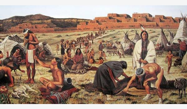
The settlement in this area was slow, and Pecos Pueblo gradually decayed, its people suffered from disease (Old World illnesses for which they had no defenses), and unhealthy living conditions like a cemetery close to their water source.
Raids by prairie indians contributed to the pueblo's downfall.
A formal land grant was approved in 1815, when the "Cañon de Pecos" was awarded to Juan de Dios Peña.
In 1821 it became part of the territory of an independent Republic of Mexico. The constant raids by the Apache and Comanche forced the last seven men, seven women and three children to leave the Pueblo. They moved to their sister tribe in Jémez pueblo across the Rio Grande, abandoning Pecos for good.
Mexico ceded New Mexico to the U.S after its defeat during the Mexican-American War (1846-48), and white settlers moved in, including Martin Koslowski who staked a claim here in 1858, building an inn and trading post at his ranch close to the former Pecos Pueblo and Mission.
During the American Civil War, the Confederate troops fought a battle with the Union forces near Pecos (1862) and camped at Koslowski's ranch.
The Atchison, Topeka and Santa Fe Railway built its tracks along the Santa Fe Trail in the early 1880s and established a station 4.5 mi. west of Rowe. It was named Decatur, then Fox, and finally Pecos.
A mine, the Terrero Mine, operated in the Canyon north of the town between 1882 and 1939. It was a source of income for the village.
In 1926, Route 66 was aligned through Pecos and several roads were built in the Pecos Canyon by the Civilian Conservation Corps during the 1930s. Dude ranches were established in the area to cater to the tourists: the Forked Lightning Ranch and Valley Ranch were two of them.
In 1937 US 66 was realigned further south, between Santa Rosa and Albuquerque, bypassing all the towns along the Santa Fe Loop including Pecos.

Accommodation near Pecos
There are plenty of lodging options for those traveling along Route 66
> > Book your room nearby in Santa Fe or Las Vegas NM
More Lodging Near Pecos along Route 66
Below you will find a list of some of the towns along Route 66 in New Mexico. Click on any of the links to find your hotel, motel or accommodation in these towns (listed from east to west):
On Route 66's Main alignment
The Santa Fe Route 66 segment
Eastwards
Westwards
>> There are RV campgrounds near Pecos in Santa Fe
The weather in Pecos
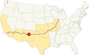
Location of Pecos on Route 66
Pecos has hot summers and cold winters, the area is quite arid and dry.
The average high in summer (July) is 86°F(30°C) and the average low is 53°F (11.7°C). During winter (Jan) the average high is 48°C (8.9°C) and the average low is 21°F (-6.1°C), below freezing point.
Snowfall is around 25 inches (63.5 in.) on average and can fall at any time between November and April. Most falling during Dec. and Jan (6 in. each). Rainfall is 17.2 in. per year (437 mm). The rainiest months are June through Sept. with almost 10 inches of rain.
Tornado risk
Pecos is located in an area with virtually no tornado risk: San Miguel county only has two (2) Tornado watches per year and mostly in the eastern fringe of the county.
Tornado Risk: read more about Tornado Risk along Route66.
Map of Route 66 in Pecos, NM
Visit our The Santa Fe Loop (1926-37) alignment page for a detailed description of Route 66 in this area. Below is the color coded interactive map:
>> Custom map of Route 66 in town
The red line in our custom map shows the alignment of US 66 across Pecos, the violet line is the Pecos-Glorieta-Santa Fe segment.
The original Route 66 was aligned through Santa Fe in 1926 along three previous highways, the "Ozark Trail", the "Santa Fe Trail" and the "National Old Trails".

1925 Road map, Central NM
Click on image to enlarge.
Source
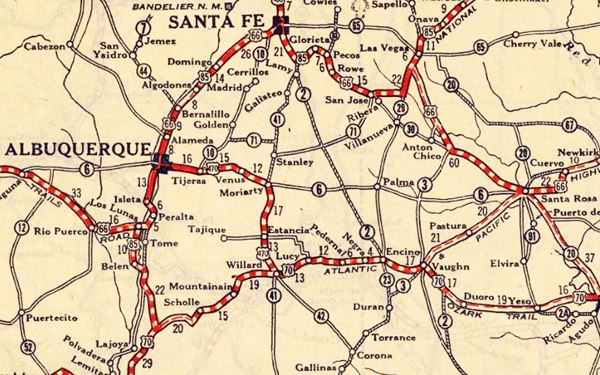
The thumbnail map from 1925 (click on it to see the full sized map) shows the roads that existed one year before Route 66 was created.
Notice "Pecos" on the center-right side of the map.
Those marked "22" (National Old Trails Rd., coming from Los Angeles) and "32" (New Santa Fe Rd.) with white letters in a black box, went from Gallup to Albuquerque and through Santa Fe.
The only paved sections (full black line) were between Albuquerque and Bernalillo, and Albuquerque and Tijeras. The highway from Bernalillo to Santa Fe, and beyond Isleta was "improved" (dashed line), the rest were either graded or dirt roads.
The Santa Fe Loop (1926-1937)
This was the first alignment of Route 66, from Santa Rosa to Albuquerque via Pecos to Santa Fe.
We describe this segment in our Santa Fe Loop page, a dedicated webpage, with the full alignment, from Santa Rosa, through Dillia, Pecos, Santa Fe, Santo Domingo, and Bernalillo all the way to Albuquerque.
This original highway also continued beyond Albuquerque to Isleta, Peralta and Mesita.
See Pecos (middle-top) in this map
1937 Realignment of Route 66
A political dispute between New Mexico Governor A. T. Hannett and local politicians led to the realignment of Route 66 in 1937.
Hannett blamed the local party bosses when he lost his 1927 bid to re-election. He decided to punish them, and their backers (the business men in Santa Fe) so he quickly had state highway #6 built, in 1927, to link Moriarty with Albuquerque. This highway bypassed the capital city, and was 90 miles shorter for those driving from the east to Albuquerque.
In 1937, the Federal roadbuilders decided to realign Route 66 using Hannett's road, and paved it. It was a straighter highway, and only had a short mountain segment across the Sandia Mountains between Sedillo, Tijeras and Carnuel.
Route 66 Alignment near Pecos
With maps and full information of the alignments of Rte. 66.
- Albuquerque to Lupton (next)
- Santa Rosa to Albuquerque 1937-85 (parallel)
- Tucumcari to Santa Rosa (previous)
The Santa Fe Loop (1926-1937)
Our Santa Fe Loop page describes the complete 1926 to 1937 alignment of Route 66 from Santa Rosa to Albuquerque through Pecos, Santa Fe and Bernalillo.
Pecos: its Attractions
Landmarks, Route 66 sights
Drive north from Rowe along highway 63. At Glorieta Creek, is Kozlowski's Ranch, described in our Rowe page, established in 1858 by a Polish immigrant, Martin Kozlowski, it was an inn, trading post and stagecoach stop on the Santa Fe Trail.
The Historic Santa Fe Trail
The Spanish settlers in Santa Fe opened the "Santa Fe Trail" in 1792 to link their city with the French trading posts in Louisiana, on the Missouri River.
Much later in the 1820s wagon trains used it to move merchandise to and from New Mexico. After 1848 it became one of the main trails used by the settlers to reach the Southwest and the coast of the Pacific Ocean.
The southern fork of the Trail passed through Las Vegas, Rowe, and the pueblo of Pecos, crossed Glorieta Pass to reach Santa Fe.
Pecos Pueblo
Head north for 0.6 miles along NM-63, to your left is the entrance to the Pecos National Historical Park.
Pecos National Historical Park
NM-63, Pecos, NM.
Listed in theNational Register of Historic Places & U.S. National Historic Landmark
The park preserves the ruins of Pecos Pueblo (or Ciquique) and the remains of the Mission Nuestra Señora de los Ángeles de Porciúncula de los Pecos.
Created as the Pecos National Monument in 1965, it was later re-designated as the Pecos National Historical Park. Besides conserving the Pueblo and the Mission, the Park has two other units (located nearby), one preserving the Glorieta Pass Battlefield, site of an American Civil War battle; the other unit is the Forked Lightning Ranch.
Pecos Pueblo-Cicuye Pueblo
National Historic Landmark
There is a self-guided trail (1.25 mi. long - 2 km) which you can take through the Pueblo and also, visit the remains of the massive adobe walled mission.
The pueblo of Cicuique (or Cicuye) is located on a rock outcrop that faces the Pecos River; the Glorieta Creek runs along its western flank and was the main route across the Mountains towards the Rio Grande and Santa Fe region.
The pueblo was inhabited for five centuries between 1,300 and 1838 AD, and during the Colonial period, it was the easternmost of the Spanish Pueblos.
The Spaniards reached Pecos Pueblo in 1540 when Hernando de Alvarado visited "Cicuique" (Cicuye); as mentioned further up he reported that the town had four-storied buildings. At that time its population was 2,000. They were farmers who grew corn, squash, and beans irrigating their fields. They maintained a relative truce with the natives of the Great Plains, and their fortified pueblo deterred any attacks.
The Spanish returned in 1591 under Gaspar Castaño de Sosa and confronted with a hostile reception, he attacked the pueblo, subduing it. In 1599 the Governor Oñate renamed it Santiago and assigned a missionary to convert the natives to the Catholic religion. This was the origin of the "Mission."
Mission Nuestra Señora de los Ángeles de Porciúncula de los Pecos

Ruins of Pecos Pueblo,Pecos Mission Church in the background
A church was first established at the Pecos Pueblo in 1619, on a ridge abouth 1⁄4 of a mile to the northeast of the village. It was part of the Mission of our Lady of the Angels of Porciuncula; this long name comes from a small chapel in the municipality of Assisi in Italy. A second building replaced it in 1625, built beside the village but it was destroyed during the uprising of the Pueblo people in the 1680, the "Pueblo Revolt."
During the revolt, the natives built a traditional kiva (ceremonial room) in front of the church.
After the Spanish returned in force in 1693, they reasserted their power over the natives and in 1717 erected a third church on top of the former building's ruins.
The remains of the church display thick adobe walls and a fortress-like structure enclosing the atrium.
The rain washed the adobe over the next two centuries; Kozlowski, and also the residents of other ranches in the area took timber and beams from the church and used it on their own properties. The church has gradually decayed.
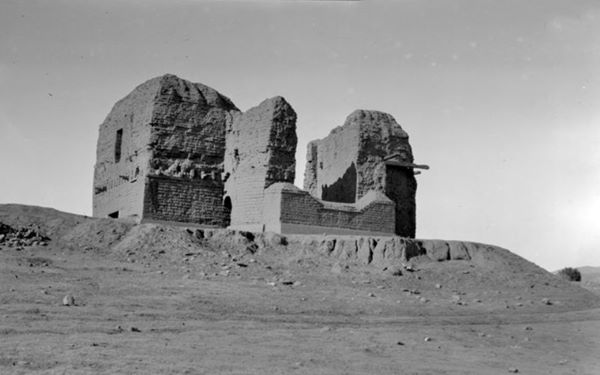
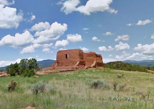
The last seventeen residents left the pueblo for good in 1838 and moved to Jémez pueblo.
Forked Lightning Ranch
This ranch forms part of the Pecos National Historical Park and is the central section of the 13,000-acre ranch that belonged to movie star Greer Garson and her husband Buddy Fogelson.
The ranch has a long history: after Martin Koslowski's son Thomas lost his father's land in 1925 due to non-payment of owed taxes. The U.S. government repossessed the land and granted it to Tex Austin, a rodeo entrepreneur who renamed it "Forked Lightning Ranch" adding mmore land from the old Pecos Pueblo Grant. He included the old building of Kozlowski's Stage Stop and Tavern, which had served travellers along the Santa Fe Trail (1858-1880). He added a trading post and commissioned architect John Gaw Meem to design and build the main ranch house next to the Pecos River.
Route 66 brought tourists to the area so Tex converted his property into a Dude Ranch.
DudeRanch
A "Guest Ranch" or "Dude Ranch" is a ranch that caters to visitors and tourists, giving them a taste of the "Old Wild West" and the life on ranches.
But the Great Depression ruined the business and it closed in 1933, Tex went broke and sold the ranch to W.C. Currie in 1936. In 1941 it was acquired by E.E. Buddy Fogleson, a rich Texas oil man who married actress Greer Garson in 1949. They expanded the ranch from its original 5,599 acres to its current size.
After Buddy's death, his wife sold it to The Conservation Fund in 1991. The Fund donated it to the National Park Service.
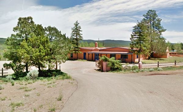
Pecos, the modern town
The town is aligned along NM highway 63 which has a north-south direction. Head north after the junction with NM-50 into the old part of town.
Saint Anthony Church
Listed in the National Register of Historic Places
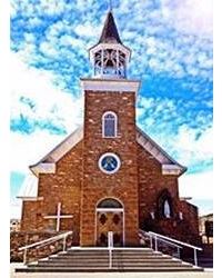
St. Anthony Church, Pecos NM. Source.
Click for St. view
After the mission at the pueblo decayed, the local residents at Pecos village needed a church. At first the parish at San Miguel covered their needs, but when the population grew to over 350 residents in 1860, the diocese in Santa Fe established a parish in Pecos. The original church was built in 1862 and burned around the turn of the century. The locals rebuilt it (1903-06) using locally quarried stone instead of traditional adobe. Among its adornments is the painting of Nuestra Señora de Los Angeles (Our Lady of the Angels) painted ca.1700 by Juan Correa in Mexico City, that adorned the original pueblo's church. It was given to the parish by the Pueblo people when they left Pecos Pueblo in 1838. This catholic church is still active today, the church is located at 11 St. Anthony’s Loop. Notice its cemetery beside the church.
Cross the Bridge over the Pecos River, and after 0.5 mi, on the left is the Monastery:
Our Lady of Guadalupe Abbey & Monastery
Just 1.5 mi. north of town (Map with Directions).
The site of the monastery was initially a Dude Ranch, the "Valley Ranch". When business turned sour, it was sold and became a Trappist monastery in 1948. It changed hands again becoming a Benedctine monastery (until 1985). Today it is still an Olivetan Benedictine monastery, used for group and individual retreats and spiritual guidance.
Below is a then and now view one hundred years apart; 1921 photo from the Santa Fe Railroad Brochure "New Mexico & Arizona Off The Beaten Path."
Click image for current St. view
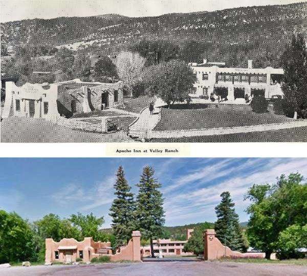
Turn back to the crossroads of NM-50 and NM-63, head east for half a mile, on the southeastern side of the Pecos river bridge is a cabins complex that dates back to the Route 66 days.
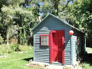
Cabin by the river in Pecos NM. Source
Pecos Cabins
The original cabins catered to Route 66 and 85 travelers from the 1920s onwards. There still are cabins along the river in this spot along the eastern bank of the river on River Cabin Rd.
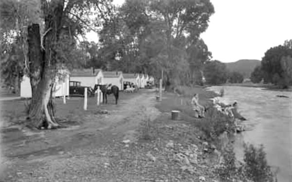
There were other buildings in Pecos, like Gross, Kelly & Co. who had many trading posts and stores in the region, and Pecos Motor with a Red Crown filling station and garage.

1920s Pecos Motor Co gas station. Source. Click to enlarge
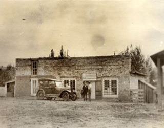
1918 Gross, Kelly & Co. store Pecos. Source. Click to enlarge
End of this leg of your Road Trip
This marks the end of this leg of your journey. Continue your road trip by heading west to your next stop on your road trip: Glorieta.

National and State Parks
Above we mention the Pecos National Historical Park which also has outdoor activities.
Villanueva State Park
The park is 34 mi. south of Pecos, via San Jose, Map from Pecos to the park
It includes sandstone mesas and the Pecos River canyon. There are places to picnic or camp and hiking trails. There is an RV park too.
More information at the Park's website.
Santa Fe National Forest-Pecos Wilderness Area
The Santa Fe National Forest was created in 1915 to protect almost 1.6 million acres of land (6.307 km2) in nothern New Mexico. It spans the Jemez mountains and the Sangre de Cristo Mountains, with several districts (Cuba, La Española, Coyote, Jemez, Las Vegas and Pecos.
The Pecos District manages the Pecos wilderness area with 223,000 acres. Ideal for hiking, fishing and camping.
Sponsored Content


>> Book your Hotel in Albuquerque

Credits
Banner image: Hackberry General Store, Hackberry, California by Perla Eichenblat

