More Sights in Tucumcari Page 2
Sights and Attractions in Tucumcari (Part 2)
- Western Tucumcari - read on below
- Downtown Tucumcari
- Sights in Eastern Tucumcari (Page 1)
- Tours & Itineraries
- Parks and outdoors
Tour of the Western Side of Town
We will start off at Route 66 and First Street, and head west along Route 66 (W. Tucumcari Blvd.)
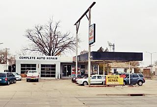
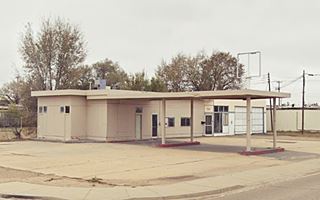
Jene's Texaco Gas Station
As you cross Main Street, East Route 66 becomes West Route 66. On the NW corner at 123 E Route 66 is a former Texaco station.
Jene's Texaco from 1962s has a flat canopy, two gas pump islands and a double bay garage. It is pictured below. Its advertising announced "Minor Repairs, Road Service, Pick Up & Delivery".
It closed in 2008. The steel poles held the TEXACO sign with horizontal block letters. Keep west along Route 66.
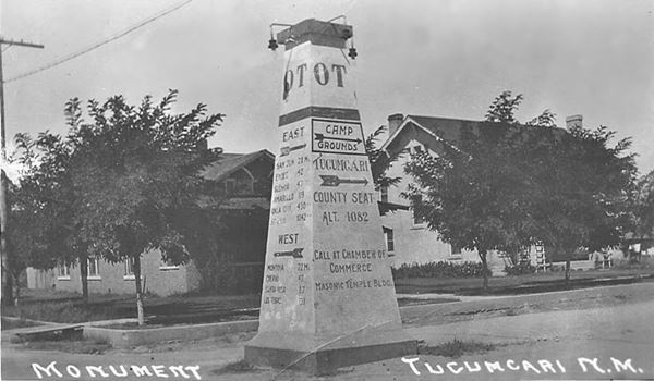
Ozark Trails Marker site
The Ozark Trails or "OT" for short was the work of a "better roads" movement embodied by the Ozark Trails Association, created in 1913. It sought to build good highways that could be used by motor vehicles, and to mark them. It served as the basis for later state and US highways (including Route 66). Tht OT passed through Tucumcari, and one of its markers, an obelisk-like monument stood on the NW corner of "Second and Garnell" (Garnell is modern Route 66). Below is a picture of the monument that was later removed, read the news article published on 27 Jun 1918 in The Tucumcari News and Tucumcari Times when it was erected.
Legendary Road Mural
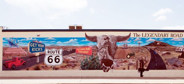
On the next corner, at S Second St., turn right and drive half a block to see one of Tucumcari's murals painted on the eastern wall of Lowes Market. There are more of them in the Downtown Tucumcari district located along 2nd St., to the north.
This mural is titled "Legendary Road", and is the work of Doug Quarles, who has also painted many of the other ones too.
Waterfield Chevron
Visit Downtown or turn around, take a right along Route 66 an on the next block on the SW corner of Third and W Route 66 is the old Waterfield Chevron-Standard Oil station. Its advertisement offered "2 Expert Mechanics on Duty Atls Tires, Batteries
& Accessories Standard Oil Products Excellent Service Third & Garnell Sts."
It has a unique angled service bay on its eastern side (and a mural). The three garage bays to the west are
in a detached building (they appear in the old advertisement).

1970s advert Waterfield Chevron. Source
Lins Cafe
At the other tip of the block, on the SE corner of W 66 and S 4th St is "Lins CAfe". Their postcard tells us "Complete Dining Service. Breakfast - Luncheon - dinners. Specializing in Skillet Fried Chicken - Also boxed to go. Reasonable Family Prices - 30 years in same location. Helen and Tom Lins - Owners and Operators". In another postcard we learned that at the "Rear of Cafe... See The Mammoth Petrified Trees... 60 and 80 feet long. Cactus Gardens... Indian Curios Old Buffalo Rifles." The building is still standing and the sign was modified.

1960s photo Lins Cafe. Source
Edsell's Shell station
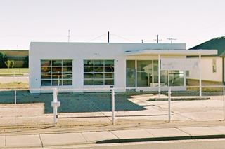
Across Route 66, facing Lins Cafe, on the NE corner of W 66 and 4th St. (227 W Tucumcari Blvd) is an old Shell station, "Edsell's Service". Its canopy has been enclosed, the steel poles of the sign stand on the corner, and it has three service bays.
Hitching Post
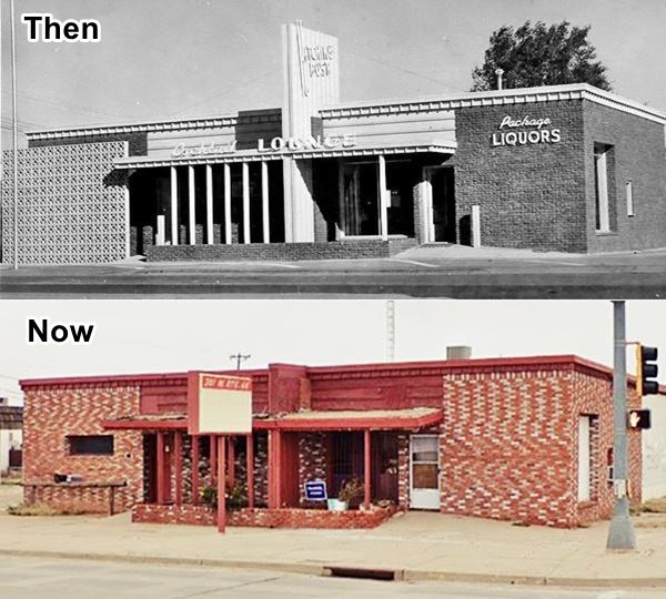
Facing it, across 4th Street, at 301 W 66 is a former cafe, bar and lounge. The original Hitching Post was located in the same building as Tommy's Steak Shop.
The building is still standing and in good shape but lost its hollow brick wall on the west side of the property and the vertical structure in the middle has been shortened.
Phillips Gull Wing - Adcock's

Old Adcock advertisement, Source
Across Route 66, on the SW corner, at 302 W Tucumcar Blvd. is Adckock Sixty Six station.
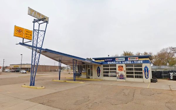
The Phillips 66 gas station pictured below was built in the 1960s. In those days Phillips Petroleum Co. standardized their filling stations across the US and adopted a modern design with a triangular "gull-wing" canopy which was supported at its narrow tip by a pole designed to look like an oil derrick. A Phillips 66 revolving sign stood at the top of the pole.
The former station has survived in very good shape, currently it is a lube and tire shop.
The glass garage doors and office are in perfect conditions, as are the canopy and pylon.
> > Learn more about Phillips 66 Gull Wing stations on Route 66
Whiting Bros. Recreated from Massey's Malco Station
On the SW tip of the block, following the Phillips 66 station is the former Massey's Malco Gas station (392 W Tucumcari Blvd.). Malco was a New Mexican oil company and brand that opened in the 1930s and was acquired by Atlantic in the 1950s. This station has been restored and made into a Whiting Brothers filling station.
So this restored gas station was never a Whiting Brothers station. It was recreated in Nov. 2011 by a group of local town volunteers. The mural, artwork and lettering were also painted by a local, Doug Quarles.
Below is a sequence showing it Before and After its restoration or recreation as a WB station.

Whiting Before restoration.
> > Learn more about Whiting Bros. stations on Route 66
Mark Huff Motor Company & The Malt Shop
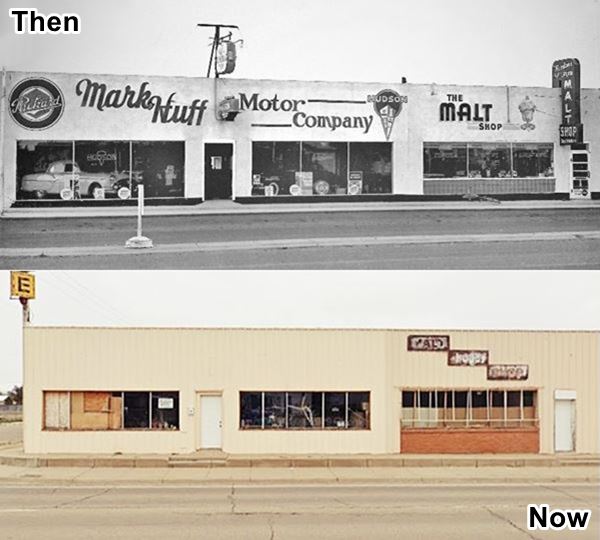
Facing the old Malco station, on the NE corner, following Hitching Post, was Huff Motor Co. and the Malt Shop. The photo below compares a black and white photo from July 1953 with its current appearance.
Lillie Stein Huf moved to Tucumcari in 1936. She was a registered nurse and had worked in the original Tucumcari General Hospital. With her husband Mark, she owned and ran both businesses, the Mark Huff Motor Company and the Original Malt Shop. It opened in 1940 on Center St. but moved to Route 66. They began as a Packard and Huidson dealership and closed when these brands were discontinued. The Malt Shop remained opened into the 1970s.

Johnson's Shamrock
Across the street, on the NW corner(401 W Route 66) was "Johnson's Shamrock Service" in a 1971 advertisement. It is a typical 1970 gas station with a separate canopy, two service bays and a plate glass office. It was an oblong box style that was upgraded in the '70s.
Graham Chevron
On the next block, to your left, on the SW corner of S 6th and W Rte. 66 (502 W 66) is M.D. Graham Chevron Service. The two island flat canopy station is still standing, repurposed.

Old Graham Chevron advertisement, Source
Travelers Motor Inn (Rafter "S" motel)
Ahead to your left is the Travelers Motor Inn (802 W Route 66 Blvd) it used to be the Rafter "S" motel in the late 1960s, it is marked with the red arrow in the image below (Blue arrow marks the Golden W motel).
In branding terminology, an inverted "V" or open triangle was a "rafter", and it enclosed an "S" hence its name. Across the street, to your right is a "classic landmark."

Rafter "S" Motel in 1970, Source
Pow Wow Restaurant and Lounge and the Congress Inn
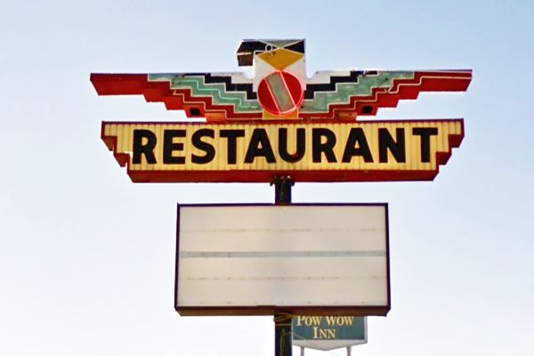
At 801 W Tucumcari Blvd. The Pow Wow Restaurant and Lounge and the Congress Inn (later Pow-Wow Inn) have survived. The restaurant is still open, now as the Lizard Restaurant, serving dishes! Don't miss its neon sign with a Native American Thunderbird.
The motel had "75 rooms, Color Television, Free Golfing Privileges, Heated Pool, Airport Courtesy Car... Owner Operated." Below is a "Then and Now" sequence. The red arrow marks the stone wall that has survived the reforms in the restaurant building.
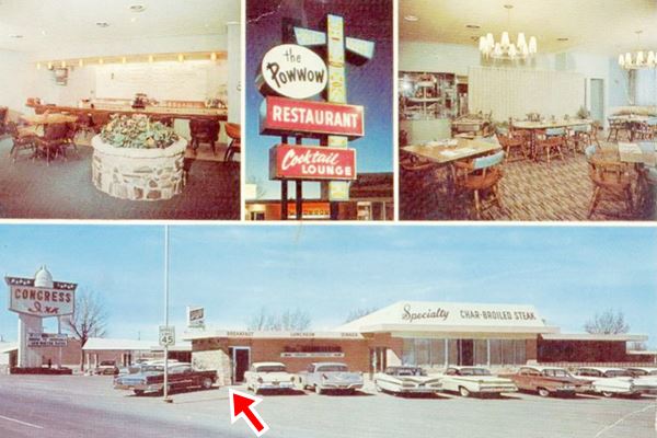
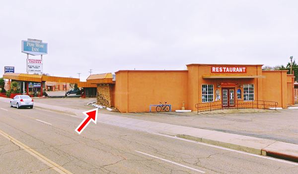
Ahead, after the former Rafter "S", on the south side of Route 66 was the Golden W motel.
Golden W motel
824 W Tucumcari Blvd. The old Golden W motel is still operating as a motel, though now its name is "Budget Inn". Its postcard says "Fourty-five comfortable rooms: phones, T.V.... Individual Heat, Heated Pool, Playground... Owned and managed by Belva & Katie Miller." It has lost its 60's neon sign and the roof over the reception area has changed slightly, but the place is basically the same. Even the "Pancake House" on the western side of the property is still there (St. view).
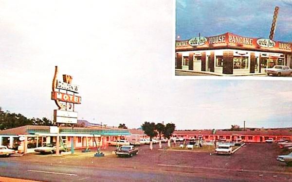
Next door was Baum Motors owned by Frank Baum, followed by Carlos Shamrock station; in the early 70s it became a Mobil- Balch Mobil Service and was later torn down. Below is a view looking east along Route 66 from the Mobil station, you can make out Baum's, the Pancake House and Golden W motel.


Detail showing the Enco, Shell and Texaco stations, Source
Three Restored Vintage Gas Stations
Ahead are three 1950s gas stations that have been restored and are in very good conditions.
They were on the eastbound lanes, and were used by those arriving at Tucumcari from the west. They were a former Texaco, an old Shell now restored as a Magnolia, and an Enco-Humble.
The image from the 1970s shows all three stations, looking east along Route 66.
The first restored station is Jim's Texaco, we describe it below.
Jim's #2 a Restored Texaco Station
Ahead, to your left, at 942 W 66, is a lonely gas station, a former Texaco, owned by Jim, who also owned what is now the Polly Gas Station (Jim's Texaco #1) on the eastern side of town. It has been restored and the steel posts that held up its sign are still standing (same sign displayed in the black and white photo further up).
Westerner Drive In. Gone
Facing Jim's Texaco it a decaying Westerner Drive In. The once bustling spot opened in 1949. It closed for good around 2000 and was slowly decaying, and has been torn down.
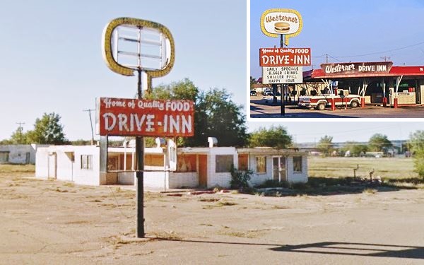
Old Lounge and Gas station
The next block has several landmarks, we will cover those on the south side (left) first. On the SE corner (W 66 and S 11th St.) stood an old building that once was "El Patio lounge" (click for St. view of the restaurant while it was still there), now torn down.
Next to it is a
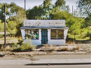
small building which appears to be an Ancient Gas Station, its pump islands are visible in the grass, but it has no service bays (see image) and no indication of the branding. There was another identical structure facing it, on
the north side of US 66 -now razed- you can see its St. view, at 1005 W Rte. 66. It too had empty concrete pump islands.
Then comes one of the classic sights of Tucumcari, the "Magnolia Station".
Restored Magnolia gas station
At 1016 W Route 66. This service station was actually a Shell! It was Gene's Shell Service Station. It never sold Magnolia branded gasoline.
Like the two restored gas stations on the eastern part of town (Polly Gas Station that was a Texaco, and the Phillips 66 that was an Enco), this one has also been rebranded during its restoration efforts.
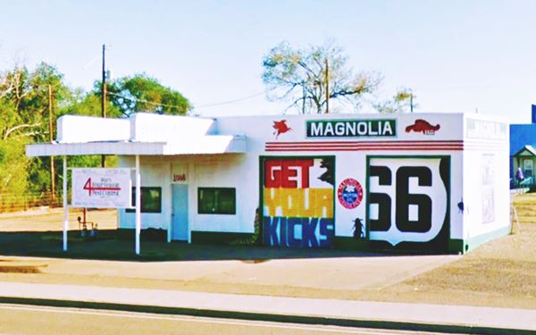
Magnolia Petroleum Company was founded in 1911 and Standard Oil Co. absorbed it in 1925. Finally, in 1959 it was part of their Mobil division.
The design of the station is interesting as the canopy, with horizontal roof extensions above it (crests), and rounded corners was typical of Texaco stations from 1930 to 1960. So maybe this station was a Texaco before it became a Shell. Anyhow, even though it wasn't a Magnolia staiton, it looks very nice and neat as you can see below.
Restored Enco gas station
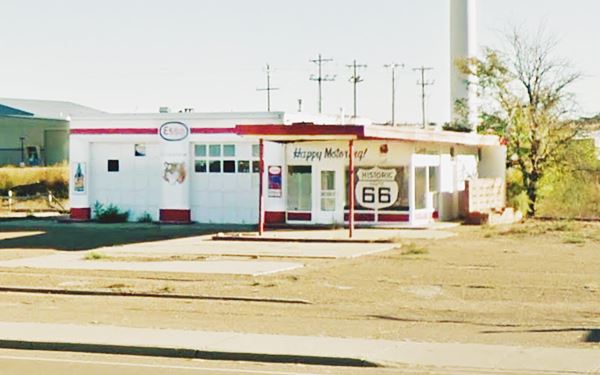
Just ahead, passing the Magnolia station, also to your left is another restored gas station, this one maintained the correct brand. It used to be Rigdon's Enco Service, at 1124 W.
Notice the "Happy Motoring" slogan on the office. The tall sign post with Enco in bold red letters is gone, but the steel poles are still there. You can see it in the old black and white photo further up.
The gas station is pictured below, with its single pump island, flat canopy and double bay garage. Kenneth Schlientz opened it. He was the Humble-Enco-Esso distributor for the Tucumcari area.
We will now head to the north side of Route 66 on the block facing the restored gas stations. After the now gone Westerner Drive-In, and old gas station is a classic Café.
Ranch House Cafe
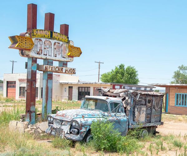
In the postcard below, they proclaimed "Good Food Always- Always Good Food". The now closed Ranch House Café opened in 1952. Pearl and Dugan Barnett ran it. The old building with a curious triangular shaped column on its facade is still there as you can see in the "Then and Now" sequence below.

Ranch House Cafe 1950s postcard. Source
The rusty, fading neon sign with an old jalopy is worth a photo; it reads "Ranch House Cafe Mexican Food".
Frontier station
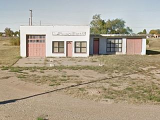
Next to the old Café at At 1023 W Rte 66 is a former gas station, now a home. It was a Frontier Gasoline station. The "Rarin'-to-Go" slogan with a red, white and black sign with a cowboy mounted ona bucking bronco can be seen in the image.
It incorporated in 1941 as the Frontier Refining Company and did business in Wyoming, Colorado, Utah, Idaho, New Mexico, Kansas, Nebraska, South Dakota, and Montana. It had a refinery in Cheyenne Wyoming and almost 400 retail outlets.
This particular station,
by the 1970s had become the "Bell Self Service Sta. 192".

Frontier Station c.1960s, Source

Old postcard of the Buckaroo Motel. Source
Buckaroo Motel
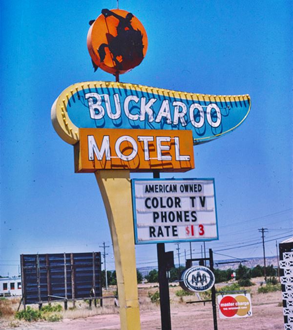
Just ahead, also on your right is a iconic motel at 1315 Rte 66. The Buckaroo Motel (buckaroo means "cowboy") is still open and catering to Route 66 travelers.
It was operated by the Jordans, and offered "nicely finished rooms. Excellent beds. tilet tub and shower. Panelray heat and airconditioning. Rollaways, Cribs and T.V."
It is relatively unchanged, it even has a nicer neon sign than it had during the Route 66 heyday.
Tristar Inn Xpress
Across Route 66, at 1302 W Rte 66 Blvd. is the current "Tristar Inn Xpress", which used to be the Tucumcari Ramada Inn. The postcard below from 1961, tells us it had "61 Beautiful, Lare Rooms; all rooms with Long Boy Beds; Heated pool... Free Teletype Reservation Service". As you can see in the images, it hasn't changed that much in sixty years!

Ramada Tucumcari Inn 1961 postcard. Source
Ahead as you approach the junction with US 54, to your right, on the "Y" fork, you can make out the remains of the foundations and pump islands of McAda's Gulf Service Station (St. view). To your left is the famous Route 66 Monument and a historic marker.
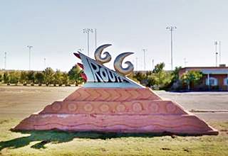
Route 66 Monument
On the south side, at 1500 W Route 66, this is a chrome and rock sculpture created by Thomas Coffin in 1997. The red stone of the base symbolizes tires while the chrome upper part is a tailfin with tail lights that light up at night. It evokes the 1950s cars and road trips. It is located in front of the Tucumcari Convention Center. The plaque reads: "Commissioned for the "Art in Public Places Program" New Mexico Arts of the Office of Cultural Affairs through the Cultural Corridors Project".
Historic Marker
The marker is next to it (St. view) and has the same text as the "Comanche Country marker" on the eastern side of town ("Comanche Country. By 1700 the Comanches had acquired horses and began moving into this area. They drove out the Jicarilla Apaches, and their raids on New Mexico's eastern frontier posed a threat to Indian, Spanish, and Anglo settlements for over a century. They were finally defeated by the U.S. Army in 1874.")
Redwood Lodge Motel
At the junction with US 53, Route 66 adopts a NE-SW course, and as it curves, to your left is another motel (1502 W Route 66)
The old motel had 28 units, and is now an apartment complex rented out to students "The Redwood Lodge". Its postcard says it was operated by George Gaintner and his wife. The old sign has gone, but the motel is still there, behind the trees.

Postcard, Redwood Lodge Motel Source
Tucumcari Trading Post

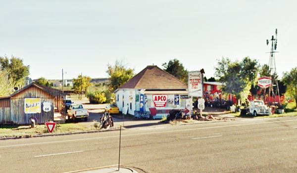
A "bare" Tucumcari Trading Post in 2020, Source.
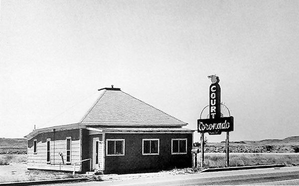
This now closed trading post started out as the Coronado Court around 1930. The office, which is still standing was built in a Western Bungalow style, popular in the early 1900s, a one story, square, hipped roof building.
The twelve rooms and garages were located on the eastern side of the property, in a long bunkhouse that is still there. It was in its time the first motel on the western side of town.
After it closed ca. 1970, Thelma Ruth bought it and opened an antique shop. It was later ran by her daughter Sharon and husband Gary Cardwell.
Now it has lost the decorations that were its main feature as you can see in the images below, but it still has its signage up.
A photo of the old Coronado Motel c. 1930s
Below is the former Coronado Court after it became the Tucumcari Trading Post, notice the vintage signs and antiques. The motel building is on the left side. Now the signs have been taken down.
Paradise Motel
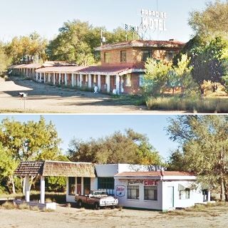
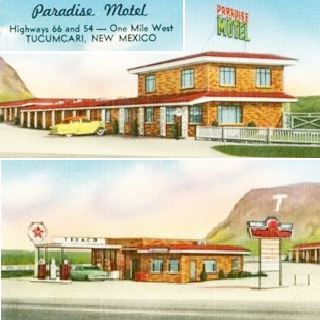
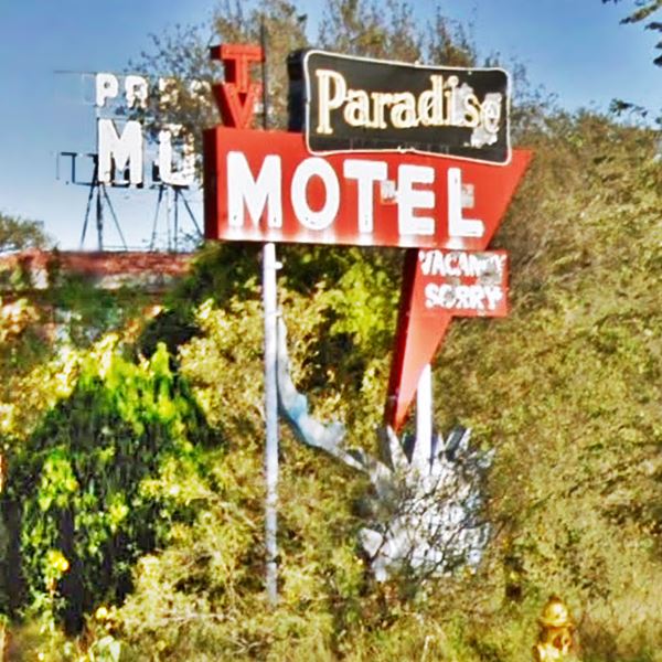
Continue west, and ahead is the former Paradise Motel and the old Texaco station.
At 2202 W Route 66, the motel with a two story office and a linear lay out, on the sout side of the property, with a cafe and former Texaco gas station (despite the Sinclair logo that now decorates the building).
Don't miss the old neon sign (pictured at the top of the page), facing west to lure in the visitors that entered Tucumcari. This was the first, and last motel in town.
This marks your end of your Route 66 tour through Tucumcari.
Below we share some side trips and a short detour into Downtown Tucumcari.
Downtown Tucumcari
Drive northwards along 1st Street from Route 66 to visit the downtown district of Tucumcari. There are some interesting murals, a historic theater and some classic buildings.
Landmarks in the city center
Odeon Theater
Listed in the National Register of Historic Places.
123 South Second St. A genuine pre-World War II motion picture theatre with Art Deco details. The Odeon Theater was built during 1935-36 and opened on May 16, 1936. The auditorium seats 270 viewers and the top floor balcony 90; and remain unchanged, conveying a strong impression of how
movie theaters were in the 1940s.
The Greek word "odeon" means "theater" and was chosen because it was short and cheapened the costs of the neon sign.
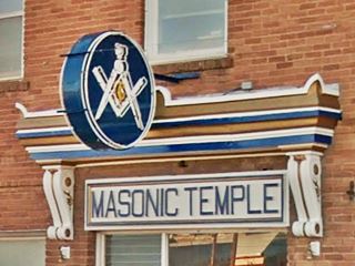
Masonic Temple
Across the street from the Odeon, at 201 S 2nd St. Great neon sign with the square, compass and the "G" for "Geometry", plus the inscription "Masonic Temple" above the doorway.
Vorenberg Hotel
Head north, and at 2nd and Main, to your right is what remains of the Vorengberg hotel mentioned by Rittenhouse. It burned down in the 1970s, and all that remains are the arches of the first floor windows. See the pictures "then and now" below, it dubbed itself as "A home away from home". The Spanish style hotel was owned by Adolph Vorenberg, and it opened in 1910.

1920s Vorenberg Hotel. Source
Rock Island-Southern Pacific Train Depot
N 2nd St. and W Railroad Ave. It was built in 1926 in a Spanish Mission style. Restored in 2001. It is a long depot for freight plus the passenger area. It served the Rock Island Railway and Southern Pacific Railway. Open to the public.
See its St. view .
Mesalands Dinosaur Museum
222 E Laughlin St. It has exhibits with the full range of prehistoric creatures: from saber-tooth cats to giant crocodiles and T-Rex-like dinosaurs. Visit the Museum's website.
US Highway 54 oldies
A drive west along Main St. (US 54) will lead you to many old 1950s gas stations, motels, and a creamery.
You can see their St. views by clicking on these links, we list them west to east:
Barnes Texaco

Bermuda Motel
Your city tour of Tucumcari ends here.
Tours & Itineraries
Some Side Trips from Tucumcari
Petrified Forest
It is located 6 miles southwest of Tucumcari and 1 mile south of Route 66. Unfortunately most of the fragments of logs and petrified wood that lie strewn on the ground, have been taken by tourists as souvenirs.
Five Mile Park or Metropolitan Park
Located 5 miles west of town (hence its name), it was designed by Trent Thomas during the Great Depression to employ local labor. It was completed in 1940 and had New Mexico's largest outdoor swimming pool.
It is part of New Mexico Heritage Preservation Alliance's list of Most Endangered for 2003. A fire destroyed the main building in 2010.
La Frontera del Llano
The meaning of the Spanish phrase "La Frontera del Llano" is "The prairies' frontier", it is a ride north of the town of Logan along NM 39 all the way to Abbot, it has a lenght of 94 miles (one way). See the Map and Directions.
The road takes you through plains, mesas and crosses rivers; it it the grasslands where the "deer and antelope roam".
National and State Parks
Las Conchas Lake State Park
Conchas means shells in Spanish. The park is 32 miles northwest of Tucumcari along NM 104 (Map with directions).
Contact: Park Website.
Ideal place for boating, fishing and swimming. Hiking and wildlife watching near the lake too. There are campsites and parking for RVs
Ute Lake State Park
27 miles northeast of Tucumcari via US-54 to Logan, NM and then NM-540 to the lake. (Map with directions). Contact: 1800 540 Loop Logan, NM, Park Website.
The reservoir on the Canadian River is 13 miles long and offers many options for water sports: fishing, boating, swimming. There are campgrounds and RV facilities too.
More Tucumcari Attractions on the Previous Page
In the Previous Page we describe Eastern Tucumcari's Route 66 attractions, weather, maps and an overview of the city's history.
Sponsored Content

>> Book your Hotel in Albuquerque

Credits
Banner image: Hackberry General Store, Hackberry, Arizona by Perla Eichenblat


