The length of U.S. Highway 66
Table of Contents
Index to this page:
- The World and Route 66, length comparison
- Route 66 Length: why did it change over the years?
- Route 66 mileage is reduced
- How long is Route 66 in each state it crosses?
The World and Route 66, length comparison
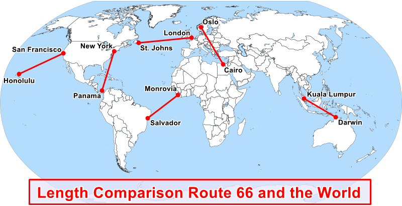
It is hard to grasp how far 2,400 miles actually is. To visualize this distance -more or less the length of Route 66, we took some well known landmarks, measured the distance between them and displayed them on the map below:
The following map shows where Route 66 is, marking its alignment, including the "Santa Fe Loop" through Santa Fe in New Mexico.
Map comparing the length of Route 66 and the distance between some Global Cities

Table of distances - including Route 66's length:
- 2,396 miles. San Francisco to Honolulu (US)
- 2,360 miles. London (UK) to St. Johns (Canada)
- 2,299 miles. Salvador (Brazil) to Monrovia (Liberia)
- 2,275 miles. Oslo (Norway) to Cairo (Egypt)
- 2,272 miles. Darwin (Australia) to Kuala Lumpur (Malaysia)
- 2,210 miles. New York (US) to Panama City (Panama)
- 2,238 miles. Route 66 length in 1960
- 2,448 miles. Route 66 length in 1926
That really puts it in perspective, doesn't it? Route 66 was originally longer than the transatlantic distance between London and Terranova! or across the Pacific Ocean all the way from Frisco to the beaches of Hawaii!
Route 66 was long, but not the longest highway in America
Despite its length, Route 66 wasn't the longest U.S. Highway, that distinction befell US 20 which is 3,365 miles long, linking Boston, Massachusetts with Newport, Oregon.
Route 66 lives on
Route 66 may not be the longest US highway, but it is the most famous one. A symbol of freedom, American way of life and joyful road trip vacations.
Route 66 Length: why did it change over the years?
The first US66 alignment was longer
Route 66 was created in 1926 by incorporating pre-existing state highways that in turn had been designated along older trails and roads. In the eastern states, these roads were mostly part of the Ozark Trail system, and in the west, the National Old Trails.
The Ozark Trail had been formed as a private organization in 1915 to improve the county and state highways, until then virtually non-existent.
The Trail was a collection of dirt or gravel surfaced roads which followed the section line roads.
Section Line Roads
Surveyors mapping towns and counties used grids consisting of one-square-mile sections.
Roads called "Section Line Roads" followed these lines and were used by farmers to reach their land.
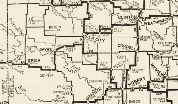
The "Auto Trails" map below, printed two years before Route 66 was created in 1926, shows Highway #3, or "Postal Highway" running along two alternate alignments from Foss to Canute, and then straight into Elk City. Route 66 was aligned along these earlier highways, notice the sharp 90° turns.

The Ozark Trail therefore had a 90° -right angle- turn every mile.
This made for a longer road (driving two sides of a square instead of its diagonal is 42% longer), slower driving speeds (due to the sharp turns) and more risk of accidents -at those corners (read about dangers of Route 66) .
However, building new roads was costly (earthworks involve grading, cut-and-fill, drainage ditches, etc.) so when the states began maintaining and upgrading highways in the early 1920s, they simply improved these zig-zagging section line roads.
An example is shown in the map below, which depicts Route 66 between Miami and Narcissa in Oklahoma, known as the Ribbon Road. The original US 66 1926 alignment followed Oklahoma State Highway 7, which in turn had followed the Ozark Trail (shown in orange). OK Hwy. 7 had been paved between 1918 and 1921.
Route 66 distance is shortened
The road was too narrow and its sharp turns made it unsafe. It was too long -lenght means more cost when repaving a highway. So highway engineers improved it:
Work on a new highway alignment began in 1935 it would link Afton and Miami.It had gentler curves (the Ribbon-Road has six 90° curves) and wider shoulders. It was opened in 1937 and is still used as U.S. 60 - 59, it is shown below in pale blue.
Map showing Route 66 alignment as the Ribbon Road section

See it in our interactive map.
Route 66 mileage is reduced
Similar "straighthening out" actions took place across the whole of Route 66; below we mention some of them:
- Springfield to Staunton, Illinois (1930 realignment). Map of this segment.
- Calumet to Bridgeport, Oklahoma (1932 realignment). Map of this segment
- Santa Fe Loop, New Mexico (1937 realignment). Map of this segment
- Albuquerque, to Isleta and Suwanee, New Mexico (1937 realignment). Map of this segment
Also unsafe curves were eliminated (Towanda's Dead Man Curve in Illinois).
Grade crossings or "S" shaped approaches to underpasses were removed (Bushland's deadly underpass, TX).
In the 1940s "Beltlines" bypassed many towns, routing the traffic around congested cities (Lincoln, Il and St. Louis Mo just to mention two).
In 1953, the alignment through Oatman to Topock, Arizona was realigned through Yucca, a flat and level option compared to the winding mountain road it replaced; see Kingman to Topock. Map of this segment
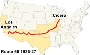
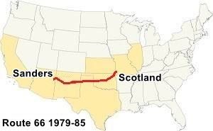
Finally the highway was shortened when its western and eastern termini were moved eastwards and westwards respectively starting in 1964. Read more about Where does Route 66 start and end. See the first and last complete alignments below:
1926-1927
East: Cicero, IL
West: Los Angeles, CA

US 66 Cicero IL to Los Angeles CA (1926 to 1927)
1979-1985
East: Scotland, MO
West: Sanders, AZ

US 66 Scotland MO to Sanders AZ (1979 to 1985)
Over the years the highway got shorter.
How long is Route 66 in each state it crosses?
The Route 66 Economic Impact Study, Vol 1. by David Listokin et al. (2011), gives the following figures citing Bischoff, Matt (2005). Life in the Past Lane: The Route 66 Experience:
2,448 mi. Original length and 2,238 miles the 1960 length. Just before its decertification began in California.
It also provides the following Route 66 length in each state:
- 289 mi. Illinois
- 313 mi. Missouri
- 13 mi. Kansas
- 376 mi. Oklahoma
- 189 mi. Texas
- 392 mi. New Mexico
- 388 mi. Arizona
- 318 mi. California
- 2,278 miles Total length
Sponsored Content

>> Book your Hotel in Hollywood

Credits and Further Reading
Banner image: Hackberry General Store, Hackberry, AZ by Perla Eichenblat

