Route 66 in Sunset Hills, Mo
Index to this page
- About Sunset Hills
- Sunset Hills's Weather
- Hotels and accommodation
- Map of US 66
- What to see and do in Sunset Hills
About Sunset Hills Missouri
Facts, Trivia and useful information
Elevation: 617 ft (188 m). Population 9,121 (2024).
Time zone: Central (CST): UTC minus 6 hours. Summer (DST) CDT (UTC-5).
Sunset Hills is a city located on the 1932-1977 Route 66 in St. Louis County, central-eastern Missouri.
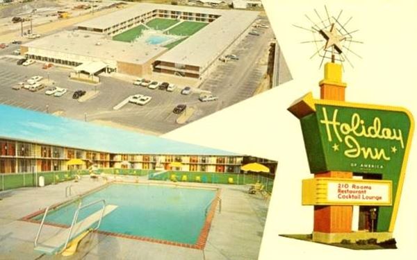
1960s postcard of the Holiday Inn South motel in Sunset Hills, Missouri - now it is the Days Inn
History of Sunset Hills
Eastern Missouri has been inhabited since the last Ice Age, and in more recent times, Native Americans built conical earth mounds in the region (in neighboring Fenton ca. AD 1050 - 1400). The Europeans who reached the area from Canada in the 1680s, encountered an Algonquin nation that called themselves "Illiniwek" which meant "men" in their language; they were hunter-gatherers who also grew crops of beans,corn and squash.
The French named the Indians "Illinois" and the region was called "Louisiana", after the king of France, Louis XIV. St.Louis was founded by Laclede and Chouteau in 1764 and settlers reached the area of Sunset Hills in the 1770s. France sold Louisiana to the U.S. in 1803; St.Louis incorporated as a municipality in 1809 and, three years later the Territory of Missouri was created. The State of Missouri joined the Union in 1821.
Sunset Hills was a rural area with sparse population living in farms and orchards. The main road, Watson Road was named after Wesley Watson who owned sand and gravel pit used in construction. Route 66 was aligned along it in 1932.
World War II veterans bought their dream houses in suburbia and soon Crestwood grew and became a city in 1949. Sunset Hills also grew, but slower as its farms were subdivided and developed. The neighborhood incorporated as a city in 1957 to avoid being annexed by neighboring Kirkwood.
The Name: Sunset Hills
The rolling hills of the area and its lovely sunsets prompted Mr. Vincent Gilliam to incorporate as "The City of Sunset Hills", motion which was approved.

Hotels and Motels: Sunset Hills, Missouri
You can find accommodation and hotels in Sunset Hills:
> > Book your accommodation in town:
St. Louis or Kirkwood
More Lodging near Sunset Hills along Route 66
There are several hotels in the area close to this town. Alternatively you can also find your accommodation along Route 66 in the neighboring towns and cities in Missouri. We list them below (from east to west):
On Route 66's Main alignment in MO
Eastwards
Westwards
- Hotels in Kansas
- Baxter Springs KS
- Galena KS
- Riverton KS
- Hotels in Oklahoma
- Miami OK
>> Check out the RV campground in neighboring Fenton
Weather in Sunset Hills
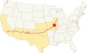
Location of Sunset Hills on U.S. Hwy. 66
Sunset Hills has four well marked seasons. It is located in the area where humid continental climate shifts towards a humid subtropical climate, so summers are hot and humid while winters are cold. It gets cold Arctic air and hot damp tropical air from the Gulf of Mexico. Spring is wet and may have extreme weather (tornados, thunderstorms and even winter storms). Fall is sunny and less humid, with mild weather.
The average high in winter (Jan) is a cool 39.9°F (4.4°C) while the average low is a chilly 23.7°F (-4.6°C). The summer (Jul) average high is 89.1°F (31.7°C) and the average low is 71°F (21.7°C).
Rain is on average 41 in. (1.041 mm) with the rainiest months being May through July with over 4.1 in monthly (104 mm). Snow falls between Nov. and Apr., with a total snowfall of 17.8 in. (45 cm).
Tornado risk
Tornado of 2010
Sunset Hills was hit by an EF3 tornado on Dec. 31, 2010 (yes, during winter), it killed one person and struck a four block area around Lindbergh Blvd. The town is located in Missouri's "Tornado Alley" and St. Louis County is struck by some 7 tornados every year.
Tornado Risk: read more about Tornado Risk along U.S. 66.
Map of Route 66 in Sunset Hills Missouri
The original alignment of Route 66 ran further north, along Manchester Rd. through Kirkwood and Wildwood to Gray Summit. It was replaced in 1932 by a shorter and straighter alignment through Eureka, Fenton, and after crossing the Meramec River, Sunset Hills.
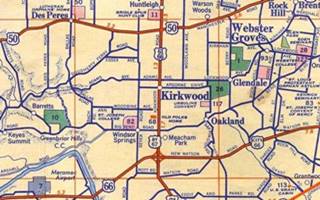
The thumbnail map below (click on it to see full size map) shows Bypass 66 running with bypass 67 and 61 from top to bottom through Kirkwood, and on the bottom of the map, Route 66 heading west (lower left) and into St. Louis as City 66 (lower right). They met at Sunset Hills
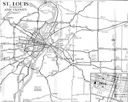
Above is another map, from 1955 showing all the roads leading into St. Louis; note US 66 and City 66 meet on middle left side of the map.
This is Map with Directions, of US 66 in Sunset Hills The part that can be driven ends at S. Geyer Rd. where you have to use the freeway (I-44) to cross the Meramec and head west into Fenton.
This is the Bypass 66 map in Sunset Hills. It comes from Kirkwood further north and meets the City 66 alignment at the Cloverleaf.
Rittenhouse and his 1946 Book: US 66 in St. Louis
Jack DeVere Rittenhouse in his "A Guide Book to Highway 66", published in 1946 gives us a first hand account: He drove through Edwardsville and Mitchell, and wrote that just past Mitchell, "Here City Route 66 forks off to the left into Saint Louis, while the main US 66 crosses railroad tracks and continues ahead to the CHAIN OF ROCKS BIRDGE and the "belt line" route skirting the city..." in his day the toll was for auto and occupants: 25¢ This was the best route if you were not planningon stopping in St. Louis. He describes its loop around the city, passing near the Airport and "rejoin[ing] City 66 at a point 26 miles from Chain of Rocks Bridge" the road was "a wide, high-speed route" lacking city traffic and with many service stations and some cabins and cafes.
He tells those who chose City 66 that, after the center of the city it ran along Gravois Ave. Chippewa St. and Watson Ave. meeting the Bypass 66 13 miles from St. Louis City Hall, this took place in Sunset Hills.
The map below, published in 1940 shows that the area at that time was mostly open fields, with few buildings.
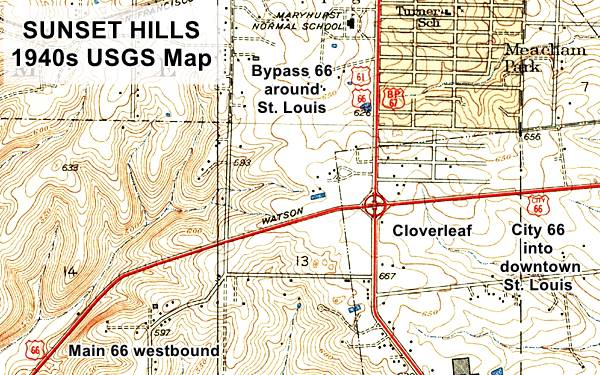
The Route 66 alignment in Sunset Hills
Visit our pages with old maps and plenty of information about US 66's alignments.
- Gray Summit to Rolla (next)
- Route 66 St. Louis to Gray Summit (In Sunset Hills)
- Route 66 Hamel IL to St. Louis MO (previous)
Route 66 Sights in Sunset Hills
Landmarks and Places to See
Historic context, the classic Route 66 in Sunset Hills
The WPA travel guide "Missouri, a guide to the "Show Me" state" published in 1941 does not mention Sunset Hills, but it does describe Sylvan Beach as "a privately operated amusement and recreational park on the Meramec River, with free picnic grounds, baseball diamonds, and parking facilities (swimming, riding and boating at nominal charge)." it adds that Father Gravier discovered the "River Miaramegoua" in 1700.
Jack DeVere Rittenhouse in his 1946 classic "A Guide Book to Highway 66" makes no reference to the town but does describe the "a 'cloverleaf' intersection on the west side of Saint Louis... 2 miles south of KIRKWOOD.... intersection of City 66 and Bypass 66" as being "about 13 miles from the City Hall in the center of St. Louis", followed two miles away by "SYLVAN BEACH, on the Meramec River, [which] is popular tourist resort."
Our Sunset Hills Route 66 Road Trip Tour
There are very few Route 66 landmarks or classic sights in Sunset Hills. Urban development, the construction of a new exchange at Lindbergh and Watson roads, the building of I-44 and I-270 and their exchange also removed old Route 66 buildings in the area, but you can still see remains of the former sights. This is the Map with directions of your 2.8 mile drive. Start your tour at Lindbergh and Watson, at the "Cloverleaf":
Site of the old Cloverleaf
Junction of Bypass 66 and City US 66
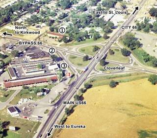
The image shows a view of the cloverleaf where Bypass 66 met City 66 and merged into Main US 66. The thumbnail image (click on it to see full size view) taken in 1960 looks east from the Meramec River towards St. Louis. See this Satellite view nowadays of this same spot... so many changes!!
We marked three now gone landmarks at the cloverleaf: (1) Westward Motel, (2) Nelson's Cafe and (3) Park Plaza Court (later the Ozark Plaza Motel).
What was a cloverleaf?
The concept was patented in 1916 by Arthur Hale, but the first one was designed by Edward Delano and built in 1928 in Woodbridge New Jersey at the intersection of Routes 25 and 4 (now US 1, 9 and State Hwy. 35).
The concept of wide loops that allow motorists to change direction at a busy intersection without stopping was the key to cloverleaf design. However it had its drawbacks:
the drivers merging onto a highway and those trying to leav it converge on a short stretch of road, causing jams, slowing the flow of vehicles and increasing the risk of accidents. The cloverleaf design is now
only used in rural settings with low volumes of traffic.
The cloverleaf at Sunset Hills was replaced by the current configuration in 1985.
See this aerial photo taken in 1958 of Sunset Hill's cloverleaf.
Cloverleaf at Byp 66 & City 66
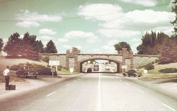
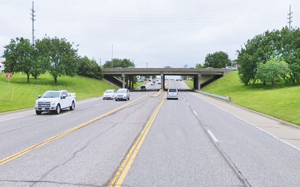
As mentioned by Rittenhouse above, here, at the junction of Watson and Lindbergh Blvd. both City and Bypass Route 66 alignments met. There was a bridge here, built in 1931, carrying Watson Road across Lindbergh Blvd. It was a arched concrete rigid-frame bridge and was part of the cloverleaf interchange that linked both highways, Bypass US 66 running along Lindbergh, and City US 66 which the following year ran along Watson. The old bridge was replaced in 1985 by a concrete girder bridge.
Below is a "Then and Now" sequence of Route 66's cloverleaf:
Same spot nowadays: notice the wider bridge on the overpass to accomodate the dual lanes on the highway beneath.
Looking north. US66 crosses the bridge, Bypass 66 begins ahead and runs north.
Some sites of Route 66 attractions at the Cloverleaf
They have all been torn down, but they are worthy of mention, this was a very busy junction in the golden days of Route 66:
On the NW corner of the intersection was the
Westward Motel (Gone)
On the northbound lanes of Lindbergh (BYP 66) it was built in 1953, now the La Quinta Inn & Suites by Wyndham St Louis Route 66 stands on the site. Below is a view of the old motel.

Westward Motel c.1960. Credits

Nelson's Cafe in c.1950. Credits
Nelson's Cafe (Gone)
On the northern corner of the complex that included the adjacent motel. Pictured above in the 1940s. Built in a Spanish Revival - Mediterranean style with curved parapets it was torn down in 1971 to make space for the Holiday Inn that now stands on the corner.
Park Plaza Court (Gone)
On the Southwest corner of the cloverleaf, over the years it expanded, included a pool in the main courtyard and had over one hundred rooms it later became the Ozark Plaza Motel.
Old Holiday Inn
Head south of the cloverleaf, and to your left at 3660 South Lindbergh Blvd. is the Holiday Inn "South". Its postcard proclaimed "Intersection 66, 61,50 and By-pass 67 & 50". The old hotel is still operating, but now it is the Days Inn.
This aerial photo taken in 1968 shows the building (Lindbergh runs from top to bottom on the left side of the image). It had a square layout around a central courtyard with a swimming pool.
We pictured it in a vintage postcard at the top of this page. Now all that remains is the building facing Lindbergh, which became a restaurant (Helen Fitzgerals's Irish Grill and Pub). The hotel was later a Days Inn and was torn down in 2020 (2019 view before it was razed).
Head west to visit a local landmark with no Route 66 significance, Laumeier Sculpture Park:
Laumeier Sculpture Park

"Time Fork2, by Van McElwee, Laumeier Park. Credits
At 12580 Rott Rd, St. it is an open air museum with outdoor sculptures in a 105-acre park. Visit their website for more information.
Now head north and then west to visit the north bank of the Meramec River, the site of the now gone Sylvan Beach:
Sylvan Beach
Route 66 - I-44 and Meramec River
The site along the eastern shore of the Meramec River was very suitable for a resort because the gravel at Sylvan Beach had no dangerous currents so it was ideal for swimming and bathing.
Route 66 passed along its southern side providing easy access.
The land was owned by Frank and Ethel Weimeyer, and Louis Peters leased it from them in 1932, on the brand new
Route 66 alignment and bridge across ther river.
The resort had picnic areas, a restaurant and a swimming pool. Peters and his partners went broke in 1935, hit by the Depression, so the Weimeyer's took over again.
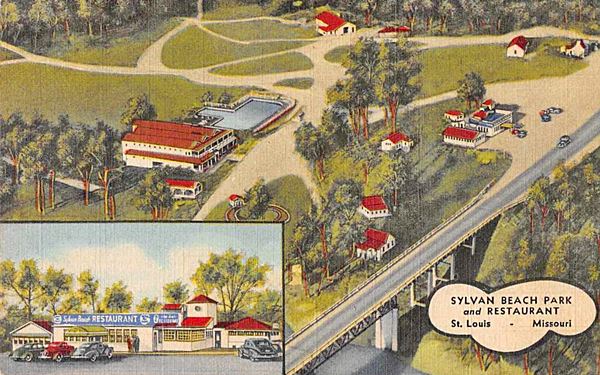
In 1936 they added a quarter-mile racetrack with midget racing cars.
The four-lane improvements done to Route 66 in 1954 included building a new set of bridges across the Meramec River and it is said that this cut into the land of Sylvan Beach but we disagree because the new bridges were built on the south side of the existing one. The restaurant was demolished at that time, but not due to the new freeway. Its sign survived and can still be seen at the Route 66 State Park Visitor Center.
The former resort is now part of the "Emmenegger Nature Park".
Emmenegger Nature Park
The park covers 93 acres and the adjacent Possum Woods Conservation Area has another 15 acres. It was part of the vast estate of the Lemp family, members of the wealthy elite of St. Louis. It was acquired by Russell Emmenegger in 1970 and donated to the City of Kirkwood.
Learn more at the park’s website.
Beer Barons of St. Louis
This area along the forested banks of the Meramec River was the setting for the mansions and summer homes of the wealthy "Beer Barons" of St. Louis.
The Anheuser, Busch, Griesedieck and Falstaff families made this spot their "Hamptons" in the Ozarks.
Many Germans migrated to America in the early 1800s and they brought their beer-brewing skills with them. Some of them grew from homemade beer to vast beer empires over the course of the nineteenth century and they provided beer not only to the German immmigrants living in St. Louis, but also to the whole nation.
Lemp Mansion is a good example of their summer homes. It was built in the 1880s and is still standing as a private home on Alswel Lane (map showing the location).
The former US 66 now crosses the Meramec River into Fenton; it was here that the first Route 66 Meramec River Bridge stood:
US 66 Meramec River Bridge in Sunset Hills

Route 66 map (1927). West of St. Louis Credits
Click on Map to Enlarge
We found an interesting map (click on it to see full size image) published in 1927 showing that at that time the Sunset Hills bridge hadn't yet been built. The curious fac is that Route 66 (marked with a Blue arrow) aligned alpong "Ozark Trail" on the map, runs from Pacific through Eureka and turning north to meet US 50 at Valley Park, crossing the Meramec River there! at the place where MO-140 is now located, it then merged with US 50 and headed east into St. Louis. US 50 (Red arrow) ran further north along what was the original 1926-32 Route 66 alignment.
The alignment of Route 66 that was built by 1932 is shown with the dashed red-yellow line from Valley Park, across the Meramec and all the way to St. Louis city limits.
The original bridge (a Lost Warren deck truss bridge) was built in 1932 by the Wisconsin Bridge & Steel Co. for the new Route 66 Alignment along New Watson Rd. It was a
two lane bridge that remained operational for many years. The USGS maps of the area give us an insight into its evolution: The 1940 map shows it as carrying a simple 2 lane highway.
The 1954 map has it as a 4 lane highway running along the former (until 2022) westbound lanes of I-44.
The original Route 66 steel bridge was replaced in the mid 1950s and its concrete piers remained in place and carried the north side of the westbound lanes. Another group of piers were built
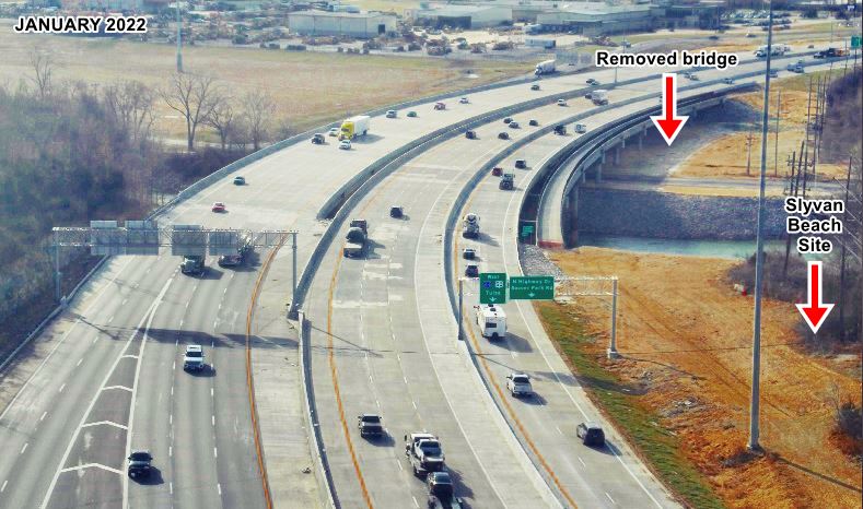
beside the original ones, but were much wider. They carried the second pair of lanes -in those days, eastbound lanes of the 4-lane highway. This bridge was taken down in 2022 as shown below.
Bridge removed in 2022
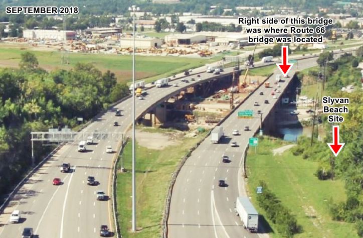
MO DOT upgraded the bridges across the Meramec River between 2019 and 2022 (click on the thumbnail images below for a "Before and After" sequence or see the day-by-day work progress images at the MO DOT site.
The images look west across the Meramec river, the site of Sylvan Beach is on the right. The original Route 66 alignment ran along the now gone bridge on the right side of the image.
This segment of your Route 66 road trip across Sunset Hills ends here. Head west to Fenton, the next town on your journey.

Some sponsored content
> > Book your Hotel in Lebanon

Credits
Banner image: Hackberry General Store, Hackberry, Arizona by Perla Eichenblat
Jack DeVere Rittenhouse, (1946). A Guide Book to Highway 66.
The Ramsay Place Names File


