Route 66 in Williamsville IL
Index to this page
All about Williamsville, Illinois
Trivia, Facts and Useful Information
Elevation: 598 ft (182 m). Population 1,421 (est. 2023).
Time zone: Central (CST): UTC minus 6 hours. Summer (DST) CDT (UTC-5).
Williamsville is a village in the north of Sangamon County, Illinois, on Route 66.
The History of Williamsville
The central part of Illinois has been inhabited for at least 11,000 years, the rivers of this region were explored by French trappers in the mid 1600s, but only during the first years of the 1800s did settlers move out to the vast prairies.
Founded as Benton in 1853 when the railroad reached the area (after the U.S. sentator from Missouri Thomas H. Benton). The name was later changed to Williamsville and incorporated in 1884.
The name: Williamsville
The town was named to honor Col. John Williams (1808-1890) a Springfield merchant. He fought with Abraham Lincoln in the Black Hawk War (1832) and they became close friends.
Route 66 was aligned through the downtown district in 1926 and then moved west in 1940, bypassing it as a beltroad. In 1976 I-55 cut off the town completely.
Hotels and Motels near Williamsville
There is no lodging in town, but there are many accommodation options on Route 66 in neighboring Springfield and Lincoln; you will easily find your room in both cities:
> > Book your Hotel in Lincoln or Springfield
More Lodging Nearby along Route 66
Below you will find a list of some of the towns along Route 66 east and west of this town; click on any of the links to find your accommodation in these towns (shown from east to west):
Along Route 66 in IL
- Hotels in Illinois
- Route 66 Starting point ▸ Chicago
- Lockport
- Willowbrook
- Bolingbrook
- Plainfield
- Romeoville
- Joliet
- Wilmington
- Dwight
- Pontiac
- Chenoa
- Normal
- Bloomington
- Atlanta
- Lincoln
- Springfield
- Raymond
- Litchfield
- Staunton
- Williamson
- Hamel
- Edwardsville
- Collinsville
- Troy
- Glen Carbon
- Pontoon Beach
- Granite City
- East St. Louis
West in Missouri
- Hotels in Missouri
- Florissant MO
- Bridgeton MO
- St. Louis MO
- Kirkwood MO
>> Check out the RV campgrounds in Springfield, Lichtfield, and also in Raymond
The weather in Williamsville
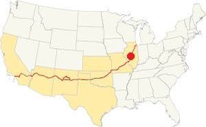
Location of Williamsville on U.S. Hwy. 66, Illinois
The climate in Williamsville is a continental one with humid hot summers and cold winters.
Average temperatures during summer (Jul) are the following; high: 85°F (29.7°C) and Low 65°F (18.1°C). The winter (Jan) averages are the following; High: 34°F (1 °C) and Low: 18°F (-7.8 deg;C).
Annual rainfall is 36.7 inch ( 1008 mm) with a peak of 5.08 inch in July (129 mm) and a minimum of 1.93 in. (49 mm) in January.
Expect snow from Nov. thru Mar. The average snowfall is 22 inch (55 cm).
Tornado risk
About 7 tornados hit Sangamon County (where Williamsville is located) each year. Tornado Risk: learn more about Tornado Risk on US 66.
Map with the alignment of Route 66 through Williamsville

1940 USGS map of Williamsville
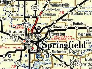
Roadmap of Springfield in 1946. Williamsville is at the top. Source
Click thumbnail map to enlarge
The first alignment of Route 66 in 1926 followed State Hwy 4, and entered the town along Elm St. and then ran parallel to the railway south into the next town, Sherman. The purple line marks the surviving lanes from Elkhart to Williamsville and the 1926 alignment in town. As you can see it is cut at its southern tip, where it is overlaid by I-55's northbound lanes, and at the former junction of Taylor and Elm St. cut off by the 1940s bypass alignment.
The 1940 realignment: A safer alignment was needed (acccidents in the towns were increasing), so a bypass with four lanes was built around the town; see the white line in our custom map. The second set of lanes has been mostly removed except for a short section along N and S Oak Streets (1956 aerial photo).
The Route 66 alignment in Williamsville
Visit our pages with old maps and plenty of information about US 66's alignments in this area.
- Springfield to Staunton IL (1926-30 US66) south from Springfield (next)
- Springfield to Hamel (after 1930) south from Springfield (next)
- Pontiac to Springfield (Williamsville's)
- Chicago to Pontiac (previous)
Williamsville its Route 66 Attractions
Historic Context
In 1946, researching for his classic Guidebook of U.S. 66, Jack Rittenhouse drove the Mother Road from Chicago to L.A., and he mentions Williamsville as follows:
Pop. 649... The town is a quarter of a mile off US 66 (L). There is a garage in the town, but no gas station or other facilities on the highway Rittenhouse (1946)
City Sights and Landmarks
It is evident that Rittenhouse drove along the "Bypass" 66 as the town was off to the left. There were gas stations in town, but not on the bypass alignment: The local highschool yearbook from 1952 mentions Lawrence Irving's Standard Service, Robinson's Auto Service, R.B. Claypool's Standard Oil, Turner H. Claypool's Texaco, Orville Meredith's Marathon Service.
Original 1926 alignment
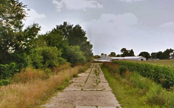
We will drive through town from north to south coming from Elkhart; this is the map with directions to visit and drive the narrow concrete strip that was the original 1926 Route 66 on the north side of town, pictured below:
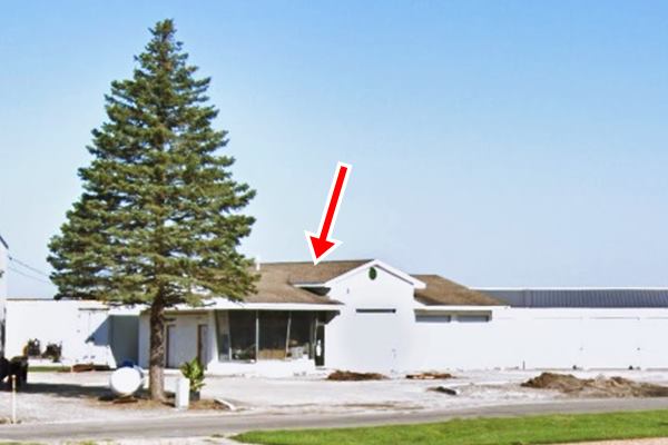
Thomas' Phillips 66 Service
Retrace your steps back to the 1940s bypass turn south (left) and after 100 yards is the junction with North Elm Street. South of this point, Elm St was the original 1926 alignment through Williamsville until the 1940 "bypass" was built.
To your right, almost hidden on the north side of the four-lane 66, is a former Phillips 66 station. You can still see its typical canted plate glass office that looks like an airport's control tower. It opened in the late 1960s serving traffic along the highway, and closed when I-55 bypassed it in 1976.
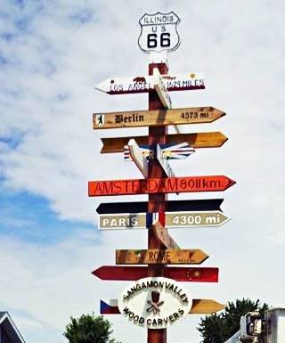
Distances road sign by Williamsville's Library. Source
Williamsville Public Library and Museum
Take a left along Elm St. into Williamsville.
Just ahead, to your right on the SW corner with Lester is the local library at 217 North Elm St.
On the corner is the "distance-to" sign (see image).
Frank's Old Station
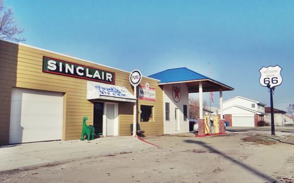
Ahead, to your right at 117 North Elm St. It is a restored 1930's gas station with vintage gas pumps and different signs (Texaco and Sinclair).
It sold different brands of gas over the years, including Marathon. It closed for good in the early 1960s.
It is named after Frank Kohlrus who owned it until 2016. It is a great spot to take a picture.
Ahead, to your right, on the corner of Elm and Main, are two brown Historic route 66 road signs, one points right to the "main" (Bypass) alignment the other points ahead to the "spur" (a dead end). Across the street is the old Railway depot:
Williamsville Railroad Depot and Box Cars
To your left, at 102 South Elm St. The original depot was built in 1854. There is a wayside exhibit with two rstored Union Pacific box cars and some US 66 mementos.
To your left, along Main Street, crossing the tracks is the Downtown Commercial district:
Williamsville’s Downtown
To your right on Main and Pine (NE corner) on the red brick building, there is an interpretative sign; there is another on the SW corner. In the park straddled by the Boulevard, you will see the Memorial Arch, erected in 1919 to honor World War I veterans.
Retrace your steps to Elm. Here you can take a short trip along South Elm the original Route 66 south of Williamsville and back along the 4-lane bypass (map with directions.
Fawn’s Service Station
On the southern tip of town, at 500 S. Old Rte. 66, Williams. Here was Fawn’s Service Station and the now gone Route 66 Café it was located at the southern tip of Williamsville bypass, where it met the 1926 alignment.
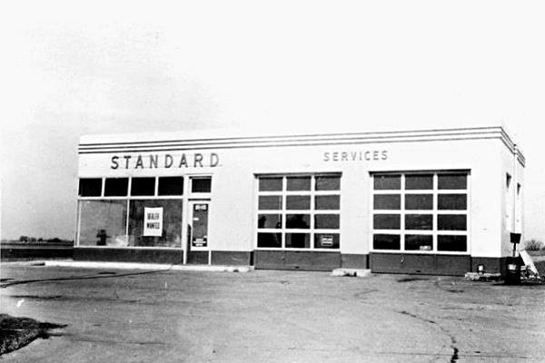
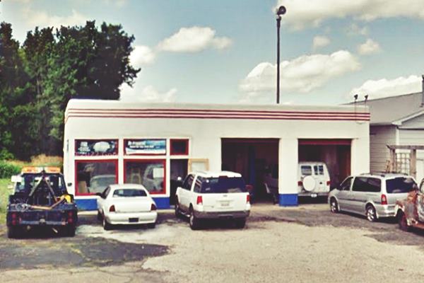
In 1945 Wilbur Fawn bought the Standard Oil service station that had been owned by Fran Finch since 1941 he added a tow truck. The building is still standing, with a two-door garage. It had three pumps. When I-55 was finally completed in 1976 and the old US 66 alignments were cut off. The station closed in 1984. The defunct Route 66 Café was just east of the service station.
Below is a "Then and Now" sequence of the building:
Fawn’s Service Station (when it belonged to Finch) in Williamsville, Illinois
Same spot nowadays:
Continue your Road Trip
This is the end of your tour in town. You will need to take the freeway to reach the next town as Route 66 is overlaid by the interstate south of this point into Sherman.
Turn back and head to the Freeway at Stuttle Rd. (Exit 109) to continue your road trip south towards Sherman

Sponsored Content
>> Book your Hotel in Chicago

Credits
Banner image: Hackberry General Store, Hackberry, Arizona by Perla Eichenblat
Jack DeVere Rittenhouse, (1946). A Guide Book to Highway 66.

