Route 66 in Elkhart IL
Index to this page
Information about Elkhart Illinois
Facts, Trivia & Useful Info
Elevation: 596 ft (182 m). Population 439 (2021).
Time zone: Central (CST): UTC minus 6 hours. Summer (DST) CDT (UTC-5).
Elkhart is a village located in the south of Logan County, Illinois.
The History of Elkhart
Human beings have lived in the prairies of central Illinois since the glaciers retreated some 12,000 years ago. More recently, there probably was an Illinois Indian village on the hill where the town is now located. The native Kickapoos arrived in the mid 1760s from the Great Lakes region and settled on the hill.
The town is located on an ancient "Trace", an Indian Trail that linked Elkhart to Kentucky and the Mississippi in the south and Peoria in the north.
After the arrival of European settlers, the natives were forced to move; an 1819 treaty made them cede the land to the U.S. government and move west. That same year James Latham settled on the hill and became the first settler and squatter in Elkhart.
Logan county was formed in 1839 from Sangamon County and it was named for Dr. John Logan, an Irish born American physician and a pioneer. By then the Kickapoos had all been forced out, west of the Mississippi River and into Oklahoma.
The county built a road that followed the cource ancient Trace; it it later became the "Fort Clark or Peoria Road", and the Pontiac trail was aligned along it in the 1910s.
The Alton & Sangamon railroad (now the Chicago & Alton) reached Elkhart Grove in 1853. This led to the platting of a village in 1855 and its chartering in 1861.
The name: Elkhart
The local native Illinois people believed the hill had the shape of an Elk's heart. Their totem was an Elk heart.
There was a local myth that White Blossom, the beautiful daughter of the chief was courted by a Shawnee and an Illinois warrior. She said she'd marry the warrior who could pierce the heart of an elk. The Illinois warrior did so, and married her.
The village was named Elkhart City, to distinguish it from Elkheart Hill that gave it its name. The hill with 777 feet (234 m), is the highest point in Logan County. It covers 600 acres of timberland and rises like an island in a flat and vast sea of grass.
Route 66 was aligned through Elkhart in 1926; realigned in the 1940s, and in 1958 the new freeway I-55 bypassed the town completely.
Hotels and Motels near Elkhart
There is no lodging in town, but there are many accommodation options on Route 66 in neighboring Springfield and Lincoln; you will easily find your room in either of these cities:
> > Book your Hotel in Springfield
More Lodging Nearby along Route 66
Below you will find a list of some of the towns along Route 66 east and west of this town; click on any of the links to find your accommodation in these towns (shown from east to west):
Along Route 66 in IL
- Hotels in Illinois
- Route 66 Starting point ▸ Chicago
- Lockport
- Willowbrook
- Bolingbrook
- Plainfield
- Romeoville
- Joliet
- Wilmington
- Dwight
- Pontiac
- Chenoa
- Normal
- Bloomington
- Atlanta
- Lincoln
- Springfield
- Raymond
- Litchfield
- Staunton
- Williamson
- Hamel
- Edwardsville
- Collinsville
- Troy
- Glen Carbon
- Pontoon Beach
- Granite City
- East St. Louis
West in Missouri
- Hotels in Missouri
- Florissant MO
- Bridgeton MO
- St. Louis MO
- Kirkwood MO
>> Check out the RV campgrounds in Springfield, Lichtfield, and also in Raymond
The weather in Elkhart
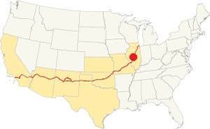
Location of Elkhart on U.S. Hwy. 66, Illinois
With a humid continental climate, Elkhart has wet hot summers and cold winters.
Summer (Jul) average high temperature is 85°F (29.7°C) and the avg. low is 65°F (18.1°C). Winter (Jan) average high temperature is 34°F (1 °C) and the low is 18°F (-7.8 deg;C).
Yearly rainfall is around 36.6 inch (1007 mm) and is highest during summer, reaching 5.08 inches (129 mm) in July (129 mm). It is lowest in winter with 1.93 inches (49 mm) in January.
Snow falls each year between November and late March, and averages 22 inches (55 cm).
Tornado risk
Every year some 7 tornados strike Logan County -Elkhart is located in this county. Tornado Risk: learn more about Tornado Risk on US 66.
Map with the alignment of Route 66 through Elkhart
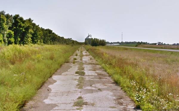
The original highway (1926-40s) was a narrow concrete surfaced two-lane alignment that can still be seen on the north side of town (further down we describe The 1926 alignment at Elkhart). The first segment is a short stretch of road 0.6 mile-long, with a cracked concrete surface you can reach it on the northern side of the silos by Elkhart on the eastern side of modern Route 66. Then the original alignment curved around the western side of the town as marked with a brown line in our interactive map. This segment can be driven.
Later during the 1940s a northbound set of lanes was built where Old Route 66 now runs, as shown in this 1937-47 aerial photo of Elkhart. The original curved section was became the southbound lanes. However, by 1957, the curved segment was bypassed by a second set of lanes cutting across Elkhart to carry southbound traffic (1957 aerial photo).
When I-55 was built, the southbound lanes north and south of Elkhart were eliminated leaving the two lanes that make up modern Route 66. We mark them with a green line in our custom map.
You can see some remains of the old roadbed to your right (street view) on the southern side of town.
The Route 66 alignment in Elkhart
Visit our pages with old maps and plenty of information about US 66's alignments in this area.
- Springfield to Staunton IL (1926-30 US66) south from Springfield (next)
- Springfield to Hamel (after 1930) south from Springfield (next)
- Pontiac to Springfield (Elkhart's)
- Chicago to Pontiac (previous)
Elkhart and its Route 66 Attractions
Things to see in town
Historic context: US 66 in 1946
Jack Rittenhouse wrote his guidbook to Route 66 in 1946 and mentioned Elkhart as he drove past it: "Pop 436... garage; gas... The dozen ancient store buildings which comprise the town are off to the left on the one main street which crosses US 66. No courts here."
Little has changed since then, Rittenhouse's description is still valid.
Stops in Elkhart on your road trip
The 1920s Route 66 roadbed
Drive into the town from the north, coming from Broadwell along the remaining two lanes of the 1940s four-lane alignment. On the north side of town you will see the grain silos to your left. Here, to your left you will see the original 1920s alignment of Illinois State Hwy 4, that became Route 66 in 1926. It runs between the current roadway and the railroad.
It is a 0.6 mile-long roadbed with a cracked concrete surface, pictured below:
Looking south along the 1926 roadbed in Elkhart, Illinois

Shirley Temple Silhouette Statue, Elkhart. Source
The original alignment curves to the west, around the town's western flank, and you can drive it (Map with directions).
Shirley Temple Route 66 Silhouette Statue
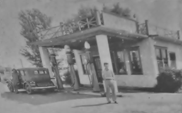
The classic gas stations and cafe were on this alignment, and have long gone such as Tierneys Shell Station and Roof Garden pictured below, Ward's gas station and The House by the Side of the Road, a cafe owned by J. Smith, where young actress Shirley Temple stopped for lunch in 1938. This event is recorded by a Route 66 Silhouette Statue located in downtown Elkhart, at 209 Governor Oglesby St. beside the town's city hall (pictured), there is a roadside sign-exhibit next to it.
On the south side of the curved 1920s alignment, it meets the 1940s one (modern Route 66) at Main Street. To your right, on the SE side of the crossroads is the former Texaco of Fenton Craner and Leo Walsh.
Former Texaco Gas Station
When Fenton Craner (1918-1983) came back from the WWII as a Captain, he married his sweetheart Florence née Bair, and partnering with Leo Walsh, opened a Texaco gas station. He didn't use the typical enamel ice-box Streamline Moderne stype favored by Texaco and designed by Teague. Instead the building had a curved glazed tiled facade:

Elkhart Oil ad, published in 1955. Source

Elkhart Texaco in 1985. Quinta Scott
The place originally had a service bay facing Route 66 on its southwestern tip, and another facing Main, beside the tracks. Two pump islands with two pumps each faced Main St. Below is a current view of the old gas station:
Former Texaco Station in Elkhart, Illinois
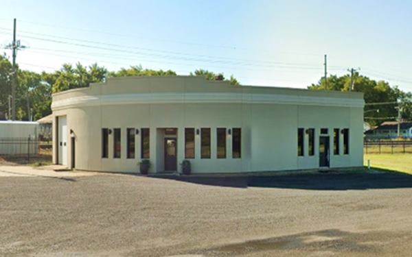
The design was clean, with crisp lines and had a prominent rounded corner and no canopy giving it a Modern look very similar to the barrel shaped Mobil's stations of that period.
Take a left, cross the tracks -grade crossing- and enter the village along its main street, Governor Oglesby Street to visit the historic downtown Elkhart:
Murals
On both sides of the street, on the NE and SE corners of Main and Latham, a Route 66 shield and a mural of Elkhart are painted on the red brick walls of the corner buildings.
Veterans' Memorial Park
To your right, halfway down the block, next to the bank. it consists of a World War I doughboy statue and plaques that honor the names of Elkhart's veterans from WWII, the Korean War and all past wars.
Lincoln Heritage Signs
One block along main, on the SE corner of Bogardus and Gov. Oglesb. During the 2009 celebration of the 200th anniversary of Lincoln's birth, one of the Lincoln Heritage signs was erected across the road from the Village Hall. It tells about the relationship between Abraham Lincoln and Logan County and Elkhart.
Next to the City Hall is the Shirley Temple Shilouette mentioned further up.
Continue through the town and head for County Road 10, a very short drive to visit the sights at Elkhart Hill: the cemetery, chapel and Historic Bridge.
Elkhart Grove Forest Preserve
The Preserve protects the unique ecosystem of Elkhart Hill and spans 136 acres of forest where Blue Ash thrives.
Gillett Memorial Arch Bridge
Landmarks Illinois' Most Endangered Historic Places
It is short 0.8 mile drive, see this Map with directions. To your left is the cemetery with its chapel ahead is the bridge.
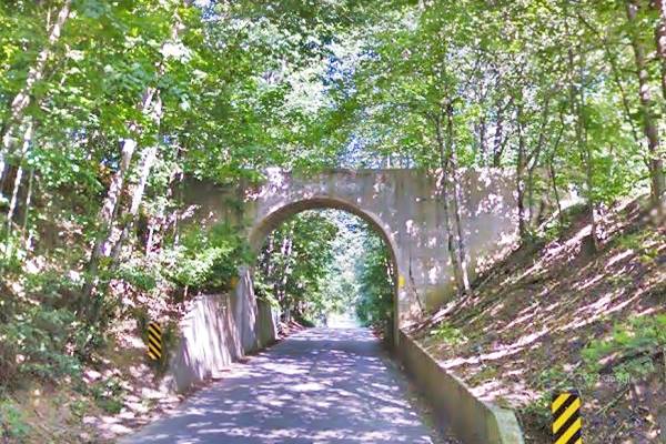
The Gillett Memorial Arch Bridge was commissioned by Emma Gillett Oglesby -she had been the First Lady of Illinois- in 1915 as a memorial to her brother. It is a private owned bridge, and it consists of a concrete single-arch span that linked the family cemetery and the family's estate.
The county wanted to demolish it to widen the highway, but its designation as an Endangered Historic Place means that the county must request permission from the Illinois Historic Preservation Agency (IHPA) or the Illinois Department of Transportation (IDOT). In the meantime work is ongoing for it to be listed in the National Register.
Gillett Memorial Arch Bridge in Elkhart, Illinois
Elkhart Cemetery
Built in 1874, in the woods, it is the burial place of Governor Richard Oglesby and John Dean Gillett who had been a cattle baron.
Gillett's widow, built a chapel in honor of her husband: St. John the Baptist, in stone and Gothic style.
A second "Looking for Lincoln" wayside exhibit is right beside the entrance of the Cemetery.
Edwards Trace
Edwards Trace also known as the "Old Indian Trail" linked the Indian settlements from Kaskaskia in with northern Illinois and maybe even Wisconsin. It passed through Cahokia Mounds (Collinsville on Route 66) and, Edwardsville, Springfield, then Elkhart Hill and Lincoln, where it headed for Peoria.
French explorers and trappers used it during the 1700s and the pioneers followed it in the early 1800s. By the mid 1800s the railway and other roads had replaced it.
It was named after Ninian Edwards who, with 350 rangers, followed the trace in a campaign against the Kickapoo Indians in 1812
Farmers plowed it into oblivion and of the hundreds of miles it once had only some traces can be seen today at Lake Springfield and on Elkhart Hill.
Continue your Road Trip
This is the end of this leg of your road trip in Elkhart. Retrace your steps back to Route 66 and head south to visit Williamsville.

Sponsored Content
>> Book your Hotel in Chicago

Credits
Banner image: Hackberry General Store, Hackberry, Arizona by Perla Eichenblat
Jack DeVere Rittenhouse, (1946). A Guide Book to Highway 66.

