Route 66 in Broadwell IL
Index to this page
Information about Broadwell Illinois
Facts, Trivia & Useful Info
Elevation: 591 ft (180 m). Population 126 (2026 est).
Time zone: Central (CST): UTC minus 6 hours. Summer (DST) CDT (UTC-5).
Broadwell is a tiny village in central illinois, located in southern Logan County on former U.S. Hwy 66
Broadwell's history
Central Illinois was first inhabited after the ice sheet retreated some 11,000 years ago. More recently, Illinois and Kickapoo Native American people lived here when the first European settlers arrived around the early 1800s. However the prairies were not suitable for the farming system of that time and only after the arrival of the railroad was the area effectively settled.
Logan county was established in 1839, at the same time as the Kickapoos had been forcibly relocated beyond the Mississippi River in what was called the "Indian Territories," now the state of Oklahoma.
Around 1840, an inn named "Tantivy" was built 3⁄4 of a mile east of the present village, the Chicago, Alton & St. Louis railroad (now the Chicago & Alton) passed through the area in the mid 1850s and shortly after a station was established there. A village was platted in 1856 by Thomas C. Meyer and his business associates on land owned by William B. Broadwell.
The name: Broadwell
Named for the owner of the land where it was founded: William B. Broadwell. The surname is a locational name from England, and derives from Old English: brād meaning "broad" and wella meaning "spring" or "stream".
The first store was opened by William Sample; and the school opened in 1857. The village incorporated in 1869. The Illinois Traction System linked the town in 1904 and Route 66 was aligned along an existing state highway in 1926, and remained so until it was decertified in 1977.
Hotels and Motels near Broadwell
There is no lodging in town, but there are many accommodation options on Route 66 nearby in Springfield and Lincoln; you will easily find your room in either of these cities:
> > Book your Hotel in Springfield
More Lodging Nearby along Route 66
Below you will find a list of some of the towns along Route 66 east and west of this town; click on any of the links to find your accommodation in these towns (shown from east to west):
Along Route 66 in IL
- Hotels in Illinois
- Route 66 Starting point ▸ Chicago
- Lockport
- Willowbrook
- Bolingbrook
- Plainfield
- Romeoville
- Joliet
- Wilmington
- Dwight
- Pontiac
- Chenoa
- Normal
- Bloomington
- Atlanta
- Lincoln
- Springfield
- Raymond
- Litchfield
- Staunton
- Williamson
- Hamel
- Edwardsville
- Collinsville
- Troy
- Glen Carbon
- Pontoon Beach
- Granite City
- East St. Louis
West in Missouri
- Hotels in Missouri
- Florissant MO
- Bridgeton MO
- St. Louis MO
- Kirkwood MO
>> Check out the RV campgrounds in Springfield and Lincoln
The weather in Broadwell
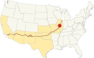
Location of Broadwell on U.S. Hwy. 66, Illinois
Broadwell has a humid continental climate with hot, humid summers, and cool to cold winters.
Winter (January figures): Its average high is 34°F (1 °C), and its average low for winter is 18°F (-7.8 deg;C).
Summer (July figures): has an average high of 85°F (29.7°C) and an avg. low of 65°F (18.1°C).
Precipitation is lowest in January (1.93 in. - 49 mm) and peaks at 5.08 in July (129 mm). Yearly rainfall is 36.7 inches ( 1.008 mm). Snow falls from November through March and averages 22 inches (55 cm) yearly.
Tornado risk
Some 7 tornados strike Logan County each year (Broadwell is located in this county).
Tornado Risk: learn more about Tornado Risk on US 66.
Map with the alignment of Route 66 through Broadwell
The original highway was built as Illinois State Hwy. 4 in the 1920s, and Route 66 was aligned along it in 1926. The two lane highway was upgraded to a four lane divided highway after the mid 1940s. In those days there were no overpasses and all crossroads were grade crossings. When the freeway (I-55) was built , its northbound landes buried the 4-lane US66's southbound lanes. They resurface on the north side of Broadwell. The current "Historic or Old Route 66" through town consists of the former southbound lanes of U.S. Route 66. The new interstate I-55 was completed in this area in 1958 and replaced the old Route 66 with a new alignment further west.
The brown line in our custom map marks the alignment in Broadwell
The Route 66 alignment in Broadwell
Visit our pages with old maps and plenty of information about US 66's alignments in this area.
- Springfield to Staunton IL (1926-30 US66) south from Springfield (next)
- Springfield to Hamel (after 1930) south from Springfield (next)
- Pontiac to Springfield (Broadwell's)
- Chicago to Pontiac (previous)

Broadwell's Route 66 Attractions
Sights & Landmarks
Historic Context
Jack DeVere Rittenhouse mentions the village in his classic "A Guide Book to Highway 66" self-published in 1946:
Pop. 144... gas; grocery; cafe; no garage. Two-score homes surround a tiny depot and the grain elevators which bear witness to the corn growing ability of this region Rittenhouse (1946)
The cafe and gas station he mentions were the now gone "Pig Hip" Restaurant and adjacent filling station. Rittenhouse didn't mention the Pioneer Cabins-Motel as they opened in the 1950s. The village was, and still ism small and the population is almost the same.
Route 66 Road Trip leg through Broadwell
Logan Center Motel (razed)
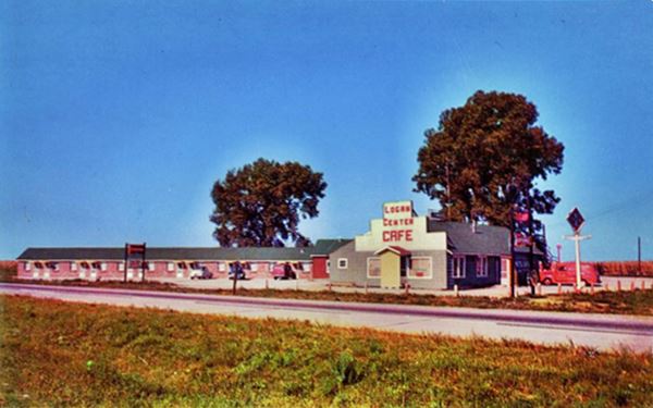
Drive from Lincoln towards Broadwell. The four-lane alignment ends at the access to I-55's Exit 123. from this point westwards the former southbound lanes are buried by I-55's norhtbound ones. Ahead, at the former crossroads with 1200th Street, 2 miles north of Broadwell was the Logan Center Motel, on the western side of the old alignment. It was torn down when I-55 was built over the property. You can see it in this 1957 aerial photograph, and this map marks the spot. Nothing remains of it. Below is a vintage postcard of it that reads "Logan Center Motel, Restaurant, Bar, Service Station man to check your car while you wait or eat... phone 1796 for reservations. F. G. Margonis, Prop."
Continue southbound, and at the northern side of Broadwell, at Logan County Rd. 22 is the access ramp to the freeway's Exit 119. To your right is a brick building belonging to the Logan Highway Dept. And the frontage road of the original four lane here Route 66. The former southbound lanes of the highway have been removed, a wide swath of grass marks where they were. To your left, beyond the railroad is the village proper.
Pioneer Rest Motel
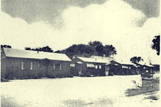
Pioneer Motel 1940s, Broadwell IL. Source
To your right, at 161 West Oak St. Broadwell. Vintage post cards show it as having separate cabins (click on thumbnail to view), but now it is a very run down one story brick building, rectangular shaped with an end gable roof and 6 rooms.
Pioneer Rest Motel in Broadwell, Illinois
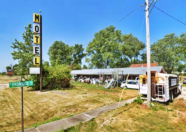
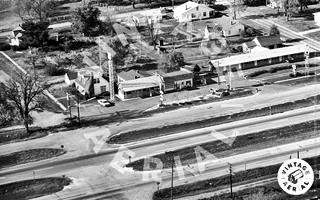
1969 aerial photo Restaurant, gas station, motel.
Click to enlarge
The motel was owned by Bonnie Jean (Edwards) Welch and her husband. She was the sister of Joe Edwards who owned (the now gone) Phillips 66 service station next to it, and Ernie Edwards, who owned the restaurant along the street. The aerial photo taken in 1969 shows all three buildings from left to right: Pig Hip Restaurant, the Phillips 66 station and the Pioneer's Rest Motel.
Next to the motel, south of it is the site of the former Pig Hip Restaurant. The gas station has also vanished.
Pig Hip Marker & Sign
101 West Oak St. Broadwell.
Ernie Edwards (1917-2012) was the owner and operator of the Pig Hip restaurant. Edwards was inducted into the Route 66 Association of Illinois Hall of Fame in 1990. He was known as "The Old Coot on Route 66."
He moved to Lincoln in 1934 and bought the "Harbor Inn" restaurant in Broadwell three years later. In 1939 he changed its name to "Pig-Hip Restaurant," to honor the sandwich that had made it famous.
According to Ernie, the sandwich (which also had a secret sauce) was made with lettuce, tomato, a toasted bun and fresh, uncured ham that came from the left hip. He joked that it was more tender than the right one because pigs scratch themselves with their right hind legs, toughening the muscles there. It's motto was "They made its way by the way they're made."
He finally closed it in 1990 and decided to open the Pig Hip Restaurant Museum on the property, and ran it until 2007 when it caught fire and burned to the ground. The site had been inducted into the "Route 66 Hall of Fame" before it burned down.
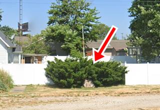
Its valuable collection of Route 66 memorabilia was lost in the blaze. But a granite stone marker with a bronze plaque identifies the spot and honors its memory.
The old sign that attracted customers was also restored to its bright red original appearance as you can see in the image below:
Pig Hip Marker & Sign in Broadwell, Illinois
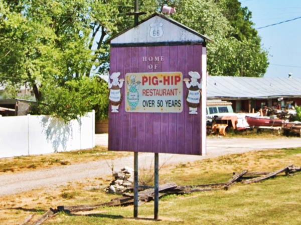
The marker can be seen on the western side of the sign, a stone base, a flagpole and a bronze plaque that reads:
"PIG HIP
RESTAURANT
1937-1991
At Broadwell Illinois
on historic
U.S. ROUTE "66"
Operated for over 54 years by
Ernest L. Edwards, Jr. & Family
Home of the celebrated PIG HIP Sandwich-
baked fresh pork with tomato & lettuce on
a toasted bun with the secret sauce
The PIG HIP Restaurant Museum with
Ernie's fine personal collection of
Route "66" memorabilia & artifacts
was destroyed by fire on 5 March 2007
just prior to Ernie's 90th Birthday
But U.S. Route 66
"The Mother Road"
Endures Forever
A concrete symbol of
America's Freedom & Opportunity
ALWAYS in the hearts and minds of
her sons and daughers"
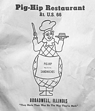
Original Pig Hip napking with logo.
On the markers upper left corner is the logo with the cook with a knife in one hand, the sandwich on a plate in the other and an apron saying "PIG HIP", and his body shaped like a pig hip (see the logo in the napkin's picture).
Continue your Route 66 Road Trip
Just ahead, the frontage road ends. To your left, on the other side of the tracks are the grain elevators mentioned by Rittenhouse.
Return to the old four-lane Route 66's former northbound lanes (present Historic Route 66) and head south to continue your road trip in the next town: Elkhart.

Sponsored Content
>> Book your Hotel in Chicago

Credits
Banner image: Hackberry General Store, Hackberry, Arizona by Perla Eichenblat
Jack DeVere Rittenhouse, (1946). A Guide Book to Highway 66.


