Route 66 in Eastern Albuquerque NM
Albuquerque's Attractions along US 66
A List of Stops and Landmarks
We will use the ❌ symbol to mark those that have been torn down.
1. Eastern Albuquerque (This Page)
- Paradise Club ❌
- Little Beaver Town ❌
- Original 1930s Roadbed
- Holiday Inn East
- Bar-B-Q Inn
- Phillips 66 Gull Wing service station
- Tropicana Lodge, later Nendel's ❌
- Caravan Nightclub neon sign
- Iceberg Cafe in East ABQ ❌
- Rodeo Court ❌
- Steer on a pole
- Eldorado Court later Roma Motel ❌
- Zuni Motor Lodge ❌
- Muffler Man
- Fair Grounds Motel ❌
- Carrico Modern Court ❌
- Sundowner Motel & Bill Gates
- Former Denny's Diner
- Leonard's ❌
- Tracy's Modern Court ❌
- Trade Winds ❌ / Replica Neon Sign
- Honey Dew Drive Inn ❌
- Nod-A-While Motor Lodge / Silver Spur ❌
- American Car Wash
- Cooksey Court, later New Mexico Motel ❌
- Bimbo's Drive In ❌
- Anchor Inn / Bar-X Motel& ❌
- New Chinatown Restaurant neon sign
- Ambassador Lodge ❌
- Coronado Court ❌
- El Sombrero ❌
- American Motor Inn
- La Puerta Motor Lodge
- Luna Lodge
- Piñon Motel
- Lo-La-Mi Lodge ❌
- Bow & Arrow Lodge
- Chevron Gas Station
- Phillips 66 Gull Wing Gas Station
- Loma Verde Motel
- Pioneer Motel
- Texaco Station
- Ace Cafe
- Tewa Lodge
- La Vela Lodge
- Desert Sands Motel Neon Sign
- Hiland Theater
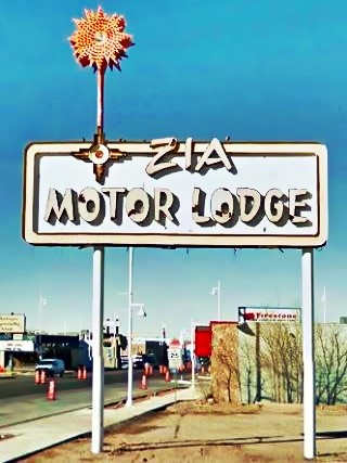
- Zia Motor Lodge
2. Nob Hill
- De Anza Motor Lodge
- Circle K Motor Court
- Bel Air Motel
- Goody's Restaurant
- Martens Tourist Court and Trailer Park ❌
- Comfort Lodge
- Town House Restaurant
- Aztec Court ❌
- Two Gas stations, one gone, Mobil survived
- One of the First KFC in ABQ
- Kurt's Camera Corral ❌
- Original Iceberg cafe ❌
- Rainbow Cafe
- Hiway House Motel
- Pipp's Texaco
- Triangle Cafe ❌
- Tonnie Pegue's Standard Oil Service Station ❌
- Lobo Joe's ❌
- El Oriente Auto Court
- Premiere Motel
- TraveLodge Motel
- The Toddle House
- Nob Hill Motel
- Nob Hill Conoco
- Johnson Standard Station
- Nob Hill Business Center
- Jones Motor Company & Texaco
- Valentine Diner Police Substation
3. Downtown
- Pig and Calf
- 66 Diner
- A Phillips Petroleum Gull Wing
- Cottage Bakery
- Zia Oil Station
- Park Lane Hotel ❌
- Lorlodge Motel
- Central Ave. Underpass
- Hiway House #1 ❌
- Railway Depot
- Glorieta Sation Neon Park
- Yrissari Building: Maisel's first store
- Franciscan Hotel ❌
- Sears
- Hospital
- Little House Cafe ❌
- Crossroads Motel
- Hyatt Chalet Motel
- Whole Hog Cafe
- Imperial 400 Motel
- TraveLodge Downtown
- Hilton Hotel
- El Fidel Hotel
- Kimo Theater
- Lindy's Coffee Shop
- Maisel's Indian Trading Post
- Holocaust & Intolerance Museum of New Mexico
- El Rey Theater
- Firestone Tires
- Downtowner Motor Inn
- Skinner Grocery
4. Old Town & Western Albuquerque
- Chevron ❌
- Lorlodge West
- Bell Indian Trading Post
- World Court ❌
- Desert Inn ❌
- Arrowhead Lodge ❌
- Texas Ann Court ❌
- Moon Motel and Café ❌
- White Way Court ❌
- Katson's Drive Inn ❌
- Country Club Court ❌
- Pueblo Bonito Court ❌
- Casa Grande Complex ❌
- Tingley Beach and Beach Motel ❌
- Rio Grande Bridge
- The Volcanoes
- El Nido Motel ❌
- Rainbow Court
- Sandia Motel ❌
- Duke's Court ❌
- Stop In Court ❌
- Auto-Tel Court ❌
- Miller's Court ❌
- Silver King's Auto Court ❌
- Blue Bell Court ❌
- Hill Top Court ❌
- Arrow Court and Hill Cafe ❌
- Navajo Court
- Dutch Motel ❌
- California Court ❌
- Hill Crest Motel ❌
- Sky Court ❌
- Mile Hi complex
- Covered Wagon Court
- Hubbell Motel ❌
- Oasis Lodge ❌
- Phillips 66 Gull Wing ❌
- Jerry Unser ❌
- Route 66 Conoco
- Route 66 Travel Center
- Capri Motor Hotel
- Horn Oil Co. Motor Lodge
- Sandia Theatre
- Old Town of Albuquerque
- San Felipe de Neri Church
- Tower Court
- El Don Motel
- Monterey Motel
- Country Club Court
- El Vado Auto Court Motel
- Relict Motel Signs: Cibola and Super 6
- El Campo Tourist Court
- La Hacienda Camp
- Siesta Court
- Americana
- Western View Diner and Steak
- Adobe Manor
- Westward Ho Motel
- French Quarter Motel
- Grandview Motel
5. Fourth St. Route 66
- Cavalier Court ❌
- Crossroads of Route 66
- Ruffin's Texaco #1
- Horn Oil North 4th St.
- Ruffin's Texaco #2 ❌
- El Camino Motor Hotel
- King's Rest Court ❌
- Court John ❌
- Madonna of the Trail
- Monkbridge Manor ❌
- Luke Apartments
- Clyde Miller Tire & Service Station
- Texaco Gas Station
- Scott's New Motel ❌
- Barelas-South Fourth Street Historic District
- Hudson Auto Sales
- B. Rupee Drugs
- Tasty Freeze Drive In
- Durand Motor Company
- Hi-Way Service Station - Horn Oil
- Sinclair Service Station
- Magnolia Service Station
- Navajo Super Service Station
- Red Ball Cafe
- Fito's Cafe

Eastern Albuquerque attractions
Along Route 66 From Sandia to Nob Hill
In this page we describe the classic Route 66 sights from east to west, starting west of Carnuel's Elephant Rock, at I-40s Exit 170. We will head west across Albuquerque and end this leg at Nob Hill.
We will use the ❌ symbol to mark those that have been torn down.
Paradise Club ❌
The first building on the site was Fernando Selva's Ranch-Resort, a roadhouse bult c.1890; a dance pavillion was added in 1925; it burned down in 1940 and the Paradise Valley Dude Ranch was built there. It became the Paradise Club in 1951. Over the years it housed Dick Bills bar, until becoming a feed store in 1970 under the name Spear Cross Ranch. The current building occupies the site of the feed store that burned down in 1996. Street view of the spot nowadays
Little Beaver Town ❌
Just 0.6 mi. west is the Route 66 Open Space, one of the city's outdoors recreation areas. It has no infrastructure, only a dry patch of desert usde by hikers. This was the spot where a Far West themed park was built in July 1961. It held reenactments of gunfights, a Far West town with a stagecoach, small scale train, saloons, hotel and even can-can dancers.
It was inspire by Disneyland's success and built around two comic strip characters, Red Ryder and his tiny Indian pal, Little Beaver.
They were the creations of Fred Harman (1902-1938); they featured a radio show and movies. The comic strip was a success from 1938 until the mid 1960s, when kids enthusiasm for cowboys waned as they became more interested in the Space Age.

1948 Red Ryder comic cover. Source

1962 view of Little Beaver Town, US66 Albuquerque. Source
The project failed; The freeway was opening and it bypassed Route 66. The nearest exit less than a mile from the nearest exit, but its layout didn't guide visitors east towards the park. Most people just didn't leave I-40 to visit it. It closed in 1964.
There are ruins and worn foundations among the bushes at the Route 66 Open Space; In this Satellite view, the red marker shows where some crumbling concrete stairs are located. Check out this 1967 aerial photo of the site.
Original 1930s Roadbed
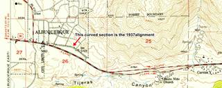
The original 1937 highway can be seen here, on the right side of the freeway (green line in our custom map) and also in the thumbnail map -click on it to enlarge it.
This quarter mile long, curved segment has survived and you can walk along the old roadbed.
It is pictured below:
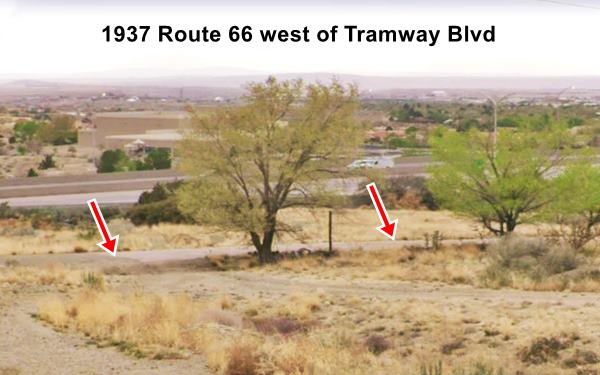

1937 roadbed nowadays Credits
As traffic grew, a safer and straighter highway was needed so a four-lane highway was built in the 1950s with straighter lanes. We marked them with red and blue lines in our custom map. The image below looks west along the four lane alignment where I-40s Exit 167 offramp now begins.
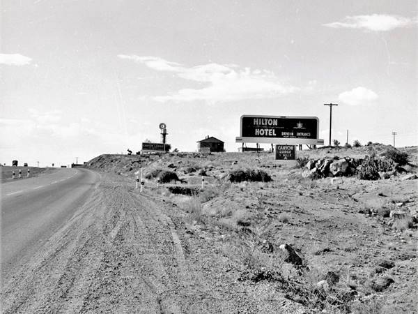
This four-lane alignment was buried by I-40; and the same spot where the picture shown above was taken is now under the freeway's westbound lanes (same spot as it is nowadays). So a new extension to Central Ave was built east to carry I-40s frontage Rd., NM 333.
Central Avenue
Zingg's ❌

Zingg's Cafe, gone. Source
Click to enlarge
At 13611 Central NE (Map marking the spot), Walter A. Zingg opened Zingg's Steak House Coffee Shop, "A Good Spot to Stop...Located at the foot of Tijeras Canyon... We specialize in fine foods at moderate price."
This area at Tramway and Central Ave. was mostly empty space in the 1950s, just a few gas stations and some motels along Route 66 west of this point. The first signs of an urban area appeared at Wyoming Blvd. three miles further west.
Western Skies ❌
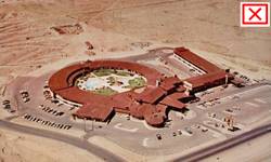
Now gone Westernskies motel. Source
Click to enlarge
On the southwestern corner at 13400 Central Ave. S.E. and Tramway Blvd was the Western Skies hotel (aerial photo taken in 1967) that opened in 1959 and had a round shape. It had "250 roooms with every hotel service pat Motel rate"; a 60 foot heated swimming Pool, cocktail lounge, conference center and celebrity visitors such as Elvis Presley, President Kennedy, Kirk Douglas and Liberace.
It decayed over the years and was torn down in 1988. Smith's supermarket was built on the property.

Now gone Texaco, Albuquerque Route 66. Source
Click to enlarge
Texaco ❌
To the right, just beyond Tramway at 13301 Central Ave. N.E. was a Texaco station that opened in 1969 just where the McDonald's now stands.
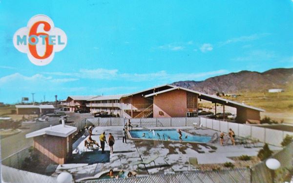
6 Motel
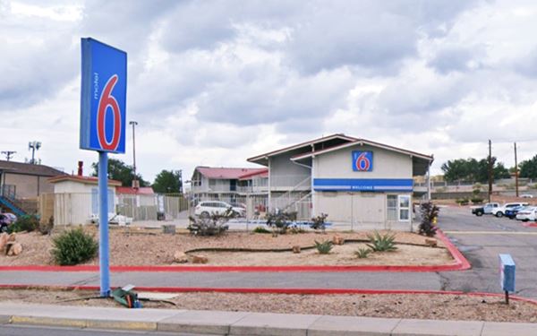
To your right, 13141 Central Ave. N.E. This property is still operating as a motel. It's 1970s postcard tells us it had "124 units, pool, TV." Below is a "Then and Now" set of images:
Same place nowadays; the long overhanging eaves are gone, but the building is there:
Canyon Motel ❌
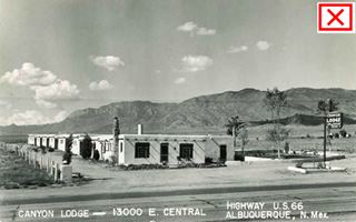
Canyon Lodge (gone) c.1940s. Albuquerque Route 66. Source
Click to enlarge
Ahead, at 13001 Central Ave. N.E., to your right is the site of the Canyon Lodge, a vacant lot (St. view) it later became the "Canyon Motel", "Where Comfort is Assured Year Round"; it had a heated pool and "16 modern Units with private Baths" it was owned by Baxter E. Caviness (1899-1964) and his wife Fannie. It opened around 1946 and Mrs. Caviness ran it until 1969 when she sold it.
American Motor Inn
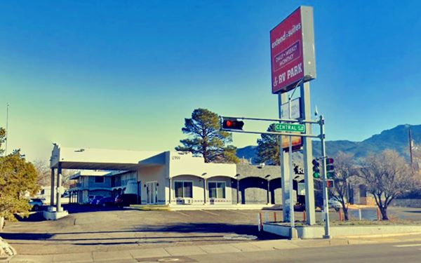
Next to it, at 12999 Central Ave NE, Albuquerque is another motel and RV Park that opened as the American Motor Inn in the 1960s with "Googie" style architecture of bold geometric space-age lines. These classic lines have now been concealed with a Pueblo-Spanish Revival facade with pink adobe-like stucco, arches and rounded shapes.
The postcard below read: "A modern Oasis in the Heart of Indian Country. 52 completely new Modern Units... Your Hosts - The Henry Martins (Hank and Mary)." Later it added a final "A" to its name, becoming the "Americana".
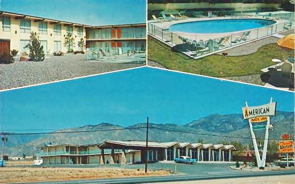
Nowadays, the original layout is there, but with softer lines:
Holiday Inn East
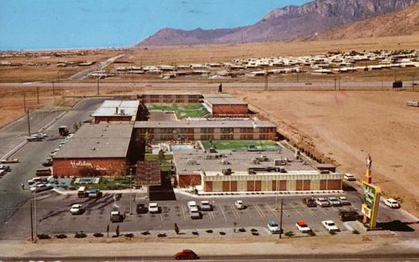
To your right, at 12901 Central Ave N.E., with a bar, restaruant, 300 rooms and two swimming pools. The postcard is from the 1960s. The "Then and Now" pictures show that the left wing with its large wall (now without the Holiday Inn sign on it) and the inverted pyramids on the entrance canopy are still there. The right wing has gone and a gable roof building has been added to the canopy. Since 2018 it is an apartment complex, the Four Hills Studio, previously it had been a motel, the Deluxe Inn Suites since the late 1990s.
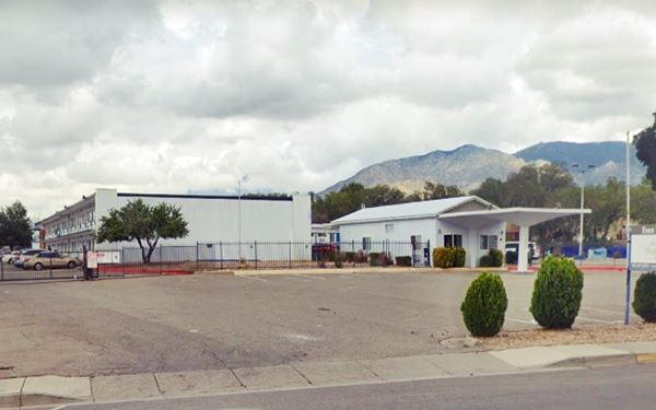
Two 1960s gas stations
Next door at 12831 Central Ave NE is a tire shop, formerly a gas stastion, with a flat canopy, three multi-window service bays and tire a former gas station from the early 1970s.
Across the highway, at 12830 Central Avenue SE is a Ranch style Shell gas station. This style was introduced in 1957. It has a low sloping gable roof with brick finish and a chimney-like extension rising from the roof where the logo was displayed. Pictured above.
Phillips 66 Gull Wing service station
To your right, at 12701 Central Ave NE. It appears in a 1951 aerial photo of this area. In the 1960s Phillips Petroleum Co. standardized their filling stations across the US and adopted a modern Space-Age design with a triangular "gull-wing" canopy which was supported at its narrow tip by a pole designed to look like an oil derrick. A revolving Phillips 66 sign stood at the top of the pole. This is the first of four gull-wings in Albuquerque, second one is just ahead, the third Gull Wing service station is further west. The last one has gone, the Acoma Phillips 66 ❌.
> > Learn more about Phillips 66 Gull Wing stations on Route 66
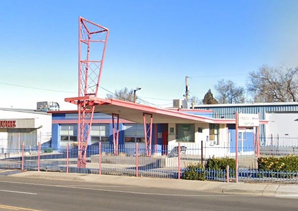
Shamrock Station
The "Then and Now" pictures below show a former Shamrock gas station on the NE corner of Eubank and Central (10401). The gas prices are unbelievable!

Shamrock service, Route 66 ABQ. Source. Click to enlarge
Bar-B-Q Inn
Drive west. You will see modern fast food outlets and car dealerships along the highway. Then, to your right at 9901 Central N.E. is the Bar-B-Q Inn, "Featuring the best Hickory Smoked Barbeque and Charcoal Broiled Steaks in the Southwest".

Bar-B-Q Inn. Albuquerque NM c.1960s Source.
Click image to enlarge
On the next corner, to your left, at 9710 Central Ave SE, on the SW corner with Altez SE is a historic motel, the La Puerta Motor Lodge:
La Puerta Motor Lodge
Listed in the National Register of Historic Places & State Register
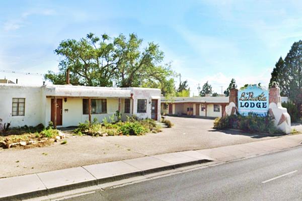
This classic motel is both a State and a National Register site. Ralph Smith built its units in 1949 and the office in 1952, he ran it with his wife Sadie. They had also owned the now gone Eldorado Court which they sold to build the La Puerta. They sold it to the Bauers in 1954 who have owned it since.
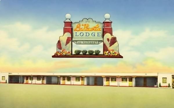
It is still open but focuses on locals with mid term rentals. It's classic sign is
still standing, untouched. "La Puerta" are the Spanish words for "The Door".
La Puerta Motor Lodge in a vintage 1950s postcard
Below we can see its current appearance:
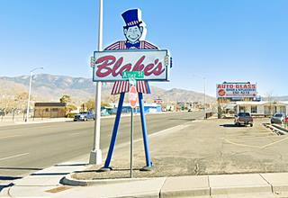
Blakes Lotaburger born in Albuquerque
On the southeast corner is a Blake's Lotaburger created by Blake Chanslor in 1952; he was a WW II Navy Veteran who had moved to Albuquerque from Texas and opened the first LOTA Burger here in ABQ. He also created the green chile cheesburger. The chain has 74 locations mostly in New Mexico, but also with in Texas and Arizona.

First LOTA burger store. Albuquerque NM c.1950s Source
Head west; the motel strip of Route 66 began here, and extended across the city.
Luna Lodge

Luna Lodge early 1960s. Albuquerque Route 66. Source
Listed in the National Register of Historic Places & State Register
9119 Central Ave. NE, Albuquerque, NM.
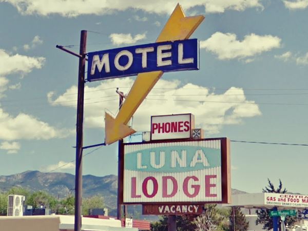
Built in 1949 it was the one of the easternmost hotels in town. It is a U shaped property with 28 units built in the classic Pueblo-Spanish Revival style with projecting wood beams and stucco walls. Now it is a housing facility, and its name "Luna" is Spanish for "Moon".
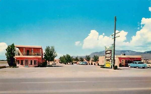
The classic neon sign with an arrow points the way for the guests. It was added in the late 1950s or early 1960s as it does not appear in the postcard below, postmarked in 1958, yet it figures in the postcard with a Ford Falcon and that model was made after 1960.
Its postcard offered "First-Class Accommodations - Excellent dining Room - Heated Swimming Pool... with a beautiful view of the Sandia Mountains."
1950s postcard (sign does not have the arrow)
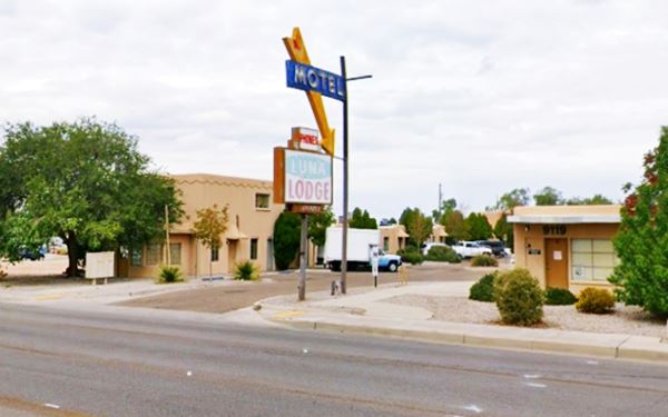
As we can see in the following image, it has kept its original appearance (the trees have grown) but its sign is more attractive now, with the arrow.
The Luna Lodge as it looks today
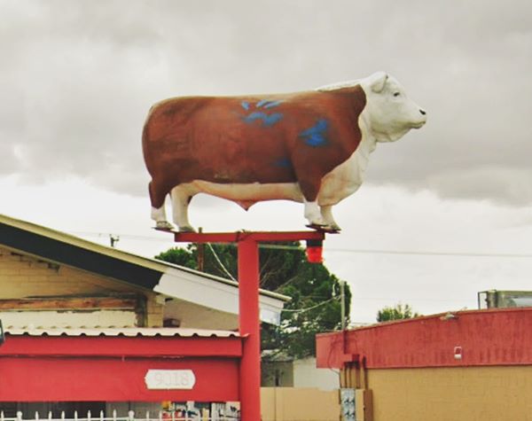
El Sombrerete / formerly Town House Restaurant (steer at the top of a pole!)
To your left at 9018 is a Mexican restaurant, with a wacky neon sign: a life-sized Hereford steer atop a pole. Originally this was the second location of the classic Greek steakhouse the Town House Restaurant in Nob Hill (we describe it in our second page on US 66 in ABQ, the steer came from there).
It closed in 2018 after the untimely death of Constantine "Dino" Argyres, 57, in Dec. 2018. He had reopened it in 2012 and co-owned it with his father George.
Chief Lodge

Former Chief Lodge. St. view
Click to enlarge
Ahead at 8915 Central Ave. NE, to your right is another classic Motel that appeared in the 1959-1977 Motel listings, the "Chief Lodge". Now an apartment complex.
Tropicana Lodge, later Nendel's ❌
At 8814 Central Ave SE, the Tropicana Lodge's postcard below promoted it as "A beautiful new Motor Lodge complete with tiled baths, tub and shower. Thermostatic-controlled wall furnace. Franciscan modern furinture. Wall-to-wall Carpeting." Later it operated as "Nendel's Value Inn." See this Street view while it was still standing. It was torn down in late 2015. The motel's sign is still there. Pictured below.
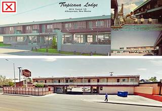
Tropicana Lodge and Nendel's motel.Source
Click to enlarge

Nendel's neon sign, Route 66 Albuquerque. St. view
Click to enlarge
Across from Nendels at 8813 Central NE, is an auto dealer in a former gas station that opened in 1963. No canopy, no pumps, only a box-shaped two-service bay gas station with a glass pane corner office and a two part roof -higher over the service bays (see picture).
Piñon Motel
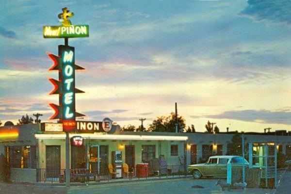
Ahead, to your right, at 8501 Central Ave NE, Albuquerque is the "Piñon Motel" it opened in 1946 and was mentioned by Jack DeVere Rittenhouse in his 1946 classic "A Guide Book to Highway 66".
Piñ on is the name of a local pine tree, from the Spanish word "Piñon" or pine cone; it is pronounced pin-ee-on.
It was owned by the Muellers it had "Free Television - Air Conditioned - Automatic Heat.... Below is a postcard, the car looks like a 1962 AMC Rambler Ambassador.
Piñon Motel in a vintage 1960s postcard
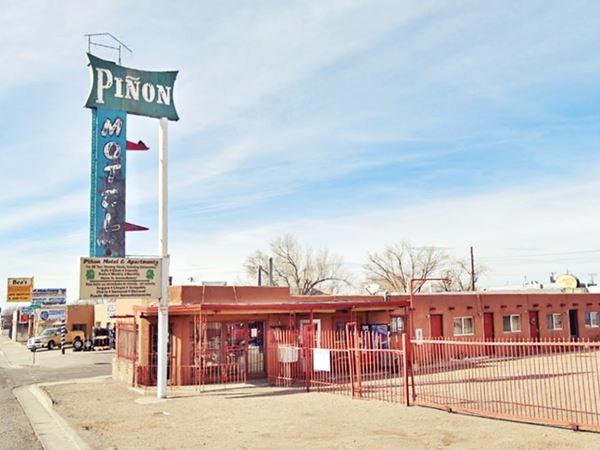
Below we see its current appearance, a motel with short and longterm rentals. The sign has lost the rear part of the two upper arrows but the word Motel is there, on a faded blue background. The lower arrow is concealed by the white box-shaped sign. Its upper part has also been altered.
The Piñon Motel as it looks today
Lo - La Mi Lodge ❌

LO-LA-MI Lodge business card. Source
Mentioned by Rittenhouse in 1946, the Lo-La-Mi Lodge and Trailer park was located at 8500 Central SE, to your left, where Super 6 Tokyo Auto Service is now located. Its card (pictured) tells us it had "Parking for 100 trucks... swimming pool" advertising in the 1960s mentioned "12 four - room apartments." It was originally ran by Guido Giomi (1897-1991) and later by Ed Geiger.
The buildings along its western flank can be seen in this 1951 aerial photo and in this street view.

Across Virgina St. NE, to your right, on the NW corner is Miguel's Tire Shop. This was a gas station that opened in 1949, it has an office on the left side of the property (Street view).
Bow & Arrow Lodge
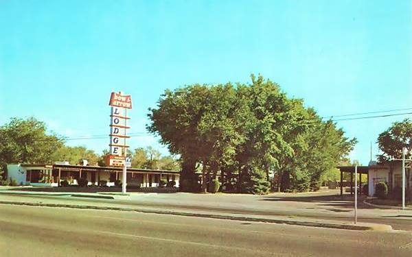
On the next block, to your left at 8300 Central Ave SE, Albuquerque.
The first motel at this address was the "Urban Motor Lodge". The postcard below tells us: "Recommended by Duncan Hines... all private conveniences... Mr. and Mrs. L. F. Morgans, operating owners."
It opened in 1941, and Rittenhouse mentioned it in 1946. It changed hands and name, becoming the "Bow & Arrow Lodge". Its poscard announced that it was "Conveniently located, near Sandia & Kirtland Military Bases... one of Albuquerque's nicer Motels... Mr. & Mrs. Robert E. McMann, Mrs. Waltreen Blanchard, Owners"
Duncan Hines
Duncan Hines (1880-1959) was a traveling salesman for a printer based in Chicago. He drove across the country on his job and in 1935 he put together a list of 475 restaurants around the nation where travelers could get a good meal he self-printed it and sold it for $1 each. In 1938 he added another list with places to spend the night.
Hines was the first to rate lodgings and restaurants in America. Motels paid a fee to appear in the list.
Urban Motor Lodge, later the Bow and Arrow:
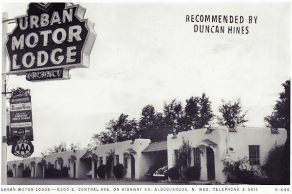
Bow & Arrow Lodge in a vintage 1960s postcard
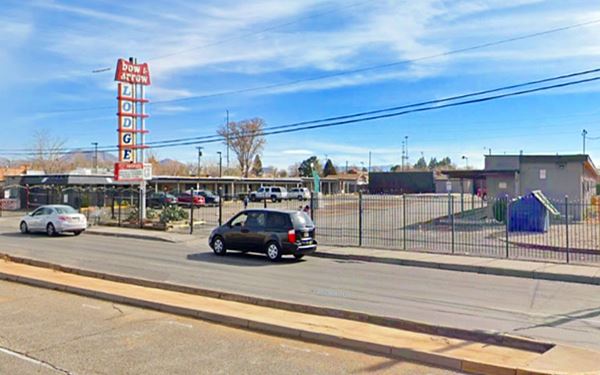
Its sign is the same, now encircled by a steel fence. There are fewer trees, but the motel is still in operation.
El Jardin Lodge ❌

El Jardin Lodge and Cafe 1950s.Source
Click to enlarge
As you drive west you will pass 8100 Central Ave SE, to your left, where the now gone El Jardin Lodge and Cafe once stood (later it was the Route 66 Inn torn down in 2006 to build the Ed Romero Terrace apartments). Jardin is Spanish for "garden". It had fifty cottages and was owned and ran by Mr. and Mrs. M. Markey. Their slogan was "Tomorrow's Hotel Today."
Staggs Chevron Station

Staggs station being built in 1948 Source
Click to enlarge
Two blocks ahead, also to your left, at 7918 Central Ave SE, Albuquerque is a vintage Chevron Station built by Ted Formhals and Son in 1948 and owned and operated by George W. Staggs. Now is is hidden under a large billboard. It has a two-door garage facing Route 66 and an office with a curved glass-brick wall on the corner of Rhode Island with three more service bays.
Don't miss the cilindrical tower concealed by the billboard (red circle in image below). It was built in "Streamline Moderne" style.

Present view of the Chevron Gas Station. A. Whittall. Street View
Click on image to enlarge
Former Motel (?)
At 7900 Central Ave SE. The 1951 aerial photo of the property next to Staggs Chevron shows a U-shaped layout with a central office(?) building and cars parked by the units. It was surely a motel but by 1967 it had acquired its present appearance, with the surviving central building and the tip of the easternmost wing. See picture above. Now it is an auto repair shop (Dependable Auto).
Across Pennsylvania St. SE at 7810 Central Ave S.E. to your left, is a gas station from 1963, with an unusual trapezoidal shaped flat canopy (St. view) now it is a car dealer.
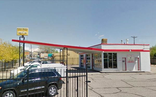
Second Phillips 66 Gull Wing Gas Station in ABQ
On that same block, at its western tip (7800 Central Ave SE) is the second Phillips 66 Gull Wing gas station pictured below. Now it is a used truck dealership (Fulton Motors). They have been selling all type of light trucks and vans since 1960.
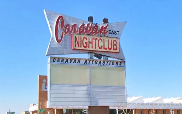
Caravan Nightclub neon sign
At 7701 Central Ave NE, to your right, on the NE corner of Grove St. and Central Ave. Is a classic neon sign. The Nightclub opened in 1961 as the Crescendo Club. It became the Caravan East in 1963, a country music spot. It was Albuquerque's largest Western Music club in the 1970s. It closed for good in 2016 and was torn down to make place for the Public library. Its sign has survived on the corner.
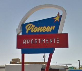
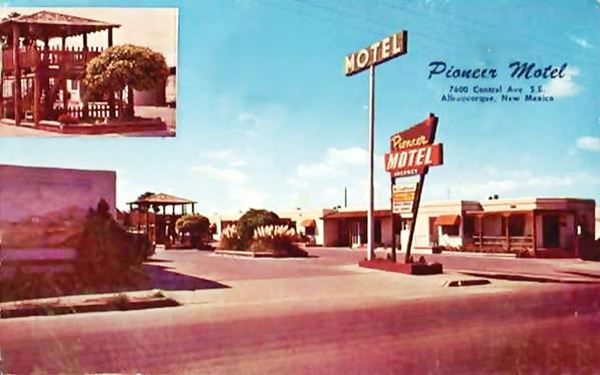
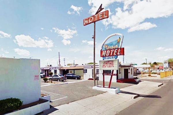
Pioneer Motel
To your left, at 7600 Central Ave SE. The former Pioneer Motel is now an apartment complex that has kept its original neon signs and given them a modern vintage touch.
The "Pioneer Luxury Court" or "Pioneer Motel" was built in 1949. Mr. Bogan Higgs (1900-1955) ran it briefly from 1951 to 52.
Notice the wood pergola that stood by the now gone swimming pool.
Its postcard shown below, from 1961, announced "...Near good restaurants. Everything modern... Singles and doubles; kitchens; tubs and showers. TV Sets...."
Pioneer Motel in a vintage 1950s postcard
Below you can see the Pioneer while it was still a motel in 2017. The tall slender sign topped with the word "MOTEL" has since been taken down:
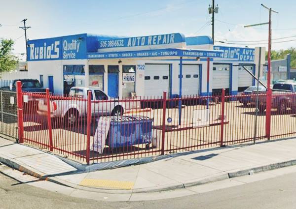
Teague Texaco Station
Just ahead, to your left, on the SW corner, at 7522 Central Ave SE, Albuquerque is Rubio's auto repair shop in a former Texaco Station that dates back to 1948 and has the classic Texaco design created by Walter Teague in the 1930s. It is an "Oblong Box Gas Staton" with a rectangular plan it is softened by Streamline Moderne curves on the corners and on the two crests that top the flat canopy. It has four service bays that face Route 66.
>> Learn all about the Teague-style Texaco service stations along Route 66
The Old Texaco gas station today:
Former Gulf Station
Across Central Ave. at 7519 (to your right) is another former gas station (Sandia Car Sales). This one opened in 1954. Its canopy wit angled (inward sloping) eaves tells us it was a Gulf station. It has a glassed corner office, empty pump islands and two service bays.
Loma Verde Motel
Also to your right, next to the old Gulf station, at 7503 Central Ave NE is the former Loma Verde Court, a name that means "Green Hill" in Spanish, was built c. 1950 with 12 units and is still open offering monthly rentals. It has kept its original neon sign but painted green.
It was owned by Mr. Oscar Stephens until the early 1960s, when after his deth it changed its name to Loma Verde Motel.
Loma Verde Motel in a vintage 1950s postcard
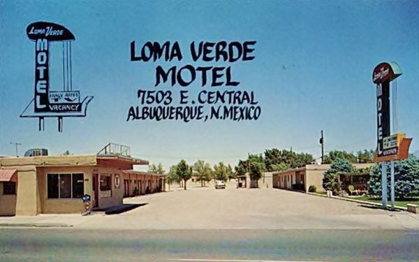
Below is its present appearance, as an apartment complex, Loma Verde Studio:
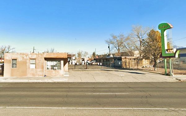
On the next block at 7407 Central Ave NE, to your right where the American Inn & Suites is now located, in the 1950s was the La Mesa Court, later renamed La Mesa Motel and in the early 2000s, the Ambassador Inn. You can see it in this 1951 aerial photo as a long single story set of units with trees.
Zuni Motor Lodge ❌
To your left, where the modern Cinnamon Tree Apartments are now located (7218 Central Ave. SE) was Agnes and Johm Farr's motel. It had 40 Colonial-style units offering "Every comfort and service to the seasoned traveler."

Zuni Motor Lodge (gone) c.1940s. Source
Click to enlarge

Rodeo Court (gone) c.1940s. Source
Click to enlarge
Rodeo Court ❌
To your left, where the Talin Market is located, there were two motels. The first is this one, mentioned by Rittenhouse in 1946, on the SW corner of Central and Alcazar St. SE. at 7118 Central Ave SE. Surprisingly the postcard has the wrong address written on it: 7117 instead of 7118.
Eldorado Court - later Roma Motel ❌
Adjacent to the Rodeo Court on the SE corner of Central Ave and Louisiana Blvd. SE, was the second motel, the now gone Eldorado Motel, later renamed Roma Motel.
Ralph and Sadie Smith owned this now gone motel (to your left) at 7102 Central Ave. S.E. They had met here in 1943 when Ralph was stationed at Kirkland during WWII. They married in 1945 and bought the Eldorado. They sold it to build the La Puerta Motor Lodge on the eastern side of town. This is an aerial photo from 1967. Then it became Roma Motel it was torn down in the 1970s.

Eldorado Court (gone) c.1940s. Source
Click to enlarge

Roma Motel c.1950s.Source
Click to enlarge
May Cafe Muffler Man

May Cafe Muffler Man. Credits. Click for St. View
This is a great classic, recently restored, and located on the SW corner of Louisiana Blvd SE and Central Ave. Across from the former Roma Motel at 11 Louisiana Blvd SE behind the KFC. See this Map showing the spot.
The "Paul Bunh Yan" is the eye-catcher for May Cafe, a Vietnamese cuisine restaurant in a small mall.
Paul Bunyan is perched on the top of a pole, on the property's back wall, above the restaurant's roof. May Café was given the Route 66 Heritage Award for getting the statue restored after it had deteriorated and even spent some times without its arms.

Tracy's Modern Court ❌

1940s postcard Tracy's Modern Court. Source.
Click image to enlarge
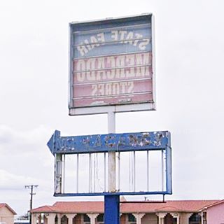
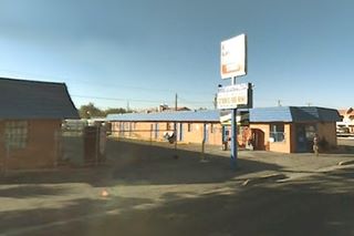
On the next block, to your left, at 6808 Central Ave. SE, is an empty lot with a decaying neon sign where you can still make out the word "Vacancy" on the peeling and faced blue background. Its postcard tells us it offered "Rooms & Apts. Private Showers, Steam Heat, Frigidaire." It was mentioned by Rittenhouse in 1946. It was still standing until the mid 2000s, and then torn down. Below is a view from 2007 and its surviving neons sign.
Adjacent to Tracy's is another fading Y-shaped neon sign to the east (street view) belonged to the Biq Texas BBQ Restaurant that operated from the mid 1960s to 2015.
Adjacent to the motel at 6700 Central Ave SE is a greatly altered former Phillips 66 gas station and auto repair shop that opened in 1949. Next to it is the Luxury Inn, built in the early 1990s after Route 66's demise.
Leonard's ❌

1950s picture of Jotters Ace Café. Source.
Click image to enlarge
Across the street from the Phillips 66 at 6616 was Leonard's Fine Foods, its postcard boasted "No Finer Foods Anywhere." It opened in 1949 and was ran by Margaret and Leonard Grossman. It changed name in 1961 to Johnny Farmer's Restaurant. A tragic event took place at the package store at the restaurant on midnight July 4, 1962: employee Gloria Monson was found lying on the floor behind the counter with a bullet wound in her forehead. She died as a result of the gunshot wound.
A suspicious fire in 1963 burned the place down. Now an upholstry store stands on the property.
Guest Court ❌

1940s postcard Guest Court. Source.
Click image to enlarge
Next to it, at 6606 Central Ave SE, was the Guest Court (current St. view), now it is an empty lot by New Mexico Title Loans. It was torn down in the mid 1960s. You can see its U-shaped layout, with a central office on this aerial picture from 1959.
Jotter's Ace Cafe
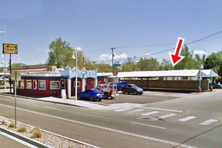
Ahead, to your left at 6500 Central Ave SE, Albuquerque. The building is still there, though it has lost its gabled roof. The car park area still has its roof (red arrow). Their advertisement in the 1969 phone book read "Jotter's Ace Cafe & Drive In - Same location since 1953 - Open 24 Hours a Day - Serving Broastred Chicken to Go."

1950s picture of Jotters Ace Café. Source.
Click image to enlarge
Fair Grounds Motel ❌
To your left, at 6522 Central SE was the Fair Grounds Court (later changed Court to Motel) it had a U-shaped layout with a central office and court. You can see it in this aerial photo taken in 1951. Now it is an empty lot next to Bombay Spice. It was owned by Mr. and Mrs. W. P. Jones and had "Modern Cabins... Innerspring Mattressess... Some Cabins with Kitchen." Rittenhouse mentioned it in 1946.
Later it changed its name to the "Sand & Sage Motel" owned and operated by Agnes and George Young.

Fair Grounds Motel (gone) c.1940s. Source
Click to enlarge

El Rey Auto Court (gone) c.1948. Source
Click to enlarge
El Rey Auto Court ❌
At 6322 Central Ave SE (left) where the Sonic is, once stood the El Rey Auto Court with "Reasonable Rates - Modern Rooms. Kitchenettes," owned by Mr. and Mrs. E. W. Emsing.
Sundowner Motel & Bill Gates
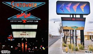
To your left, at 6101 Central Ave ST was the Sundowner, it had a typical 1960s decoration with a modern neon sign (still standing though greatly altered).
Its matchcover promoted it as having "Dancing - Entertainment - Guest Controlled Refrigerated Air Conditioning - Dancing Color Fountain - Courtesy Coffee in Rooms - Complimentary TV - Radio - Music."
But it gradually slid into disrepair and was the den of drug addicts and prostitutes. Fortunately it was bought by a local developer who reconverted it into housing for the low-income segment, offering 71 refurbished units (2022 view).

Sundowner 1970s, US66. Source. Click to enlarge
Bill Gates and the Sundowner Motel
Route 66 Trivia; Paul Allen and Bill Gates who were based in Boston in 1975 developed a software based on BASIC language for the Altair 8800 computer, and traveled to Albuquerque to demonstrate it to the company that made it, MITS, that was based in ABQ.
Allen quit his job in Boston and Gates dropped out of Harvard when MITS hired them to develop the software. The duo, stayed at the Sundowner Motel, and founded Microsoft Corp. in Albuquerque in July 1975.
They eventually moved to Bellevue, Washington in 1979.

Carrico Modern Court (gone) c.1940s. Source
Click to enlarge
Carrico Modern Court ❌
Ahead, on the SE corner of San Pedro Blvd. and Central Ave. was the Carrico motel with a U-shaped distribution that survived until the late 1980s before it was torn down. A Circle K station stands on the property nowadays (6300 Central Ave. SE). It had 20 units and was owned by C. Simms and B. Raglin.
Former Denny's Diner
Kap's Cafe at 5801 Central Ave NE, on its NE corner with Alvarado Drive, is a former Denny's Diner with the classic "Boomerang Roof", a design from the early 1960s by Armet & Davis that gave it a Space Age look. There is another Denny's further west in Albuquerque: the Whole Hog Cafe. Across the street, also to your right is a Classic Route 66 motel:
Tewa Motor Lodge
5715 Central Ave NE, Albuquerque, NM.
Listed in the National Register of Historic Places
It opened in 1946, when post-World War II America was experiencing a road travel boom. It adopted an Indian name to evoke Southwestern charm. It was built in Pueblo Revival style with projecting wooden beams. Later during the 1950s, a neon arrow was incorporated into its sign. It is still open.
Tewa Lodge Route 66 motel
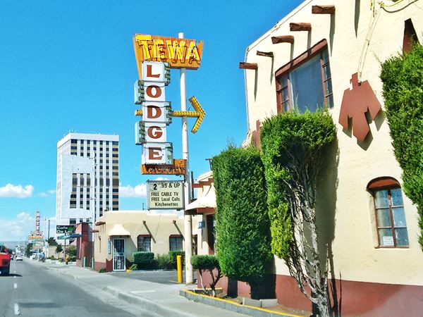
Tewa Lodge in a vintage 1940s postcard
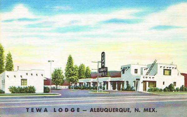
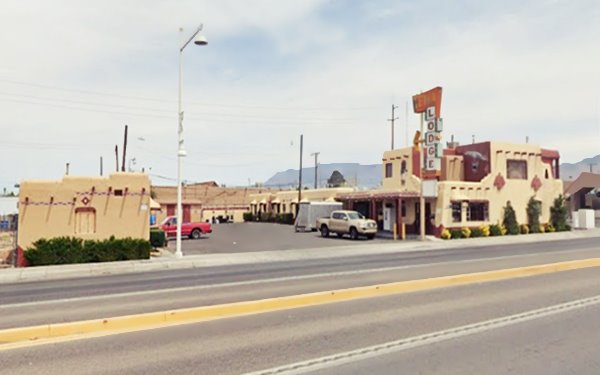
Below we can see that it has barely changed: the sign has moved to the eastern side of the building and upgraded to a classic Route 66 neon sign. A canopy was added at the office:
The Tewa Lodge as it looks today

Mars Motel Court (gone) c.1940s. Source
Click to enlarge
Mars Motel ❌
Just ahead, to your right, at 5615 Central Ave., N.E. was the site of the Mars Motel. It dated back to the 1930s, but was torn down in the mid 1960s. The Cafe Da Lat now stands on the property.
La Vela Lodge
To your right, at 5601 Central Ave NE, Albuquerque on the NE corner with Veta Dr. Surprisingly the old lodge was called "La Vela" which means "The Sail" or "The Candle" in Spanish, but the street next to it is called "Veta Dr." where "Veta" is, in Spanish, a "Vein" as in a mining, or a different tinted region such as the grain in wood.
The motel was built in the late 1930s and it postcard reads "One of Albuqerque's newest Motor Courts. De Luxe Hollywood Beds...Tile showers - All rooms with private bath." Now it is the Lazy Motel, and it has changed substantially, but kept its linear layout.

Present view of the La Vela Motel. St. View.
Click image to enlarge
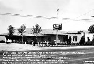
1930s picture of the Route 66 La Vela Motel. Source
Click image to enlarge
On the next block, on the south side of the highway, there were several motels over the course of the years. None have survived. We describe them below.
Nod-A-While Motor Lodge / Silver Spur ❌
At 5508 Central Ave. S.E. to your left. The Nod-A-While opened in the 1940s and had a J-shaped layout, perpendicular to the highway. Single story stucco faced units and an attractive neon sign T-shaped and topped by a cactus. Now it is the parking lot of Pep Boys.
Later it became the Silver Spur Motel with modernized units and a brand new neon sign.

Nod-A-While Lodge (gone) c.1950s. Source
Click to enlarge

Silver Spur motel (gone) c.1950s. Source
Click to enlarge
Honey Dew Drive Inn ❌

Honey Dew Drive Inn (gone) c.1950s. Source
Click to enlarge
On the SE corner with Madeira Dr. SE -now a parking lot- was the now gone Honey Dew Drive Inn. Its postcard mentions its menu: Steaks- Chicken - in Basket, Hamburger - Supreme... Glorified Ham and Eggs." You can see it in this aerial photo from 1959.
The image below looks west along Central Avenue and to the left you can make out the neon signs of the Silver Spur and further away, the Trade Winds; to the right a pancake shop. This is the street view at the same spot today.

Village Inn Pancake House

Village Inn sign over the years. Street view
Click to enlarge
The flat roof building that you can see in the vintage postcard below has been altered but it has retained its original neon sign, now promoting another business. Click on the image to see the sign in the 1960s and now. The red box shows where it is.
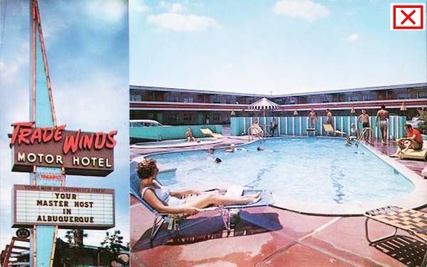
Across the highway, occupying the souther 5400s block was a classic motel, the Trade Winds:
Trade Winds ❌ - Original and Replica Neon Signs
The Trade Winds Motor Inn stood at 5400 Central Ave SE, to your left. It sported a Space Age design and a stunning neon sign. It had "81 ultra modern units, two heated swimming pools - one for kiddies. Dining room and Coffee Shop... free TV and radio. Connecting family suites. King size beds. Room Service. Service Station..."

Calvin and H. B. Horn opened a truck stop here in 1940. They expanded it with a $1 million project into the Space Age Trade Winds. Calvin was a Representative and later a Senator in the state Legislature from 1946 to 1953. The motel was torn down in 2009 (see a 2007 street view when it was the Travelodge.) The Shopping Center was built in 2016.
The Trade Winds Shopping Center signs along Central Ave. pay homage to the original neon sign of the Trade Winds Motor Inn, and an original sign survives until now.
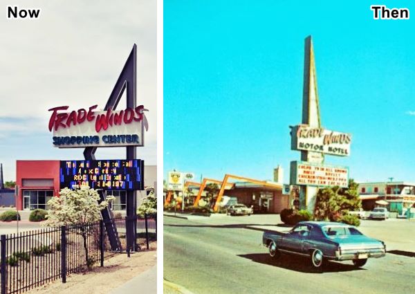
New municipal signs ordinances in 1976 impacted on the sail-shaped sign. It was cut to half its size. Most signs along Central Ave. followed suite, they were replaced by bland rectangular signs.
The original signage of the hotel survived the demolition. See the sign on the SW corner of Madeira Dr. S.E. with Central (2014 image and this 2022 street view.)
The First National Bank Building East
On the north side of Central Ave, at 5301 is the 17 story building designed by Flatow, Moore, Bryan and Fairburn for the First National Bank. It was the tallest building in New Mexico when it opened in 1963 with a height of 212 feet.
American Car Wash
Along the western side of the Trade Winds motel on the SE corner of Central and San Mateo, was a magnificent Googie style car wash, the American. Its Space Age design survives until now, and it is still operating as a car wash. It has a long low building with a flat roof punctuated by large vertical bow-shaped pylons following the motif of the motel. They pierce the roofline and soar above it. A symbol of the optimism of the 1960s when a wash cost ¢94.

American Car Wash 1960s. Source
Click to enlarge
San Mateo Blvd. and Central Ave
There were two motels and a diner on the intersecteion of San Mateo Blvd. and Central Ave. all gone. Below is a view of the crossroads looking west along Central Ave.
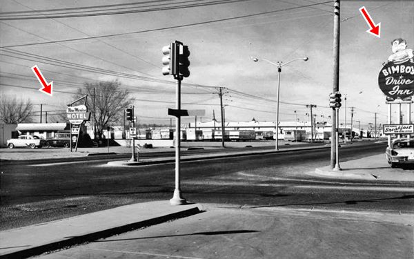
This is the current street view at the same spot.
Cooksey Court, later New Mexico Motel ❌
On the SW corner of Central Ave. and San Mateo Blvd. S.E. was the Cooksey Court, at 5210 Central SE. The red arrow on the left marks the spot. At some time in the 1950s it became the New Mexico motel. It appears in the 1959 aerial photograph of the area, but vanished by 1967. Below are two views of the motel under its different names. They kept the rounded sign until the late 50's when they updated it to a dynamic geometric one with a slanted sharp design as you can see in the image further up.

Cooksey Court 1940s. Source
Click to enlarge

New Mexico Motel c.1950s. Source
Click to enlarge
Iceberg Cafe ❌

Iceberg Cafe (gone) c.1940s. Albuquerque Route 66. Source
Click to enlarge
Opposite the New Mexico Motel, on the NW corner where Walgreens is now located, at 5219 Central Ave. was the now gone Iceberg Cafe. This was its second location along Route 66; originally located in Nob Hill (Read more Iceberg original location) and later it moved to U.S. 85 in Bernalillo.
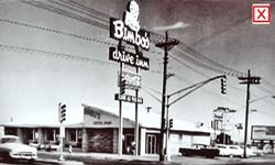
Bimbo's Drive In - Fireside Inn ❌
In the early 1950s the premises were occupied by Bimbo's Drive'in, a coffee shop home of the Delicious Double Decker Hamburger.
It was owned by John Marchiando it was almost the only restaurant in town that stayed open until 2 AM.
In the 1960s it became the Fireside Inn, a topless night club with go-go dancers, also owned by Marchiando and his wife, a former Las Vegas showgirl; you can see it in this aerial photo from 1967. Click on the still to see a video of the Fireside Inn. It seems to be part of a movie or TV series from the 1970s.
Bimbo's Drive In. Source
Click to enlarge

Fireside Inn, video. Source
Click to see video
Anchor Inn / Bar-X Motel ❌
Also on the north side of the highway, next to Bimbo's, across Truman St NE, where Wecks is now located at 5115 Central N.E., was the Anchor Inn, that later became the X-Bar motel and (at 5127) Jennigns and Johnson Realtors offices. The postcards below show both versions of the same motel, under its different names. Notice the anchor shaped sign of the Anchor Lodge.

Achor Lodge motel 1940s. Source
Click to enlarge

Bar-X motel 1950s. Source
Click to enlarge
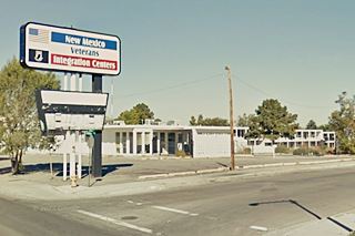
Desert Sands Motel and its Neon Sign ❌
On the next block, to your left is a brand new apartment complex with a long seven-story building facing Route 66 (5000 Central Ave SE).
This was the site of the "Desert Sands Motor Hotel", built in 1953 with a "U" shaped layout with a swimming pool and its office on the western side of the central courtyard.
The motel had been the location in the Oscar-winning movie by the Cohen brothers, "No Country for Old Men" (2007) trailer video.
It was still operating as a motel when a fire broke out on May 24, 2016. The blaze burned the motel and injured two; this is a Street view from 2016, after the blaze.
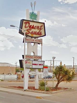
Desert Sands Neon Sign

How the Desert Sands neon sign evolved over the years. A. Whittall. Sources
Click to enlarge
Click on the thumbnail to see how its neon sign evolved over the years from the 1950s to 2003 (the picture on the right, by John Margolies. It began as an inverted trapezoid with horizontal bars spelling "Desert Sands - Motor Hotel" with an upper slanted decoration (gone in the lower image), to a completely new sign in the mid 1960s: tall H-shaped with multiple boxes along it topped by the name and a yucca.
Although the building was razed shortly after the fire its neon sign remained in place until March 2018 when it was removed after being purchased by a collector.
The final section of US66 in Eastern Albuquerque
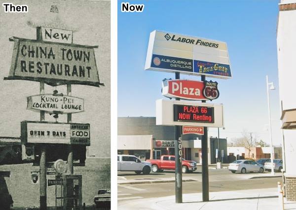
New Chinatown Restaurant neon sign
Opposite the Desert Sands, at 5001 Central Ave. on its NE corner with Jackson, was the New Chinatown restaurant. Its original neon sign has survived. It offered "The finest Chinese dining rooms and cocktail lounge in the Southwest." It later became the Fuji Yama (see its 2011 St. view) and was torn down in the around 2014. Below is a Then and Now set of images of the surviving sign:
Coronado Court ❌

Coronado Court c.1940 Source
Click to enlarge
At 4907 Central Ave, where the Bank of Albuquerque is now located. It was torn down in the mid 1960s.
Hiland Theater
To your left, on the next block, facing the south side of the highway at 4804 Central Ave SE.
Hiland is one of four classic theaters on Route 66 in Albuquerque. It opened on April 20, 1950 and could seat 1,188 spectators. It included a car park for 350 cars. It closed in 1995. And was leased to the National Dance Institute of New Mexico (NDI). It has since been neatly restored and is a theater venue.

The Hiland Theater 1950s. Credits. Click to enlarge
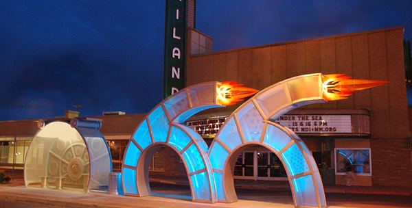
Reels and Wheels Route 66 artwork
An art project was planned in 2013. It was to be installed in front of the Hiland and commemorate Route 66; itt also had to contemplate its use as a bus shelter. The county Arts Board selected the work of Howard Meehan that includes a movie reel paying homage to the Hiland, and two "Red Hot Wheels" designed to look like sixes with flames shooting out of their tips. Solar panels power the LED lights inside the hollow "66". Pictured below:
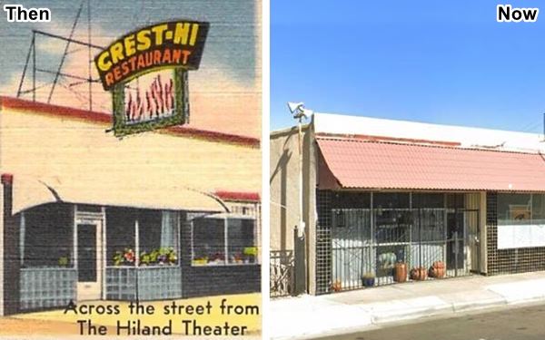
Crest-Hi Restaurant
Opposite the Hiland, at 4805 E. Central, its postcard read "Crest-Hi Restaurant, good food -- Always... On highway 66... THE BEST CUPPA COFFEE ON HIGHWAY 66." It offered "Complete Dining Service, Moderate Prices, breakfast, Luncheon, Dinner, Sandwiches," and delicious steaks, chicken and sea foods plus "Plenty of Parking Space." Below is a then and now set of images:
Zia Motor Lodge Neon Sign
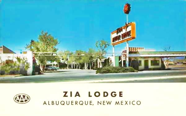
Two blocks west, to your right, at 4611 Central Ave NE was the classic Zia motor lodge. On the NW corner of Central and Madison St. All that remains is the old neon sign, a legacy sign on Route 66:
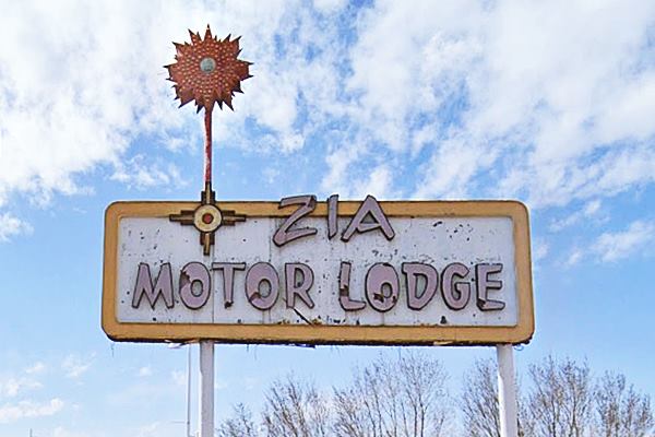
The Zia Motor Lodge dates back to 1940, and has gone; all that remains of the family operated motel is its original neon sign. A fire razed it in 2005. It was mentioned by Rittenhouse in his 1946 Route 66 Guidebook. The back of the postcard shown below tells us that it had "Sun Deck... Patio... Located in the Highland Shopping Center... One Block Walking distance to Theatre and good Restaurants. Mr. and Mrs. Henry Martin, Owners and Managers."
Zia
The Zia are a Native American nation also known as Ts'íiy'am'é. Their homeland is located near Zia Pueblo NM. Their sun symbol is featured on New Mexico's state flag.
Gas Station and Auto Repair Shop
On the next corner (Central and Jefferson) there are two 1950s buildings, one is a gas station from 1954, on the south (left) side of Central Ave. (St. view) it was an El Paso in the 1970s, the other an auto repair shop that opened in 1959 with a modern design including a slanting roof and plate glass facade (St. view), on the north (right) side of the highway.
Ambassador Lodge - Ramada Inn ❌
This motel stood at 4501 East Central Avenue on the NE corner with Adams St. later in the 1960s-70s it became the Ramada Inn, below are pictures of both:

Ambassador Lodge (gone) c.1940s. Source
Click to enlarge

Ramada Inn (gone) c.1970. Source
Click to enlarge
The Ramada sign's brick column on the eastern side of the property is still there (street view, and there is also a sign on the western side of the property when it was the American Inn as you can see in the 2007 street view before it was torn down.
Across the street is Loyola's Family Restaurant that Loyola Baca opened more than 30 years ago by Loyola Baca. It has been the location of several movies and TV series: Breaking Bad, In Plain Sight and Terminator: The Sarah Connor Chronicles, this is its street view.
El Sombrero ❌

El Sombrero Restaurant (gone) c.1940s. Source
Click to enlarge
At 4415 Central Ave NE, to your right, El Sombrero (Spanish for hat, in this case is the broad rimmed felt hat used by Mexicans in the Southwest) opened in 1949 it was a restaurant featuring Mexican food. It had a giant sombrero on its roof and the cars parked radially around its circular curb to be served. It closed in 1958 and was razed. See it in this 1951 aerial picture. There was a second restaurant with the same name at 1221 West Central Ave (St. view).
There is a Gateway Arch here spanning Central Avenue, there is another on the western entrance to ABQ.
At the next corner, at the intersection of Washington St. and Central Avenue on the 4300 block, you enter Nob Hill District:
End of this segment of your Road Trip through East ABQ
Read all about Nob Hill's Route 66 attractions in our Next Page.
The Route 66 Attractions in Albuquerque
Albuquerque is, after St. Louis and Oklahoma City, the third largest city between its two endpoint megacities, Chicago and Los Angeles. However, it has preserved far more classic landmarks along Route 66 than any of the other cities.
We have split this segment of your Route 66 road trip across Albuquerque into six separate webpages, to be able to mention all of them. They are, from east to west, the following:
- Main Page: Albuquerqe overview, hotels, history, maps
- Page 1. Eastern Albuquerque
- Page 2. Nob Hill
- Page 3. Downtown
- Page 4. Colonial Town & Western Albuquerque
- Page 5. 4th St. Route 66 - 1926-37 Sights
Continue your Road Trip westwards beyond Albuquerque
After covering each of our five webpages you will have reached western Albuquerque, the endpoint of your Route 66 acreoss the city. You can continue your Route 66 road trip by heading west into the next town, Suwanee NM on the 1937-85 alignment or Isleta on the 1926-37 alignment.
Sponsored Content

>> Book your Hotel in Albuquerque

Credits
Banner image: Hackberry General Store, Hackberry, Arizona by Perla Eichenblat
Jack DeVere Rittenhouse, (1946). A Guide Book to Highway 66.
Sources of the postcards in the Desert Sands neon signs image: source 1, source 2, source 3, and source 4.


