Route 66 in Gray Summit
Index to this page
- About Gray Summit
- Weather
- Hotels close to Gray Summit
- Map of US 66
- What to see and do in Gray Summit
About Gray Summit Missouri
Facts, Trivia and useful information
Elevation: 633 ft (183 m). Population 2,552 (2024).
Time zone: Central (CST): UTC minus 6 hours. Summer (DST) CDT (UTC-5).
Gray Summit is a village on the Original 1926 to 1932 alignment in northeastern Franklin County, in central-eastern Missouri.
Gardenway Inn sign, Route 66 in Gray Summit Missouri
History of Gray Summit
For a general history of the area (Franklin County) visit our St. Clair History post. German immigrants settled in the area in the 1830s as farmers. When the Missouri Pacific Railroad planned its line from St. Louis to Kansas City it chose the crest of the divide between the Meramec and Missouri Rivers. Knowing this, Daniel Gray built in 1845 a hotel at the highest point along the future line.
At this spot known as Point L'Abaddie, the railroad built a siding in 1853. The name Labadie was given to a station 3 mi. west, while the hotel stop was called "Summit". However, there already was a town in Missouri with that name so it was changed to "Gray Summit".
The Name: Gray Summit
Daniel Gray opened a hotel in this spot in 1845, at the highest point of the railroad between the state capital and Saint Louis, the "summit", hence "Gray Summit".
At that time it was already the crossroads of the state's oldest highways: the "Wagon Road" and the "State Road to Jefferson City". It grew as a farming community on the main road linking St. Louis with the state capital, Jefferson City (now MO-100 and US-50) and in 1926 the newly US highway 66 and 50 were both aligned through the community. In the early 1950s Route 66 was too congested and, all through Missouri it was moved out of the towns and cities, bypassing them, this also happened to Gray Summit.

Where to Lodge in Gray Summit, Missouri
Accommodation and hotels near Gray Summit
>> Book your Hotel in
More Lodging close Gray Summit along Route 66
There are several hotels in the area close to this town. Alternatively you can also find your accommodation along Route 66 in the neighboring towns and cities in Missouri. We list them below (from east to west):
On Route 66's Main alignment in MO
Eastwards
Westwards
- Hotels in Kansas
- Baxter Springs KS
- Galena KS
- Riverton KS
- Hotels in Oklahoma
- Miami OK
>> Check out the nearby RV campground in neighboring Villa Ridge
Weather in Gray Summit

Location of Gray Summit on U.S. Hwy. 66
Gray Summit has well defined seasons, because it combines wet continental and humid subtropical climates. Summers are hot and humid while winters are cold. Spring is wet and may have extreme weather (tornados, thunderstorms and even winter storms). Fall is sunny and less humid, with mild weather.
The winter (Jan), the average high is around 39°F (4°C) and the aveage low is a freezing 21.8°F (-5.7°C). The summer (Jul) average high is 88°F (31°C) with an average low of 68°F (20°C). Rainfall averages 43 in. (1.092 mm) yearly and takes place during some 90 days each year. There are around 205 sunny days yearly. Snowfall is around 17.8 in. (45 cm), which falls from November to April.
Tornado risk
Gray Summit is located in Missouri's "Tornado Alley" and Franklin County is struck by some 7 tornados every year. Tornado Risk: read more about Tornado Risk along Route66.
Map of Route 66 in Gray Summit
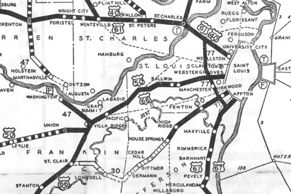
The map below shows Grays Summit on Route 66; the dark black line indicates that it was paved at that time (1931). The following year it would be replaced by the new alignment running through Eureka and Pacific.
Map 1931 showing US66 into St. Louis
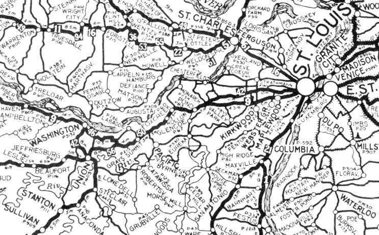
1924 Auto Trails Map. Source.
Click image to enlarge
The 1926 to 1932 Route 66 followed the "State Road to Jefferson City" built in the 1840; nowadays it became MO-100 and US-50. It linked St. Louis with the state capital in Jefferson City.
The thumbnail map (click on it to enlarge) shows the "Auto Trails" in this region in 1924. These trails were roads that cars could drive along relatively safely in the days when mud, pot holes and river fords complicated driving.
The trails had names: The one followed by Roue 66 in 1926 was marked "50" (Ozark Trails) running from St. Louis through Gray Summit and St. Clair. The later US 66 was built in 1932 through Pacific and Eureka into St. Louis.
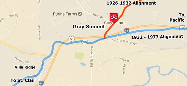
The image above shows, in Orange the 1926 to 1932 alignment of Route 66 from St. Louis to Gray Summit (see alignment map).
Pale Blue, west of Gray Summit marks the 1926 - 1953 US 66, and east, it is the 1932 to 1953 Route 66 that bypassed older one (see alignment map).
The Route 66 alignment in Gray Summit
Visit our pages with old maps and plenty of information about US 66's alignments.
- Rolla to Springfield (next)
- Gray Summit to Rolla (in Gray Summit)
- Route 66 in St. Louis (previous)
Route 66 Sights in Gray Summit
Landmarks and Places to See
Sponsored Content
Historic context, the classic Route 66 in Gray Summit
The WPA travel guide "Missouri, a guide to the "Show Me" state" published in 1941 tells us its history and informs it had 215 residents; it mentions the 540 acre Ralston Purina Co. Experimental farm, one mile away and the Shaw Nature Reserve or Arboretum.
Jack DeVere Rittenhouse in his "A Guide Book to Highway 66" published in 1946 wrote:
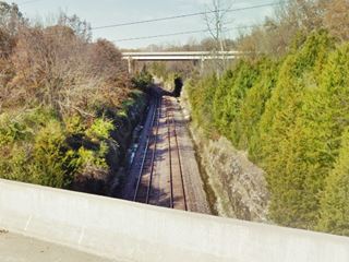
The village of Gray Summit is off to the right here, and US 66 crosses a deep cut through which a railroad runs. Watch for the tunnel (R[ight]) Rittenhouse (1946)
There was a truck weighing station 1 mi. west, now gone.
Sights in Gray Summit
We will tour Gray Summit driving westwards along the newer (1932-50s) Route 66 alignment, coming from Pacific. The first stop on this leg of your Route 66 road passes by the site of a long gone motel:
Motel Normandy Site
2.5 miles west of Pacific, this gable roof motel was ran by the O'Hanlons. It had several gabled-roof cabins painted white. You can still see them with their green roofs. The place closed when US 66 definitively bypassed them in the mid 1960s.
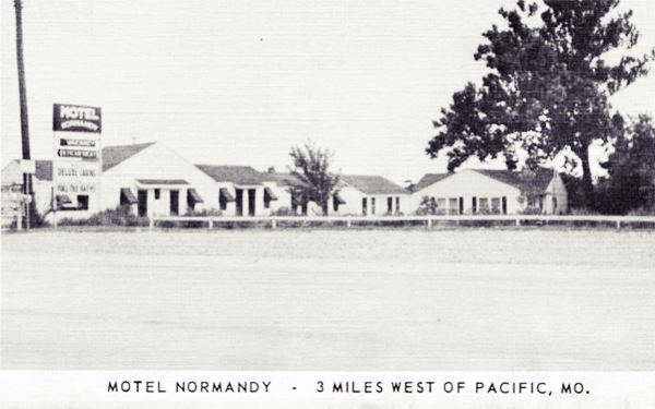
It was located around the 3200 block of W. Osage St., close to where B & B Concrete is now located, but it was torn down and nothing remains of it.
Site of Crest Restaurant
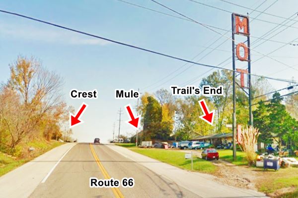
Just ahead, on the "crest" of the hill, to your right, where U-Haul is no located, was the "Crest Restaurant and Cabins" and service station ran by Ed and Dell Moore. They also sold gasoline. Nothing remains of it either, except for the concrete curbs marking the entrance to the site.
You can see it in this aerial photo taken in 1945, above Route 66 that runs across the image.
Mule Trading Post
The Mule Trading Post that is now in Rolla MO, originally stood on Route 66 here, in Gray Summit.
Frank Ebling opened the original "Mule Trading Post" back in 1946, see its picture below, and according to Therissa Schlemper it "was located about across the highway from the Crest".
When Route 66 was replaced by I-44 and bypassed his store, Frank moved west to Rolla in 1957 and opened a new store on the frontage road of I-44 ⁄ Route 66 figuring it couldn't be bypassed.
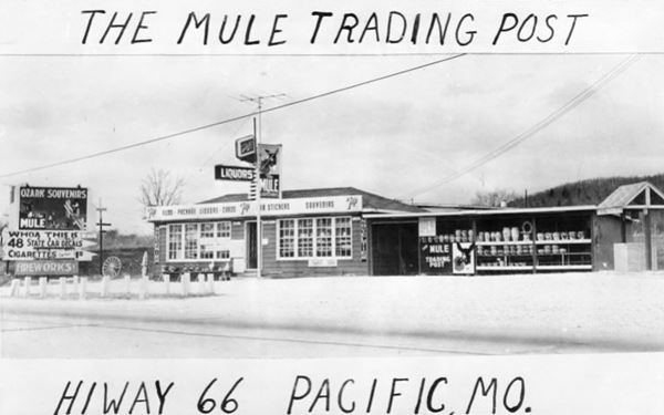
The postcard says "Pacific" as it is the nearest town on the 1940s Route 66, 3 miles away, and helped potential customers get their bearings, but it is really part of Gray Summit.
The image below, looking eastwards along Route 66 shows its approximate location on the hilltop opposite the "Crest":
Trail’s End motel
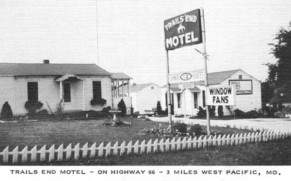
Ahead, passing the crest, to your left is the old "Trail's End Motel" at 3218 W Osage St., Gray Summit. It faces the highway with a long and narrow gable roof building and more units along the street on the western side of the motel.
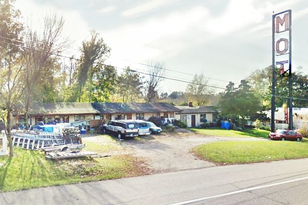
It opened after 1945 (it does not appear in the 1945 aerial photo of the area); and was owned by Willard Haley who later bought the "Motel 44". Its postcard announced "Window Fans" and placed it 3 mi. west of Pacific. Below is a then and now sequence; the 1940s photograph shows the western tip of the motel, with the units along Hardeman St to the right; you can see it in this street view of these cabins and this 1992 aerial photo (to the right).
When it was bypassed by I-44 in 1965 a new tall vertical sign was erected to catch the eyes of those driving along the Freeway, of the original word "MOTEL" only the letters "MOT" remain.
Former Trail’s End Motel, Route 66 in Gray Summit Missouri
Deep Cut: Route 66 and railroad
Just ahead the highway crosses the Union Pacific Railroad; it is the "deep cut through which a railroad runs. Watch for the tunnel" pointed out by Rittenhouse in 1946. The cut is still there, but the original lost arch bridge (open-Spandrel Arch) bridge built by Gaines Bros. in 1932 has gone: it was replaced in 1994 by a steel bridge.

Railroad tunnel in Gray Summit. Source
Railroad Tunnel
The tunnel is 2,000 ft. to the right. The Missouri Pacific Railroad followed a steep climb to the "summit" at Gray Summit, demanding powerful locomotives and lower speeds due to the climb. In 1929 the railway decided to reduce the gradient and improve circulation along this line, which was their busiest one, by building a tunnel.
They also added a second track next to the original one. It is still in use (now the railroad is the Union Pacific Railroad Co.).
The tunnel passes under the town and carries two tracks. It is about 1,500 ft. long. There is another tunnel further west, at Labadie.
Old and New alignments Meet
Gardenway Neon Signs
At the freeway's Exit 253 is the junction of the "old" and "new" Route 66 alignments; they are marked with Orange (1926-32 US66) and Pale Blue (1932-50S) lines in the Map of US 66 further up.
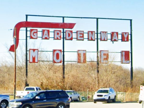
Straight ahead you will see a large "Gardenway Motel" neon Sign, pictured at the top of this page currently says "GARDENWAY - MOTEL" in white letters inside red boxes and has a large red arrow showing the way to the motel. But at one time, there was another text above the motel's; it read "DIAMONDS - RESTAURANT" in black letters in white boxes and beneath. This was the advertisment of the famous "Diamonds Resaurant" at its second and final location.
Until quite recently, there was another sign to your left, on the south side of Route 66, facing the overpass at the intersection. It has been removed, but you can see it below (2018 view):
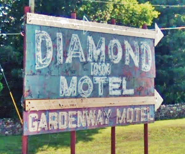
Into Gray Summit along 1926-32 Route 66
Motel 44

Motel 44 in 1971, Gray Summit. Source
Take a right along MO-100 into Gray Summit, this was the original Route 66 alignment until 1932. On the north side of the freeway, to your left (street view) once stood the "Motel 44", with "TV - FM Music - Electric Heat... Mr. & Mrs. Willard Haley - Owners", Haley had also owned the Trail's End. The place has gone and was filled in; nothing remains of the motel.
Head west, ahead to your left is the "Roadhouse 100", a friendly local bikers bar, food & beer.
Nothing remains of the original Route 66 buildings in the town, but you can take a left along Highway MM to visit a local sight:
Purina Farms
At 200 Checkerboard Dr, Gray Summit, Map with Directions.
Just 1.4 mi. west along Hwy MM. If you like dog shows and competitions, this is a place to visit. It has farm animals, restaurant, a great stop for children. More information at their website.
Turn back and retrace your steps to the junction of the old and new alignments, turn right and head west.
The Diamonds - second and final location

The Diamonds in the 1970s Gray Summit.
Click image to enlarge.
Source
Ahead, at 2875 MO-100 (Historic Route 66) to your right is the site of The Diamonds'e sprawling restaurant and gas station, now gone, followed by The Diamonds Inn motel (still standing). The thumbnail image shows an aerial view looking north east towards Pacific, click on it to see full size image.
The First "Diamonds" Site: Villa Ridge
The original Diamonds restaurant, was located about two miles west, in Villa Ridge. Built and owned by Spencer Groff in 1927. Louis Eckelkamp and Nobel Key former employees partnered with Groff in 1935 and bought him out in 1938. The place burned down in 1948 and was rebuilt in a Streamline Moderne style. The site also included a motel with 25 cabins and a pool. Read about this First Diamonds in our Villa Ridge page.

"The Diamonds" in Gray Summit now and in the 1970s.
Click for street view
see postcard
The Diamonds moved to Gray Summit
However, the 1967 realignment of Route 66 when I-44 was completed, cut him off from his customers. Eckelkamp closed his restaurant and moved it to a new location on the freeway in Gray Summit.
The image shows what is left of the original building, in the upper part, the remains of two signs, below an early 1970's postcard showing those same signs, the one with the word "Texaco" is now empty, but the one with "Sinclair" on it now says "Diamond Inn".
It was closed from 1969 to 1972 when it reopened at this better location on the south side of Exit 253. It had a motel and three service stations selling Sinclair, Texaco and Sunoco brands. Eckelkamp kept the original sign thath he had brought from the old location. The place remained open until the mid 1990s. Then it closed and was later demolished.
The dining area called itself the "World's Largest Roadside Restaurant", and boasted it served over 1,000,000 customers a year. It also had a motel next door, the Diamond Inn. The motel is still there, but closed.
Eckelkamp also owned the neighboring "Gardenway Motel" so he added his motel to the "Diamond's" sign.
The Shaw Nature Reserve
Across the road at 307 Pinetum Loop Rd. is the The Shaw Nature Reserve Visitor Center
The Reserve is a division of the Missouri Botanical Garden, spanning 2,400 acres of natural Ozark Border landscape; it also has 1.5 miles of Meramec River frontage. It dates back to 1925 it was named after Henry Shaw, founder of the Missouri Botanical Gardens. It was established to protect the plant collection from St. Louis 1920's smog. It is an outdoor spot for recreation (with 13 mi. of hiking trails), research and nature reserve. More information at their website.
The Henry Shaw Gardenway
In 1935, a portion of Route 66 from the St. Louis city limits westwards to the arboretum in Gray Summit was dedicated as the Henry Shaw Gardenway. Not much remains of it. It was a typical beautification program of the 1930s Depression days: it was planted in native flowers and shrubs, with hawthorn, redbud, and dogwood trees together with the local hickory, oak, and pines. Only the Jensen Point overlook in Pacific and a bus stop shelter that used to be at Allenton and now has been moved to the Shaw Reserve, and is pictured below.
Allenton Road bus shelter
Old Allenton Bus Shelter, Route 66, Missouri
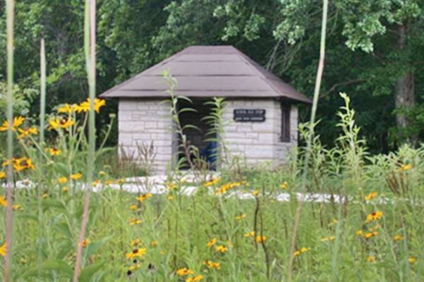
The one-room limestone faced bus shelter built in 1939 was once located on Route 66 and its SE corner with Allenton Rd. It was moved to the Shaw Reserve, 1 mi. from the visitor center (map with directions).
Now head west, passing by the site of the now gone "Truck Weighing Station" mentioned by Rittenhouse on the right sdie of the highway opposite the Reserve. Ahead, to your left is the old Cozy Dine site:
Cozy Dine (Gone)
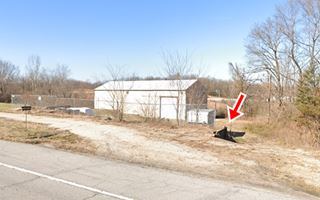
We located it because there was a benchmark here "near NW. corner of Shaw's Garden... on SE corner of concrete porch of Cozy Dine Cafe; chiseled square" the benchmark appears marked with an "X" on the USGS maps so it was on the north side of US66 facing Robertsville Rd. The "Then and Now" images show that the retaining wall has survived (red arrow) and the curbs on the highway.
It was owned by Clifford Weirich from 1929 to 49; then it was ran by H. Goebel (1949-65) and finally by the Kreienkamps until it closed in 1969. It was a cafe and Shell gas station.
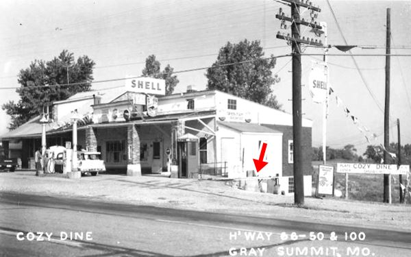
Gardenway Motel
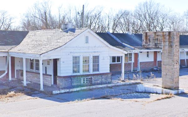
Across the highway, just ahead, to your left at 581 Highway 100 East is the classic "Gardenway Motel".
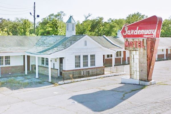
Same view nowadays, cupola and neon sign have gone, a concrete pillar stands where the sign was:

Gardenway motel neon sign, Gray Summit Route 66
Louis Eckelkamp built part of the present motel complex a short distance from his family's home in 1945; the second part was constructed in 1953. It consists of two linear units parallel to Old US 66 one behind the other. It had 41 units. It was built in Georgian Revival Style popular at that time, its name is a reference to the neighboring "Henry Shaw Gardenway". He operated it with his wife Martha and when US 66 was bypassed in the 1960s, he added the sign on the hill (mentioned further up)
Neon Sign
It had a great neon sign with a red arrow mounted on a concrete column faced with stone and glass-brick.
The sign taken down in 2019 for its own protection, and according to a post by the Route 66 Association of Missouri: "the sign is safe in storage."
Continue west and visit the final landmark in this leg of your road trip, an classic stop on Route 66.
33 Mile Post
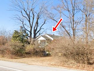
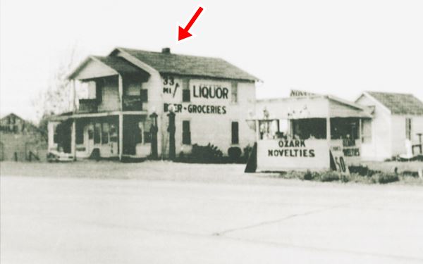
To your right, hidden by the trees are some buildings. The two floor gable roof structure is what used to be the main office, grocery store, tavern, gas station office, and home of the Hurts. Virgil "Bird" Hurt and his wife Marie moved here from St. Clair in 1933.
It has survived as you can see (red arrow) in the "Then and Now" images.
There had been a tavern here named "33 Mile Post" it was named as a stop on the "Post Road", that was used by the U.S. Post Office to deliver mail;
the Wire Road from St. Louis to Springfield served as a Post Road.
It had two cabins and sold Skelly gas at first, and later White Rose Gasoline (of the National Refining Company). The family sold plaster lawn ornaments in a stall named "Ozark Novelties". Next door is the Bush Creek Cemetery.
This is the end of your tour through Gray Summit Missouri, Continue your Route 66 Road Trip westwards to visit your next stop driving towards Villa Ridge.

Some sponsored content
> > Book your Hotel in Lebanon

Credits
Banner image: Hackberry General Store, Hackberry, Arizona by Perla Eichenblat
Architectural - Historic Survey of Route 66 in Missouri and Detailed Survey, Maura Johnson. 1993
Jack DeVere Rittenhouse, (1946). A Guide Book to Highway 66


