Route 66 in Willowbrook IL
Index to this page
About Willowbrook IL
Facts, Information and trivia
Elevation: Elevation 696 feet (212 m). Population 9,056 (2022).
Time zone: Central (CST): UTC minus 6 hours. Summer (DST) CDT (UTC-5).
The Village of Willowbrook is located in DuPage County, in NE Illinois.
History of Willowbrook
Visit our History of Chicago section in our Chicago webpage for an early history of the area.
When Route 66 was created in 1926, and until around 1960, this area was an open countryside with fields and very few buildings. It wasn't an urban or suburban area. Route 66 was aligned along a new alignment that was specially built for it at that time, west of Lyons roughly three miles north of the Des Plaines River.
Des Plaines River
The river is 133 miles (214 km) long and has a discharge flow of 535 cubic feet per second (15 m3 ⁄ s). It runs from southern Wisconsin to western Chicago and then turns west and south, meeting the Kankakee River to form the Illinois River, which in turn flows into the Mississippi River.
Its water reaches the Gulf of Mexico!
This river was used as a trading route by the locan Indians and after the 1600s the French used it too. They named it as La Rivière des Plaines (River of the Plane Trees) after the trees along it. They used the word "Plaine" at to name the American sycamore and the red maple both of which resembled the European plane tree.
A Canal was built in the 1840s along it, and many dams have been built to regulate its flow. It meets the Sanitary and Ship Canal in Lockport before flowing through Joliet, both towns are located on Route 66 south of Willowbrook.
DuPage County was established in 1839 and was named after the DuPage River, which in turn was named for a French fur trapper who settled there before 1800.
Hinsdale
This area in 1926 was part of the town of Hinsdale running about 4 miles south of it. Hinsdale was born in 1863 on the tracks of the Chicago, Burlington & Quincy Railroad, on land purchased by William Robbins who knew the railroad's projected right of way. He platted the town in 1865, and it incorporated in 1873.
As the region south of Hinsdale was open and flat, an airfield was built here around 1938, linked to Chicago by Route 66. It was around that time that Irv Kolarik opened his famous Chicken Basket Restaurant across the road from the airport to cater to those coming and going from it, and also locals and Route 66 travelers.
Route 66 became a four-lane highway in the late 1940s, and in 1960 with the freeway (I-55) being built across the district Chicago's suburban sprawl reached the area and it was rapidly built up. The village of Willowbrook created in the southern reaches of Hinsdale, in its Ridgemoor subdivision. It was incorporated as a village in 1960.
The name: Willowbrook
The village was named by Anton Borse, then president of the homeowners' association, the story goes that Borse had to decide the name on the incorporation documents and looking out of the window he saw wome willows growing next to a creek. The name came to him: "Willowbrook".

Accommodation in Willowbrook
> > Book your hotel in Willowbrook
Find More Accommodation near Willowbrook along Route 66
Below you will find a list of some of the towns along Route 66 east and west of this town; click on any of the links to find your accommodation in these towns (shown from east to west):
Along Route 66 in IL
- Hotels in Illinois
- Route 66 Starting point ▸ Chicago
- Lockport
- Willowbrook
- Bolingbrook
- Plainfield
- Romeoville
- Joliet
- Wilmington
- Dwight
- Pontiac
- Chenoa
- Normal
- Bloomington
- Atlanta
- Lincoln
- Springfield
- Raymond
- Litchfield
- Staunton
- Williamson
- Hamel
- Edwardsville
- Collinsville
- Troy
- Glen Carbon
- Pontoon Beach
- Granite City
- East St. Louis
West in Missouri
- Hotels in Missouri
- Florissant MO
- Bridgeton MO
- St. Louis MO
- Kirkwood MO
>> See the RV campgrounds in Chicago or in Joliet and Braidwood
The Weather in Willowbrook
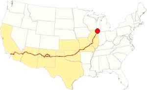
Map showing the location of Willowbrook, Illinois on U.S. 66
Willowbrook's climate is humid and continental; with very well defined seasons: Spring is cool and wet; summer is hot and frequently humid. Winter is cold and has on average 28 inches (71 cm) of snow, while Fall is very mild.
Temperatures: Average high in Jan (winter) 31°F (-0.3°C) and the average low is 17°F (-8.6°C). Average high in Jul (summer) 84°F (29°C), with an average low of 64°F (17.7°C).
Rain averages 36.82 inch (936 mm) per year and it is highest with 3 to 4.3 inch monthly (78 and 110 mm) begins in Apr. The rest of the year has an average of 1.7 in. (28 mm) per month.
Snow: In Willowbrook you can expect snow from October to April, however usually the first snow falls in Nov. and the last happens in April (usually one quarter inch -8 mm).
Tornado Risk
The region around Willowbrook experiences about 4 tornados per year.
Tornado Risk: read more about Tornado Risk on US 66.
The Maps of Route 66 in Willowbrook
>> Our Custom map shows the different US 66 alignments in Willowbrook.
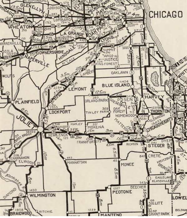
The map below was published in 1924, two years before Route 66 was created, it shows the different Auto Trails in the area around Chicago. These trails were roads that were fit to be driven by cars (not necessarily paved, but with a good hard surface). Those marked with numbers in black boxes are named trails, for instance "34" was the "Lincoln Highway" and you can see it running into Joliet and through Plainfield. The numbers inside white circles were the state highways: the "4" inside a white circle is State Highway 4. It runs through Lemont and Lockport to Joliet to the south and east of the Des Plaines River, it would be the first alignment of Route 66 in 1926. And we marked it with a bordeaux line in our custom map
Route 66 and Willowbrook
When Route 66 was created in 1926 it didn't pass through what is now Willobrook. It ran further south from 1926 to 1928 from Lyons to Joliet through Lockport, along the southern and eastern side of the Des Plaines River and the Illinois & Michigan Canal.

1927 Chicagoland map. Source

1928 Illinois State roadmap (see State Hwy 4A). Source
The 1927 and 1928 maps above don't show any towns west of Lyons on the future alignment of Route 66. To the north lay Hinsdale and Lagrange and nothing else.
The highway was realigned in 1928 along the western side of both waterways, through Romeoville (violet and pale blue lines in our custom map).
Route 66 Realignment (1940 to 1956)
But, in 1939 a straighter course was built for Route 66 and this one went into Plainfield along former State Highway 126 (red line in our custom map). Running from Welco Corners to Plainfield.
It then turned sharply and continued westbound with a completely new aligngment in a straight line towards Braidwood (yellow line in our custom map)
This completely new highway was designated as U.S. Highway 66 and the "old" roadway was designated as Alt US 66.
Alt US 66 from 1940 to 1967
The original alingment of Route 66 created in 1926 between Gardner and Romeoville, via Joliet therefore became the Alternate U.S. 66 highway and remained in use until it was delisted in 1967. The Alternate 66 alignment was eliminated in February 1967 and replaced by Illinois State Highway 53 from Welco Corners to Gardner.1
US 66 from 1956 to 1977

1969 Illinois State Roadmap. Source
Click map to enlarge
The state highway map of 1959 shows changes: US 66 south of its fork with ALT 66 is an "Expressway" with "highway separation" (overpasses and limited access). It has also bypassed Plainfield, leaving the old 1940-58 US 66 aligmnent to become IL-126 and IL-59.
During the 60's, the urban sprawl from Hinsdale is growing south along I-294. The 1969 state highway map (pictured) has I-55 and US-66 running together until the exchange with I-294, where they split, I-55 running further south and US-66 north.
Route 66 is a Historic highway and has also been designated as a National Scenic Byway and an All-American Road in the state of Illinois.
The old Route 66 is a Historic highway and has also been designated as a National Scenic Byway and an All-American Road in the state of Illinois.
The Route 66 alignments near Willowbrook
Description and interactive maps of US 66.
- Pontiac to Springfield (next)
- Chicago to Pontiac (Willowbrook's)

Willowbrook's Route 66 Landmarks and Attractions
Your Route 66 Road Trip in town
US 66 in Willowbrook: historic context
There is no reference to Willowbrook in the "Guide Book to Highway 66" published by Jack DeVere Rittenhouse in 1946, he begins his detailed description in Plainfield. Also, in those days what is now Willowbrook was just open fields.
The WPA's 1939 guide to Illinois describes a tour along Route 66 ("Tour 17"), but it only mentions Chicago, Cicero, Berwyn, Lyons. Lyonsville (what is now Indian Head Park) with two golf courses marks the western limit of built-up area (Wolf Rd. and Route 66) just east of where modern I-294 and I-55 cross each other.
The WPA writes: "Lyonsville marks the eastern limit of the flat lake plain of ancient Lake Chicago, the forerunner of Lake Michigan. Westward lies the faintly rolling, wooded Valparaiso Moraine..." Its next entry is the state prison at Stateville, just north of Joliet. So it has nothing to say of any attractions between Lyonsville and the prison along Route 66.
Below we will describe the highway and its sights driving westwards from neighboring Countryside. The exchange between I-294 and I-55 have disturbed the original roadway. Here, after crossing Flagg Creek, you enter Burr Ridge.
Burr Ridge
Elevation 702 ft (214 m), pop. 11,192 (2020).
The International Harvester Co. opened an experimental farm here in 1917 to test their "Farmall" multi-purpose tractor, the first in the world. That same year Cook County also established the Bridewell Prison Farm. In 1947 a developer converted a former pig farm into a suburban community that incorporated in 1956 as the village of Harvester. Another development on the Burr Ridge dairy farm became Burr Ridge Estates. In 1961 both communities merged incorporating as Burr Ridge.
The modern North Frontage Rd. follows the original Route 66's course towards the cloverleaf exchange at County Line Rd. but it is cut off from the Old Route 66 that merges into I-55 here.
There are no remaining classic landmarks on the Frontage Rd. here but there is a modern one at Harvester Park in Burr Ridge. Take the course shown in this map with directions to access the North Frontage Road and follow its course to visit all the sights in this area.
Harvester Park's Route 66 Themed Playground
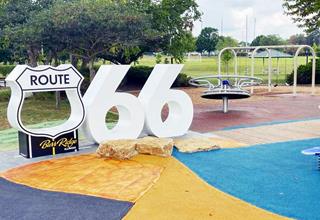
Burr Ridge Selfie Stop at Harvester Park. Source
Located at 15W400 Harvester Drive, there is a playground with children´'s play equipment designed to look like popular Route 66 roadside stops including Catoosa's Blue Whale and the Amarillo Cadillac Ranch. It also has a selfie stop with a Route 66 shield and a large sized sixty-six great for a photo opportunity.
It is part of the 2026 celebration of the Route 66 Centennial (1926-2026) (see picture). It is one of many along the Mother Road sponsored by the Heritage Corridor Bueau using a $1.5 million grant from IL DCEO designed to enhance sites along Route 66 ahead of its Centennial (1926-2026). You can find them in Joliet, Willowbrook, Romeoville, Gardner, Dwight, Pontiac, Bolingbrook, Countryside, and Plainfield
Return to the Frontage Road. Drive west. None of the current buildings that line the highway have Route 66 significance.
Ahead, at S Madison St. to your right, there was an airfield.
Willowbrook
At South Madison Street you leave Burr Ridge and enter Willowbrook.
Hinsdale Airport
The airport was located on the north side of of Route 66 between S Madison St. and Illinois State Highway 83. The airport was built between 1937 and 1939 as a general aviation airport. It was, as you can see in the image further down, located in a setting of open fields.
In the late 1950s or early 1960s (at the time that Willowbrook was founded), Will St. Germain bought the airport. He ran it until he passed away in the early 1970s.
His widow sold the valuable property, the airport was razed and an Industrial Park (The Willowbrook Executive Plaza) was built on the site in 1975.1
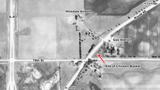
Aerial photo of Hinsdale airport in 1939. Source
Click map to enlarge
The image (click on it to enlarge it) is a 1939 aerial photo of Hinsdale Airport. The corner marked with the red arrow is vacant, it would be the site where the Chicken Basket would be located. The building close to it, is the original gas station where Kolarik began his first restaurant venture.
Historic Dell Rhea’s Chicken Basket
Listed in the National Register of Historic Places & Route 66 Hall of Fame Inductee
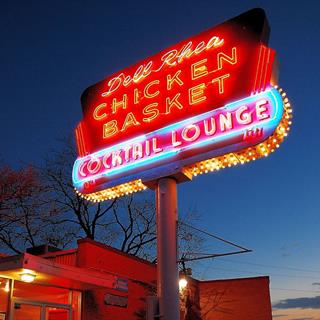
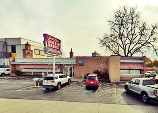
The main Route 66 attraction in Willowbrook is the Historic Dell Rhea's Chicken Basket. To your left, at 645 Joliet Rd. opposite the vanished airport.
If you are driving along I-55, use Exit 274 to reach the Chicken Basket. These are the maps with directions:
Erwin "Irv" Kolarik opened his gas station in what was then farmland south of the town of Hinsdale, in the late 1930s (you can see it in the aerial picture, further up). He not only had gas and a garage, but also a small lunch counter where he sold fried chicken using the recipe of two local farm women, who had given it to him in exchange for his promise to buy their farms' chickens.
Traffic grew and his location was excellent (Hinsdale airport was across the street) so he modified his two-door garge into a larger dining area. In the mid-1940s, he bought the plot of land next to his diner and in 1946 he built a completely new building, the current restaurant.
Designed by Eugene F. Stoyke it had a flat steel roof and large windows. It was also a stop of the Blue Bird (a regional bus service). In 1956 a lounge wing was added.
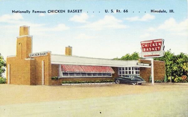
The back of the postcard above reads"Nationally Famous CHICKEN BASKET (A Delicious Surprise) - Spacious dining Room - Air Conditioned - Visit our Patio - GLASS ROOSTER COCKTAIL LOUNGE in connection. Chicken Basket - U.S. Rt. 66 - Hinsdale, Ill. Phone: Hinsdale 2769 - "Erv" Kolarik, Prop."
Kolarik sold out in 1959 when he learned about I-55 was to be built through the area. The new owners went broke as traffic stopped flowing with the freeway's completion (1962).
However, Delbert "Dell" Rhea knew it had potential, so he bought it in 1963 and kept it going as a successful business since then. It is still in the family.
Except for the fabulous 1950s cars in the following picture, not much has changed at the Chicken Basket.
Vintage photo of Dell Rhea’s Chicken Basket in Willowbrook, Illinois
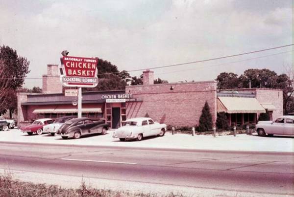
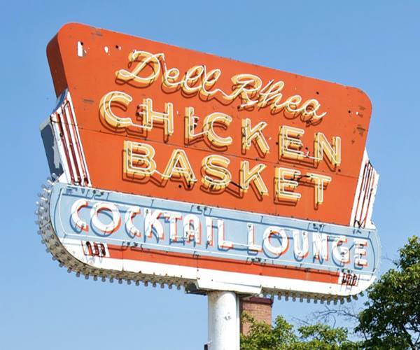
The image above shows the neon sign with the inscription "Nationally Famous Chicken Basket Cocktail Lounge." The text would be changed when Dell Rhea took over, he added his name where it said "Nationally Famous" as you can see below.
Across the street from the historic restaurant was Hinsdale Airport, diners would watch the planes taking off and landing as they ate at the Chicken Basket.
Route 66 Centennial Monument and Selfie Stop
Like in Burr Ridge, here there is another Selfie Station with a hollow Route 66 shield and a large "66" next by the neon sign. Ideal for a great photo opportunity!
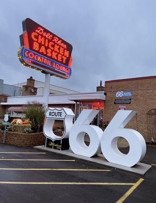
Continue your journey westwards. At the Chicken Basket, the original alignment of Route 66 is cutoff by the freeway, so you must continue along the North Frontage Rd to reach Welco Corners; it is a roundabout journey and this map with directions shows the way. The modern cloverleaf exchanges at Cass Ave and Lemont Rd. plus the exchange of I-55 with I-355 also cut the original roadway.
At IL-83 you leave Willowbrook, and enter Darien.
Darien
Elevation: 751 ft (229 m), pop: 21,584 (2022).
Cass
The original farming community here was Cass, dating back to the 1830s, on the Frink & Walker's Stage Coach Route linking Chicago with Ottawa that ran along the course that later became Route 66. It served the nearby Illinois & Michigan Canal, which opened in 1848 and there was an inn ran by Thomas Andrus in the small community.
Lace
In the 1850s, German Lutherans settled roughly one mile north of Cass, founding Lace, with its church and school.
Over the next decades Lace thrived while Cass was too close to Lemont to prosper.
After WW II, suburban growth reached the area. Lace's school was replaced by a new one in the early 1950s. The communities grew and the local homeowners voted to incorporate as a town in 1969. They named it Darien after the city of Darien in Connecticut which in turn was named so after the Spanish Panamanian province of Darien.
Castle Eden, the "White House" in Darien
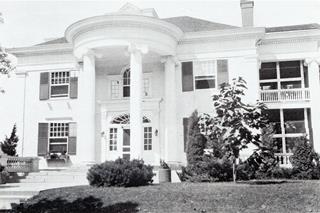
Castle Eden, 1929, a replica of the White House, Darien IL. Source
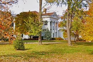
After passing the Cass Ave cloverleaf exchange, there is a large property between the Cass and Bailey Rd. north of Route 66 (8419 Bailey Road). It was originally the residence of Marting Barnaby Madden (1855-1928) and his family. Madden was born in England and migrated as a young man with his family to Lemont, Illinois where he worked on the Illinois & Michigan Canal and eventually became its president.
Madden, a Republican, served in the Chicago City Council from 1889 to 1897 and in 1904 he won a seat in the U.S. House of Representatives and served in congress until his death in 1928.
He married Josephine Smart in 1878, and in 1903 built a summer home for his family on the Smart family property here in Cass. It was his 25th wedding anniversary for his wife. The Smarts, Elisha and Eliza had been some of the first settlers in Cass.
He built a 1 ⁄ 10 scale model of the U.S. White House. He named it "Castle Eden," after one of his favorite childhood places in England, a mansion in Duhram.
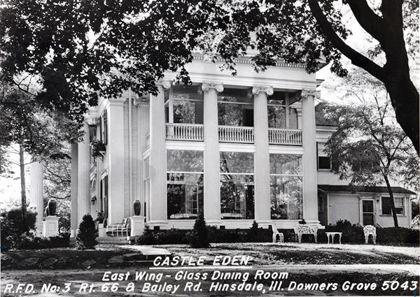
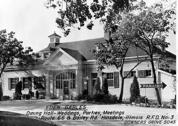
After Madden's death, the family rented it to the Thayers, who opened a restaurant and Eden Gables, for receptions and weddings. The family sold it to the Carmelite Order with ten acres of land. It became the the Aylesford Retreat Center of the Carmelite Fathers and now is the Carmelite Spiritual Center. The Carmelites now own 40 acres of land here on their Campus which inclu des not only the Carmelite Spiritual Retreat Center, but a gift shop, the National Shrine and Museum of St. Therese, and a Meditation Garden.
Continue your Road Trip
This spot marks the end of this leg of your road trip through Willowbrook. The highway continues west for 1⁄2 mile and approaches the freeway. The original alignment continued on the south side of I-55, now its S. Frontage Rd. It is cut at the cloverleaf on Lemont Rd. and by I-355's exchange, but nothing remains of any classic stops in this section. Ahead is a fork in the alignment at Welco Corners. We cite Rittenhouse's 1946 guidebook:
About 25 miles from City Hall, you will reach a fork in the road, where main US 66 goes ahead to Plainfield and alternate US 66 forks left to Joliet. Rittenhouse (1946)
He adds that you can take either course because they meet further west and that he will describes the main and not the alternate routes in his guide, so he continues to Plainfield.
The alternate alignment of Route 66 (from 1940 to 1967), was the 1928-40 Route 66 and heads west here towards Romeoville, you can take either road. Both roads meet in Braidwood.

Sponsored Content
>> Book your Hotel in Chicago

Credits
Banner image: Hackberry General Store, Hackberry, Arizona by Perla Eichenblat
Jack DeVere Rittenhouse, (1946). A Guide Book to Highway 66.


