Route 66 in Wilmington IL
Index to this page
About Wilmington IL
Information, facts and trivia
Elevation: Elevation 649 ft (198 m). Population 5,578 (2024).
Time zone: Central (CST): UTC minus 6 hours. Summer (DST) CDT (UTC-5).
Wilmington is a city located on Route 66 in Will County in NE Illinois
History of Wilmington
This region was peopled at the end of the last Ice Age some 11,000 years ago by hunter gatherer Paleoindian groups. In more recent historic times, the Potawatomi Tribe had a camp on the Kankakee River Island.
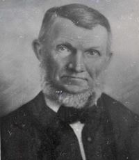
Portrait of Thomas Cox. Source
The first Europeans to explore the area were French fur trappers in the mid 1600s. The territory was incorparated into "New France" (Canada), but ceded to Britain after the Seven Year War in 1763. Soon after it became part of United States (1776) as a territory and later incorporated to the union as the state of Illinois in 1818.
Will County was established in 1836 and named for Dr. Conrad Will, a member of the first Illinois Constitutional Convention and member of the Illinois Legislature.
Thomas Cox staked a claim on the land that same year and used the strategic Kankakee river as a site for his saw mill. He platted the town and named it "Winchester", however there already was a town with that name in Illinois so he was forced to change it. Some of its first settlers, who came from Wilmington Ohio, suggested the name of their hometown, and it was approved.
The name: Wilmington
Named for Wilmington, Ohio, itself named for Wilmington, N.C. which in turn had been named after Spencer Compton Earl of Wilmington.
Compton (1673 - 1743) was a British statesman and was Prime Minister from 1742 until his death in 1743. The name Wilmington is that of a place in Kent which means "Estate associated with a man called Wighelm" (or Wynhelm, or Wilhelm).
Cox then built a grist mill and a carding mill (for wool and cotton) The railroad arrived in 1854 and a depot was built. The city was chartered in 1865.
It was a trading city and it also cashed in to the coal boom that began in the 1870s in the area.
State Higway 4 was built and paved through the city in the early 1920s and Route 66 was aligned along it in 1926. In 1940, US 66 moved furhter west and its former alignment was renamed ALT US 66.

Hotels and Motels in Wilmington
There are several hotels in Wilmington and in the neighboring towns along Route 66.
>> Book your Hotel in Wilmington
Find More Accommodation near Wilmington along Route 66
Below you will find a list of some of the towns along Route 66 east and west of this town; click on any of the links to find your accommodation in these towns (shown from east to west):
Along Route 66 in IL
- Hotels in Illinois
- Route 66 Starting point ▸ Chicago
- Lockport
- Willowbrook
- Bolingbrook
- Plainfield
- Romeoville
- Joliet
- Wilmington
- Dwight
- Pontiac
- Chenoa
- Normal
- Bloomington
- Atlanta
- Lincoln
- Springfield
- Raymond
- Litchfield
- Staunton
- Williamson
- Hamel
- Edwardsville
- Collinsville
- Troy
- Glen Carbon
- Pontoon Beach
- Granite City
- East St. Louis
West in Missouri
- Hotels in Missouri
- Florissant MO
- Bridgeton MO
- St. Louis MO
- Kirkwood MO
>> See the RV campground in Joliet and Braidwood
The Weather in Wilmington
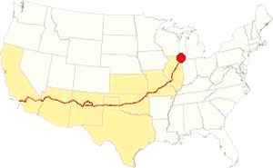
Map showing the location of Wilmington, Illinois on U.S. 66
Wilmington's climate is humid and continental; with very well defined seasons: Spring is cool and wet; summer is hot and frequently humid. Winter is cold and has on average 28 inches (71 cm) of snow, while fall is very mild.
Temperatures: Average high in Jan (winter) 31°F (-0.3°C) and the average low is 17°F (-8.6°C). Average high in Jul (summer) 84°F (29°C), with an average low of 64°F (17.7°C).
Rain averages 36.82 inch (936 mm) per year and it is highest, 3 to 4.3 inch monthly (78 and 110 mm), after April. The rest of the year has an average of 1.7 in. (28 mm) per month.
Snow: In Wilmington you can expect snow from October to April, however usually the first snow falls in Nov. and the last fall happens in April (usually one quarter inch -8 mm).
Tornado risk
The area around Wilmington gets some 4 tornado hits yearly.
Tornado Risk: read more about Tornado Risk on U.S. Hwy 66.
Map of Route 66 in Wilmington, IL
>> Our Custom map shows the alignments of U.S. 66 in Wilmington.
The map below was published in 1924, two years before Route 66 was created. It displays the "Auto Trails" or roads that were suitable for cars. The ones near Wilmington are marked with numbers: as "34" for the "Lincoln Highway" through Joliet and Plainfield, or "13" for the "Mississippi Valley Highway" from Lyons, to Joliet and west across Wilmington. The number "4" inside a white circle is State Highway 4.
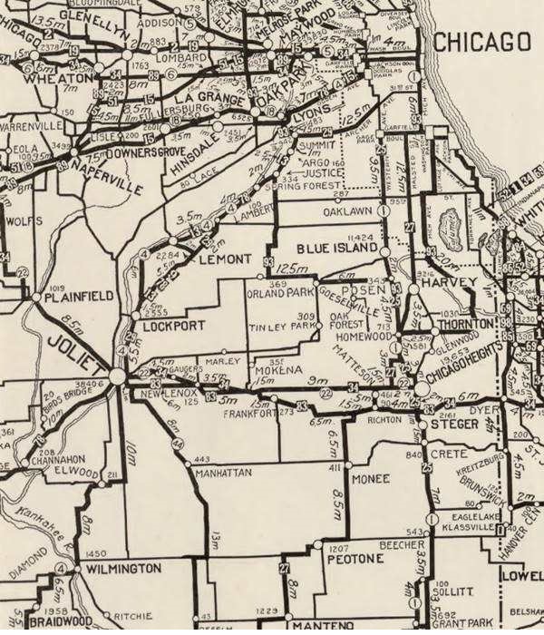

1928 Illinois State roadmap (see State Hwy 4A). Source
Click map to enlarge
To create better roads, the state of Illinois issued a bond in 1918. One of the highways built with it was known as SBI 4 (State Bond Issue #4). It linked Chicago with St. Louis and passed through Wilmington, Joliet and then northeast through Lockport and Lemont, Justice and Summit into Lyons.
It was paved completely by 1923 but in 1926 it was realigned along a new road that was built north of Joliet through Romeoville which became Route 4, (the former alignment became State Hwy. 4A).
That same year, Route 66 was created and aligned along Route 4's roadbed.
Route 66
US 66 1926 to 1939
The first alignment across Wilmington is shown with red and green lines in our custom map.
ALT US 66 1940 to 1967
As the truck traffic grew during the war the road between Wilmington and Joliet was widened to four lanes, at the same time another straighter alignment built to the west, through Plainfield and it was named US 66; see the yellow line in our custom map. The older alignment became ALT 66.
This ALT 66 alignment ran south from Romeoville through Joliet, Elwood, Wilmington, Braidwood, Godley and Braceville, meeting the Main 66 at Gardner.
ALT US 66 remained unchanged until 1967. It was eliminated in February 1967 and replaced by Illinois State Highway 53 from Welco Corners to Gardner.1
US 66 final years: 1958 - 1977
In 1958 US 66 was moved east west to a brand new freeway that now bypassed all the towns including Plainfield, Braidwood and Gardner. US 66 and I-55 shared the freeway until 1977; see the violet lines in our custom map west of the Kankakee River (near Braidwood), and east of Plainfield.
Alternate US 66
In 1959 the American Association of State Highway and Transportation Officials (AASHTO) came up with the "Alternate" designation.
It was to be used to designate a highway that branches off from the main one, passing through certain cities and then links up with the main route again.
If the Main and alternative routes followed a similar course, the better built or shorter highway would be the one marked as "Main", while the other would become the "Alternate" one.
There are only six places along Route 66 where an Alternate 66 alignment existed: From East to West they were this one close on Route 66 into Chicago, Carthage MO, the one in Joplin MO, Oklahoma City, Alt 66 in San Bernardino, California, and the one leading into Los Angeles CA.
Route 66 is a Historic highway and has also been designated as a National Scenic Byway and an All-American Road in the state of Illinois.
The Route 66 alignments near Wilmington
Description and interactive maps of US 66.
- Pontiac to Springfield (next)
- Chicago to Pontiac (Wilmington's)

Wilmington's Route 66 Landmarks and Attractions
What to see in Wilmington
US 66 in Wilmington: historic context
In 1946 Jack DeVere Rittenhouse did not mention it in his "Guide Book to Highway 66" published in 1946 because he drove along US 66 (and didn't use ALT 66). The WPA's guide to the state of Illinois published in 1939, shortly before the highway was redesignated, does mention it as part of its Route 66 tour. It pointed out that the city "manufactures roofing and serves as a shopping center for Kankakee River resorts..." and that it had an "Island Park a 35-acre wooded island in the Knakakee River is one of the popular picnicking spots... restaurants, cabins for rent..."
Your Route 66 Road Trip through Wilmington
Begin your tour driving westwards from neighboring Elwood.
Historic Alternate Route 66 Wilmington to Joliet
Listed in the National Register of Historic Places
What is now Illinois State Highway 53 between Joliet and Wilmington is the 1920s Route 66 which in 1940 became Alternate Route 66.
World War II traffic to and from the Arsenal at Elwood led to a new set of lanes be built, converting the highway into a limited access four-lane divided highway which was constructed between 1942 and 1945. Westwards from the Arsenal to Wilmington, it remained a regular 2-lane highway.
It was wide and sturdy with a 24-foot wide roadbed with 10-inch thick Portland cement slab.
Ahead, 1.7 mi. from the end of the four lane road, the highway curves to the right with a SW course on the eastern side of Wilmington and just after crossing the bridge over Forked Creek, to your left is a Classic Neon Sign.
Neon Sign at Lombardi
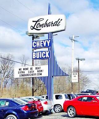
Retro Neon sign at Lombardi, Wilmington, Il. Credits. Click image for St. view
Classic neon sign
At 901 E Baltimore St. The sign is part of the former Lombardi Chevrolet and Buick Inc. The neon sign has a genuine 1950s-60s look to it; made in 1958 by Lotz Sign Company. There has been a dealership at this place since it was opened by the Butcher brothers (the same who built and ran The Mar movie theater here in Wilmington). They sold it to the Lombardi family. In 2021 it was acquired by Arnie Bauer.
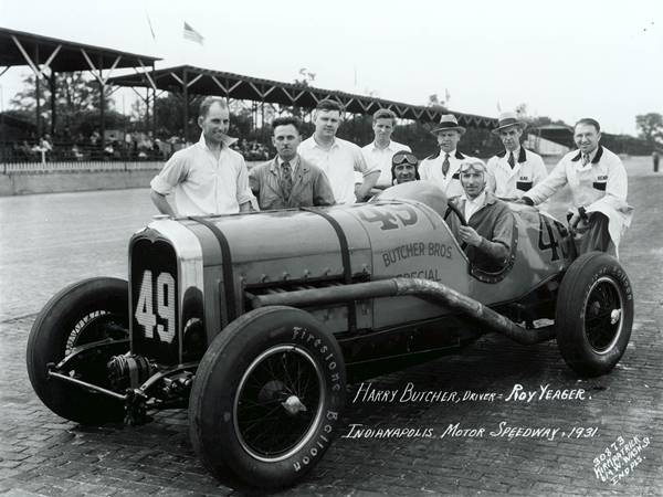
Harry "Hank" Butcher (1895-1942) was a racer, and his brother James R. Butcher was the mechanic. They fixed their own Buick, thd "Butcher Brothers Special"and raced in the 1920s and early 1930s. Harry's obituary mentions that "in 1931 [he] Won 500-Mile Auto Race at Indianapolis" but the information isn't correct they arrived 14th in 1930 and retired before finishing in 1931. Below is a picture of Hank and his car at that race.
Gemini Giant's original Site
On the next corner, at 810 E Baltimore St. (NW corner with Daniels St.) to your right was the original site of Wilmington's best known ladmark, the The Gemini Giant at the "Launching Pad" diner.
The Launchpad Diner
Illinois Route 66 Hall of Fame Inductee
The restaurant originally opened in 1956 and it was named the "Dairy Delight" (or Dari-Delite). It was owned and ran by John and Berenice Korelc. but changed its name in 1965, it adopted a "Space Age" name: The Launching Pad.
Korelc retired in 1986, and his daughter sold it in 2007 but it closed in 2010. It reopened when Tully Garrett and Holly Barker purchased it on October 17, 2017. But the covid-19 pandemic, ailing economy and competition from large chains pushed them out of business. By Dec. 2022 they announced they were closing, and the restaurant and the Gemini Man were put on sale in Nov. 2023. The restaurant is still for sale.
Gemini Man
Illinois Route 66 Hall of Fame Inductee
Considering the name of the diner, it was fitting to have a giant Muffler Man dressed up like an astronaut. Korelc bought one, and it cost $3,500 back in 1965 (about $26,000 in 2018 dollars adjusted for inflation).
Muffler Men were a popular type of roadside advertising in the 1960s. This one is a 30 foot-tall (9.2 m) fiberglass statue, one of several that are located on Route 66.
It was named by one of Wilmington's schoolchildren, Cathy Thomas who suggested the name "Gemini Giant" in a contest to name it.
Gemini Giant, viewed close up in Wilmington, Illinois at its original site
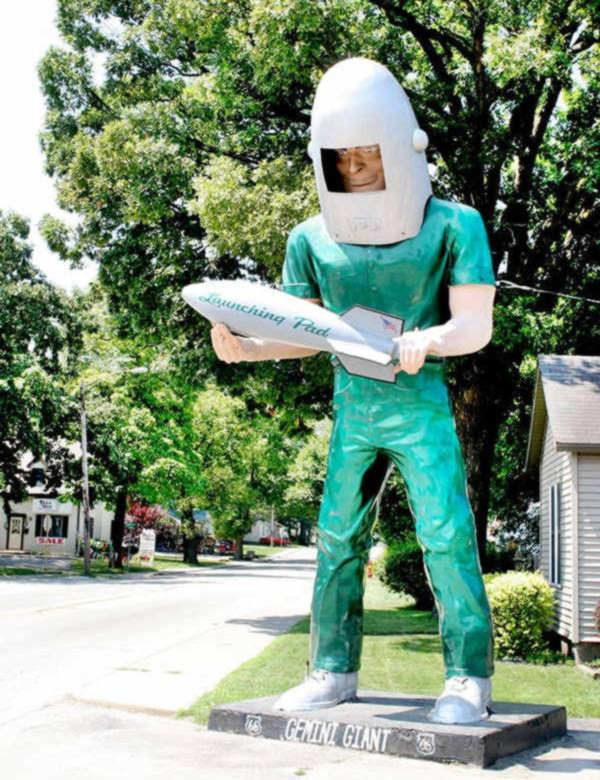
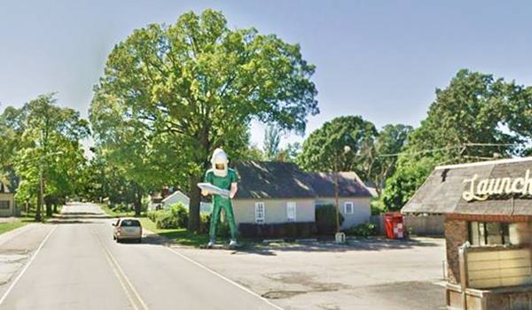
See it below and compare its size to the car driving along Route 66 at its original site (now it has been moved).
The Gemini giant from afar, compare size with trees and car!
Its name comes from the Gemini Project, a NASA space program:
Project Gemini
NASA ran this program from 1961 to 1966, employing the Gemini spacecraft that could carry two astronauts. Its predecessor, Mercury could only carry one. Apollo carried three.
The 12 missions flew in low Earth orbit trajectories and developed the techniques later used during the Apollo Moon missions such as working outside the spacecraft (extra-vehicular activity), orbital docking, and rendeazvous maneuvers. With these new techniques proven by Gemini, Apollo could pursue its prime Moon mission without testing new techniques.
Space Age on Route 66
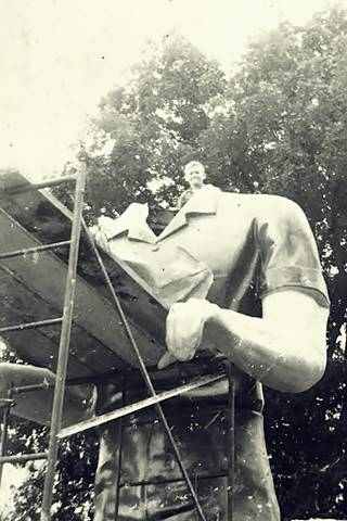
Gemini Giant being erected, Wilmington, Il. Source
The "Space Age" period was one of great excitement and novelty, technology captured everybody's minds. This "muffler man" was a modified Paul Bunyan, who switched the ovesized axe for a 9 foot long silver space capsule.
The shirt, jeans and boots were all painted green (not at all the color of the Gemini space suits - that had a metalized silver color). And the space helmet resembles a welding mask, very unlike those used by the astronauts.
There are many Space Age relics along Route 66, specially as googie-styled motels or cafes like Roy's Cafe or the Imperial Motels.
>> Learn more about the other Muffler Men on Route 66
Auctioned and Saved
The sale of the diner fell through, but the Gemini Giant was auctioned off on March 20, 2024. It was bought for $275,000 by the Joliet Area Historical Museum after a bidding war. The Museum used a state grant to fund it. They donated it to the City of Wilmington, who moved it to a safe place to restore it and repair its internal support structure prior to putting him back on display by Route 66 in a new location here in town, at the new South Island Park, where it was set up and re-dedicated in a ceremony on Nov. 30, 2024.
Sinclair Dinosaur
Kitsch and Americana
Continue your drive into town, six blocks ahead, to your right at 200 E. Baltimore Stis the other "giant" statue in Wilmington.
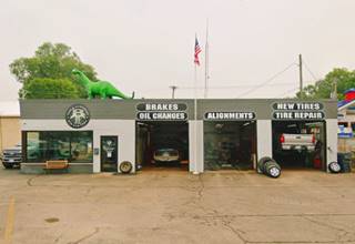
You will spot a dinosaur statue on the roof of the former Sinclair gas station, now BTI Tire and Alignment. There is a very interesting story behind it.
The first service station on the property was Elmer Francis Hulbert (1900-1973), he owned a Shell service, pictured below in a building that already appeared in the 1907 Sanborn Fire Insurance map of Wilmington. Later, in the 1950s he appears to have partnered with Crichton as their advertisement shows both as owners.
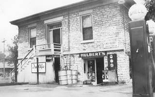
Elmer Hulbert's Shell Source. Click to enlarge
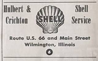
Hulbert and Crichton Shell ad. c.1950s. Source
Wilmington's Sinclair service station opened in 1963, in a new building on the property where the Shell had once stood. It was run by the Stainbrook brothers: Harold (1925-2019), after serving in the Army during WWII, he worked as an auto mechanic, and Bobby Gene (1930-2020). They owned and operated it for over 30 years.
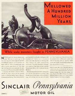
1930s Sinclair ad. Source
Sinclair Oil Corporation was founded in 1916 when Harry Sinclair merged eleven oil companies into one.
Sinclair used dinosaurs in its advertising back in 1930 as part of an campaign for their lubricants. At that time oil was believed to have been formed when dinosaurs roamed the earth (200 - 65 Million years ago).
The advertising campaign used several kinds of green dinosaurs but the one that attracted most attention was the "Brontosaurus", a gentle lumbering creature.
Nowadays the scientists have renamed the Brontosaurus as Apatosaurus, but everyone knows the Sinclair dinosaur as "Dino" (Dye-no) which was registered as a trademark in 1932.
Life sized dinosaurs promoted Sinclair at the 1933 Chicago and the 1964 New York World Fairs. The small fiberglass dinosaurs appeared in the early 1960s.
The Wilmington Dino was set up at the gas station when it opened in 1963, but vanished later. According to one online source, "this Sinclair Dinosaur statue... disappeared. Since 1975, this statue has been installed in a residential backyard in Elwood."
Sinclair dinosaur in 1963 in Wilmington, Illinois
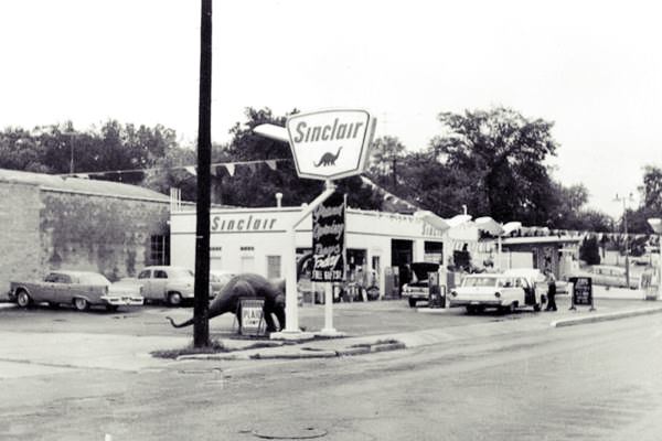
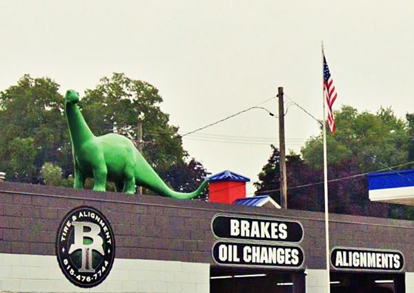
Since 2001, G&D Tire and Alignment occupies the same building of the old Sinclair station. Its owner, Gary Geiss bought a dinosaur statue in 2006 (on e-bay) bringing it from a Sinclair station located in Chattanooga, Tennesee.
The fiberglass statues were made by International Fiberglass Co., but, they stopped production in 1974 and closed two years later. The original molds no longer exist. Fortunately, Sinclair had a new one made in the 1980s based on an original dino from Colorado. The dino on the roof of the tire shop is an original one, over 45 years old.
The statues came in two sizes 12 and 8 feet long.
The shop was sold and since 2019 is BTI Tire and Alignment.
The Mar Theater
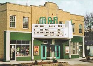
The Mar movie theater, Wilmington, Il. Source. Click for St. view
Before continuing into the Commercial District, drive one block east (to your left) along Main Street, to visit a classic 1930s movie theater.
121 S. Main St. The theater opened in 1937 and was owned by the Butcher brothers (already mentioned further up); they had it built with air conditioning and heating (at a cost of $50,000 of those days). The Mar seats 300 moviegoers. It has its original marquee, ticket booth and lobby, and is still open showing movies.
Historic Water Street Shopping District
Return to Route 66, turn left. The next street is the main downtown throughfare, Water Street with its Historic Water Street Shopping District. This crossroads had several buildings, only one remains. The following images show this spot over the years.
From the Water tower (now gone), looking towards the west (the numbers are explained in the text).
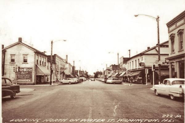
Looking north along Water St. at its intersection with Route 66 in the 1950s.

On the SE corner, to your left there is a small plaza with a mural. This was the site of the old First National Bank building that was torn down in Oct. 1995 to widen the intersection. It had housed the public library and also was the location for a scene from "Planes, Trains and Automobiles" a 1987 movie starring Steve Martin and John Candy, the Trans Missouri Bus Depot.
The building with columns on the corner can be seen in the picture further up, on the right side, by the 1955 Chevrolet (white car).
Bullock's Restaurant (gone)
Across Route 66 on the other, larger plaza on the NE corner, known as Claire's Corner Park, once stood Bullock's Restaurant, a two story gable roofed building. We marked it with a ➀ in the 1920s picture.
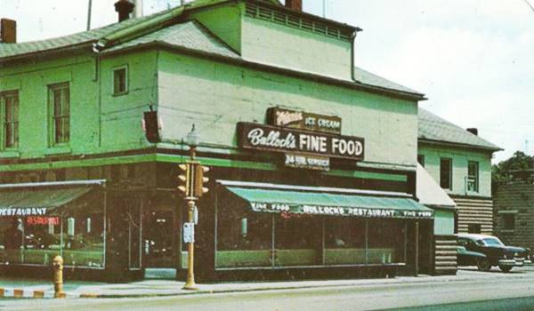
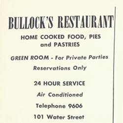
Bullock's Restaurant ad. c.1950s. Source
The restaurant was opened by Oscar and Marie Bullock in 1954 and ran it until the property was sold in 1969-70. It became a Ford Mercury dealer owned by Denny and Ruth Sartore. It can be seen on the corner on the right, beyond the bank, the word "Bullock" and "Cafe" on the corner sign are visible in the picture further up. Notice the traffic lights on the intersection. As with the bank, the city puchased it and tore it down to enlarge the intersection.
Ward's Standard Station (gone)
Out of sight, to the left (by the dark car), on the SW corner of the intersection was the gas station that James Ward owned in the 1950s and 60s. We marked it with a ➁ in the 1920s picture, in those days there was a store on the property, the gas station came much later. It was a tiny building with a small parking area. There was a garge at the back of the station where Ward and Robert Peterson, his son-in-law, repaird cars. The building was torn down in 1985 to make space for a wider intersection.
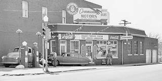
Ward's gas station c.1950s. Wilmington, Il. Source. Click image to enlarge it
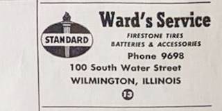
Ward's Standard ad, c.1950s. Source
Historic The Eagle Hotel
The final landmark is opposite Ward's at 100 N. Water St. on the NW corner of the intersection (with the OshKosh ad painted on its wall in the picture further up). We marked it with a ➂ in the 1920s picture.
Listed in the National Register of Historic Places
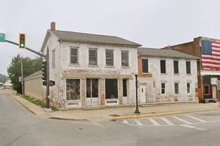
The Eagle Hotel is 90 years older than Route 66. It was built on land owned by David Lizer shortly after the town was founded, ca. 1837. It served originally as a warehouse for goods shipped out by the mills on the Mill Race that is located behind the building. It also lodged passengers of the stagecoach route that ran through the town in the 1830s.
When the Chicago & Alton railroad reached Wilmington, railway travelers stayed at the hotel. Competition appeared with the more expensive Exchange Hotel (now gone, located closer to the depot), so The Eagle focused on cheap room rental. Th 1907 Sanborn map shows it as the Schroeder's Hotel
In the 1940s it beame an apartment complex and even though a fire damaged it in 1990 it is still standing. The Wilmington Area Historical Society now owns it.
North Water Street and the Mural
This is the town's old commercial district and nowadays has many shops selling collectibles and antiques.
One block north, on the corner with Jackson St. is the Route 66 Shield mural.
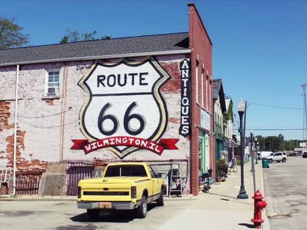
Return to the main crossroads and drive six blocks to the south along S Front Street.
The Octogon House

The Octogon House (1867), Wilmington, Il. Source. Click image for St. view
Will county Historic Landmark
From downtown Wilmington on the North side of the millrace, you can take a short detour eastwards along Water Street to visit a very oddly shaped house.
600 S. Water St.
The house was built in 1867 with an octogonal shape (eight sides to it), it is a rare type of building -only 36 have survived in Illinois. It was built by David Aldrich. After 1900 it was owned by the Monteith and then by the Schutten family.
Retrace your steps to Route 66 and Water St. to continue your journey.
South Island
Dam, Island and Mill Race
Continue westwards along Route 66, parallel to Water Street (and giving it its name) is a narrow branch of the Kankakee River known as the millrace. Cox built a dam on its northern tip to allow the water into it from the main river and used this current of water to turn the water wheel at his mill. Water powered grist mills, flour mills or sawmills to produce meal, flour and cut timber. Alden's Island or South Island is located west of the millrun. The old dam was damaged by floods in the 1990s.
The Wilmington Electric Light and Power Co. had a hydroelectric plant here on the island, you can see it in the 1920s photograph, to the right of the bridge ➃. Now there is a parking lot here.
The first bridge here, 40 feet wide, was proposed in 1871, to carry the highway across the millrace into South Island. It later carried IL-4 and Route 66. The current one was built in 1998 replacing a previous one built in 1944.
Kankakee River
The Kankakee River meets the Des Plaines river downstream (north) from Wilmington to form the Illinois River. It is 133 miles (214 km) long and it drained (a now shrinking wetland which was one of the largest in North America). it was known as "Teatiki" by the local Miami natives which meant "it is open or exposed country", name that deformed into "Kankakee".
South Island Park
Beyond the Mill Race channel of the river is the island which Route 66 crosses and most of which is a city park. We marked it with a ➄ in the 1920s picture. Here, on the western side of the Mill Race are more attractions:
Murphy's Motel
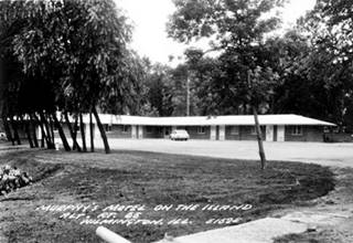
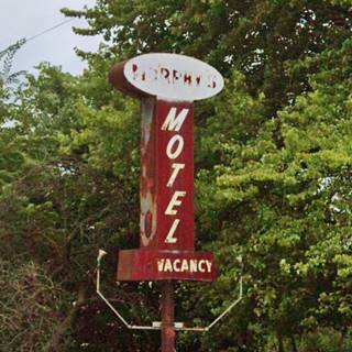
To your left, by the bridge, at 107 Bridge St. This motel has an interesting neon sign, once topped by a gigantic catfish. It's self proclaimed claim to fame is on a billboard: "the best motel by a dam site", a reference to the Kankakee dam. It originally had one story and 16 rooms in the 1950s to 80s when it was Murphy's motel; but by 1996 had grown to 22 rooms and 2 floors. The rusting neon sign still reads "MURPHY'S MOTEL." Now it is the Super Shie motel.
Nelly’s Restaurant
Across the street by the north side of the bridge end, is Nelly's and the Wayside Exhibit (in the parking lot) at 140 Bridge Street
Nelly's is a well known burger and hot dog restaurant that openeed in 2010, its patrons can write on marker boards or sign the ceiling, flags hanging from the beams come from the visitor's countries.
The exhibit lists the Route 66 Attractions in the Wilmington Region, which we have mentioned here and in our pages on Elwood, Braidwood, Godley, Braceville, and Gardner.
Park Drive Cafe (gone)
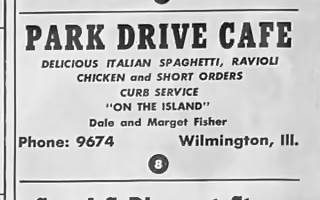
Park Drive Cafe ad. c.1950s. Source
The Park Drive Cafe ran by Dale and Margaret Fisher offered "Delicious Italian Spaghetti, Ravioli, Chicken and Short Orders. Curb Service. "On the Island"." The map by the ad and aerial photos show it on the north side of the highway, probably where the Wilmington House Family restaurant is located.
New Park and Route 66
The city has approved park plans, relocating S Park St. further east (along the western side of the motel), and creating a parking space a new sign for the City with Route 66 centennial connotations, and of course a new display point for the Gemini Giant. This will be completed by summer 2025 but the city council has implemented a plan to built the new monument foundation for the Gemini Giant sooner, placing the Gemini Giant here on Nov. 30, 2024.
Continue west across the island, and on its western side is the main arm of the Kankakee River. Here, just upstream is the Dam:
Kankakee River Dam
The dam was built in 1904 It is a low-head dam, because the water can flow over it. It is only 11 ft. (3.4 m) high. This type of dam is very dangerous: invisible for those coming downstream it seems safe to cross, but it has killed at least 20 people since 1984 and another 25 have been rescued alive.
The current drags the unaware swimmer down at the base of the dam so to survive the person must drop to the river bed and drag him or herself along it to escape the churning waters, and only then resurface.
On the western side of the island, the Kankakee River had several bridges, one in 1913 , another in the 1930s which had seven concrete arches. These ran with a straight course across the river. The current bridge was built in 1897 and has curved alignment.
Ahead on the curve that heads south towards Braidwood, was Jack's Service Station ran by Joe and Marie Nowman, a Phillips 66 on the SEc corner of the curve where the Circle-K and Burger King now stand.
Continue your Road Trip
Your Route 66 Road Trip across Wilmington ends here, now head west to visit the next town, neighboring Braidwood use ALT 66 to reach it.

Sponsored Content
>> Book your Hotel in Chicago

Credits
Banner image: Hackberry General Store, Hackberry, Arizona by Perla Eichenblat
Jack DeVere Rittenhouse, (1946). A Guide Book to Highway 66.


