Route 66 in Countryside IL
Index to this page
About Countryside IL
Facts, Information and trivia
Elevation: Elevation 699 feet (213 m). Population 6,205 (2022).
Time zone: Central (CST): UTC minus 6 hours. Summer (DST) CDT (UTC-5).
Countryside is a city located in Cook County, Illinois, and is a suburb in the Metropolitan Area of Chicago.
History of Countryside
This region was first inhabited by Paleo Indians some 11,000 years ago when the ice sheets receded and melted at the end of the last Ice Age. Their descendants, the
Potawatomi people lived here at the time of the arrival of the first Europeans in the 1600s.
The French explored the area and incorporated it into their province of New France (Canada). The British took control of it in 1756 after winning it in the Seven Year War. The U.S. acquired the territory with its independence from England and in 1803 established Fort Dearborn where Chicago is now located. The territory incorporated to the American Union in 1818 as the state of Illinois.
Joseph Vial settled with is family in what was then known as Flag Creek in 1833, just two years after Cook County was created.
Cook County was named after Daniel Pope Cook (1794 - 1827) a politician, lawyer and newspaper publisher. The state's first Attorney General. Congressman and anti-slave advocate.
Trivia
Cook County is after Los Angeles County, the second-most populous county in the US, and Chicago is the county seat.
The area was a farming community when the Congregational Church of Flagg Creek was organized in 1843. The cemetery, beside to the church was established in 1848 and the post office of the community changed its name from Flag Creek to Lyonsville in 1850.
Lyonsville's Congregational Church's building, or sanctuary, was erected in 1858 and stood until a new one replaced in in 1960.
LaGrange
Two miles north of what is now Countryside, in 1870 Franklin Cossitt purchased farmland on the "Old Plank Road" or Chicago-Dixon Road, built along a Native American trail and built a modern suburb for Chicago. The Great Chicago Fire of 1871 helped promote its growth as many of its homeless citizens moved there. The railway alowed for an easy commute. The city incorporated in 1879, named for Cossitt's hometown in Tennessee.
Hodgkins
One mile and a half to the southeast is the village of Hodgkins, first settled during the consturction of the Illinois & Michigan Canal built between 1836 and 1848 to link the Great Lakes with the Mississippi River to move produce and trade to and from the eastern states. The canal linked the Chicago River across the Chicago Portage, with the Des Plaines River. Canal workers settled here and worked in the quarries; the village incorporated in 1896 named for Jefferson Hodgkins, the president of the Kimball and Cobb Stone company.
Farms and open countryside
But what is now Countryside remained as farmland, and even the famous comedians, the Marx Brothers had a chicken farm in the area in 1917, to avoid being drafted during World War I.
When Route 66 was aligned through here along a newly paved roadway in 1928 it was still an open countryside with fields. In 1939 the WPA described it as follows: "Lyonsville marks the eastern limit of the flat lake plain of ancient Lake Chicago, the forerunner of Lake Michigan. Westward lies the faintly rolling, wooded Valparaiso Moraine, one of the long crescent ridges of debris left by the glaciers."
The suburban sprawl that followed the post World War II period began expanding west, and the area was developed during the housing boom of that period (1947 and 1950s). Indian Head Park to the west underwent a similar process birth and of growth during that period. The whole area became a bedroom community for neighboring Chicago, these tonws incorported shortly after, Indian Head Park in 1959, the City of Countryside in 1960. Shortly after, the I-55 Freeway was completed.
The name: Countryside
Named for the countryside with farms, fields and forests, previously Lyonsville after the county township created in 1850: "Lyons Township".

Accommodation in Countryside
> > Book your hotel in Chicago
Find More Accommodation near Countryside along Route 66
Below you will find a list of some of the towns along Route 66 east and west of this town; click on any of the links to find your accommodation in these towns (shown from east to west):
Along Route 66 in IL
- Hotels in Illinois
- Route 66 Starting point ▸ Chicago
- Lockport
- Willowbrook
- Bolingbrook
- Plainfield
- Romeoville
- Joliet
- Wilmington
- Dwight
- Pontiac
- Chenoa
- Normal
- Bloomington
- Atlanta
- Lincoln
- Springfield
- Raymond
- Litchfield
- Staunton
- Williamson
- Hamel
- Edwardsville
- Collinsville
- Troy
- Glen Carbon
- Pontoon Beach
- Granite City
- East St. Louis
West in Missouri
- Hotels in Missouri
- Florissant MO
- Bridgeton MO
- St. Louis MO
- Kirkwood MO
>> See the RV campgrounds in Chicago or in Joliet and Braidwood
The Weather in Countryside
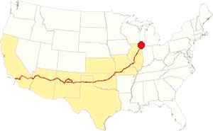
Map showing the location of Countryside, Illinois on U.S. 66
The climate of Countryside is a humid continental one with all four seasons distinctly represented; summers are hot and humid, spring is wet and cool, fall is mild and pleasant while winters are quite cold.
Temperatures: The average winter (January) high is 31°F (-0.3°C); and the average low is 17°F (-8.6°C). The summer average high (July) is 84°F (29°C) and the average low is 64°F (17.7°C).
Rainfall ranges from 3 to 4.3 (78 and 110 mm) inch monthly from April to November, and falls to a drier 1.7 in. (28 mm) the rest of the year. On average, Countryside receives 36.82 inches of rain each year (936 mm).
Snowfall: on average, 28 inches (71 cm) of snow falls each year. The first snow falls in Nov. and the last (less than 1⁄4 inch or 8 mm) falls in April. There is usually no snow between May and September.
Tornado Risk
The region around Countryside experiences about 4 tornados per year.
Tornado Risk: read more about Tornado Risk on US 66.
The Maps of Route 66 in Countryside
>> Our Custom map shows the different US 66 alignments in Countryside.
The map below was published in 1924, two years before Route 66 was created, it shows the different Auto Trails in the area around Chicago. These trails were roads that were fit to be driven by cars (not necessarily paved, but with a good hard surface). Those marked with numbers in black boxes are named trails, for instance "34" was the "Lincoln Highway" and you can see it running into Joliet and through Plainfield. The numbers inside white circles were the state highways: the "4" inside a white circle is State Highway 4. It runs through Lemont and Lockport to Joliet to the south and east of the Des Plaines River, it would be the first alignment of Route 66 in 1926. And we marked it with a bordeaux line in our custom map
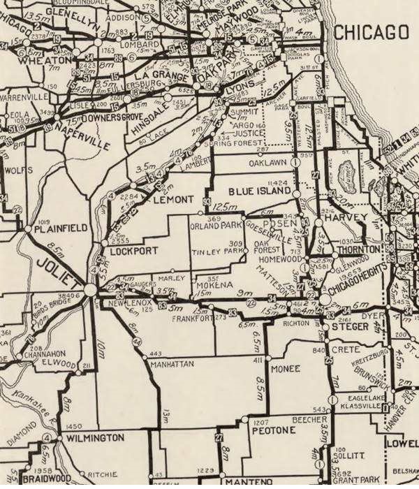
The map shows LaGrange and Lyons, Countryside does not appear in the map.
Route 66 and Countryside
When Route 66 was created in 1926 it ran further south from 1926 to 1928 from Lyons to Joliet through Lemont and Lockport, along the southern and eastern side of the Des Plaines River and the Illinois & Michigan Canal.

1927 Chicagoland map. Source

1928 Illinois State roadmap (see State Hwy 4A). Source
The 1927 and 1928 maps above don't show any towns west of Lyons on the future alignment of Route 66. The highway was realigned in 1928 along the western side of both waterways, through Romeoville (violet and pale blue lines in our custom map).
US 66 from 1956 to 1977

1969 Illinois State Roadmap. Source
Click map to enlarge
The state highway map of 1959 shows changes: US 66 south of its fork with ALT 66 is an "Expressway" with "highway separation" (overpasses and limited access). It has also bypassed Plainfield, leaving the old 1940-58 US 66 aligmnent to become IL-126 and IL-59.
During the 60's, the urban sprawl expanded. The 1969 state highway map (pictured) has I-55 and US-66 running together until the exchange with I-294, where they split, I-55 running further south and US-66 north. However it does not show Countryside.
Route 66 is a Historic highway and has also been designated as a National Scenic Byway and an All-American Road in the state of Illinois.
The old Route 66 is a Historic highway and has also been designated as a National Scenic Byway and an All-American Road in the state of Illinois.
The Route 66 alignments near Countryside
Description and interactive maps of US 66.
- Pontiac to Springfield (next)
- Chicago to Pontiac (Countryside's)

Countryside's Route 66 Landmarks and Attractions
What to see and do during your Road Trip through Countryside
US 66 in Countryside: historic context
As its name implies, this was an area of open fields and, during the "classic" days of Route 66 from 1926 to the early 1960s, this was open farmland. Jack Rittenhouse does not mention it in his iconic "Guide Book to Highway 66" published in 1946 because he started his detailed description west of this area, in Plainfield.
The WPA guide to the state of Illinois published in 1939, describes the towns along Route 66 east of Chicago up to Lyons. West of Lyons, the WPA mentions the quarry (in modern McCook): "Bordering the highway... is a tremendous limestone quarry. From a distance the narrow-gauge trains seem like children's toys scooting about the quarry floor...", in what is now Countryside it mentions the junction with US 45 and US 66 and the Lyonsville Church at the intersecton of US 66 and Wolf Rd.: "is reputedly one of the oldest Congregational Churches in northern Illinois. It served as a recruiting station during the Civil War..."
Route 66 Road Trip Leg in Countryside
Drive along Historic Route 66 from McCook westwards towards Countryside, there is a one-mile section of Joliet Road (Route 66) was closed about 2001 by the Illinois D.O.T. when the road buckled and split, hindering the safety of those driving along it. We marked the gap with a green line in our custom map.
The road closure was caused by the digging in the quarry mentioned by the WPA (operated by Vulcan Materials Company, the second largest mining company and producer of aggregate in the world), which dug so deep on both sides of the highway, that they undermined its rock foundations. Learn more about this Closed road section in McCook.
For this reason you will drive west out of McCook along 55th street into Countryside and take a sharp 90° turn south along East Ave, to return to Historic Route 66 four blocks further south. The Mother Road has a NE-SW course and has no classic sights in this stretch. Ahead it intersects U.S. 45 that has a north to south alignment, leading to LaGrange 3 mi to the north.
Orchard Rest Cabins (gone)

The 1930s postcard above tells us that Orchard Rest was located at the junction of US 66 and 45. It survived at least until 1952 because the ad tells us that Logan's Orchard Rest was located on the same spot and offered "Good Food - Modern Cabins - Open Daily, 4:00 PM." The aerial photo taken in 1938 of the crossroads shows two built-up sites and the one on the SW side seems to be the one with the cabins. The 1 on the NE side and the other on the SW side of the intersection.
Parks and Forest Preserve
South of the crossroads are two natural areas, the Theodore Stone Park and the Arie Crown Forest Preserve. The Theodore Stone Forest Preserve is a 142-acre forest preserve, with its unique dolomite prairie, oak savanna and woodland. Next to it, on the western side of US 45 is the the heavily wooded 250-acre Arie Crown Forest Preserve.
1950s motels and Drive-In Theater (gone)

1961 aerial photo of Countryside, US 66 & US 45. Source
Click on image to enlarge
There were several motels lining U.S. 45 here, serving those driving both Route 66 and highway 45. They have all been torn down, the drive-in theater suffered the same fate. The aerial view from 1961 shows each of them (click on the image to enlarge it). You can compare this view with a previous one, an aerial photo taken in 1938, that shows open fields lining both highways.
66 Drive-In
Northwards along LaGrange Rd (US 45) to your left, at 61st St. (800 ft from Route 66) was the 66 Drive-In. It opened in 1948 and closed in 1976. It could accommodate 900 cars. Now a Home Depot and a Shopping Center stand on the property.
La Grange Motor Hotel
Passing the Drive-In, to your left, at 5846 S. La Grange Rd. was another motel, its postcard below, from 1952 states: "Illinois' Newest and Finest Highway Hotel... Tile Bath and Shower, Telephone in Every Room... Julius J. Koos, Manager." Later it was renamed La Grange Motel. Now it is a parking lot next to a Cafe.

Southwind Motel
Ahead, on the eastern side of the highway (right) on the SE corner of W 57th St. where the McDonalds is now located. Its 1958 postcard below says "ULTRA MODERN SOUTHWIND MOTEL... Zoned Control... Wall-to-Wall Carpets... Glass Shower Doors Beauty Rest Mattresses."

Colonial Motel
Across the street, on the NE corner with W 57th St., at 5631 S LaGrange Rd. was a motel described in the 1961 Duncan Hines guide as follows: "La Grange... Motel: Colonial. 1 mi. S. of center. 44 rms, Ph., TV, A.C. Baby cribs, baby sitters. Free ice and newspaper. Game room with ping-pong and a pool table." Now it is a Hyundai Dealership. Pictured below.

Turn around and return to Route 66, head west along it. Ahead is the site of another razed motel.
Sunnyside Motel
It was located 300 yards west of the US66 - US 45 intersection, to your right, between the modern Holiday Inn and the Subaru dealership. However, its postcard mentions it was located on "U.S. Routes 66 and 12, 20, 45, La Grange Illinois, a short drive from Chicago's heart... has coffee shop." It was a "Member of the Congress of Motor Hotels - Diner's Club." It had a long L-shaped layout perpendicular to the highway. It was torn down in the mid 1980s.

Route 66 Wayside Exhibit
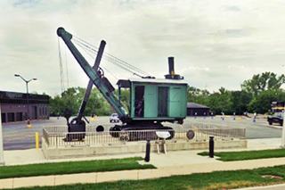
On the south side of the highway opposite the Holiday Inn, at 6202 Joliet Rd is a marker beside a steam-powered bucket shovel from the quarries of this area and a Route 66 Wayside exhibit with a panel that tells aobut the history of the area and the limestone quarries that provided the crushed limestone used in Route 66's roadbed from Chicago to Joliet.
Redwood Lodge Motor Court
Ahead was the Redwood Lodge, on the north side of the highway in the parking lot west of the Holiday Inn, its postcard described it as follows: "one block west of U.S. 45-12-20... all tile baths, tub and shower." It had tiled hip roofs over the complex. All that remains of it is the grassy entrance island -on the right side of the picture below, and shown in this St view.

Wishing Well Motel Site (gone)

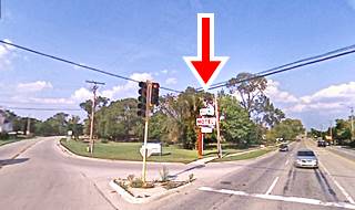
Original Wishing Well motel neon sign, Pontiac, Il (and original location -inset). Click for St. view
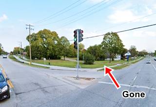
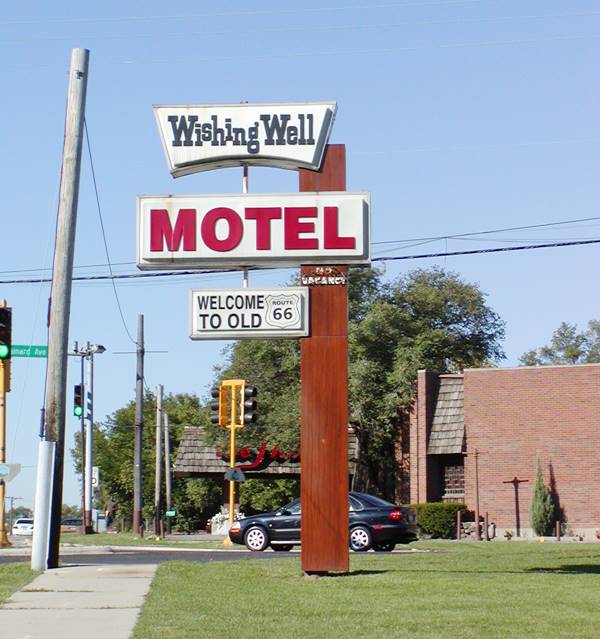
One-quarter mile west, to your right is the site of the former Wishing Well Motel at 6305 S Brainard Ave.
It was located on the northeastern corner of Joliet Road at Brainard Ave. It was built in 1941 and was run by Zora Vidas and her husband until it closed in 2006.
It was knocked down in 2009 as it became a fire risk and many vagrants lived in the vacant building.
It had 10 cabins which later became one unified structure with 19 units. There was a stone well here in the hotel's front yard.
The old neon sign and the stone well were saved from the demolition and have been placed in the Route 66 Hall of Fame Museum in Pontiac Illinois where they are on exhibition.
Below is a "Then and Now" sequence of the Wishing Well's neon sign site.
Below is another view of the magnificent Neon Sign at its original location.
Neon sign, Wishing Well motel in Countryside, Illinois
The Flame (gone)
This restaurant stood at 803 Joliet Rd. On the NW corner with S Brainard Ave. You can see it in the picture above, behind the sign, a red brick building with a wood shingle roof and a red sign on the entrance porch.
Peter Makris opened it in 1958 and was torn down in 2017. Makris expanded his chain with locations in Chicago and in Florida as well as their Lord Chumley's Pub. It specialized in charcoal broiled prime steaks.
After the death in 2012 of Peter's daughter, Nanci Makris, her family decided to close the restaurants. It was remodelled and became the "Outriggers Flame", but they also closed, the building was torn down and a local municipal building stands on the property. See this 2017 street view before it was torn down.

Contryside Route 66 Centennial Monument and Selfie Stop

Route 66 Centennial Marker in Countryside. Source
At 6402 Joliet Rd., to your left is a modern Route 66 attraction and it is a great spot for a Route 66 selfie.
It is one of many along the Mother Road sponsored by the Heritage Corridor Bueau using a $1.5 million grant from IL DCEO designed to enhance sites along Route 66 ahead of the Route 66 Centennial (1926-2026). You can find them in Joliet, Burr Ridge, Willowbrook, Romeoville, Gardner, Dwight, Pontiac, Bolingbrook, Lockport, and Plainfield.
The highway now leaves Countryside and enters the village of Indian Head Park.
Indian Head Park
Elevation: Elevation 696 feet (212 m). Population 3,935 (2022).
At Willow Spring Rd., the highway enters the village of Indian Head Park set between Countryside and Burr Ridge.
There was a log "hotel" on Wolf Road in 1834 about one mile north of Route 66 on the old Indian Trail that nowadays is Plainfield Road. Later a stage coach route ran along it. The area was a part of Cook County's Lyon Township.
In 1843 the Lyonsville Congregational Church was established here.
After WWII, suburban growth began, the Indian Head Golf Course opened and The Village of Indian Head Park incorporated in 1959.
Route 66 sights
Wolf Road Tourist Camp (gone)
The Wolf Road Tourist Camp and Trailer park can be seen in the postcard below. The aerial photos of the area show it was located on the south side of the highway where the Countryside Bank is now located at 6734 Joliet Rd. (map). It had cabins and an area for camping. As Indian Head didn't exist in those days, the postcard places it in LaGrange. Another postcard states "Shade - Quiet - Golfing," referring to the Flagg Creek golf course beside it, and the Acacia Park course (now gone) across the highway from it. It had 15 cabins.

Former Lyonsville Congregational United Church of Christ
Dates back to 1843
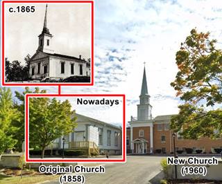
On the Southeast corner with Wolf Rd, at 6871 Joliet Road, the local congregation was established here in 1843 and used a log schoolhouse for worship. A cemetery was organized next to it in 1848 and the first sanctuary was erected in 1858 (still there!). It served as as part of the network that helped slaves escape north (the "underground railroad") during the mid 1800s and Civil War period. A new sanctuary was built in 1960 beside the original one that is still standing on the eastern side of the complex as you can see in the image. The Lyonsville Congregational United Church of Christ dissolved as a congregation in May of 2023, and the building was sold to Ebenezer Pentecostal. The Lyonsville Cemetery, was not owned by the church.
Close by was one of the last camps of the Potawatomi Indians in Illinois before their forced removal by the U.S. government west of the Mississippi River. The LaGrange Illinois Chapter Daughters of the American Revolution erected a stone monument with a bronze plaque on it in 1930 to commemorate this last campsite, and set it by Route 66 on the corner of Wolf Rd. and Joliet Rd.
Blackhawk motel (gone)

Blackhawk motel, 1956 ad. source
On the SW corner of Wolf Rd. and Route 66, opposite the cemetery was Frank A. Lassa's Motel, his advert 1956 in the image announced that it had "Reasonable Rates - Private Showers - Hot Water Heat" notice that as Indian Head didn't exist at that time, he placed it in "Western Springs." The motel appears in this 1951 aerial picture as a long narrow building. By 1973 it was gone. The Indian Head Plaza now stands on the property.
Continue your Road Trip
This spot marks the end of this leg of your road trip through Countryside. The highway continues west and merges into the freeway. Heads west along it to visit neighboring Willowbrook to continue your journey.
Sponsored Content
>> Book your Hotel in Chicago

Credits
Banner image: Hackberry General Store, Hackberry, Arizona by Perla Eichenblat
Jack DeVere Rittenhouse, (1946). A Guide Book to Highway 66.


