Route 66 in McCook IL
Index to this page
About McCook IL
Facts, Information and trivia
Elevation: Elevation 700 feet (214 m). Population 240 (2022).
Time zone: Central (CST): UTC minus 6 hours. Summer (DST) CDT (UTC-5).
The village of McCook is an industrial Chicago suburb located on Route 66's 1928-77 alignment in Cook County, Illinois. It has the lowest population of all the municipalities in Cook County. Cook County is after Los Angeles County, the second-most populous county in America.
History of McCook
This region was populated by Paleo-Indians around 11,000 years ago when the ice sheets meleted and retreated forming the Great Lakes. More recently, in the 1600s, their descendants, the Potawatomi people lived here and were encountred by the French explorers coming from Canada. Who incorporated it as part of their New France colony.
France was forced to hand it over to Britain by a peace treaty following the Seven Years Wars in 1756. After the American Independence what is now Illinois became part of the U.S. who in 1803 established Fort Dearborn on the Chicago River, where Chicago is now located. In 1818 this territory became the state of Illinois.
Cook County was established in 1835 and named after Daniel Pope Cook (1794 - 1827) who was a newspaper editor and publisher as well as an attorney. He became Illinois' first Attorney General, and opposed to slavery in Congress.
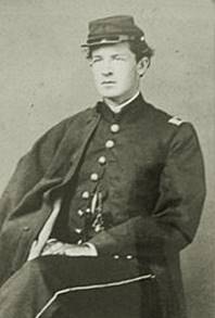
Portrait of John McCook c.1865
This area was a farming district, on the road to Joliet. On its southern side along the Des Plaines river, it was wooded and marshy. In the 1880s quarries opened here and limetone was extracted and shipped out along the Illinois & Michigan Canal and by rail.
Des Plaines River
The river runs just south of the village. It is 133 miles (214 km) long and eventually reaches the Mississippi River via the Illinois River.
It was a native route. The French explorers called it the "River of the Plane Trees" as the trees along it resembled the French plane tree.
Illinois & Michigan Canal
A group of businessmen organized to build a canal to link the Great Lakes with the Mississippi River to move their farm's produce and trade with the eastern states, and also allow goods to move west, linking the Great Lakes with the Gulf of Mexico via the Illinois and Mississippi rivers.
In 1825 the State Legislature incorporated the Illinois and Michigan Canal association, but the construction of the canal was delayed many years. Work started in 1836 and concluded in 1848. It closed for good in 1935 after being replaced by the railroad and by the Chicago Drainage Canal that was dug in the 1890s, parallel to the old I&M canal, to be used not only for navigation but also to send the raw sewage of Chicago westwards so that it didn't taint its drinking water supply (Lake Michigan) and help eliminate the constant cholera outbreaks.
The name "McCook"
Named for John J. McCook (1845 - 1911), Captain during the Civil War, he later became a director of the Santa Fe Railroad. Close friend of Teddy Roosevelt.
The surname is the Anglicized form of Gaelic Mac Cúg "son of Húg (Hugo)."
The village incorporated in 1926, the same year U.S. Highway 66 was created; Route 66 was aligned through the village in 1928 towards Romeoville, bypassing its first alignment along the south side of the Des Plaines River through Lemont and Lockport.
Despite the Great Depression, industry established plants here, like the Electro-Motive Company a subsidiary of the General Motors Corporation that produced large-sized diesel engines. Other industries also opened plants in McCook and many stores, bars and taverns opened along Route 66 to cater to the blue collar workers and also seedy joints like bars and strip clubs during the 1930s.
In 1939 the WPA described its airfield north of the highway and its quarry on the south side of Route 66. This vast McCook-Hodgkins quarry covers more than 600 acres and has an output of 7 Million tons of crushed stone yearly.
Route 66 remained aligned through McCook until its decertification in 1977. In 2001 a short stretch of road was closed to traffic because its foundations being undermined by the quarrying activity next to it.

Accommodation in McCook
> > Book your hotel in Chicago
Find More Accommodation near McCook along Route 66
Below you will find a list of some of the towns along Route 66 east and west of this town; click on any of the links to find your accommodation in these towns (shown from east to west):
Along Route 66 in IL
- Hotels in Illinois
- Route 66 Starting point ▸ Chicago
- Lockport
- Willowbrook
- Bolingbrook
- Plainfield
- Romeoville
- Joliet
- Wilmington
- Dwight
- Pontiac
- Chenoa
- Normal
- Bloomington
- Atlanta
- Lincoln
- Springfield
- Raymond
- Litchfield
- Staunton
- Williamson
- Hamel
- Edwardsville
- Collinsville
- Troy
- Glen Carbon
- Pontoon Beach
- Granite City
- East St. Louis
West in Missouri
- Hotels in Missouri
- Florissant MO
- Bridgeton MO
- St. Louis MO
- Kirkwood MO
>> See the RV campgrounds in Chicago or in Joliet.
The Weather in McCook
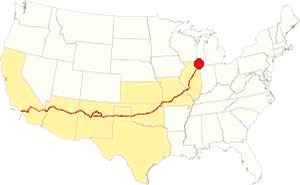
Map showing the location of McCook, Illinois on U.S. 66
The climate of McCook is classified as humid continental and has clearly marked seasons with hot and often humid summers, cool and wet springs, mild falls and cold winters.
Temperatures: Average high in Jan (winter) 31°F (-0.3°C) and the average low is 17°F (-8.6°C). Average high in Jul (summer) 84°F (29°C), with an average low of 64°F (17.7°C).
Precipitation: Rainfall is between 3 and 4.3 (78 and 110 mm) inch per month between April and November, falling to around 1.7 in. monthly (28 mm) during winter. Average rainfall is 36.82 inch (936 mm).
Snow: The city gets 28 inches of snow per year (71 cm), with the first snowfall usually taking place in November and the last one happening in April (with less than a quarter inch -8 mm). You shouldn't see snow from May to September.
Tornado Risk
The region around McCook experiences about 4 tornados per year. An EF1 force tornado hit the town in July 2023.
Tornado Risk: read more about Tornado Risk on US 66.
The Maps of Route 66 in McCook
>> Our Custom map shows the different US 66 alignments in McCook.
The map below was published in 1924, two years before the creation of U.S. Highway 66. The map displays the Auto Trails in NE Illinois around Chicago.
Auto Trails were highways that were in good conditions and could be used by motor vehicles. Some are marked with numbers inside black boxes; they are the "named trails." Like "34" that was the "Lincoln Highway" which can be seen running into Joliet and across Plainfield. Illinois State highways are marked with numbers inside white circles. For instance Route 66's predecesor State Highway 4 is marked with a "4" inside a white circle. It can be seen running from Chicago to Lyons, and then south through Lemont and Lockport to Joliet along the south side of the Des Plaines River. Route 66 was aligned along it from 1926 to 1928. We marked it with an orange line in Lyons, and a bordeaux line through Lemont to Joliet in our custom map
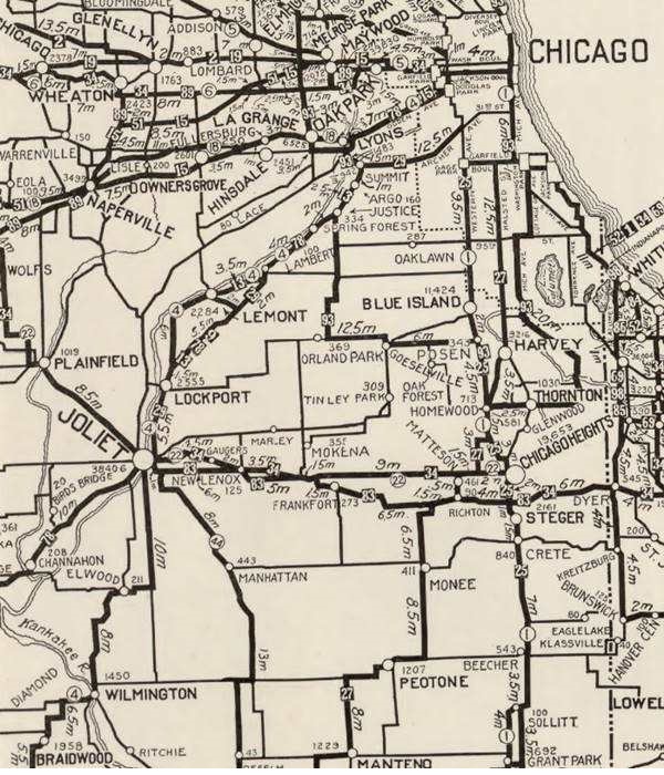
The map shows LaGrange and Lyons, McCook does not appear in the map, it is beside Lyons.
Route 66 and McCook

1927 Chicagoland map. Source

1928 Illinois State roadmap (see State Hwys 4 and 4A). Source
The 1927 and 1928 maps above don't show McCook, but it is located to the SE of Lyons. Route 66 was realigned in 1928 along the western side of both waterways, McCook, and south of LaGrange through Romeoville marked with the violet and pale blue lines in our custom map.
US 66 from 1956 to 1977

1969 Illinois State Roadmap. Source
Click map to enlarge
The state highway map of 1959 shows changes: US 66 south of its fork with ALT 66 is an "Expressway" with "highway separation" (overpasses and limited access). It has also bypassed Plainfield, leaving the old 1940-58 US 66 aligmnent to become IL-126 and IL-59.
During the 60's, the urban sprawl expanded. The 1969 state highway map (pictured) has I-55 and US-66 running together until the exchange with I-294, where they split, I-55 running further south and US-66 north. However it does not show McCook.
The Closed Section of Route 66 caused by the quarry that undermined its foundations, is shown with a green line in our custom map.
Route 66 is a Historic highway and has also been designated as a National Scenic Byway and an All-American Road in the state of Illinois.
The old Route 66 is a Historic highway and has also been designated as a National Scenic Byway and an All-American Road in the state of Illinois.
The Route 66 alignments near McCook
Description and interactive maps of US 66.
- Pontiac to Springfield (next)
- Chicago to Pontiac (McCook's)

McCook's Route 66 Landmarks and Attractions
Some tours in Chicago
Sponsored
Some tours and sightseeing
What to see in McCook
US 66 in McCook: historic context
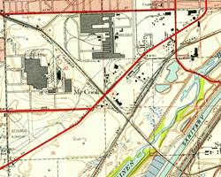
The WPA guide to the state of Illinois published in 1939, describes a tour along Route 66 ("Tour 17") and it has an entry for modern McCook, mentioning the quarry which can be seen in the map on the lower left side, south of the highway. To the north was Stinson Airport between US 66, East Ave and 55th St., also shown in the map, and than nowadays is also a quarry. The entry reads: "Bordering the highway... is a tremendous LIMESTONE QUARRY. From a distance the narrow-gauge trains seem like children's toys scooting about the quarry floor or crawling up the long incline of the crusher."
Sights in this leg of your Route 66 Road Trip in McCook
Drive westwards from Lyons along the 1928-77 Route 66. At 47th St. the highway curves with a NE-SW course and enters an industrial district with manufacturing plants and warehouses. Just before the crossroads with Lawndale Avenue is a classic motel.
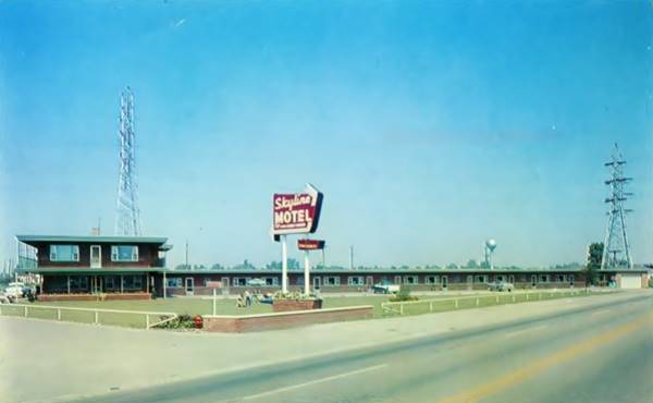
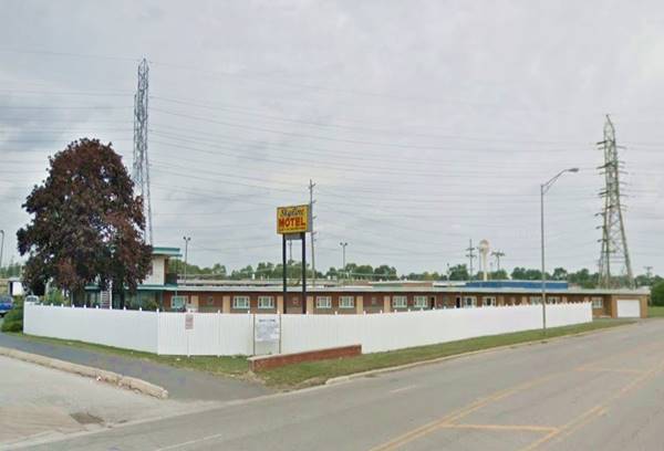
Skyline Motel
To your right at 8136 Joliet Rd. is this 1950s motel. It is temporarily closed after being hit by a tornado in July 2023. Currently owned by the Patel family, the EF1 force tornado ripped off the motel's roof and tore down power lines between Burr Ridge and Stickney. Nobody was hurt.
Skyline Motel vintage 1950s postcard in McCook, Illinois
First Route 66 alignment
Here on the corner the highway meets the original 1926-28 alignment of Route 66 that came from Lyons along Lawndale St. and headed south (left) running towards Summit. It crossed the Des Plaines River and the Chicago Sanitary and Ship Canal, and the old Illinois and Illinois & Michigan Canal. There are no remains of buildings from this period in Summit, or Argo just south of it. The old alignment ends, in a dead end, one-half mile south of the Sykline Motel as the old bridge of Route 66 was removed and the crossing of all these waterways uses the viaduct of IL-171 and the exchange there with I-55. Map with directions
Houdek's Restaurant ⁄ Karen's Smorgasbord (gone)
At the crossroads, on the NE corner of Lawnsdale wa a classic restaurant. It was torn down and now a BP gas station stands on the property.
It began as the Lyons Tourist Hotel Restaurant in 1929 when Joseph Houdek and his son Joseph Jr. opened it as a restaurant with a ballroom and rooms for rent. Its matchcover (pictured below) tells us it was "Famous For Beef - Ribs Chicken & Steak Dinners Route No. 66 At Lawndale Ave. Lyons Illinois - Dancing - Charcoal Bar-B-Q."

Houdek's Bar-B-Q matchcover c.1940s

Karen's Cocktail Lounge matchcover c.1960s
After the death of Joseph (senior) in 1935 his son continued with the business. It changed its name to "Houdek's Restaurant" in the 1940s and to "Houdek's Steak Hosue". The founder's grandson (also called Joseph) took over in the 1950s, Joseph Jr. passed away in 1955 but shortly after Houdek sold the business.

Later it became Karen's Smorgasboard during the 1960s (matchcover above). Its postcard promoted it as follows: "Here's where you will enjoy dining on the original Smörgåsbord, Sizzling Steaks, Lobster Tails, AND FOR THAT LATE EVENING SNACK, DELICIOUS SANDWICHES. COCKTAILS... IMPORTED BEERS, TOO!... SEE YOU, KAREN."

Whoopie Auto Coaster

Whoopee Auto Coaster advert. Source
Here to your right, at 47th St. and Lawndale Ave. close to the crossroads, there was a very unique kind of attraction, a roller coaster built for cars. It had a track built with timber with a wavy layout. Those visiting the park paid a 10 cent admission fee for each passenger in the car (children under 7 went for free), and drove their cars around the track. The undulating roadway was thrilling for the 1920s fun-seekers. The Lyons Whoopee auto track was operated by the Coaster Construction Co., that owned tracks in other cities across America. It closed during the Great Depression and was dismantled. No sign of it appears in the 1938 aerial picture of this area.

Garage (?)
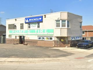
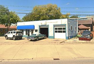
Drive west, on the next block, to your right, on the SW corner with Clyde Terrrace St. is a building mentioned in the Route 66 in Illinois 2012 ⁄ 13 survey as follows: "8240 Joliet Rd., McCOOK... Ca. 1950s... Garage (?)... The building housing "Pomp's Tires" MAY once have been a truck care facility." It appears in the 1951 aerial view of the spot, but not in the earlier 1938 one.
Continue westbound and less than 1⁄4 mile ahead, to your right on the SW corner with Riverside Ave you will spot two landmarks.
Fabulous McCook Neon Sign
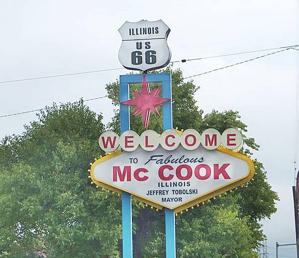
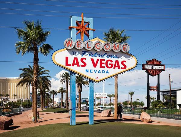
At 5099 Riverside Ave. The "Welcome to Fabulous McCook" neon sign is inspired by the famous "Welcome to Fabulous Las Vegas" sign; in fact it is almost a replica of it. They are very similar, the one in Illinois is crowned by a US 66 shield.
Welcome to McCook neon sign in McCook, Illinois
Original Fabulous Las Vegas, Nevada sign
Listed in the National Register of Historic Places
You can see it at 5200 Las Vegas Blvd. South Paradise, Nevada. The original landmark was designed by Betty Willis and built by Western Neon in 1959 for a local salesman Ted Rogich who then sold it to Clark County, to promote the city.
The sign is 25 feet tall (7.6 m) and is a typical example of space ⁄ nuclear age Googie architecture style, with geometric forms, stars and modernistic designs that were loaded with optimism for the future.
The original Welcome to Fabulous Las Vegas sign in Las Vegas, Nevada
Steak N Egger, former Snuffy’s
Illinois Route 66 Hall of Fame Inductee (2016)
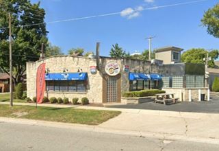
By the sign, on the same corner is a restaurant with a long history dating back to the 1930s. Just ahead, also to your right is the Former Snuffy's restaurant, to your right, at 8408 Joliet Road.
The corner building was built around 1926 and has a characteristic design that uses Joliet limestone obtained from the quarries in the area. The first diner here opened in 1929 to cater to the local industrial plant workers and also the truckers driving along Route 66. It is said to have had gambling rooms in the back.
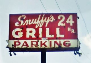
In 1969 the place was Nick Stavropoulos and George Adamopoulos purchased the property and moved their Snuffy's Grill from its address further down the highway, at 8606 Joliet Rd. to this one. Snuffy's closed in 2010.
It was purchased in 2012 by a Chicagoland-based restaurant group established in 1955, Steak N' Egger. They preserved the original building and decorated its interior with 1950s vintage decor. Below is the now gone Snuffy's neon sign and a view of this classic diner, click on them for their street views.
Old Gas Station
On then corner adjacent to the restaurant (NE - Egander Ave and Route 66) is an old c.1940s box-shaped gas station with two service bays. No canopy or sign of pumps, now it is a repair shop.
Matilda's Bar Site
The Outlaws Motorcycle Club, was founded by John Davis in McCook in 1935 as the McCook Outlaws Motorcycle Club. This event is said to have taken place "out of Matilda's Bar on Route 66 in McCook , Illinois , outside Chicago." The organization changed their name to the Chicago Outlaws in 1950. It has over 3,000 members and more than 440 chapters in over 40 countries around the world.
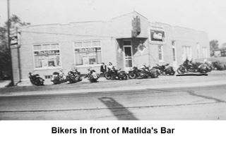
There are many books on the Outlaws Bikers Club but none of them give an address for Matilda's. We have checked the aerial photographs of 1938 looking for a corner building similar to the one depicted abov and we believe that it is the corner building opposite the old gas station, at 8428 S Joliet Rd., on the NW corner of Egandale Ave and Route 66.
The building was built around 1913 and has many similarities with Matilda's. We mention them below (the numbers correspond to the image):
- The side of the building has the same sequence of openings: narrow window, door, wide 3-panel window, door, 2-panel window
- The corner entrance has been closed off with boards, notice the building is a brick building, this is an addition
- Two basement windows made of glass bricks, with a wide skirting along the sidewalk
- The two windows facing Route 66 have been made smaller but the original wide window sills are still there
- The western side of the building has an angled wall and a pigeonhole corner (the intermeshed bricks) as a decorative element

Continue West for the final part of McCook
The Old Route 66 highway passes under IL-171, curving softly. After the overpass, to your right is the JC's Ristorante at 8650 Joliet Rd. It is owned and ran by Joe Cistaro and has been here for the past 30 years. The original building on this site was the creation of Fernando "Fred" Vitorio Collecchia (1920-2015), born in Italy, who came to the U.S. at the age of 12, with his family. He served in the U.S. Army during WW II and settled here in Lyons - McCook area. He opened several restaurants here over the course of the years, the Hi 66 Drive inn at 4400 Prescott Av (Route 66) in Lyons, Fernando's Restaurant and Fred's Patio Lounge in the 1960s, and his final restaurant was Fred's Folly in 1985. The he made a detour in 1975 and opened the Homestead in Middlebury, IN and started his second family. He found his way back to McCook in 1985 and opened his last restaurant Fred's Folly Bar and Grill, at this site (Street view).
Closed Section of Route 66
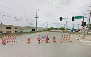
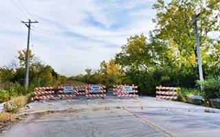
The highway runs through an industrial neighborhood. Ahead after the overpass across the railroad tracks to your left is the vast quarry of Vulcan Materials Company, and just ahead Route 66 has been closed to traffic. You will have to take a detour at the fork and head west along 55th Street to bypass the closed section. We marked the gap with a green line in our interactive map.
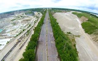
Aerial view, thumbnail from the "Route 66 Off Limits" video by Roamin' Rich
In 1998 a one-mile section of the highway buckled and broke. This disrupted traffic so the road was closed and traffic re-routed along a detour (55th St. and East Ave.)
The quarry that is located on both sides of the highway and is operated by Vulcan Materials Co. (the second largest mining company and producer of aggregate in the world), had undermined the bedrock foundations of Route 66.
The road ended up located on a narrow strip of limestone, resembling a long ridge, with sheer drops on both sides into the depths of the quarries. Definitively closed as it was too dangerous, the Illinois DOT filed a suit against Vulcan that same year stating that Vulco had mined limestone too close to the highway, damaging it. The lawsuit was settled by Vulcan who payed $40 million to the state of Illinois, though they didn't admit any liability.
Below are two views showing the northern and southern tips of the closed US 66 segment (click on them for a St. view):
Ahead, along the detour around the quarry, to the right on 55th Street is the enormous Diesel Locomotive Plant (formerly "Electro-Motive Diesel").
Former Electro-Motive Diesel
9301 W 55th St. General Electric built the plant in 1935 to manufacture diesel locomotives. It also provided jobs here during the Great Depression. In 2005 GE sold it to a group of investors who formed the Electro-Motive Divison (EMD), that was in turn sold to Caterpillar as Progress Rail.
The plant produced over 50,000 diesel-electric locomotives selling them in more than 100 countries.

The postcard from the 1940s depicts both the plant and a Denver Zephyr engine. The company built them for the Chicago, Burlington and Quincy Railroad who used them on the 1,109 miles-long (1,785 km) service from Chicago to Denver, Colorado from 1936 to 1973.
Stinson Airport site
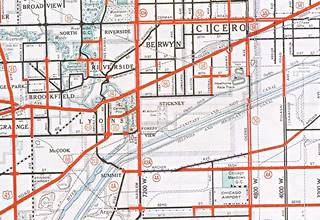
1934 map of Route 66 in Chicagoland. Source
Click map to enlarge
At East Ave. the detour takes a sharp left heading south, skirting the quarry along its western side. Ahead it reachs Historic Route 66 (Joliet Rd.) where you must turn right to continue your journey. Here, to your left, occupying the area where the quarry's pit is located (between 55th, the closed US66 segment and East Ave), was the site of an airport. You can see it in the map on its lower left side.
It started operating around 1930, with two sod runways 1,000 feet long, and three hangars. By the 1940s a third longer runway with a crushed stone surface had been added. The quarry company that owned the land closed the airport in 1958 and has been excavating the area since then.
On July 6, 1930 a tragic event took place at Stinson Field when Mary Fahrney, a 20-year-old novice parachute jumper got her parachute entagled in the wing of the plane she jumped off. She dangled for several hours 1,000 feet above the ground while several attempts to rescue her failed. Finally, a WW I pilot, Bruno F. Schustek (1899-1930) managed to free her chute and she landed safely, but Schustek fell to his death. The USGS honored him, the Hero of Stinson Airport Tragedy, by naming a nearby pond (map) in Burr Ridge, close to Route 66 with his name.
Continue your Road Trip
This spot marks the end of this leg of your road trip through McCook. The highway continues west and enters Countryside
Sponsored Content
>> Book your Hotel in Chicago

Credits
Banner image: Hackberry General Store, Hackberry, Arizona by Perla Eichenblat
Jack DeVere Rittenhouse, (1946). A Guide Book to Highway 66.


