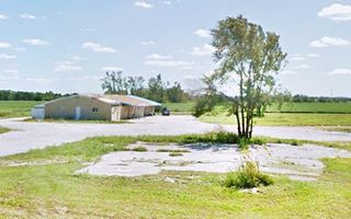
Route 66 in Braidwood IL
Index to this page
About Braidwood IL
Facts, Information and trivia
Elevation: Elevation 574 ft (175 m). Population 6,124 (2024).
Time zone: Central (CST): UTC minus 6 hours. Summer (DST) CDT (UTC-5).
Braidwood is a city located on Route 66 and ALT US 66 in Will County in northeastern Illinois.
History of Braidwood
Illinois' first inhabitants were the Paleoindians that reached the area at the end of the last Ice Age around 11,000 years ago.
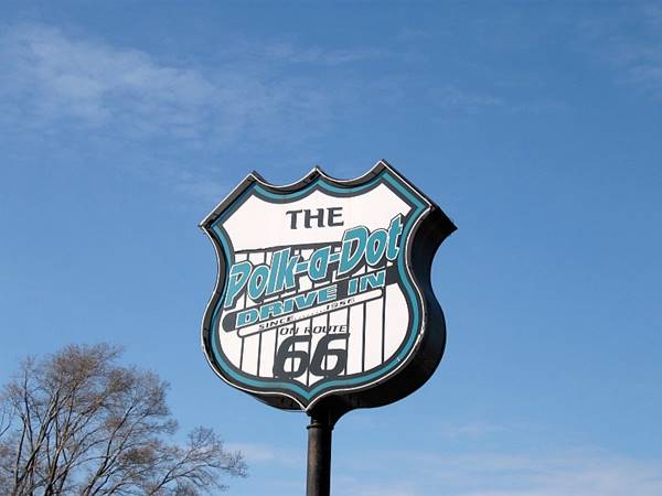
Polk-A-Dot Neon Sign in Braidwood, Illinois
The French in the 1660s explored the Great Lakes as well as the Illinois and the Mississippi Rivers. They met the Illinois and Kickapoo people in what would become Braidwood. France lost the territory to England after a peace treaty in the mid 1700s, but shortly after, it became a part of the U.S. and was organized into a Territory which in 1818 became the state of Illinois.
In 1836 Will County was created; it was named after Dr. Conrad Will who had been a member of the first Illinois Constitutional Convention and later a member of the Illinois Legislature.
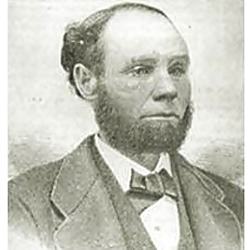
Portrait of James Braidwood. Source
Some settlers reached the area in the 1830s and the railroad passed through it in the early 1850s but the region economy greww after coal was discovered in 1864.
William Hennebry found coal while digging a well on Thomas Byron's farm in 1864. Being close to Chicago (a great market) was key to its success, and as it was beside the railroad, built in 1853, it also became a source of fuel for its steam engines, replacing wood.
Scotsman James Braidwood (1831-1879) was a steamship engineer who migrated to the U.S. in 1865, and sunk the first mining shaft. Coal brought a boom to the area and towns sprung up to become the home of thousands of immigrant workers.
The town and its post office were established in 1867. Work conditions were though and hazardous; a strike of mine workers in 1877 resulted in the governor sending 1,300 troops to Braidwood.
The name: Braidwood
Named for James Braidwood whose surname like Broadwood, Bradwood, and Braiduode is a Scottish one, from the village of Braidwood in the parish of Avondale, in the county of Lanarkshire. Its name means "Broad Wood."
Population grew to 5,000 in 1880. But then coal from southern Illinois was discovered and it had thicker veins which made it cheaper to dig it out. The outpud in Braidwood declined, and mines started closing (1916: Godley, 1918: Torino, 1923: South Wilmington), though strip mining stepped in, cheapening the process, and coal was produced until the 1970s, it had lost its economic importance.
When Route 66 was created in 1926 it used the alignment of State Hwy 4. It became US ALT 66 in 1939 when a new US 66 was built through the town on the north side of the railroad.

Hotels and Motels in Braidwood
There are several hotels close to Braidwood and in the neighboring towns along Route66.
>> Book your Hotel in neighboring Wilmington or Dwight
Find More Accommodation near Braidwood along Route 66
Below you will find a list of some of the towns along Route 66 east and west of this town; click on any of the links to find your accommodation in these towns (shown from east to west):
Along Route 66 in IL
- Hotels in Illinois
- Route 66 Starting point ▸ Chicago
- Lockport
- Willowbrook
- Bolingbrook
- Plainfield
- Romeoville
- Joliet
- Wilmington
- Dwight
- Pontiac
- Chenoa
- Normal
- Bloomington
- Atlanta
- Lincoln
- Springfield
- Raymond
- Litchfield
- Staunton
- Williamson
- Hamel
- Edwardsville
- Collinsville
- Troy
- Glen Carbon
- Pontoon Beach
- Granite City
- East St. Louis
West in Missouri
- Hotels in Missouri
- Florissant MO
- Bridgeton MO
- St. Louis MO
- Kirkwood MO
>> See the RV campground in Braidwood and also nearby in Joliet
The Weather in Braidwood
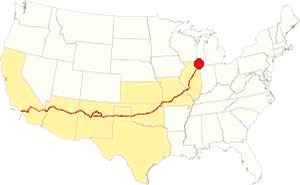
Map showing the location of Braidwood, Illinois on U.S. 66
The climate of Braidwood is a humid continental one with all four seasons distinctly represented; summers are hot and humid, spring is wet and cool, autumn is mild and pleasant while winters are quite cold.
Temperatures: The average winter (January) high is 31°F (-0.3°C); and the average low is 17°F (-8.6°C). The summer average high (July) is 84°F (29°C) and the average low is 64°F (17.7°C).
Rainfall ranges from 3 to 4.3 (78 and 110 mm) inch monthly from April to November, and falls to a drier 1.7 in. (28 mm) the rest of the year. On average, Braidwood gets 36.82 inches of rain each year (936 mm).
Snowfall: on average, 28 inches (71 cm) of snow falls each year. The first snow falls in Nov. and the last (less than 1⁄4 inch or 8 mm) falls in April. There is usually no snow between May and September.
Tornado risk
The county around Braidwood gets some 5 tornado strikes every year.
Tornado Risk: read more about Tornado Risk on U.S. Hwy 66.
Map of Route 66 in Braidwood, IL
>> Our Custom map shows the alignments of U.S. 66 in Braidwood.

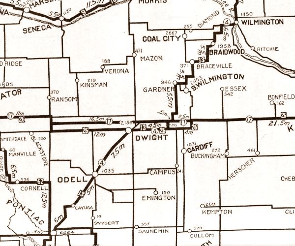
1928 Illinois State roadmap (see State Hwy 4A). Source
Click map to enlarge
Illinois funded its state highway system by issuing a bond in 1918, this resulted in SBI 4 (State Bond Issue) highway number 4 being built along the former "Pontiac Trail" from Chicago to St. Louis. By 1923 it had been totally paved and in 1926 Route 66 was created and aligned along it. In the area where Braidwood is located, the first IL-4 had a zig-zagging course that was straightened out when it was paved.
The map below was published in 1924, two years before Route 66 was created. It displays the "Auto Trails" or roads that were suitable for cars. The ones near Braidwood are marked with numbers: as "13" and "26" with white numbers inside black squares, these are the "trails", standing for "Mississippi Valley Highway" and "Blue Grass Road" respectively. The number "4" inside a white circle is what originally was State Highway 4.
The Route 66 alignments in Braidwood
US 66 from 1926 to 1939
The original Route 66 is present IL-53, running along the eastern (or southern) side of the railroad from Braidwood into Gardner. It is marked with a green line in our custom map
US 66 from 1940 to 1956
In 1939 the highway was realigned north of Braidwood, creating a faster and far straighter road that ran through Plainfield and bypassed Joliet and Wilmington. This new highway is marked with a yellow line in our custom map
It continued west, with a completely new aligngment built along the north side of the railroad, parallel to the original roadway but with the tracks separating both alignments. It is marked with a blue line in our Custom map.
This completely new highway from Plainsfield to Gardner was designated as U.S. Highway 66 and the "old" roadway was designated as Alt US 66.
Alt US 66 from 1940 to 1967
The original alingment of Route 66 created in 1926 between Gardner and Romeoville, via Joliet therefore became the Alternate U.S. 66 highway and remained in use until it was delisted in 1967. The Alternate 66 alignment was eliminated in February 1967 and replaced by Illinois State Highway 53 from Welco Corners to Gardner.1
US 66 from 1956 to 1977
In 1956 US 66 was moved further west to a completely new alignment with four lanes, a divided highway (lacking overpasses though), that bypassed the towns from Braidwood to Gardner. Route 66 shared the road with the newly created freeway I-55. Later updating of the freeway standards eliminated the original 4-lane 66 now overlaid by I-55. See the violet line in our Custom map.
Alternate US 66
In 1959 the American Association of State Highway and Transportation Officials (AASHTO) came up with the "Alternate" designation.
It was to be used to designate a highway that branches off from the main one, passing through certain cities and then links up with the main route again.
If the Main and alternative routes followed a similar course, the better built or shorter highway would be the one marked as "Main", while the other would become the "Alternate" one.
There are only six places along Route 66 where an Alternate 66 alignment existed: From East to West they were this one close on Route 66 into Chicago, Carthage MO, the one in Joplin MO, Oklahoma City, Alt 66 in San Bernardino, California, and the one leading into Los Angeles CA.
Route 66 is a Historic highway and has also been designated as a National Scenic Byway and an All-American Road in the state of Illinois.
The Route 66 alignments near Braidwood
Description and interactive maps of US 66.
- Pontiac to Springfield (next)
- Chicago to Pontiac (Braidwood's)

Braidwood's Route 66 Landmarks and Attractions
What to see in Braidwood
US 66 in Braidwood: historic context
In 1946 Jack DeVere Rittenhouse published his "Guide Book to Highway 66" in which he describes the whole road from Chicago to Los Angeles. He mentions Braidwood:
...stores; gas; cafes... you pass between huge heaps of dirt and 'slag' -refuse from the coal pits which made this a boom area at one time. Rittenhouse (1946)
He mentions that it was famous for the "Peter Rossi" macaroni plant, that opened in 1876 and in 1946 was still operating in the same factory. On the outskirts of Braidwood he noted that there were "... a few tourist cabins" on the right and some old mine structures to the left.
Driving Route 66 in Braidwood a City Tour
Coming from Chicago, you can reach the town either along the 1939-77 Main U.S. 66 from Plainfield, or the 1926-39 US 66 & 1940-67 ALT US 66 from Wilmington. Both alignments converge, one on each side of the railroad 1.7 miles east of Braidwood (and you can drive from one to the other either at Coal City Rd. 1 mile east of this point) or on E Main St. in downtown Braidwood.
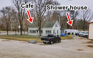
Former Cafe, Cabins and Gas station
Coming from Plainfield, which was the course taken by Ritten house in 1946, he mentioned that 21 miles south of the town was "Gas station. Another gas station with a cafe and a few cabins at 22 mi." The first of these two sites has vanished, you can see it in this 1952 aerial view, a house with a white picket fence stands on the property. When it was cut off from the main 4-lane alignment in the 1950s it went out of business (map marking the spot). The second site has survived. It is located on the NW corner of Stripmine Rd. and former Route 66 (Il-129). The aerial view from 1939 shows it clearly.
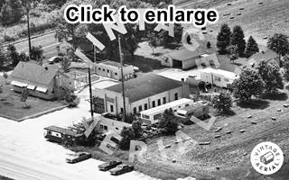
1975 aerial photo. Cabins, Cafe, gas Station. Near Braidwood.
Source. Click to enlarge
The Image above shows the Cafe on the corner and behind it is a cement block structure that was the campground's shower house. The gas station is gone. There is a surviving cabin on the property.
If you are coming from Wilmington, this is the map with directions to get to the old cabins and cafe. To reach Braidwood we recommend using present Hwy 53 (which used to be ALT US 66): see this map with directions.
Slag heaps
The coal mining refuse or slag mentioned by Rittenhouse was evident south of town, on its northern side there were large scars with ditches and low rubble heaps, but in town, and south of it there were conical heaps of dirt, coal and stone. These have been remedied since the late 1990s by removal, grading, and infill of old mine shafts.
To your right at 222 North Front St., after the McDonalds, is the famous Polk A Dot Drive In
Polk-A-Dot Drive-In
Illinois Route 66 Hall of Fame inductee
This restaurant opened in 1956 by Chester "Chet" Fife, from neighboring Wilmington. He originally ran a sort of food-truck selling ice creams and hot dogs, that he parked in Braidwood to cater to those traveling along Route 66. The current restaurant got its name (Polk-A-Dot Drive In) from a school-bus covered with multicolored polka dots that Chet used as is sales point. In 1962 he moved to its current location and built a drive-in that had a kitchen and could offer fries and cooked meals.
Chet sold his business to Judy Dixon Chinsky in 1972, who ran it with her husband Daniel. The sold it in 1978 to Angelo and Pat Bianchin. But, weird things happen, and in 1987 they bought the Polk-A-Dot again! in a partnership with Judy's brother John Dixon and his wife Cathy.
The restaurant has a retro look that takes you back to the 1950s. It even includes glass bricks from the 1950s tavern and restaurant that Judy and John's parents, Kathryn and John Sr. had owned on Main Street in Braidwood.
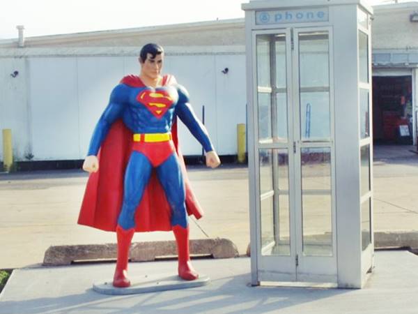
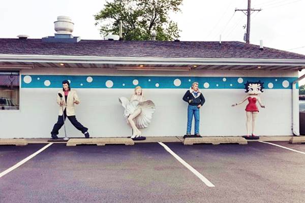
It has a drive-up window and many fiberglass figures that include Superman, Elvis Presley, Marilyn Monroe, Betty Boop, among others.
For those looking for a 1950s-styled diner to enjoy some burgers, malts and fires, this is the place to stop and eat.

Blues Brothers statues, Polk-A-Dot Alt 66. Source
Life-sized statues:
Elvis, James Dean, Marylin Monroe and, Betty Boop, more life-size statue at the Polk-A-Dot in Braidwood, Illinois
Braidwood "Zoo"
Route 66 Kitsch
Ahead, on the next block to your left at 155 N Front St, is a wacky Route 66 stop, a weird zoo
The Braidwood Zoo consists of a steel fence enclosing an assortment of "animals" (a pink elephant, a cow, steer, polar bear, and giraffe) that were created by artist Jack Barker who had his workshop nearby, in Essex, IL. He passed away in 2012, but his work survives him on Route 66.
On the next block before crossing the railroad to the western side of town, look towards the left. On the corner where the Circle K gas station is located, was the site of a historic Macaroni plant.
Peter Rossi Macaroni Plant (gone)
Peter Rossi Sr. had learned the trad of macaroni manufacturing in his hometown close to Torino in Italy. In 1878 he migrated from Italy to America. He worked in Braidwood as a weighman at a mine, then moved to Chicago to work at a macaroni-producing plant. Shortly after he returned to Braidwood where he opened a hardware store. In 1886 he opened his Peter Rossi Macaroni Factory" on Fourth St. Shortly after he moved his store and office to the remodeled former Broadbent Hotel on the NW corner of B street and Main St. (now Route 66 and Main St). His factory according to the 1907 Sanborn Map shows the factory on the corner of French St. and Front St. This plant is pictured below, notice the road signs (enlarged in the inset) showing the directions to Joliet and Gardner along Route 66, and Kankakee for those reaching US 66 along Main St. from the west.
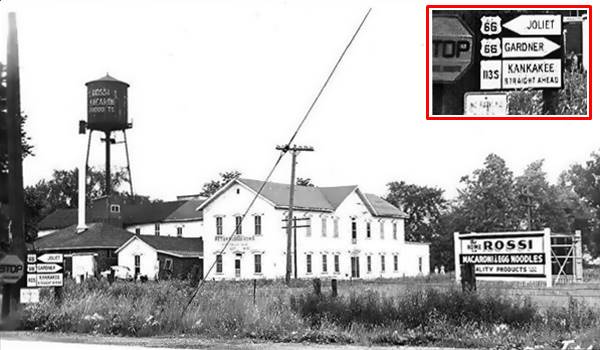
The company grew and soon Rossi and Sons Macaroni Factory made Braidwood known as "The Little Macaroni Capital of the Big Macaroni World," their brand was "Lincoln" and known throughout the U.S.
Peter Rossi passed away in 1918, but his sons continued the business and as entrepreneurs, developed others in Braidwood and in other cities. The family sold the business in 1969.
Crossing the railroad, you will reach the 1939-56 Route 66 alignment that here used B Street to cross the downtown district. In 1956 it was described as follows:
As you cross the railroad to its western side along Main Street, Old timers will hardly recognize the Eastern en-trance to the city's Main Street from the depot side. The only familiar brick building remaining as of 1956 is the old Broadbent Hotel, now in disuse.
Forming the new entrance are the following newstructures: (1) the attractive Sinclair Gas and Service Station of glazed tile on "B" and Main Streets, built in 1939, by the late Stephen Rossi; (2) To the East facing Route No. 66 is a brick restaurant building, erected by Mr. Rossi in 1940 and operated by Weitz Bros., famous restaurateurs; (3) the Rossi Motel, a 16 unit brick building, one ofthe modern motels built by Peter and John Rossi, in 1951. On the South side of Main Street is the new two story brick structure, built in 1951 by Ernest Barnett and Sons, Francis, James, Kenneth and Raymond, containing restaurant upstairs and lounge on main floor... Modesto J. Donna, The Braidwood Story (1957)
We describe these buildings below. The Broadbent Hotel was torn down in the early 1970s, the Casey's on Mitchell and Main stands on the property.
Rossi’s Service Station
To your right, on the NW corner of Route 66 and 100 N Washington St
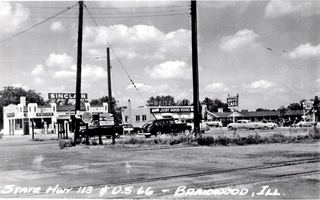
This was Peter Rossi's eldest son Stephen's service station; built in 1939 on what was then the new alignment of Route 66. It originally sold Sinclair Oil gasoline as you can see in the image below.
It is built in Art Deco style which flourished between both World Wars (1914 - 1940). It was a symbol of wealth, luxury and elegance that adopted symmetry, rich colors and bold rectilinear geometric shapes to exalt the technological progress of the early twentieth century.
Before the Sinclair, this spot had been the site of Anderson Oil company's Braidwood plant. A tragic explosion took place here on the day after Thanksgiving in 1931 killing Alexander McElroy, aged 28.
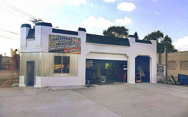
The gas station was acquired by the regional tire chain Lucenta Tire in the 198's, then it became M & R Tire and Auto and now it is the Cossroads of America Car Truck and Tire Center and Auto Service.
Vintage photo Rossi’s Service Station in Braidwood, Illinois
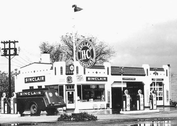
As you can see below, even though the office's large glass windows have been modified and made smaller and that the clock above the door has gone, the tiled parapets and overall appearance has not changed:
The former Rossi gas station nowadays
After Stephen's death his sons Peter B, and John took over management of the station and adjacent motel.
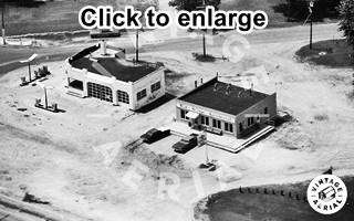
1980 aerial view former Rossi station and Weitz Cafe.Source.
Click image to enlarge.
Weitz Cafe
Next door, to the right is the former Rossi restaurant, at 110 N Washington St.
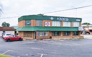
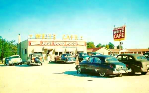
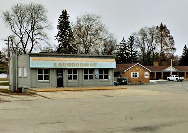
The café's sign read "Just Good Food". As you can see in the "Then and Now" sequence below. Stephen Rossi opened it in 1940 and the building has survived unchanged. Its four windows still face the highway, but the individual window awnings have been replaced by a single longer one.
Rossi quit the restaurant business selling it to the Weitz Brothers, Herb, Frank, and Conrad, who lived in neighboring Morris where they opened their first cafe in 1928. After serving in the Army during WWII, the brothers leased the empty building from John and Patsy Rossi and opened a second cafe on Route 66 that could seat 35 customres. They were always fully booked and they prepared most of the food in Morris. After the highway moved in the mid 1950s to where I-55 now runs, the Weitz brothers sold their business in Braidwood. Herb and Conrad kept their cafe in Morris till they retired in 1971. Frank opened another restaurant in Peoria.
Vintage postcard Weitz Cafe in Braidwood, Illinois
The same place nowadays shows it becama a laundromat:
Rossi's Motel - Now the Braidwood
The Rossi's complex also included a motel, which can be seen in both of the Weitz Cafe pictures above (to the right). IT is located on the north side of the former café at 120 N Washington St.
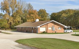
The National Park Service described it as one of the few 1935-1958 Motel Buildings Remaining on Route 66 in Illinois. It is a U-Shaped woodframe building, with one story and an end gable roof. Dates back to 1950. Originally named "Rossi's Motel", now it is the Braidwood Motel, and the Original neon sign still stands; its postcard says "16 Modern Brick Units - Insulated - Tile Floors - Tile Baths ... Beauty Rest Mattresses - Box Springs... Cafe and Service Station on Grounds" below are some "Then and Now" views
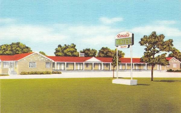
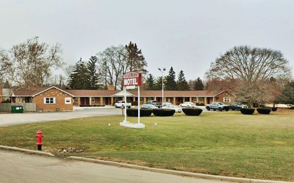
This motel was, a one-hundred thousand dollar business (in those days), "the largest and best in Southwestern Will County."
Barnett
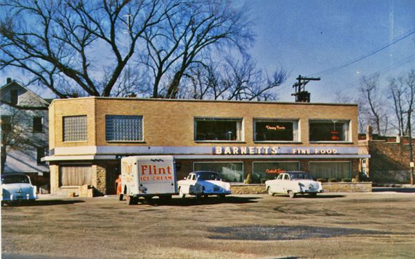
The final building on the crossroads was on the south side of Main Street, west of the gas station. The two story brick building is still standing. It was built in 1951 by Ernest Barnett to house is business, Barnett and Sons, (Francis, James, Raymond and Kenneth) with a restaurant and cocktail lounge. Kenneth (1914-2007) ended up owning and running it with his wife Lorraine for many years-
Tourist Cabins (gone)
Rossi's Park c.1930s. Credits
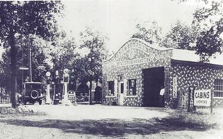
Rittenhouse mentions that "Leaving Braidwood you pass a few tourist cabins (Right);" and Modesto J. Donna in The Braidwood Story (1957) says that Rossi "had built the famous Rossi Dance Pavilion, south of the city, on 66A." In her book Route 66: The Highway and Its People,(1990), Susan Croce Kelly reports that Rossi opened his Dance hall in 1927 and that it burned in 1935, he had cabins and a few gas pumps by the gas station. He didn't rebuild it; the end of Prohibition in 1933 was closing the Dance Hall era, taverns and bars would reign in the post-Prohibition period. He moved downtown and built the Sinclair. The image shows it in the 1930s, with a sign reading "Rossi's Park" and cabins with showers, three pumps stand in front of the building and a grove of trees surround it. Based on the time frame it was located on the only US 66 alingnment that existed from 1927 to 35, later the Alt 66, current IL-53. But nothing remains, it has vanished.
These are the last sights along the alignments from 1926 to 1956 in Braidwood, but on the later four-lane US 66 highway (1956-77 alignment) now overlaid by the freeway, there are more classic sites to visit.
Braidwood's U.S. 66 (1956-77) sights
Sun Motel (Braidwood Inn)
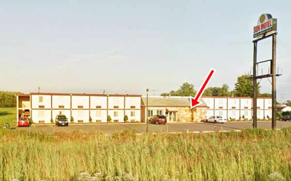
Drive west along Main Street till it ends at the Freeway and turn south along S. Hickory St. to your right at 140 S Hickory St. you will see the back part of the 1960s Sun Motel, its main entrance faces the freeway.
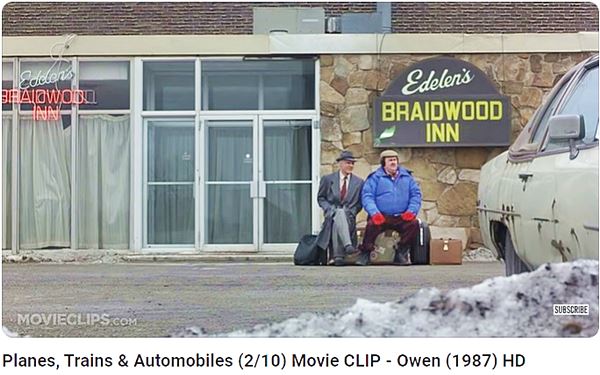
Ths Sun Motel appeared in the 1987 movie starring Steve Martin and John Candy (Planes, Trains and Automobiles), where the two characters who are trying to get to Chicago en up in Wichita Kansas. Below the two actors are sitting in front of the stone facade of "Edelen's Braidwood Inn", as you can see in the image further down, that same facade is still there (red arrow) but no sign appears on it.
Sun Motel (Braidwood Inn) movie scene in Braidwood, Illinois
Sun Motel (Braidwood Inn) nowadays in Braidwood, Illinois
Davito's Motel
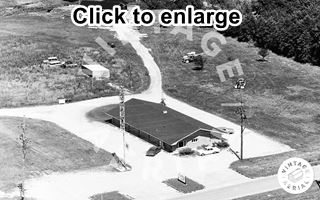
1971 aerial photo Davito's Motel, Braidwood, Il. Source
Continue southwards along S. Hickory St. you will pass by a bar, The Fuel Saloon, that formerly was Lolly's Steak House in the late 1960s. Turn left when you reach W. Kennedy Rd. just ahead, to the left is another motel. To the east of the gas station just beside the storage company.
The gas station was a Standard Station ice-box style, from the 1950s (1971 aerial view).
At 1150 W Kennedy Rd. (in those days Reed Rd.) Braidwood. The twelve room motel opened around 1961 as Davito's Motel. Its postcard tells us it had "Free TV - Showers and Bath... Wall to Wall Carpeting - Soundproof Rooms Restaurant and Service Station open 24 hours Daily... Hosts Mr. and Mrs. Chester W. Davito and Family." Now it is an apartment complex.

Davito’s Motel, Braidwood, Il. Source
Sands Motel (gone)
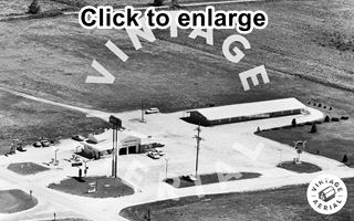
1971 aerial photo Sands Motel, Braidwood, Il. Source
Across the street, on the south side (SE corner of Kennedy Rd. and I-55's eastern Frontage Rd. - Kankakee Rd.) there was a motel, the Sands, with 16 units. You can see it in the 1971 aerial view below, which includes the Arco station that stood next facing Kennedy Rd. The aerial image looks towards the south. These buildings have all been torn down, the motel in 2016. All that remains is the concrete drive of the old Arco station.
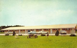
Sands Motel 1960s postcard, Braidwood, Il. Source
Side Trip towards Coal City
You can take a short side trip (5.4 mi round trip), shown in this is a map with directions, to visit the Diamond Mine Disaster marker.
1883 Diamond Mine Disaster marker
Historical Marker
2300 Main St. (Illinois Route 113), Diamond. The marker is on the north side of Main Street in Diamond Park, and it honors those who perished in the mine disaster. The Marker's text tells us about the sad events that took place in 1883.
The marker reads:
The Diamond Mine of the Wilmington Coal Mining and Manufacturing Company, located near Braidwood on the Grundy-Will County line, was the site of a major mine disaster in Illinois.
The mine was on a marshy tract of land that had no natural drainage. At midday of February 16, 1883, the east side of the mine collapsed from the weight of melting snow, ice, and heavy rains. An alarm was sounded, and miners who were near the escapement shaft hurried to the surface. The main passage to the shaft flooded rapidly, and the weight of the water sealed the ventilation doors in the tunnels. Escape became impossible, and rescue attempts were futile.
Other mines in the area suspended operations, and their workers helped build a dam on the site. For thirty-eight days seven steam pumps removed water from the mine. Volunteers descended the shaft on March 25, and the first bodies were recovered on March 26. The recovery effort was hampered by accumulations of debris and gas as well as by falling rock. Several days later the mine was sealed with the remaining forty-six bodies entombed.
Numerous men and boys died in the disaster; two were thirteen years of age, and two were fourteen. Contributions for families of the victims were received from across the United States and totaled more than $42,000, including $10,000 appropriated by the Illinois General Assembly. In 1898 the United Mine Workers of America placed a monument at the site.
Continue your Road Trip
Your Route 66 Road Trip across Braidwood ends here, now head west to visit the next town, neighboring Godley use ALT 66 to reach it, the later 1939-56 US 66 is cut at the missing bridges south of Braidwood.

Sponsored Content
>> Book your Hotel in Chicago

Credits
Banner image: Hackberry General Store, Hackberry, Arizona by Perla Eichenblat
Jack DeVere Rittenhouse, (1946). A Guide Book to Highway 66.


