Route 66 in Plainfield IL
Index to this page
About Plainfield IL and Route 66
Facts, Information and trivia
Elevation: Elevation 571 ft (174 m). Population 47,549 (2024).
Time zone: Central (CST): UTC minus 6 hours. Summer (DST) CDT (UTC-5).
The Village of Plainfield is located on the 1940-1958 Route 66 alignment in Will County, Northeastern Illinois.
History of Plainfield
The French explored the Great Lakes, Illinois and the Mississippi Rivers in the 1660s. Here they met the Illinois, Potawatome, and Kickapoo Native American people. In the mid 1700s France ceded the land to England after its defeat in the Seven Year War. Britain lost it to the U.S. during the American Independence War. The territory incorporated to the Union as the state of Illinois in 1818.
At that time, there was a settlement of Potawatomie Indians along the DuPage River close to where Plainfield is now located. In the 1820s James Walker settled by their village and his father-in-law, Rev. Jesse Walker evangelized the natives. In 1828 James staked a claim and built a sawmill. In 1830, the first settlers at "Walker's Grove" arrived, they were Reuben and Betsey Falagg.
The village was platted by Chester Ingersoll in 1834 as "Plainfield". In 1836 Will County was created and it included the area around Plainfield.
The name: Plainfield
At the end of the last Ice Age, what is now the area around Plainfield was the bed of Lake Wuponsee, a glacial melt lake that drained into the Illinois River. It dried up, leaving a very flat (or "Plain") landscape.
This verdant prairie that extended west of the thickly wooded DuPage River was indeed a "Plain Field", and it gave the village its name.
The Illinois & Michigan Canal was built in the 1840s and it was located east of Plainfield. This region evolved into a farming community and supplied produce to the flour mills and industries located in the communities along the canal.
Lincoln Highway
The transcontinental Lincoln Highway was created in 1913 and it passed through the town. It became the first paved transcontinental highway that linked New York with San Francisco.

Accommodation near Plainfield
> > Book your hotel in Plainfield
Find More Accommodation near Plainfield along Route 66
Below you will find a list of some of the towns along Route 66 east and west of this town; click on any of the links to find your accommodation in these towns (shown from east to west):
Along Route 66 in IL
- Hotels in Illinois
- Route 66 Starting point ▸ Chicago
- Lockport
- Willowbrook
- Bolingbrook
- Plainfield
- Romeoville
- Joliet
- Wilmington
- Dwight
- Pontiac
- Chenoa
- Normal
- Bloomington
- Atlanta
- Lincoln
- Springfield
- Raymond
- Litchfield
- Staunton
- Williamson
- Hamel
- Edwardsville
- Collinsville
- Troy
- Glen Carbon
- Pontoon Beach
- Granite City
- East St. Louis
West in Missouri
- Hotels in Missouri
- Florissant MO
- Bridgeton MO
- St. Louis MO
- Kirkwood MO
>> See the RV campgrounds in Chicago or in Joliet and Braidwood
The Weather in Plainfield
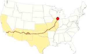
Map showing the location of Plainfield, Illinois on U.S. 66
The climate of Plainfield is classified as humid continental and has clearly marked seasons with hot and often humid summers, cool and wet springs, mild falls and cold winters.
Temperatures: Average high in Jan (winter) 31°F (-0.3°C) and the average low is 17°F (-8.6°C). Average high in Jul (summer) 84°F (29°C), with an average low of 64°F (17.7°C).
Precipitation: Rainfall is between 3 and 4.3 (78 and 110 mm) inch per month between April and November, falling to around 1.7 in. monthly (28 mm) during winter. Average rainfall is 36.82 inch (936 mm).
Snow: The city gets 28 inches of snow per year (71 cm), with the first snowfall usually taking place in November and the last one happening in April (with less than 1⁄4 inch or 8 mm). You shouldn't see snow from May to September.
Tornado risk
The 1990 F5 Tornado
On August 28, 1990, the "Plainfield Tornado", which was very powerful F5 tornado struck Plainfield, Crest Hill and Joliet, killing 29 people and injuring hundreds.
Will county around Plainfield experiences some 5 tornados each year.
Tornado Risk: read more about Tornado Risk on US 66.
The Maps of Route 66 in Plainfield
>> Our Custom map shows the different US 66 alignments in Plainfield.
The map below was published two years before Route 66 was created, it shows the different Auto Trails in the area near Chicago. The trails were roads that were fit enough to be driven by cars (not necessarily paved, but with a decent roadway). Those marked with numbers in black boxes are named trails, for instance "34" was the "Lincoln Highway" and you can see it running into Joliet and tthrough Plainfield. The numbers inside white circles were the state highways: the "4" inside a white circle is State Highway 4. It runs through Lemont and Lockport to Joliet to the east of the Des Plaines River, it would be the first alignment of Route 66 in 1926.
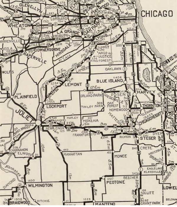
Route 66 and Plainfield
When Route 66 was created in 1926 it didn't pass through Plainfield, instead it ran further east, from 1926 to 1928 from Lyons to Joliet through
Lockport, along the eastern side of the Des Plaines River and the Illinois & Michigan Canal (See the bordeaux line in our custom map).
Below are some maps of that period showing the state highways and U.S. highways click on the maps to enlarge them.

1927 Chicagoland map. Source

1928 Illinois State roadmap (see State Hwy 4A). Source
The highway was realigned in 1928 along the western side of both waterways, through Romeoville (violet and pale blue lines in our custom map).
Route 66 Realignment (1940 to 1956)
But, in 1939 a straighter course was built for Route 66 and this one went into Plainfield along former State Highway 126 (red line in our custom map). Running from Welco Corners to Plainfield.
It then turned sharply and continued westbound with a completely new aligngment in a straight line towards Braidwood (yellow line in our custom map)
This completely new highway was designated as U.S. Highway 66 and the "old" roadway was designated as Alt US 66.
Alt US 66 from 1940 to 1967
The original alingment of Route 66 created in 1926 between Gardner and Romeoville, via Joliet therefore became the Alternate U.S. 66 highway and remained in use until it was delisted in 1967. The Alternate 66 alignment was eliminated in February 1967 and replaced by Illinois State Highway 53 from Welco Corners to Gardner.1
US 66 from 1956 to 1977

1969 Illinois State Roadmap. Source
Click map to enlarge
In 1956 US 66 was moved further west to a completely new alignment with four lanes, a divided highway (lacking overpasses though), that bypassed the towns from Braidwood to Gardner including Plainfield. Route 66 shared the road with the newly created freeway I-55. Later updating of the freeway standards eliminated the original 4-lane 66 now overlaid by I-55. See the violet line in our Custom map.
The older alignment was delisted and renumbered as state highways: 126 east of Plainfield and 59 south of it. See the 1969 map showing the final setup in this region (click on it to see a full size map).
Alternate US 66
In 1959 the American Association of State Highway and Transportation Officials (AASHTO) came up with the "Alternate" designation.
It was to be used to designate a highway that branches off from the main one, passing through certain cities and then links up with the main route again.
If the Main and alternative routes followed a similar course, the better built or shorter highway would be the one marked as "Main", while the other would become the "Alternate" one.
There are only six places along Route 66 where an Alternate 66 alignment existed: From East to West they were this one close on Route 66 into Chicago, Carthage MO, the one in Joplin MO, Oklahoma City, Alt 66 in San Bernardino, California, and the one leading into Los Angeles CA.
Route 66 is a Historic highway and has also been designated as a National Scenic Byway and an All-American Road in the state of Illinois.
The old Route 66 is a Historic highway and has also been designated as a National Scenic Byway and an All-American Road in the state of Illinois.
The Route 66 alignments near Plainfield
Description and interactive maps of US 66.
- Pontiac to Springfield (next)
- Chicago to Pontiac (Plainfield's)

Plainfield's Route 66 Landmarks and Attractions
What to see in Plainfield
US 66 in Plainfield: historic context
The "Guide Book to Highway 66" published by Jack DeVere Rittenhouse in 1946 described the Mother Road from Chicago to Los Angeles; he drove past Plainfield and wrote the following:
...Gas; stores; Ferd's Motor Sales Garage...Rittenhouse (1946)
Rittenhouse added that the highway south of Plainfield was an Illinois 'freeway'... new superhighways being constructed... from Chicago to St. Louis, this road -when completed- will be a wide, improved hihgway which will allow speed and safety by skirting all smaller towns and by restrictions against opening gas stations, cafes, courts, etc., directly on the highway." It was the days of the first divided multi-lane highways prior to Eisenhower's Interstate highways act that would be implemented in the mid 1950s.
He continued with his description of the highway, mentioning "Gas; cafes" at the junction of US 66 with US 52 in what at that time was known as Troy. He also mentioned the Kankakee Plant of the Joliet Arsenal, that produced weapons during WWII; and that 21 miles south of Plainfield was a gas station and one mile ahead another one with a cafe and cabins. (all of them have vanished).
Route 66 Road Trip through Plainfield
We begin this leg of your Route 66 Road Trip on the eastern side of the city, driving along U.S. 66 from Welco Corners. Where Alt 66 and US 66 split.
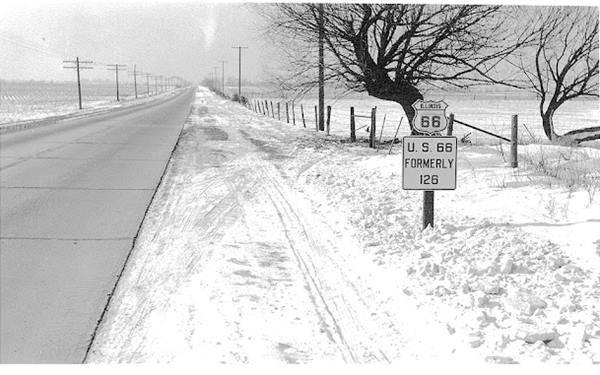
This area was open fields and countryside in the 1940s as you can see in the picture. The factories and warhouses that now line the freeway didn't exist. Farms dotted the fields. After 1958, the superhighway built into Chicago overlaid the original highway roadway. Nothing remains of the few gas stations that stood by Route 66 at that time. The lakes that can be seen north and south of the highway didn't exist in the 1940s, they were dug later, during the 1950s and 60s.
The glaciers left gravel deposits across northern Illinois, and the Material Services Railroad and Chicago Gravel Company, both actively quarried here for gravel. The depleted gravel quarries flooded with rain and snomelt creating many of the lakes in the Plainfield area. Some of them have become Forest Preserves such as Lake Renwick to the Southeast of Plainfield.
Maple View Texaco amd Coffee Shop (gone)
The highway enters Plainfield along W Main St., crossing the Elgin Joliet & Eastern railroad with a grade crossing to your right is the cement grain elevator structure built in 1921 with a capacity of 100,000 bushels.
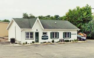
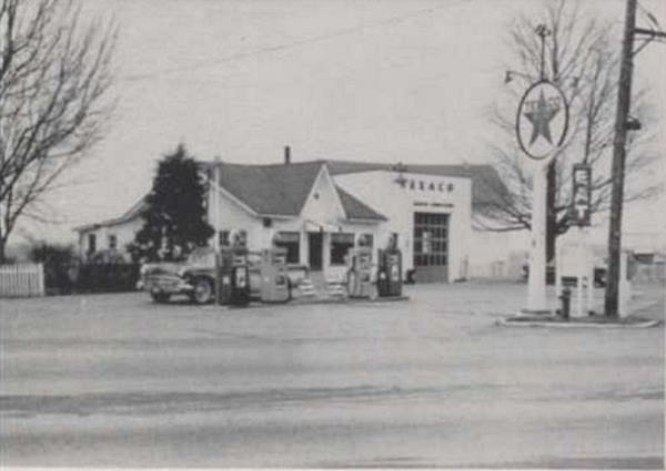
Ahead the highway meets Division Street (IL-59) and it turns south (left) along it. Here on the NW corner (currently Flanders Court) was the now gone Maple View Texaco station. It opened in the 1920s and had a cottage-style building that housed a café ran by Ella Klomhaus. The building was moved in 1963 and has survived until this day, now it is located at 15518 Joliet Rd, Plainfield, and serves as an office for a local business. Below is a view of it in 1958; you can compare it with its current appearance.
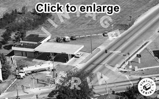
1988 aerial view former Hall's Texaco. Source. Click image to enlarge
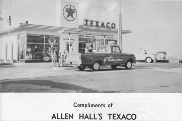
A new building with the typical 1960s Texaco design replaced the former one; it had a pylon extending beyond roof and used to display back-lite Texaco logo and a stepped (two-part) flat roof over office and service area. The station was now owned by Allen Hall, pictured below in the local highschool's 1965 yearbook. Hall also owned another Texaco a few blocks south, on former US 66 and US 30. At one time he'd operated the Historical Standard Oil Gas Station (a Texaco when Hall ran it) in downtown Plainfield.
Eventually it became a Mobile gas station (see the 1988 aerial photo) and was torn down by 2002.
Morel's Mobil (gone)
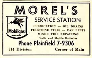
1954 phone directory ad, Morel's Mobil US 66, Plainfield . Source
Turn south along IL-59 (former Route 66) on the SW corner of the crossroads was another gas station where the Walgreens now stands. It was Alvin Morel's Mobil Service Station. He opened it in 1940 on the new Route 66 alignment, moving from his former site on Lockport St. Much later it became Taylor's Mobil. See its 1954 telephone directory advertisement in the image.
Continue westbound along IL-59.
The Lincoln Highway Meets Route 66
Lincoln Highway and US 66 meet in Plainfield. A. Whittall
Two blocks further south is Lockport Avenue, the main east-west throughfare in Plainfield. Here is where Route 66 met the Lincoln Highway. From this point and for the next three blocks, Route 66 and the Lincoln Highway overlap.
The Lincoln Highway
Like the National Old Trails later followed by Route 66 from New Mexico to California or the Ozark Trail along which Route 66 was aligned from NM to MO, the Lincoln Highway was a private initiative. Cars needed decent roads, the dirt trails built for horse-drawn carts that became quagmires when it rained were not suitable for automobiles.
Carl Fisher owner of the Prest-O-Lite Headlight Co. and founder of the Indianapolis Motor Speedway canvassed his fellow automobile industry entrepreneurs and founded the Lincoln Highway Association in 1913. Its objective was to build a decent highway across America from New York to San Francisco; the road was dedicated to Abraham Lincoln.
It became the first paved transcontinental highway and was 3,400 miles-long. It was paved through Plainfield in 1921 and linked Times Square with the Golden Gate.
Road signs: Lincoln Highway Meets Route 66 in Plainfield, Illinois. This marker is south of town, where US 30 and IL-59 meet
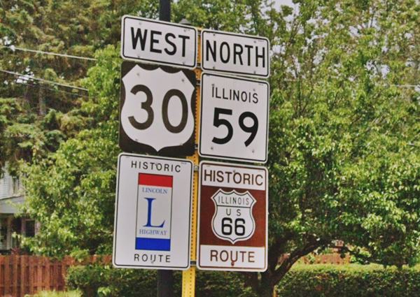
The Illinois portion of the Lincoln Highway was designated as an Illinois State Scenic Byway in 2000 and a National Scenic Byway.
In Plainfield the Lincoln Highway follows: (from east to west): US Route 30, Joliet Road, Illinois Route 59, Lockport Street, former US Route 30, 135th Street and Heggs Road.
Route 66 and Lincoln Highway
Both highways meet twice in Will County. The first, took place in 1926, when a brand new Route 66 was aligned through Joliet, crossing the Lincoln Highway there (read more about Lincoln Highway and Route 66 in Joliet). After 1940 the Joliet roadway was redesignated Alternate 66 and U.S. 66 was realigned through Plainfield, where it met the Lincoln Highway once again and remained so until it was delisted in 1977.
Overlap of both highways
Both U. S. Route 66 and the Lincoln Highway shared a common alignment along three blocks. Plainfield is the only place in the nation where the two, nationally-designated, scenic byways share a common route.
The two longest highways in the world at that time met in Plainfield Illinois.
When the U.S. Highways system was implemented in 1926, Lincoln Highway became, for the most part, U.S. 30 between Pennsylvania and Wyoming, here in Plainfield U.S. 3O still runs across the town.
Plainfield’s Downtown Historic District
Listed in the National Register of Historic Places
At the crossroads with Lockport St., turn right and take a short detour to visit the Historic Downtown District of Plainfield.
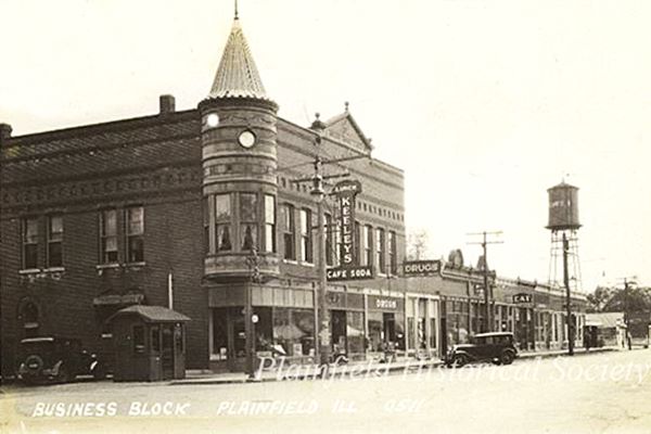
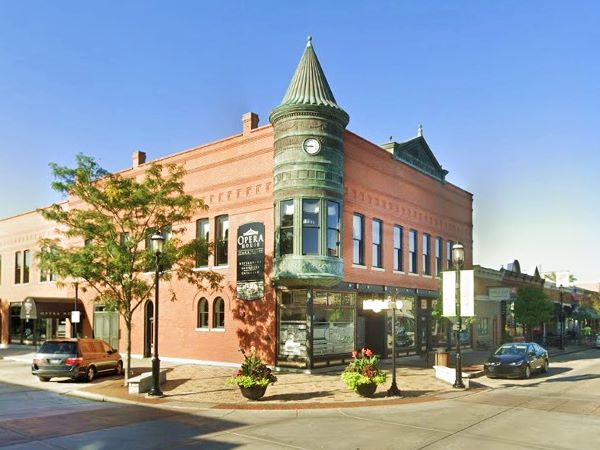
Plainfield's Downtown Historic District runs along Lockport Street (Lincoln Highway) between Route 59 and James Street. It includes 53 properties of differenty styles and building types that span 120 years, from the 1840s to the 1960s, in Plainfield, Will County's oldest community. Below is just one example of the historic district, the "Opera House Block" in a "Then and Now" sequence.
The Opera House Block on 502 W. Lockport Street was built in 1898 in the Queen Ann Style and the copper roofed turret is its distinctive feature. It replaced the original Opera House that burned down in the 1898 fire.
It became a live and movie theater in 1915 (the Alamo Theater) and later it was a dance hall (The Blue Goose). It has been restored and is still standing.
Opera House Block, "Turret" vintage photo in Plainfield, Illinois
Opera House Block, "Turret" nowadays in Plainfield, Illinois
Trivia: Home of the First Ice Cream Sundae
A Plainfield druggist whose German surname was "Sonntag" (Sunday) topped ice cream with syrup and nammed it after himself. The "sonntag" soon became the "sundae." 1
Historical Standard Oil Gas Station
Listed in the National Register of Historic Places
On the next block, at 600 W. Lockport Roadto your left, is a Historical Gas Station. It was designed in the "House with Canopy" style, a white stucco building with a red metal tile roof. It was built in 1928 on a corner location on the Lincoln Highway, key site in those days on the new U.S. 30.
It started in 1932 as a Standard Oil gasoline station. Shortly after, it became "Overman's Certified Texaco Station" and from 1956-1962 it was Allen Hall's Texaco. Below is a picture of it when it was Hall's Texaco in the 1958 local highschool's yearbook.
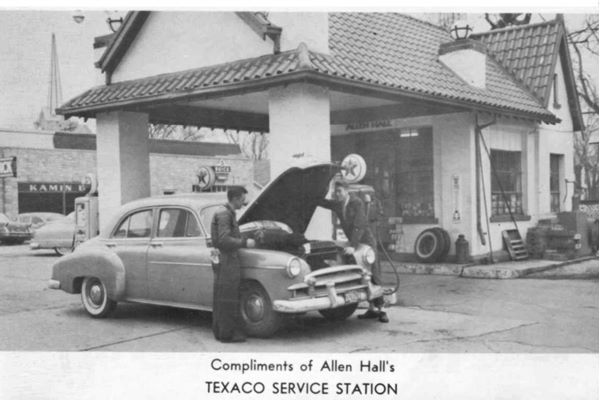
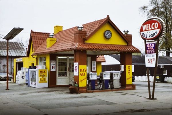
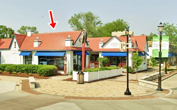
By 1966 it had become Bill Price's Welco Gas Port, as shown in the photograph below. It closed in 1983. It was renovated and enlarged by the Andreasen's as "The Courtyard" retail complex built with a similar design.
Historical Standard Oil Gas Station in 1977 in Plainfield, Illinois
Below is a more recent view, now as a repurposed building within a larger complex. The red arrow marks the corner builiding, formerly the gas station.
The Plainfield Inn
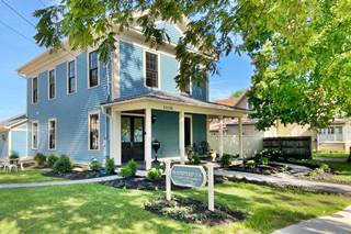
Head west along W. Lockport Rd. for one block. Turn left along S. Fox River St., the second house from the corner, to your right, is a historic building that has been restored and repurposed as an inn (The Plainfield Inn).
At 15106 South Fox River St. Plainfield. The building was originally a schoolhouse built in 1851. It became a home in 1882, and over the last 135 years has been home to three families: The Goodson⁄ Herrington family line, the French family and now the Myers family.
It is a beautiful example of 19th century Greek Revival architecture with a low pitched roof and pediments that remind us of the roof of a Greek temple (like the Parthenon).
Turn around and return to Route 66 and Lockport Rd., turn right to continue westbound.
South Side of Plainfield
Reichert's Standard Station & Mom's Coffee Shop (gone)
Located on the southeastern corner of the crossroads was a Standard Oil gas station built here after 1946; it can be seen in this aerial photo taken in 1952. It opened in 1948 and was ran by the Reichert brothers Paul, and Sam. The adjacent Coffee Shop was ran by the Chobars, Beatrice "Bea" and James "Jim". It was torn down in the late 1980s, a bank stands on the property.
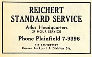
1954 phone directory ad, Reichert Standard Service, US 66, Plainfield.
Source
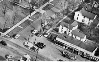
1950s air view of Reichert Standard Service, US 66, Plainfield. Source.
Click image to enlarge it.
The image above (Click on it to enlarge it) shows the intersection of Route 66 (running left to right) and Lockport Rd (running top to bottom), the Standard Station can be seen on the lower right side of the image.
"Sam" Reichert Sr. - Route 66 Hall of Fame Inductee
Samuel ("Sam") L. Reichert, Sr. (1919-2004) served in the Army during WWII and was awarded a Purple Heart. He worked as a Greyhound Lines bus driver on Route 66, later he worked at Russell's Standard Station, and after 1953 replaced his brother Paul at the Lockport Rd. station. He was inducted into the Illinois Route 66 Hall of Fame in 2012.
Sebby's Phillips 66
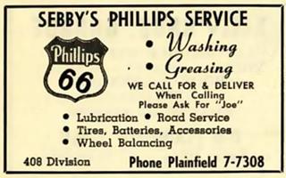
1954 phone directory ad, Sebby’s Phillips66, US 66, Plainfield.
Source
Drive west along Route 66 and on the SW corner with Ottawa St., to your right is a gas station from 1940. Robert "Bob" Worst opened it here in June 1940, on the then brand new Route 66 alignment across Plainfield in those days it was numbered as 408 Division ST. When he went to serve in the Army during WW II, Roy Sebby took over the service station. Below is how it looked in 1958, whith its attendants offering "Deluxe service".

Sebby moves to a new site
In 1959, after Route 66 was realigned along what now is I-55 and traffic dropped along the Old '66, Sebby sold this station and opened a new Phillips 66 on U.S. 30, known as Lincolnway, that gas station has survived; it was built in the Rock Frame style typical of that period, with canting plate glass windows. Below is a current view and a 1965 aerial picture.
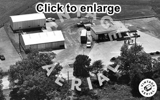
1965 aerial photo, Sebby’s Phillips 66 on US 30, Plainfield.
Source. Click to enlarge
Finally a Shell
When Sebby sold the Phillips 66 station it became a Shell, owned by James E. Biggins, pictured below.
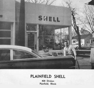
1966 Plainfield Shell station. Source. Click to enlarge
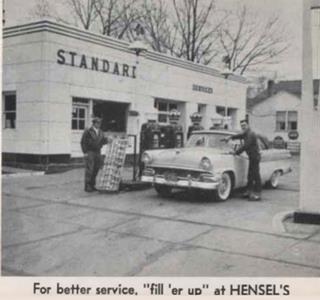
1958 Hensel's Standard Station. Source. Click to enlarge
Russell's Standard Station, later Hensel's (gone)
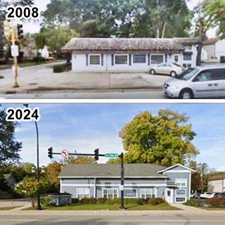
On the same block, at its NW corner with Commercial St. was Walt Russell's Standard Service Station, at 400 Division St. Now the Plainfield Dental Clinic stands o the property. It figures as Russell's station in the 1954 phone directory.2 Two years later it had become Hensel's Standard Station, pictured above.
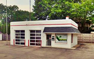
The other picture shows it before it was repurposed, in 2008, and nowadays.
The local highschool yearbook mentions Barry and Al's Standard Service in 1965 and again Al's Standard Service in 1971 located at "Routes 59 and 30." Surely referring to this one as the only other service station at the crossroads was Hall's Texaco.
Hall's Second Texaco
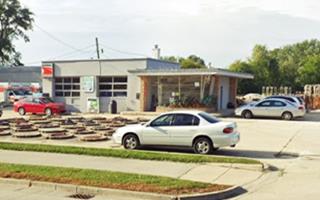
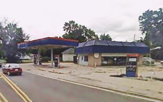
Allen Hall had his second gas station on the fork where U.S. 66 headed south along Division Street and U.S. 30 with the Lincoln Highway went towards the southeast heading to Joliet. This one was locaed at "Routes 30 and 66" offering "Cab Service, Snow Plowing, Road Service and Towing". Below is a picture of it taken in 1965. The other is a view from 2008 before it was torn down.
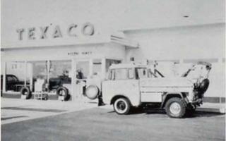
1965 Hall's 2nd Texaco on US 30 & 66, Plainfield.
Source. Click to enlarge
Ferd's Motor Sales Garage
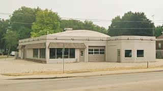
Mentioned by Rittenhouse in 1946 (actually, it was the first named business in his guide), the dealership's building is still standing one block from Hall's, to your left on the SE corner of US 30 with South Dillman St. It is a large brick building, in good shape, single story, with garage service bays and large windows for displaying vehicles; a semi domed roof crowns the building. Below is a vintage ad as a Chevrolet dealership offering super service at 221 Joiet Rd (U.S. 30), and its current appearance.
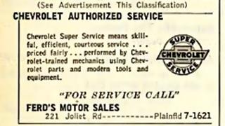
1954 phone directory ad, Ferd's on US 30, Plainfield.
Source
Your city tour in Plainfield ends here. There were some more sights along Route 66 south of the town, and we mention them below to record them as part of the highway's history. They are on the leg linking Plainfield with Braidwood along the 1940-58 Route 66 alignment.
Troy (now Shorewood)
Facts, Information and trivia
Elevation: Elevation 620 ft (190 m). Population 18,186 (2020).
Time zone: Central (CST): UTC minus 6 hours. Summer (DST) CDT (UTC-5).
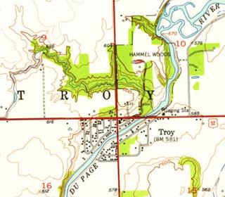
The map shows Route 66 running from top to bottom (north to south) and US 52 running right to left (east to west).
Rittenhouse mentions in his 1946 guidebook that six miles south of Plainfield was the "Junction with US 52. Gas; cafes." This crossroads was a small community known as Troy.
Troy township is part of Will County and its first settler, Horace Haff who reached the area in 1830 proposed calling it West Troy after his hometown of Troy in New York state which in turn is named after the famous city of Troy named in Homer's classic Greek poem, the Iliad.
It was a fishing village on the DuPage River, later it became a resort chosen by people from neighboring Joliet, and also from Chicago to vacation.
When the town incorporated in 1957, it couldn't adopt the name Troy because there was already a town with that name in Madison County, so the locals selected Shorewood to name the village.
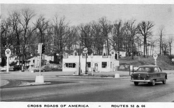
On the northwestern corner of the crossroads there was a Texaco station, pictured above. Now there is a mall (Anderson's Plaza) on the site. Opposite, on the northeast corner there was a Standard Service station (pictured below), now a Burger King.
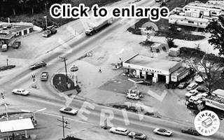
1971 aerial view NE corner US 66 and 52 in Troy. Source. Click image to enlarge
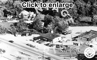
1971 aerial view SE corner US 66 and 52 in Troy. Source. Click image to enlarge
On the Southeastern corner there was a bar-cafe, that is still standing, now operating under the name of The Crowd Around Me. There was a gas station on the corner, that is gone and some shops south of it, also gone.
Continue your Road Trip
This is the end of your Route 66 Road Trip through Plainfield, head westwards to visit Braidwood on the 1940-77 Route 66 alignment, or take US 52 into Joliet and head west to drive the original US 66 alignment (1926-40), and 1940-67 Alt 66. Both roads meet in Braidwood anyway.

Sponsored Content
>> Book your Hotel in Chicago

Credits
Banner image: Hackberry General Store, Hackberry, Arizona by Perla Eichenblat
Jack DeVere Rittenhouse, (1946). A Guide Book to Highway 66.


