Route 66 in Romeoville IL
Index to this page
About Romeoville IL
Facts, Information and trivia
Elevation: Elevation 617 ft (188 m). Population 40,177 (2022).
Time zone: Central (CST): UTC minus 6 hours. Summer (DST) CDT (UTC-5).
Romeoville is a village in Will County, Illinois. It is located on Route 66 - ALT US 66.
History of Romeoville
Illinois' first inhabitants peopled the area about 11,000 years ago at the end of the last Ice Age. During more recent times, the Potawatome people lived here.
Louis Jolliet and the Jesuit Missionary Father Jacques Marquette explored the region in 1673, paddling up the Des Plaines River which runs just east of Romeoville, and claimed the region for France ("New France").
Des Plaines River
The river is 133 miles (214 km) long and has a discharge flow of 535 cubic feet per second (15 m3⁄s). It runs from southern Wisconsin to western Chicago and then west and south, meeting the Kankakee River to form the Illinois River, which in turn flows into the Mississippi River.
It was used as a trade route by the locan Indians, the French used it too, and named it as La Rivière des Plaines (River of the Plane Tree) after the trees along it. They used the word "Plaine" to name the American sycamore and the red maple both of which resembled the European plane tree.
The Des Plaines linked with the Chicago River across the Chicago Portage, a link that had strategic importance and led to the creation of Fort Dearborn in 1803, where Chicago is now located.
The first settlers in the region arrived shortly after the state of Illinois joined the Union in 1818. But a real influx of pioneers began in the 1830s.
In the 1830s the Indian Removal Act was passed and the Native Americans were forcibly removed west of the Mississippi River. Will County was established in 1836.
Trivia
There is a similar sounding Romeroville, on Route 66 in New Mexico. Romero is a Spanish surname. Romeo comes from Latin.
Romeo was platted in 1835 and work began on the Illinois and Mississippi Canal in 1836 that was built between 1836 and 1848, further south Lockport and Juliet (now Jolliet) were laid out in 1837.
The village began as a small farming community but later became a quarry that provided material for roads and buildings and was shipped out using the the Chicago Rock Island and Pacific Railroad. The State Capitol in Springfield is built with Romeoville limestone. The town was known as "Stone City".
Later, for sanitation purposes the Chicago Drainage Canal was dug (1892 to 1900). It ran parallel mostly to the old I&M canal, but its purpose was not only navigation, it was built to reverse the flow of the Chicago River inland so that the sewage of Chicago didn't mix with its drinking water supply, Lake Michigan. It eliminated the constant cholera outbreaks.
The village incorporated in 1895 and its name changed from Romeo to Romeoville.
The name: Romeoville
Italian form of the Late Latin name Romaeus meaning "a pilgrim to Rome". The name is well known as the lover of Juliet in William Shakespeare's tragedy 'Romeo and Juliet' (1596).
Perhaps it was named to complement the town of Juliet -now Joliet.
At the turn of the last century, Isle La Cache and Romeo Beach were favored as countryside resorts, linked to Chicago by a streetcar line. Route 66 was aligned through the town in 1928. In the early 1930s, the drainage canal was deepened becoming the Chicago Sanitary and Ship Canal.
The completion of I-55 in the 1950s changed the countryside from a farming area to a suburban one, with the local residents commuting into Chicago daily, to work there.

Accommodation near Romeoville
> > Book your hotel in Romeoville
Find More Accommodation near Romeoville along Route 66
Below you will find a list of some of the towns along Route 66 east and west of this town; click on any of the links to find your accommodation in these towns (shown from east to west):
Along Route 66 in IL
- Hotels in Illinois
- Route 66 Starting point ▸ Chicago
- Lockport
- Willowbrook
- Bolingbrook
- Plainfield
- Romeoville
- Joliet
- Wilmington
- Dwight
- Pontiac
- Chenoa
- Normal
- Bloomington
- Atlanta
- Lincoln
- Springfield
- Raymond
- Litchfield
- Staunton
- Williamson
- Hamel
- Edwardsville
- Collinsville
- Troy
- Glen Carbon
- Pontoon Beach
- Granite City
- East St. Louis
West in Missouri
- Hotels in Missouri
- Florissant MO
- Bridgeton MO
- St. Louis MO
- Kirkwood MO
>> See the RV campgrounds in Chicago or Joliet
The Weather in Romeoville
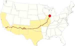
Map showing the location of Romeoville, Illinois on U.S. 66
Romeoville's climate is humid and continental; with very well defined seasons: Spring is cool and wet; summer is hot and frequently humid. Winter is cold and has on average 28 inches (71 cm) of snow, while autumn is very mild.
Temperatures: Average high in Jan (winter) 31°F (-0.3°C) and the average low is 17°F (-8.6°C). Average high in Jul (summer) 84°F (29°C), with an average low of 64°F (17.7°C).
Rain averages 36.82 inch (936 mm) per year and it is heighest - 3 to 4.3 inch monthly (78 and 110 mm) from Apr. The rest of the year has an average of 1.7 in. (28 mm) per month.
Snow: In Romeoville you can expect snow from October to April, however usually the first snow falls in Nov. and the last happens in April (usually one quarter inch - 8 mm).
Tornado risk
The area that surrounds Romeoville gets some 5 tornado strikes every year.
Tornado Risk: read more about Tornado Risk on US 66.
The Maps of Route 66 in Romeoville IL
>> Our Custom map shows the alignments of U.S. 66 in Romeoville.
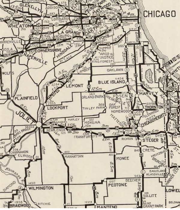
The map above was published in 1924, two years before Route 66 was created. It displays the "Auto Trails" or roads that could be driven by cars. The ones close to Rockport are marked with numbers: as "34" for the "Lincoln Highway" through Joliet and Plainfield, or "13" for the "Mississippi Valley Highway" from Lyons, through Lockport. The number "4" inside a white circle is State Highway 4. Romeoville does not appear in this map as the main road through it from Lyons to Joliet was unpaved. It can be seen on the left side of the Des Plaines River.
State Highway 4
Illinois funded its original state highway network by floating a bond in 1918. Among the roads built was SBI 4 (State Bond Issue Route 4) that was aligned along what had been the "Pontiac Trail" that ran from Chicago to St. Louis. Originally it was aligned to the northeast of Joliet, by the Collins Street State Prison, to Lockport, and then curving along the Des Plaines River eastwards into Lemont, Argos and Summit, where it crossed the river and canal to enter Lyons.
Route 66's first alignment in 1926
Route 4 was paved completely by 1923 so it was the logic choice for the alignment of Route 66. Both highways overlapped until the signs of the old state higway were finally replaced by the U.S. 66 shields in 1927. It ran through Lockport.

1928 Illinois State roadmap (see State Hwy 4A). Source
Click map to enlarge
Route 4A and the new Route 66 alignment (1928?)
But soon the new roadway that ran along the north and western side of the Des Plaines river through Romeoville, with a straighter course across open countryside with farms and fields (the current town of Countryside on this alignment got its name for this reason). The new alignment avoided the urban crossings of Summit, Justice, Argo, Lemont and Lockport; it also eliminated many sharp curves and turns.
The new alignment was re-designated as both US 66 and Route 4. The old alignment was designated as Route 4A. You can see it in the map (click to enlarge). Near Romeoville, it ran along what is now IL-53 from I-55's exit 267 and Joliet Rd (green line in our custom map). But shortly after it was shortened by aligning it along Joliet Rd. to Welco Corners.

1927 Chicagoland map. Source
Click map to enlarge
The 1927 map of Chicagoland shows both Route 4 and 4A the thumbnail image (click to enlarge) shows them from Lyons to Joliet. Notice the many curves and turns along 4A vs. Route 4. Both start in Cicero and meet in Joliet after splitting in Lyons.
Maps of the different alignments
The color keys to the alignments in Romeoville, and a brief description of each one is given below.
The bordeaux line in our custom map is the one described further up, along the south and eastern sides of the Des Plaines River along the original IL-4 highway. Used from 1926 to 1928.
In 1928 it was realigned along the north and western side of the river (violet line from Lyons to Welco Corners, and pale blue through Romeoville to Joliet). It carried U.S. 66 from 1928 to 1940.
Realignment of Route 66 through Plainfield, this took place in 1940 (red line from Welco Corners to Plainfield and yellow line south of it). The older alignment became ALT 66.
The ALT 66 alignment remained in use until February 1967 when it was replaced by Illinois State Highway 53 from Welco Corners to Gardner.
In 1958 US 66 was moved east west to a brand new freeway that now bypassed all the towns including Plainfield, Braidwood and Gardner. US 66 and I-55 shared the freeway until 1977; see the violet lines in our custom map from Gardner and east of Plainfield.
The old Route 66 is a Historic highway and has also been designated as a National Scenic Byway and an All-American Road in the state of Illinois.
The Route 66 alignments near Romeoville
Description and interactive maps of US 66.
- Pontiac to Springfield (next)
- Chicago to Pontiac (Romeoville's)

Romeoville's Route 66 Landmarks and Attractions
What to see in Romeoville
US 66 in Romeoville: historic context
In 1946 Jack DeVere Rittenhouse published his "Guide Book to Highway 66" in which he describes the whole road from Chicago to Los Angeles. He does not mention Romeoville because he drove the "Main US 66" through Plainfield.
The WPA's guide to the state of Illinois published in 1939 mentions it in its Tour 22 as follows:
... the village of ROMEOVILLE (L), 31.3 m. (590 alt., 133 pop.), which developed along the Illinois and Michigan Canal. The industrial plant visible from the waterway is a Globe Oil Refinery. Petroleum and petroleum products are among the principal goods transported on the waterway ; they are second only to coal in tonnage. A Butterfly Dam occupies the center of the channel at 34 m. Its function is to serve as an emergency dam should the one at Lockport fail to function. Inasmuch as it remains open at all other times, it is not equipped with locks. WPA (1939)
Route 66 Road Trip Leg in Romeoville
Begin your tour driving west from Willowbrook and you will reach Welco Corners.
Welco Corners
Rittenhouse describes this spot known as Welco Corners: "About 25 miles from City Hall, you will reach a fork in the road, where main US 66 goes ahead to Plainfield and alternate US 66 forks left to Joliet." He adds that you can take either course because they meet further down, but he only describes the main and not the alternate routes in his guide, so he continues to Plainfield.
Welco Corners was the fork on Joliet Road, and there was a truck stop here, Welco Truck Stop between both Main and Alternate alignments. The construction of the current exchange at Exit 269 between I-55 and IL-53 has mostly razed the site.
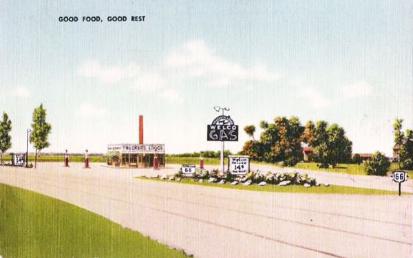
The place got its name from Wells Petroleum Co., owned by Charles F. Reid, a Chicago based oil company. . Their matchcove (pictured) reads: "Good Food. Welco Truckers Lodge No. 1 U.S. Highways 66 & 6A 10 Miles E. of Plainfield. 12 Miles N.E. of Joliet Illinois." There was a "Lodge No. 2 U.S. Route 6 Walkerton Indiana." Their road maps and mathcovers proclaimed that "Welco Means the Best in Gasoline. Oils. Food. Service. Bunk Rooms. Showers." The company owned the Welco Penn motor oil brand too.
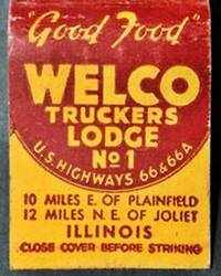
Welco Truckers Lodge
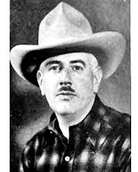
Charles Reid, 1939. Source
"Montana Charlie" Reid owned the truck stop, a restaurant in Villa Park (Montana Charlie's Chuck Wagon) and a chain of gas stations. An entrepreneur, he also opened the Kiddie Park and Golf Circus in 1939 in Chicago. We believ that we was the same Charles F. Reid who was Welco's president in the 1930s.
The Internet promotes an urban myth that says that in the early 1900s he rode on horseback from his native Chicago to Montana, worked as a cowboy on a ranch, and later was employed in traveling carnivals, the River Queen, and rode in the Browning Circus. The urban myth says that he ended up as the chauffeur of an oil tycoon who deeded him his wealth when he died. Montana Charlie passed in the 1980s.1, 2, 3, 4
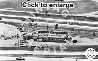
1971 aerial view Welco Corners. Source. Click image to enlarge
Welco was decorated with two life-sized steers on its flat rooftop, it had a restaurant the "Here you Save!" sign and "Montana Charlie's Snack Shop" signs over the entrance. The steers can be seen on the left side of the building in the 1971 aerial view.
Now a Truck repair and lubrication business stands on the property (street view).
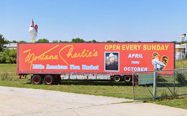
Montana Charlie's Flea Market
Down the road, at 255 South Joliet Rd. is the flea market that opened around 1965 and was named for Montana Charlie. When it is open (April through October), a giant rooster is mounted on top of the red semi by the entrance (Montana Charlie's picture can be seen on the side of the semi).
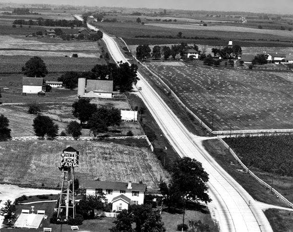
The White Fence Farm
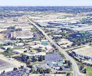
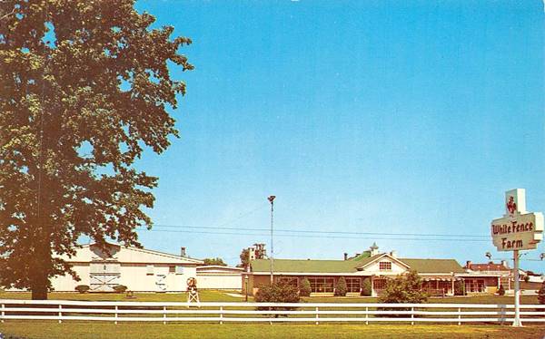
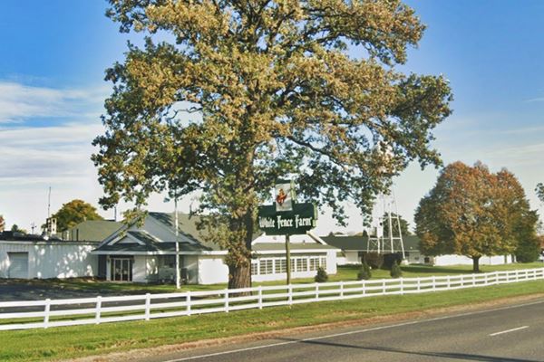
As you drive westwards it is hard to realize thhat this area was open countryside until the late 1950s. It was then that the urban sprawl of Greater Chicago reached the area. There are warehouseds and factories between I-55 and the Des Plaines River, and a vast expanse of suburban homes beyond. Almost 1.5 miles west of the flea market, to your right, at 1376 Joliet Rd. is a classic restaurant from the 1920s. The view below looks eastwards and shows the rural setting that the highway ran through. The other image is a current one, showing the same view but totally built up.
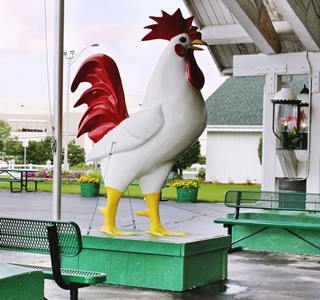
Giant chicken at White Fence Farm. Source. Click image for St. view
Built by Stuyvesant "Jack" Peabody on a 12 acre plot of a larger 450-acre farm (Lemont horse farm in the early 1920s). It struck gold when Route 4 was aligned by it
Not far from the big city it offered Chicagoans a countryside setting for dining. Peabody died in 1946 it was leased out and eventually bought by the Hasterts (1954) and Robert and Doris' son, Robert Jr. still owns the place. The company has branches in different towns, and the menu still offers "The World's Greatest Fried Chicken" and the restaurant can sit 1,000 guests.
There is a Route 66 wayside exhibit on the premises telling its story. Don't miss the giant chicken at the main entrance (pictured).
The White Fence Farm vintage postcard in Romeoville, Illinois
The old neon sign is still there, and more colorful than in the past.
The vanished landmarks along Route 66 - All Gone
Urban growth has eliminated several original Route 66 buildings along the following miles. Some were listed in the Illinois DOT's Route 66 in Illinois 2012 ⁄ 13 survey. Below we describe these and other classic sites with some pictures of them while they were still standing.
Texaco Gas Station
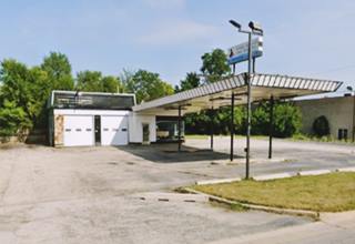
At N Independence Blvd 639. It was originally a Texaco gas station, later a used car dealership (Route 66 Auto Mart). Tecaco called it the "Matawan" station as it was first introduced in Matawan, New Jersey. It had stone veneer and a roof with Ranch Style influences, a semi detached canopy with angled sides. Torn down between 2021 and 2022.
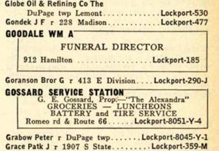
Gossard Service Station 1940 phone book entry. Source
Gossard Service Station
The 1940 Lockport phone directory mentions "Gossard Service Station. G. E. Gossard, Prop - "The Alexandra" Groceries - Luncheons Battery and Tire Service Romeo rd & Route 66." In a 1939 aerial photo of the crossroads, the gas station can be seen on the SE corner, facing Route 66, gable roofed. It survived until the late 1970s. The Cafe Romeo stands on the site.
Bel-Air Drive-In
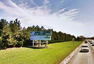
Just ahead, to your left, where the Romeroville Storage Sense is now located, was the Bel-Air Drive-In. It opened in 1949 and closed in the late 1980s. It could fit 1,000 cars. The old marquee stood until 2012 advertising the storage space. See this aerial photo of the drive-in taken in 1961.
Two Garages
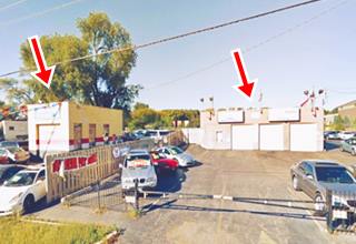
The IDOT survey mentions two buildings to your right, on the NE corner with Airport Rd. They ended their days as used auto dealers. The first at 15050 S Independence Blvd, had three service bays and a stone facade. It was described as "ca. 1930s 40s gas⁄service... an old vehicular service facility."
The other building to the left (south) at 15056 S Independence Blvd. was a smaller, narrow, block shaped structure with one service bay; it was a "ca. 1950s Auto Service ... "Auto Planet" utilizes an old, concrete block service garage on RT." Both pictured above in 2013 before they were torn down.
Historic Fitzpatrick House
Listed in the National Register of Historic Places
Drive south for 0.8 miles along US 66 you will see the site to your left, on the eastern side of the highway (See location map). There is parking space at the site.
This was the homestead built in Greek Revival style by Patrick Fitzpatrick with local limestone in the 1840s. He built it on his 700-acre farm next to the Old Indian Trace (trail) and used it to ship his crops out to neighboring Lockport and the Illinois & Michigan Canal.
There is a Route 66 wayside exhibit at the site.
Historic Fitzpatrick House in Romeoville, Illinois
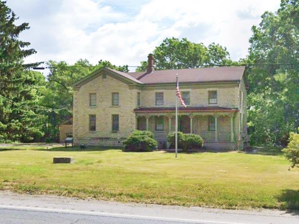
The Fitzpatrick family donated land to the Archdiocese of Chicago, which founded Lewis University in 1932.
Continue your Road Trip
This is the end of your Route 66 Road Trip through Romeoville, head westwards to visit Lockport, to continue your journey.

Sponsored Content
>> Book your Hotel in Chicago

Credits
Banner image: Hackberry General Store, Hackberry, Arizona by Perla Eichenblat
Jack DeVere Rittenhouse, (1946). A Guide Book to Highway 66.


