Route 66 in Elwood IL
Index to this page
About Route 66 in Elwood IL
Information, facts and trivia
Elevation: Elevation 648 ft (198 m). Population 2,170 (2024).
Time zone: Central (CST): UTC minus 6 hours. Summer (DST) CDT (UTC-5).
Elwood is a village in Will County located on Route 66 in NE Illinois.
History of Elwood
The area has been inhabited for at least 11,000 years. The French explored the ara in the mid 1600s, and in 1673, Louis Jolliet and the Jesuit Missionary Father Jacques Marquette paddled up the Des Plaines River (just west of Elwood) and reached Lake Michigan.
After France was defeated by the English during the "Seven Year War" it was incorporated to their American Colonies and as such the territory became a part of the US after its independence. It became the state of Illinois in 1818.
The place had been known as Reed's Wood, after the first settler, Charles Reed and his family. Will County was created in 1836 and named for Dr. Conrad Will, a member of the first Illinois Constitutional Convention and member of the Illinois Legislature.
The post office opened here in 1846 and was named Reed's Wood. When the Chicago & Alton Railroad passed by the area in 1854, a railway depot was built and a village was platted.
The village was renamed Elwood in 1855, and it incorporated as a village in 1869.
It was a farming community until 1940 when the Arsenal was built here in preparation for the inevitable War with Germany. The site was selected alongside Route 66 which had been aligned through Elwood in 1926. It became a four lane highway northwards into Joliet to allow the heavy truck traffic along it, and renamed ALT 66 because a new roadway was built to the west of Elwood, between Plainfield and Gardner, to carry the increased wartime traffic. The new roadway became the Main US 66.
The name: Elwood
It was named for N.C. Elwood, mayor of Joliet in the 1850s. The surname is a "locational" one, identifying people who lived in Ellwood, Gloucestershire (from "the elder wood" in Old English).

Elwood: Hotels and Motels nearby
Accommodation close to Elwood.
> > Book your hotel in neighboring Joliet
Find More Accommodation near Elwood along Route 66
Below you will find a list of some of the towns along Route 66 east and west of this town; click on any of the links to find your accommodation in these towns (shown from east to west):
Along Route 66 in IL
- Hotels in Illinois
- Route 66 Starting point ▸ Chicago
- Lockport
- Willowbrook
- Bolingbrook
- Plainfield
- Romeoville
- Joliet
- Wilmington
- Dwight
- Pontiac
- Chenoa
- Normal
- Bloomington
- Atlanta
- Lincoln
- Springfield
- Raymond
- Litchfield
- Staunton
- Williamson
- Hamel
- Edwardsville
- Collinsville
- Troy
- Glen Carbon
- Pontoon Beach
- Granite City
- East St. Louis
West in Missouri
- Hotels in Missouri
- Florissant MO
- Bridgeton MO
- St. Louis MO
- Kirkwood MO
>> See the RV campground nearby, in Braidwood and Joliet
The Weather in Elwood
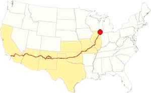
Map showing the location of Elwood, Illinois on U.S. 66
The climate of Elwood is a humid continental one with all four seasons distinctly represented; summers are hot and humid, spring is wet and cool, fall is mild and pleasant while winters are cold.
Temperatures: The average winter (January) high is 31°F (-0.3°C); and the average low is 17°F (-8.6°C). The summer average high (July) is 84°F (29°C) and the average low is 64°F (17.7°C).
Rainfall ranges from 3 to 4.3 (78 and 110 mm) inches monthly from April to November, and falls to a drier 1.7 in. (28 mm) the rest of the year. On average, the town gets 36.82 inches of rain each year (936 mm).
Snowfall: on average, 28 inches (71 cm) of snow falls each year in Elwood. The first snow falls in Nov. and the last (less than 1⁄4 inch or 8 mm) falls in April. There is usually no snow between May and September.
Tornado risk
A tornado touched down 3 miles north of Elwood on May 8, 1988, it damaged a few homes and uprooted some large trees but nobody was hurt.
The area that surrounds Elwood gets some 4 tornado strikes every year.
Tornado Risk: read more about Tornado Risk on US 66.
Map of Route 66 in Elwood, IL
>> Our Custom map shows the alignments of U.S. 66 in Elwood.
The map below was published in 1924, two years before Route 66 was created. It displays the "Auto Trails" or roads that were suitable for cars. The ones near Elwood are marked with numbers: as "34" for the "Lincoln Highway" through Joliet and Plainfield, or "13" for the "Mississippi Valley Highway" from Lyons, to Joliet and west across Elwood. The number "4" inside a white circle is State Highway 4.
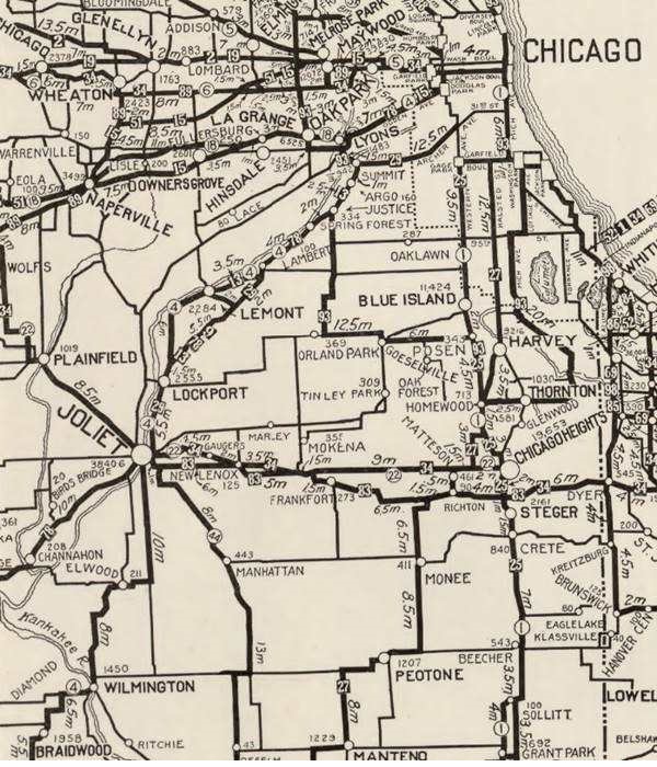

1928 Illinois State roadmap (see State Hwy 4A). Source
Click map to enlarge
To create better roads, the state of Illinois issued a bond in 1918. One of the highways built with it was known as SBI 4 (State Bond Issue #4). It linked Chicago with St. Louis and passed through Elwood, Joliet and then northeast through Lockport and Lemont, Justice and Summit into Lyons.
It was paved completely by 1923 but in 1926 it was realigned along a new road that was built north of Joliet through Romeoville which became Route 4, (the former alignment became State Hwy. 4A).
That same year, Route 66 was created and aligned along Route 4's roadbed.
Route 66
US 66 1926 to 1939
The first alignment across Elwood is shown with blue lines in our custom map.
ALT US 66 1940 to 1967
As the truck traffic grew during the war the road between Elwood and Joliet was widened to four lanes, red line and designated as ALT US 66.
A new roadway was built with a straighter alignment west of Elwood and Joliet, through Plainfield and it was designated as US 66; see the yellow line in our custom map.
This ALT 66 alignment ran south from Romeoville through Joliet, Elwood, Wilmington, Braidwood, Godley and Braceville, meeting the Main 66 at Gardner. The Alternate 66 alignment was eliminated in February 1967 and replaced by Illinois State Highway 53 from Welco Corners to Gardner.1
US 66 final years: 1958 - 1977
In 1958 US 66 was moved east west to a brand new freeway that now bypassed all the towns including Plainfield, Braidwood and Gardner. US 66 and I-55 shared the freeway until 1977; see the violet lines in our custom map west of the Kankakee River (near Braidwood), and east of Plainfield.
Alternate US 66
In 1959 the American Association of State Highway and Transportation Officials (AASHTO) came up with the "Alternate" designation.
It was to be used to designate a highway that branches off from the main one, passing through certain cities and then links up with the main route again.
If the Main and alternative routes followed a similar course, the better built or shorter highway would be the one marked as "Main", while the other would become the "Alternate" one.
There are only six places along Route 66 where an Alternate 66 alignment existed: From East to West they were this one close on Route 66 into Chicago, Carthage MO, the one in Joplin MO, Oklahoma City, Alt 66 in San Bernardino, California, and the one leading into Los Angeles CA.
Route 66 is a Historic highway and has also been designated as a National Scenic Byway and an All-American Road in the state of Illinois.
The Route 66 alignments near Elwood
Description and interactive maps of US 66.
- Pontiac to Springfield (next)
- Chicago to Pontiac (Elwood's)

Elwood's Route 66 Landmarks and Attractions
What to see in Elwood
US 66 in Elwood: historic context
In 1946 Jack DeVere Rittenhouse does not mention it in his 1946 "Guide Book to Highway 66" because he drove down the Main US 66 built after 1940, he does mention the other "ALT" alignment through Joliet. He also says, after crossing the Des Plaines River: "...for the next four miles you pass the site of the Kankakee Plant of the Joliet Arsenal, active during World War II..."
In its Guide to Illinois published in 1939, the WAP tells us that "Elwood... serves as a countryside that has witnessed a notable experiment in farm rehabilitation..." describing how Arthur States manger of the Wharton estate improved farming techniques in 1924 which allowed 10 out of 12 tenants to buy their farms with their improved incomes.
Your Road Trip leg across Elwood
Drive westwards from Joliet along what now is IL-53, and at one time was US 66. At W Manhattan Rd. the original 1926-39 roadway splits from the later (1940-77) four-lane alignment. Take it, it has a winding course through farmland towards Elwood. It had four right-angle turns and two grade crossings across the railroad (blue line in our map).
1926 -30 alignment into Elwood, Illinois
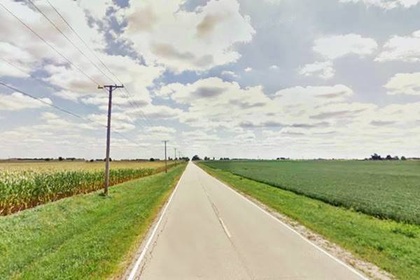
Alternate Route 66 Wilmington to Joliet
Listed in the National Register of Historic Places
The 15.9 mile road segment between Joliet and Wilmington four-lane alignment is a historic site. The original narrow alignment was widened to a 24-foot wide roadbed that was 10-inches thick. A second set of lanes was added north and south of Elwood, and the winding alignment from W Manhattan Rd. to Elwood was bypassed by a brand new 4-lane roadway.
In 1941 it carried on average 8,000 vehicles per day between Elwood and Joliet, and 5,000 westwards towards Wilmington.
The original roadway reaches Elwood but is currently cut by the four-lane highway so the modern alignment of W Mississippi Rd. curves north to pass under the divided highway and then curves south to turn into the town along W Mississippi St.
Route 66 crossroads old an new alignments
Remains of Standard Station
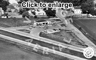
1965 aerial view Elwood's Standard Station. Source. Click to enlarge
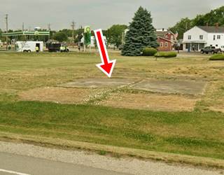
On the original crossroads of Route 66's 1926-39 alignment and the four lane highway there was a Standard Oil gas station. On the SW corner. Later for safety reasons the intersection was realigned to avoid the unsafe crossroads at 45° that caused visibility problems. The aerial picture taken in 1965 looks towards the SW at the corner, showing the icebox shaped Standard station, and its concrete drives linking it with the 4-lane highway and Mississippi St. The current BP satation didn't exist at that time. The concrete driveway of the old gas station can still be seen in the grass (second image, red arrow).
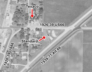
1961 aerial view of Elwood. Source. Click to enlarge
Texaco Station
The same 1965 image shows a gas station just down the street in a gable roofed building next to the Post Office building. It has some pumps lined up facing Mississippi St. (upper right side of the picture), in the 1971 aerial view of that same spot, we see it has Texaco signage. The building is still standing, but isn't a gas station.
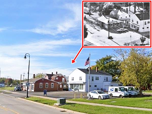
Route 66 Wayside Exhibit on the Curve
Drive one block after passing the BP station and to your left, on the SE corner of Douglas St. and E Mississippi Ave. there are several markers ⁄ monuments commemorating Route 66 in this area. See the image below.
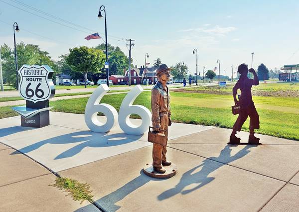
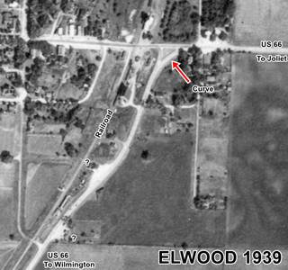
The current crossroads is a sharp turn, but the original 1926-39 US 66 that curved here avoiding the grade crossing on former IL-4 and downtown Elwood had a soft wide curve across what now is a grassy park area. You can see it in the 1939 aerial photo (click on it to enlarge it), it passed beside the railroad depot. And we don't see the Texaco or Standard stations in the picture, but two possible gas stations are marked further along the alignment with a question mark "?" beside the buildings that look like gas stations. Neither have survived.
Let's take a look at the symbols at the wayside exhibit:

Rosie the Riveter Source
Rosie the Riveter silhouette
The steel sheet silhouette at Elwood represents Rosie the Riveter carrying a lunch pail with her name written on it and raising her arm as in the iconic poster.
Rosie is a symbol of all the women who worked at factories during WWII, manufacturing goods while the men fought the war in battlefields abroad. They represent American women, their economic power and the rise of feminism.
Here she represents Elwood Ordnance Plant that employed thousands of women. She was painted by Norman Rockwell on the cover of The Saturday Evening Post magazine of May 29, 1943, a song was composed by Redd Evans and John J. Loeb in 1942, its title was "Rosie the Riveter." The women who worked at these sites producing material for the war effort called themselves "Rosies."
The stainless steel panel-marker tells us about the Elwood Arsenal and the role of civilians, especially women, during the war. The panel also mentions the critical role of Route 66, than served as a corridor for labor and shipments of raw materials and ammo from the ordnance plants.
Statue commemorating the Ammunition Plant Dead
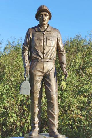
Arsenal worker monument, Elwood, Il. Credots
A statue of a munitions plant worker was dedicated to the workers who died in a terrible blast that killed 48 people in 1942.
The original statue was placed by to the entrance to the Abraham Lincoln National Cemetery in 2001.
The statue was stolen in 2005. But funds were provided by an anonymous donor so another statue was made and placed in the cemetery in 2008. You can see it in this street view. The original statue was found that same year in Braceville and now belongs to Elwood who set it up at the Wayside Exhibit.
Don't miss the Elwood Route 66 shield with the double-sixes, ideal for a picture.
Drive westwards along Douglas Street, the original US 66.
Original Road Section
There is a rare section of the original Route 66 in Elwood: Drive down Doulgas Street to drive over the original Route 66 pavement.
This original pavement was buried under later layers of asphalt and has been brought back to the surface after a renovation project.
Drive south along Douglas St. and then turn right towards Wilmington, just half a mile ahead on Hoff Road is the site of the former Elwood Arsenal, now a Natural Reserve (Midewin National Tallgrass Prairie). To your right is the Abraham Lincoln National Cemetery.
Joliet Army Ammunition Plant
Also known as the Joliet Arsenal, it opened during World War II to manufacture explosives and shells; it eventually produced 1 billion pounds of TNT.
It was part of a vast complex which consisted of the Elwood Ordnance Plant (EOP) and the Kankakee Ordnance Works (KNK). Both merged into one (Joliet Arsenal) in 1945 and remained active until 1976.
Explosion
On June 5, 1942, as World War II was at its lowest point for the Allies, there was an explosion involving anti-tank mines at the Joliet Army Ammunitions Plant. It killed 48 people and wounded 46.
This was the worst accident (in life loss) at a munitions plant during WWII, and it took place in building 10 at the Elwood Ordnance Plant
The Arsenal, that opened in 1940, was enormous spanning 23,542 acres (9,500 ha) with almost 1,400 buildings and 22,000 employees during WWII.
It supplied munitions during WWII and also the Korean and Vietnam Wars. It ceased production in 1976 and shut definitively in the 1990s. Parts of its vast surface were contaminated with chemicals.
The land was ceded to the U.S. Forest Service for restoration, which led to the creation of the Midewin National Tallgrass Prairie, another 910 acres were given to o the U.S. Department of Veterans Affairs for the national cemetery.
Abraham Lincoln National Cemetery
The law that created the 19,000 acre Midewin National Tallgrass Prairie also established the Abraham Lincoln National Cemetery, it was the largest national cemetery in the country for a short period of time until another national cemetery expanded its surface to be able to retain the #1 position.
This cemetery has 400,000 burial spaces.
It was named after Lincoln, who in 1862 signed into law the creation of National Cemeteries for the soldiers who gave their lives in the service of the country.
The Midewin National Tallgrass Prairie
This is the only federal tallgrass prairie reserve east of the Mississippi River. It is in the central forest-grasslands transition ecoregion of the temperate grasslands, savannas and shrublands biome.
With the neighboring Des Plaines Fish and Wildlife Area and a other protected areas, it covers 40,000 acres of protected land.
Healing the land
Midewin is a Potawatomi word for "healing", and it is a good name for the reserve.
The original prairie that once existed here was replaced by human activity: the bison were exterminated and cattle introduced to graze on the native grass. Then corn, wheat, and soybeans were planted by the settlers.
In 1940 this changed when the US government built the munitions complex: the farmers were forced to sell their land and the Arsenal occupied it.
But you don't make 1 billion pounds of TNT without contamination, and the area where the Arsenal once stood had plenty of heavy metal contamination (lead, arsenic) and polychlorinated biphenyls (PCBs) plus some unexploded ordnance.
The site was cleaned up and remedied by 2008 (280,000 tons of contaminated soil were bioremediated) and ground water monitoring is ongoing.
Twenty seven American bison were introduced in 2015 to graze (they will eat introduced species and allow the native ones to gain a foothold in the area).
Continue your Road Trip
This is the end of your Route 66 Road Trip across Elwood, head south into Wilmington and visit its famous Gemini Giant.

Sponsored Content
>> Book your Hotel in Chicago

Credits
Banner image: Hackberry General Store, Hackberry, Arizona by Perla Eichenblat
Jack DeVere Rittenhouse, (1946). A Guide Book to Highway 66.


