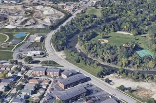
Route 66 in Lyons IL
Index to this page
Lyons IL
Facts, Information and trivia
Elevation: Elevation 703 feet (215 m). Population 10,411 (2022).
Time zone: Central (CST): UTC minus 6 hours. Summer (DST) CDT (UTC-5).
The town of Lyons is a suburb of Chicago, and it is located in Cook County, Illinois with two alignments of U.S. 66 across it.
History of Lyons
The area around Chicago was first inhabited when the ice sheets of the last Ice Age retreated some 11,000 years ago forming the Great Lakes. Later, in historic times, the Potawatomi people lived here and were encountred by the French explorers coming from eastern Canada in the 1600s.
France ceded the land to England as part of a peace treaty in the mid 1700s; after the American Independence they became part of the U.S. Shortly after, the American govenement established Fort Dearborn on the Chicago River in 1803.
The fort was destroyed by the British during the 1812 War but it was rebuilt in 1816. Two years later, the territory became the state of Illinois.
David and Bernardus Laughton opened a trading post here in what would become Lyons in the 1820s on the Chicago Portage. Cook County was established in 1835 and named after Daniel Pope Cook (1794 - 1827) a lawyer and politician as well as newspaper publisher. He was Illinois' first Attorney General, and an anti-slave advocate Congressman.
Cook County is, after Los Angeles County, the second-most populous county in America. Its county seat is Chicago./p>
In the 1840s workers building the Illinois & Michigan Canal came to the area. German settlers farmed in Lyons and a brewery opened here in 1856. By the 1880s a large inflow of Polish immigrants began and the town incorporated as Lyons in 1888.
The name "Lyons"
The origin of the name is uncertain but it may be due to the city of Lyon in France, which was named Lyon (Lion) in the thirteenth century.
In 1908, the owner of the brewery, Hoffmann, built an electric power dam on the Des Plaines River that runs through the town, and the Historic Hofmann Tower. Ogden Avenue was paved in 1914 linking Lyons with Chicago and the streetcar service of the Chicago & Joliet Electric Railway made travel easy.
Routes 66 and 34 were aligned through downtown Lyons in 1926. US 66 was realigned to the east and south of Lyons in 1928. After WWII a residential development boom modified to the area.

Accommodation in Lyons
> > Book your hotel in town: Chicago
Find More Accommodation close to Lyons along U.S. 66
Below you will find a list of some of the towns along Route 66 east and west of this town; click on any of the links to find your accommodation in these towns (shown from east to west):
Along Route 66 in IL
- Hotels in Illinois
- Route 66 Starting point ▸ Chicago
- Lockport
- Willowbrook
- Bolingbrook
- Plainfield
- Romeoville
- Joliet
- Wilmington
- Dwight
- Pontiac
- Chenoa
- Normal
- Bloomington
- Atlanta
- Lincoln
- Springfield
- Raymond
- Litchfield
- Staunton
- Williamson
- Hamel
- Edwardsville
- Collinsville
- Troy
- Glen Carbon
- Pontoon Beach
- Granite City
- East St. Louis
West in Missouri
- Hotels in Missouri
- Florissant MO
- Bridgeton MO
- St. Louis MO
- Kirkwood MO
>> See the RV campgrounds in Chicago or in Joliet.
The Weather in Lyons
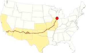
Map showing the location of Lyons, Illinois on U.S. 66
The climate of Lyons is humid continental, it has well marked seasons with hot and damp summers, cool and wet springs, mild falls, and cold winters.
Temperature: average high in Jan (winter) 31°F (-0.3°C). Average low is 17°F (-8.6°C). Average high in Jul (summer) 84°F (29°C), and an average low of 64°F (17.7°C).
Rainfall is between 3 and 4.3 (78 and 110 mm) inch monthly from April to November and some 1.7 in. monthly (28 mm) during winter. Average rainfall is 36.82 inch (936 mm).
Lyons gets 28 inches of snow per year (71 cm). The first snowfall is in November and the last one in April (less than a 1⁄4 inch - 8 mm). You shouldn't see snow from May to September.
Tornado risk
The region around Lyons experiences about 4 tornados per year. Tornado Risk: read more about Tornado Risk on US 66.
The Maps of Route 66 in Lyons
>> Our Custom map shows the different US 66 alignments in Lyons.
The map below was published in 1924, two years before the creation of U.S. Highway 66. The map displays the Auto Trails in NE Illinois around Chicago.
Auto Trails were highways that were in good conditions and could be used by motor vehicles. Some are marked with numbers inside black boxes; they are the "named trails." Like "34" that was the "Lincoln Highway" which can be seen running into Joliet and across Plainfield. Illinois State highways are marked with numbers inside white circles. For instance Route 66's predecesor State Highway 4 is marked with a "4" inside a white circle. It can be seen running from Chicago to Lyons, and then south through Lemont and Lockport to Joliet along the south side of the Des Plaines River. Route 66 was aligned along it from 1926 to 1928. We marked it with an orange line in Lyons, and a bordeaux line through Lemont to Joliet in our custom map.
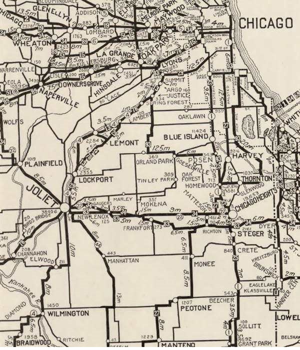
The map shows LaGrange and Lyons.
Route 66 and Lyons

1927 Chicagoland map. Source

1928 Illinois State roadmap (see State Hwys 4 and 4A). Source
The 1927 and 1928 show Lyons. Route 66 was realigned in 1928 along the western side of both waterways and south of LaGrange through Romeoville marked with the violet and pale blue lines in our custom map.
US 66 from 1956 to 1977

1969 Illinois State Roadmap. Source
Click map to enlarge
The state highway map of 1959 shows changes: US 66 south of its fork with ALT 66 is an "Expressway" with "highway separation" (overpasses and limited access). It has also bypassed Plainfield, leaving the old 1940-58 US 66 aligmnent to become IL-126 and IL-59.
During the 60's, the urban sprawl expanded. The 1969 state highway map (pictured) has I-55 and US-66 running together until the exchange with I-294, where they split, I-55 running further south and US-66 north. However it does not show Lyons, only neighboring Berwyn.
Route 66 is a Historic highway and has also been designated as a National Scenic Byway and an All-American Road in the state of Illinois.
The old Route 66 is a Historic highway and has also been designated as a National Scenic Byway and an All-American Road in the state of Illinois.
The Route 66 alignments near Lyons
Description and interactive maps of US 66.
- Pontiac to Springfield (next)
- Chicago to Pontiac (Lyons')

Lyons's Route 66 Landmarks and Attractions
Some tours in Chicago
Sponsored
Some tours and sightseeing
What to see in Lyons
US 66 in Lyons: historic context
The WPA guide to the state of Illinois published in 1939 describes Lyons in its "Tour 17" along Route 66; it tells us that it was built at the portage between the Chicago and Des Plaines Rivers and that "today Lyons is largely residential, its working population finding employment in nearby manufacturing towns and in Chicago."
This leg of your Route 66 Road Trip in Lyons
Drive along Historic Route 66 from Berwyn into Lyons. At the intersection Ogden Avenue and Harlem Avenue you enter Lyons. First let's brush up on the history and the origin of Ogden Avenue.
Ogden Avenue
This avenue runs for 37.5 miles (60.4 km) from Chicago (Chestnut St. near Milwaukee and Chicago Avenues) all the way to Naperville, Illinois.
It was named after the first mayor of Chicago: William Butler Ogden.
When Chicago was merely an outpost on Lake Michigan named Fort Dearborn in the early 1800s, there was a muddy trail used by trappers known as the "Ottawa Trail" that went west to what is now Lisle. It improved gradually and in the 1830s a stage coach service was established along it with a stop in neighboring Hinsdale.
Cart traffic made deep ruts in the dirt trail and rain made the road a muddy, impassable bog. So some entrepreneurs built the "Plank Road."
Plank Road
Construction began in 1848 and it was known as "The Southwestern Plank Road", it was the first of many that would radiate from Chicago. This one followed the trail to Lyons and in 1851 it was extended through Lisle to Naperville.
The road was built with wooden planks with log stringers on their outer edges. The boards were 3 in. thick and only 8 feet wide.
Toll fees were charged ranging from 3¢ for one hog or sheep, 12¢ for a horse and rider to 37¢ for a cart drawn by four hourses.
When the Chicago, Burlington and Quincy railroad began operating in 1863, the traffic along the plank road declined.
It was re-named in 1877 as Ogden Avenue. The planks were removed and it was surfaced with gravel. But by the early 1900s the first cars appeared and by 1914 it had been paved becoming a main throughfare.
Route 66 and US 34 were aligned along it in 1926 and in the 1930s it was widened to four lanes.
Here at Ogden and Harlem Avenues there is a fork in the alignment of Route 66.
- The 1926-28 US 66 alignment. It runs straight, westwards along Ogden into Lyons, and then south along Lawndale Ave. (orange line in our custom map)
- The 1929-77 US 66 alignment. It skirts central Lyons, and turns left to head south along Harlem Ave, and then with a NE-SW course to cross the Des Plaines River south of the town, along Joliet Rd. (pale blue line in our custom map)
We will drive along both alignments in Lyons, starting with the 1926-28 one, that also carried US Higway 34. Head straight along Ogden. Ahead, to your left is a classic motel.
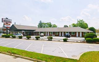
Chicagoland Motel
At 7225 Ogden Ave, Lyons. The postcard of the Chicagoland Motel below dates back to 1931. In 1956 its advertisement informs it was owned by Mr. and Mrs. Alfred Bort. A more recent postcard from 1960 tells us that it had "28 Ultra Modern Units - Open Year Round - Television - Telephones - Radio... Chicagoland's Finest Motel... Minutes from Downtown Chicago."
The place is still open and operating as a motel and has had some modifications but the long hip roofed rectangular building is clearly visible.
Chicagoland Motel 1930s postcard in Lyons, Illinois
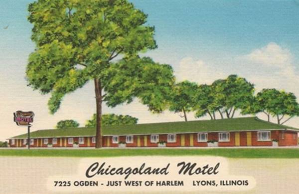
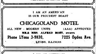
Chicagoland motel, 1956 ad. Source
Chicagoland consists of the Chicago metropolitan area in northeastern Illinois, including Chicago and its surrounding suburbs. Lyons forms part of it.
Plank Road Inn
Keep westbound and to your left just past the Chicagoland Motel is another motel at 7307 Ogden Ave, Lyons. This 36 room building built in the late 1960s. It is one of several built in Lyons with a Swiss chalet look, the style was popular at that time, and consists of shallow-pitched roofs, brick or rough limestone walls,
overhangs and wood railings. Built to convey a feeling of warmth and coziness during the tough freezing Lyons' winters.
Dring the 1980s it was "Sullivan's Motel."
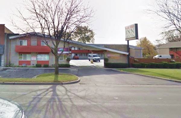
Ahead the highway crosses the Des Plaines river entering the downtown district of Lyons with several red-brick commercial buildings from the late 1800s.
Mangam's Chateau (gone)
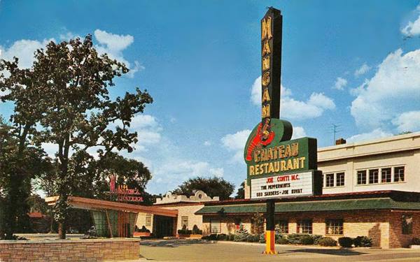
At Amelia Ave to your right, at 7850 Ogden Ave. where the McDonald's now stands. Mangam's Chateau opened in 1937 and remained open until 1979. It was one of the best restaurant - nightclubs in the Chicago area. Its postcard boasted that it was "Chicagoland's largest and smartest Theatre Restaurant and Supper Club."
The nightclub was named after Helen Mangam (1898-1989), born Sklodowski in Warsaw, Poland she migrated to the US in 1906, she married Fenton Mangam a successful real estate man who lost everything in the Great Depression. The couple sold their remaining belogings and bought a restaurant in Lyons in 1939 and named it the Tower Inn. They grew and in 1944 purchased an old roadhouse, the DesPlaines Chateau that they renamed Mangam's Chateau. It grew to have 250 employees. After Fenton's death in 1960, Helen ran it until 1974 when she sold it. It closed for good in 1976. The place burned in 1979 and arson was suspected. It was just a few days before it was to be demolished.
Some old Pharmacies on the original Route 66
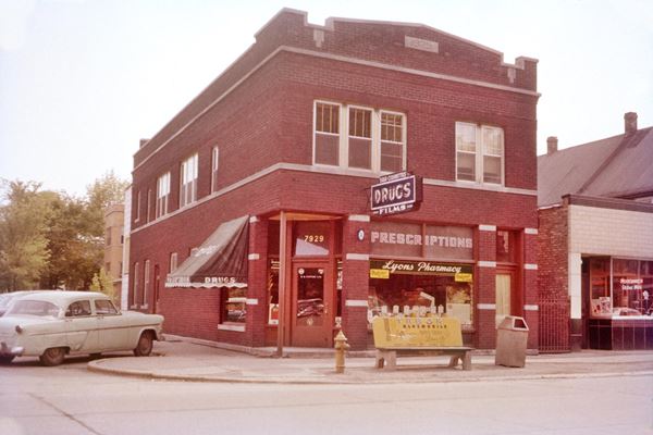
On the next corner was Lyons Pharmacy, at 7929 Ogden, to your left, followed one block west at 7950 Ogden Ave by Grosse pharmacy, to your righyt. Below are a set of "Then and Now" images of both pharmacies, in the 1950s and nowadays.
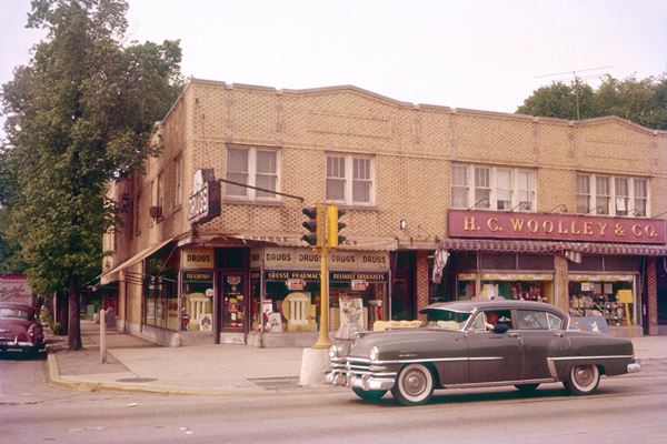
Ahead the highway curves slightly at at Joliet Ave. take a right towards the Des Plaines river to visit the historic tower. There is parking space beside it.
Hofmann Tower Museum
Listed in the National Register of Historic Places, Village and State Landmark
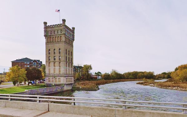
At 7930 Riverwalk Drive on the river. A local brewer, George Hoffmann Jr. built a dam on the Des Plaines River to generate electricity and also added this eigh-story tall tower in a park as a tourist attraction back in 1908.
The stone tower was built by H. W. Sauber using German plans on Hoffmann's property; it cost $400,000 of those days. The first dam here was built in 1830 for a mill, and improved over the years. People would picnic there and row in the river.
Hofmann Tower Museum in Lyons, Illinois
Hofmann's Triangle builting (gone)
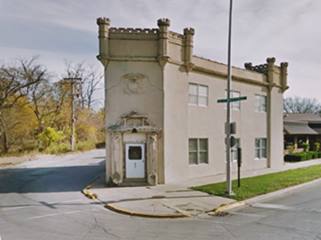
On the SE corner of 39th St. and Millbridge Rd, just east of the tower was the site of Hofmann's office. It was a two story stone building with a castle-like style to it. It had an Art Deco entrance portico and the Hofmann coat of arms above it. It burned in Nov. 2013 and was levelled.
The triangle building was probably built in 1857. The place had been a bar or tavern in the late 1800s and sold Hofmann's beer and lager. He reformed it around 1910 to make it fit in with the tower.
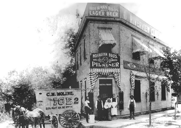
Janda's Drive-In (gone)
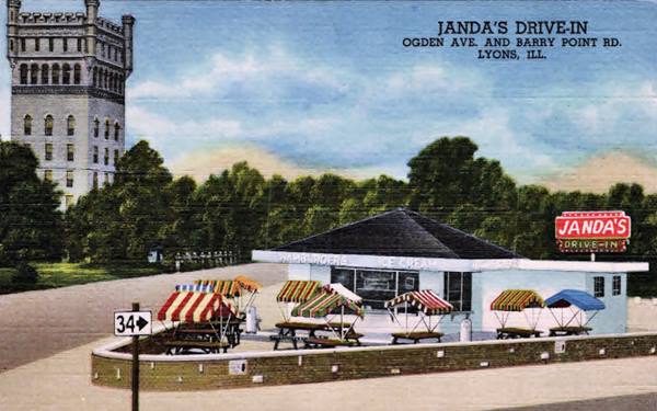
Return to Ogden and just ahead, to your right, by the two six-story red-brick apartment buildings, was a now gone drive-in; At 8030 Ogden Ave., its postcard stated: "Janda's Drive-In Enjoy hamburgers and Bar-B-Q's at their best in our open air picnic pavilion. Malteds - sundaes - sodas." This is the view at the same spot shown in the 1940s postcard below. The same Tower in the distance.
Ahead, Route 66's 1926-28 alignment splits from US 34, by turning left, southwards along Lamont Ave. Below is a 1940s and a current view of the fork. Notice the gas station and cafes that were located by the Des Plaines River, now gone.
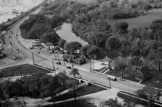
Aerial view of western Lyons c.1940. Click to enlarge. Source
Turn west along Lamont it goes through a residential area with several commercial or industrial brick buildings, perhaps some of them were garages during the Route 66 days (like the ones at 4320, 4330, and 4400 Lamont). Keep south until the road intersects 47th St. South of this point there are no stops or points of interest until you reach Joliet Road 1⁄4 mi. south; Joliet Rd. was the 1929-77 Route 66 and we describe it in our McCook page.
So, turn left along 47th St. and head east back towards Lyons. Roughly 1⁄4 mi. east you will meet Old Route 66 with a north to south course. On the NE corner is a garage, and its building appears in the early 1960s aerial photos, it seems to be a former gas station (street view).
Chicago Portage National Historic Site
National Historic site
It is a short 2.4 mile round trip to visit it, see this map with directions, along 47th St. and just south of it, after crossing the Des Plaines River.
The Des Plaines River runs with a north to south course parallel to the coast of Lake Michigan, near present Lyons the river received, on its eastern side, the inflow of Portage Creek and curved, adopting a NE-SW course. Downstream it meets the Kankakee River and forms the Illinois River, which in turn flows into the Mississippi River.
Des Plaines River
The river runs through the city of Lyons. Its course is 133 miles (214 km) long and its water reaches the Gulf of Mexico through the Mississippi River. The first French explorers called it the "River of the Plane Trees" as the trees along it resembled the French plane tree.
To the east of Lyons the Chicago River with its northern and southern branches ran eastwards and it flowed into Lake Michigan, with its water reaching the Atlantic Ocean along the Great Lakes and St. Lawrence River.
Between Portage Creek and the S. Fork of Chicago river there was a gap on the "continental divide." This was a marshy area known as "Mud Lake." When it rained heavily or if there were ice dams downstream, the Des Plaines River could back up and flow eastwards, across Mud Lake and into Lake Michigan via the Chicago River.
The Native Americans used these rivers for trade and travel, and portaged their canoes across the divide. When the French explorers reached the area in 1673, rowing upstream along the Mississippi and Illinois Rivers their native guides showed them this strategic portage point between the Great Lakes and the Mississippi basins.
Father Jacques Marquette and Louis Jolliet were the first Europeans to use it, and there is a statue in hte parkcommemorating that event (pictured below). The portage was a muddy slough 8 mi. long (13 km). René-Robert La Salle (1643-1683) a French explorer realized its strategic importance.
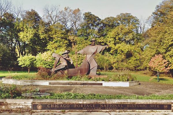
As mentioned further up, the Indians ceded the mouth of the Chicago River to the US by the Treaty of Greenville (1795), in 1803, U.S. soldiers erected fort Dearborn at the river's mouth. It was rebuilt it in 1816 because the natives had burned it down during the Anglo-American War of 1812.
Illinois & Michigan Canal
A group of businessmen organized to build a canal to link the Great Lakes with the Mississippi River across the Chicago Portage to move their farm's produce and trade with the eastern states, and also allow goods to move west, linking the Great Lakes with the Gulf of Mexico via the Illinois and Mississippi rivers.
In 1825 the State Legislature incorporated the Illinois and Michigan Canal association, but the construction of the canal was delayed many years. Work started in 1836 and concluded in 1848. It cut through the divide and linked with locks both rivers Chicago and Des Plaines. It closed for good in 1935 after being replaced by the railroad and by the Chicago Drainage Canal that was dug in the 1890s, parallel to the old I&M canal, to be used not only for navigation but also to send the raw sewage of Chicago westwards so that it didn't taint its drinking water supply (Lake Michigan) and help eliminate the constant cholera outbreaks.df
Below is a 1750s French map of the western regions of "New France" (Canada), show the "R(iviere) et Port de Checageu" (River and Port of Checageu) the Checageu River and, marked with a Red arrow, the "Portage des Chenes" (Portage of the Oaks) that linked it to the R. des Illinois (Illinois' River)
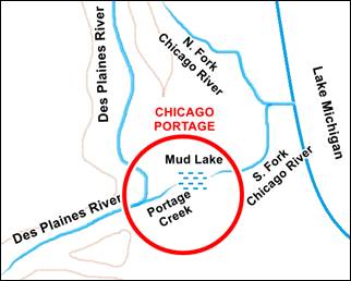
Chicago Portage map, Lyons, Il. A. Whittall
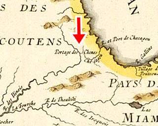
Chicago Portage in a 1700s map, Lyons, Il
Back on Old Route 66
Return to the original alignment of Route 66 the same way you went to the park, and at the old gas station turn northwards and dirve along Old Route 66; this is the 1929-77 US 66 alignment into Lyons. The area is similar to Lamont Ave. with homes and commercial buildings. Less than half a mile north the highway curves eastwards. Ahead at 7729 W 43rd was Pedicone's that offered "Finest Italian Viands and Delicacies (Old World Food ina New World Setting)" it was open from 11:30 AM to 4:00 AM daily. Owned by Fred and Al Pedicone. By 1963 it had become involved with the Mob and John Tano was the restaurant's owner that burned mysteriously on January 1, 1963. Tano died shortly after of an apparent heart attack. Ernest "Rocky" Infelice, a crime syndicate enforcer and ex-convict was suspected of arson; three restaurants of which he was a behind-the-scenes owner had burned down since January 1961.1
The road curves and crosses the Des Plaines River and the Chicago Portage Park and turns north along Harlem Ave.
Fairyland Park Site
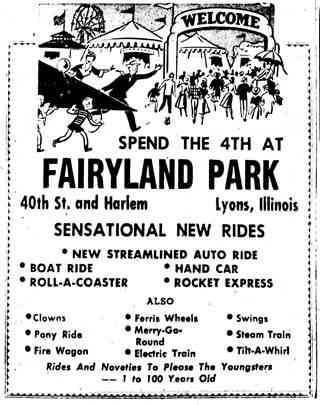
1953 Fairyland Park ad, Lyons, Il. Source
Ahead, at 3938 South Harlem Ave; to your left, on the NE corner with 40th St.
The park owned by Helen and Richard Miller Sr. began in 1938 as a typical country fair witha Ferris Wheel, a small steam train that ran around the park, Bumper Cars, and pony rides. Over the years it grew and spanned five acres. After the death of his father in 1965, his son took over and kept it going until 1977. By then more than 3 million visitors had enjoyed the park. It was sold and torn down the next year.
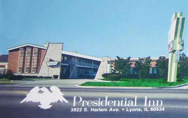
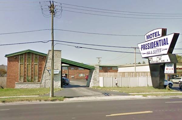
Presidential Inn & Suites Motel
On the north side of the former park site, at 3922 S. Harlem Avenue, Lyons. A fine example of Lyons' Swiss chalet style (see the overhang across the entrance and the stone and brick facade). This motel opened in 1961 as a family vacation motel and is still lodging guests as the Welcome Motel.
Continue your Road Trip
And here, where you began your drive, is also the end of this leg of your road trip through Lyons you can turn around and continue south (west) along Route 66 into McCook.

Sponsored Content
>> Book your Hotel in Chicago

Credits
Banner image: Hackberry General Store, Hackberry, Arizona by Perla Eichenblat
Jack DeVere Rittenhouse, (1946). A Guide Book to Highway 66.


